Sarcele-Corbu
>>>back to working groups overview
| Area | Workgroup 1: Săcele-Corbu | |
| Place | Sacele Corbu | |
| Country | Romania | |
| Topics | please enter the main coast-related topics here | |
| Author(s) | Anton Iulia-Alina, Gonțilă Larisa Cristina, Iuca Maria Monica, Ivănescu Maria-Alexandra, Giurgiu Andreea | |

| ||
Rationale
- Why do you think this case is relevant? What is your hypothesis considering the landscape challenges?
Sacele-Corbu area is very important as a mixt scientific reserve that is part of Danube Delta Biosphere Reserve (DDBR). The area is characterized by the species of birds that give a special fauna to this area, of which a large number are protected species. The site is a major wintering and passage site for numerous bird species, such as Red-necked Goose (Branta ruficollis). The plants in the area have a very important role in soil stabilization and erosion erosion. It is also an area that is already dedicated to practicing the helium-sea tourism and is characterized by wild beaches. The two areas have no tourist destination but are part of the Danube Delta Biosphere Reserve, being a public domain of national interest.
Location and scope
You can edit this map with the map editor
A Landscape System Analysis
A.1 Landscape layers and their system context
Geomorphology, landscape units and coastal typology
According to the geomorphologic division of the coastal area, our area of interest is part of the Nordic Unit where for the boundary of the coastal zone, the width shall be set at the maximum limit of 150 m from the longest line of the sea (Governamental Decision 749/2004).
On the territory of Săcele commune, the coastal area falls within the Chituc Grindel area, in the buffer zone of the RBDD and in the economic zone of the RBDD, as described in the functional areas of RBDD of GD 248/1994 - Annex 1. - On the territory of Corbu commune the coastal area falls within the economic zone of the RBDD;
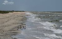
The sedimentary unit from this area is from the Zatoane to the Midia Port and is divided into two sub-sectors Chituc and Corbu (Cape Midia). Chituc Description: Length about 19 km. Beaches formed by a series of fossil barrier beaches, made up of sediments brought by the Danube, redistributed by waves and currents, and shells. Type of shore, sedimentary characteristics: Severe coastal sedimentary stream moving southwards. The sediments are brought by the Danube, with a quantity of shells. There are significant amounts of heavy minerals present in beach sediments due to relative enrichment (selective remobilization of light silicon minerals, while heavy minerals have remained or have been transported at smaller distances). The coastline is north - east - south - west from Portita to Midia, and is exposed to the strongest windstorms in the north. There is, therefore, a strong supply of seaside sediments in the south. This area faces mild erosion, but is generally stable along the southern unit, where a certain influence of the Midia dams can be felt. Coastal dynamics: Poor-stable erosion to the south (approximately 1.5 m / year)
CORBU - CAP MIDIA Description: Length about 13 km. Pocket beaches accumulated in front of the cliffs. There is no contribution from the cliff, which is mainly composed of the banks. Sediments are from the Danube and consist of shells. It is a natural area without protection. Type of shore, sedimentary characteristics: The southern jetties traps sediments transported here by shore-side current. For this reason, this sector acts as a sediment reservoir. Coastal dynamics: Stable / weak acreage


Land use
- History of area use
Corbu - Corbu villages dates back to the first Iron Age - 13th century- middle of the 4th century BC, close to the water spring. The practices were then agriculture, animal husbandry, fishing, crafts, commerce, but also the exchange of goods between the local population and the Greek settlers.
Sacele - Situated about 12 km south of Histria fortress, the area of Sacele commune, was part of the territory of the fortress. Histria Fortress was founded at the end of the 7th century BC as a port on the shore of the current Sinoe lagoon - the former open sea.
- The current situation
On the administrative territory of Corbu commune and Sacele commune there are a number of uses of the area. Housing, with a population of 5450 inhabitants in Corbu, 2100 inhabitants of Sacele. The transport infrastructure includes: county roads (DJ 266), communal railways and railways. Other activities are: mining holdings for limestone extraction and consecrated aggregates, sport fishing, hen farm, harbor, grain farming (90% of the population involved in Sacele), tourism, industry, services, recreation, public space and water and energy supply services. Another important area is Chituc Grindul afferent to the protected natural area (belonging to the Danube Delta Biosphere Reserve), where birds of different species are found (289 protected species have been identified in Grind), low-water lakes partially covered with floating vegetation; flooded depression areas with fixed hydrophilic vegetation, represented by reed and rush communities; meadows on low coasts and less-favored coastal meadows.
Other important areas for loisir are Corbu Lake, Corbu Beach and Vadu Beach (virgin beaches). Recently, a Local Urban Plan has been developed and includes proposals for a new tourism development and private housing on the shore.


Green/blue infrastructure
In the studied territory there are areas that have potential for developing a green-blue infrastructure such as healthy ecosystems and naturally valuable areas outside protected areas such as floodplains, wetlands, coastal areas, natural forests (Vadu Forest) which can act as ecological corridors or animal shelters. Present in site are Chituc Grind and the Ornithological Retreat Corbu - Nuntasi – Histria areas, part of the Danube Delta Biosphere Reserve ( recognized as a wetland of international importance since 1990), where bird species of special importance to this area are encountered, a very large number of birds are protected species and is also the only place where the Jackal can be found. The site is a major wintering and passage site for numerous bird species, such as Branta ruficolli.
In the area, measures are being taken regarding the ecological reconstruction of degraded surfaces, the reduction of industrial activities (Raw Metals Factory from Vadu for Siliciu). The wind farms are presented in this area, and for stimulate the developement of new farms, Agency for Payments and Intervention for Agriculture has provided support to farmers by offering subsidies for: - Arable land important for red-breasted goose feeding areas, - Important meadows for birds, - Maintaining organic farming practices, - Etc.
Mayors have agreed that measures need to be taken, such as: • Mounting of RBDD boundary alert and signaling panels, as well as panels with information on access conditions in RBDD and beach activities; • Establishment of common parking spaces and arrangement of parking areas for motor vehicles, location of barriers so that activities in the beach area are made terrestrial; • Daily hygiene of beaches by the mentioned municipalities; • Continuous monitoring by ARBDD commissioners of beach areas including entry / exit paths.
The area is part of the project "Dobrogea Nord - Wild Earth between the waters" which aims at sustainable development of fisheries areas.
-
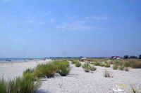 Corbu Beach
 -
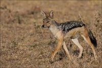 Jackal
 -
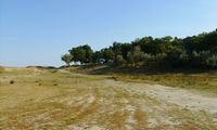
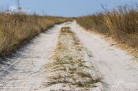 Grindul Chituc
 -
 Grindul Chituc
 -
 Vadu Forest


Actors and stakeholders
The actors and stakeholders from this area are represented by:
1. Local, regional authorities - administer the area with administrative measures;
2. “Romanian Waters” National - deal with the monitoring of the lakes in the area, the coastal zone afferent to the Black Sea and the defense against floods;
3. Non-governmental organizations, NGO:
     - Mare Nostrum, dolphin monitoring, placement of information panels, etc.;
     - WWF, is working in the framework of the regional Danube-Carpathian Programme;
     - Romanian Ornithological Society (SOR) carries out activities for the protection of birds and nature;
     - Various NGOs dealing with saving Chituc Grind.
4. Administration of the Danube Delta Biosphere Reserve (ARBDD) deals with the management of the natural heritage of the public domain of national interest of the Reserve, as well as for the restoration and protection of the physico-geographic units on the territory of RBDD;
5. Army force, there is a military unit in the area;
6. The economic agent
     - Restaurants;
     - Accommodation;
     - The Carslyle Group which now owns the Black Sea Oil&Gas company are planning to build the gas pipeline with the national state-owned Transgaz company (in which Eurodeputate Theodor Stolojan owns over 5000 shares valued at about 230.000 euros).  The gas transportation pipeline will start construction from the pickup point (from the Black Sea), which is 2000m from Vadu town through to the tranzit 1 pipeline which is in the area of the town Gradina. More than half of the lenght of this pipeline will pas through the communes Corbu and Sacele.
7. Research Institute and Universities;
8. Historical - there are archaeological sites in the area;
9. Tourists - practice tourism in nature;
10. Animal breeders, fishermen and farmers.
Sacred spaces and heritage
Chituc - This sub-sector supports an important marine ecosystem, which is reflected in the designation of protected areas within the Danube Delta Biosphere Reserve (SCI, SAP and Ramsar sites) both through its delta area and its marine components . The Danube Delta sustains a significant number of protected habitats and species. The Black Sea SAP is also in this sub-sector. There are two protected cultural locations (Categories A and B) located in the immediate vicinity of Sinoe Lake; they are located near the sub-sector's border. There is a designated designated area for the development of crustaceans, intended for the growth and exploitation of marine molluscs (between Perisor and Chituc).1 CORBU - This sub-sector supports an important marine ecosystem, which is reflected in the designation of protected areas within the Danube Delta Biosphere Reserve (SCI, SAP and Ramsar sites) both through its delta area and its marine components . The Danube Delta sustains a significant number of protected habitats and species. Black Sea SAP and Taslu Lakes up to Corbu SAP are also in this sub-sector. Cultural heritage includes: CT-I-s-B-02632, Archaeological site; CT-I-m-B-02632.01, Romanian Settlement from 1st to 4th Century, Ap. Hr .; CT-I-m-B-02632.02, Latenei Placement, Greek-Getic Culture, V, BC; CT-I-m-B-02632.03, Settlement, Hallstatt Late Age, VI-V a.Chr.1
Visual appearance and landscape narrative
“The Anchor of Danube Delta”
Landscape character is a mixture between the wild flora, fauna, and sights of the landscape. The character of the area is seen from two different point of views: the realistic one, and the subjective one, in which the filter of understanding and perception of each person interferes (the landscape is seen, smelled, heard, felt). Thus, this area, including the Danube Delta, represent an inspiration for many artists all over the country in the last century, but for foreign ones as well.
Mihai Sadoveanu (1880-1961), Romanian writer from Iași, describes the Danube Delta, including Săcele-Corbu area in the volume called “The country after darkness” (“Țara de dincolo de negură” 1926), in the narrative called “The Mirage” (“Mirajul”). He describes the area as wild, “like entering another life, or a fairtytale”. He discovers the area slowly, step by step, from the smallest detail, to the greatest element. Essential elements described are related to fauna and flora (he reminds of different bird and growth species). Alexandru Vlahuță (1858-1919), Romanian writer from Vaslui, describes the area in the volume called “Pituresque Romania”(“România pitorească” 1901). He also describes the area as a wild, virgin area, less touched by mankind: “this deep silence, fully controlling everywhere, makes you think you are away from Earth, in a lonely planet”. He concentrates his narrative on the Danube itself, the river is ruling the place, how the little boats and birds are seen from great distance, wild horses are surprised by human presence, the vegetation is untamed. Besides the narrative description of the Săcele-Corbu and Danube Delta area, visual representation as paintings are common. Contemporary artist such as Adrian Timar, Voineagu and others find their muse in this area. Their paintings are capturing the wildness, the flora, the fauna, the cliche lonely fisherman with small boats passing.


A.2 Summary of you landscape system analysis and your development Targets
- Hypothesis
The Sacele - Corbu-Chituc area is important due to the fauna and flora resort, the possibilities of research on rare phenomena, and the virgin beaches. This area supports rare endangered species and contains valuable preserved landscapes. If no protection measures are taken against major interventions, the area will be exposed to massive degradation, it will lose its protected species, and the soil will destabilize due to flooding that may occur


A.3 Theory reflection
- Reflect on at least three international policy documents in relation to their local landscape case
- choose one international, one European and one national document
- You can choose references from our reading list
- Scope: 250 words
A.4 References
- give a full list of the references you have used for this section
Phase B: Landscape Evaluation and Assessment
B.1 Assessment Strategy
- Based on the hypothesis derived from your previous landscape systems analysis you are now asked to define the goals for assessing the landscape. Your assessment is the basis for evaluating the landscape status.
- Which elements and phenomena need to be mapped, why and how?
- This a text contribution, max 250 words
B.2 Mapping
- As defined by your assessment strategy you conduct the mapping and present your findings here
- As a minimum, at least three different themes need to be mapped, you may choose more if needed
-
briefly explain the findings of your mapping
-
briefly explain the findings of your mapping
-
briefly explain the findings of your mapping
B.3 Problem definition and priority setting
- Give a summary of the major findings of your mapping process, what are the problems/potentials identified?
- Draw a problems/potentials map
- Set priorities for the most relevant issues
-
add caption here
B.4 Theory reflection
- Please reflect the assessment and evaluation methods used based on at least three readings
- Did you encounter limitations'
- 200 words test contribution
B.5 References
- give a full list of the references you have used for this section
Phase C – Strategy and Master Plan
C.1 Goal Setting
- Define strategic planning objectives based on the evaluation findings
- Link back to your original targets from section one and the Development Goals
- 150 words text contribution
C.2 Spatial Strategy and Transect
- translate your strategic goals into a vision
- develop a spatial translation of your vision
- exemplify your vision in the form of a transect with concrete interventions
- add map(s) and visualizations
-
add caption here
-
add caption here
-
add caption here
-
add caption here
C.3 From Theory of Change to Implementation
- For implementing your vision: Which partnerships are needed? Which governance model is required?
- Who needs to act and how? Draw and explain a change/process model/timeline
- Which resources are needed? On which assets can you build?
- add 150 words text and visuals
-
add caption here
-
add caption here
C.4 References
- give a full list of the references you have used for this section
D. Process Reflection
- Reflect in your intercultural and interdisciplinary team on the outcomes of your study
- Which limitations were you facing?
- What have you learnt from each other?
- What would you do differently next time?
- You can also use diagrams/visuals
- 250 words text