Peipsi Lake from Kallaste Southwards
>>>back to working groups overview
| Area | Peipsi Lake | |
| Place | Kallaste and surroundings | |
| Country | Estonia | |
| Topics | Sand stone coast: folklore culture, agriculture and tourism | |

| ||
Rationale
Since the 18th century, the old Russian Orthodox belivers use to live on the Estonian side of the lake, which is the 5th largest in Europe. Along the coast, which is the longest sandstone coast in Estonia, it is possible to find at least 11 outcrops whose highest is proctected since 1959. This is why it is important to keep the cultural heritage and the unique landscape, which made out of this place, a touristic spot. Moreover, the lake is an important ressource of fishies and the water management is really important in these regions where the land use to be big arable aareas in both Estonian and Russian side, which caused eutrophication of the water.
Location and scope
You can edit this map with the map editor
A Landscape System Analysis
A.1 Landscape layers and their system context
Geomorphology, landscape units and coastal typology
Coastal area of Peipsi is flat. Geological substructure is devonian era sedimentary rock of Aruküla Stage (350 mln years old). In the late ice-age and at the beginning of Holocene, the current lowland was under the water. Sedimentary rock is covered with glacial and post-glacial lake sediments (sand, clay, organical sediments).
-
 Lake Peipsi shore by Elvis Kõll
 -
 Peipsi lake at Kallaste by Laima Gūtmane


Land use
During the Soviet time, the fisherman and the farmers around Peipsi lake use to sell their production along the Hansa traiding organization ways, from the middle age. Since 1992, the borders make it hard for traders. Around the lake, the land use to be arable in both sides, but the new intensives agricultural technologies and chemical created eutrophication phenomenon in the water of the lake, especially because of the forest cuts, the trees can not absorb the chemicals anymore. However, the economics problems of Russia and Estonia made fishing decrease. Considering the lake as one of biggest fish stock in Estonia with 33 different species, the fish reserve is nowadays under-exploited.
-
 Land use map of Kallaste
 -
 Amount of commercial fish catches in Peipsi lake


Green/blue infrastructure
The major potential elements of a green/blue infrastructure network are:
- Wetlands with reeds and bulrush
- Alatskivi Landscape Reserve
- Alastkivi Park
- Lake Peipsi watershed (Emajõe Suursoo and Remedovsky)
- Lake Alatskivi
- Lake Lahepera
- Watershed of Narva River (77km)
Due to the increased load of nutrients caused by human activities, eutrophication, caused by the high nutrient load, is a major threat to water quality in the lake.
Lake Peipsi receives pollution mainly from two sources: river water and precipitation directly into the lake. The nutrient content in the rivers of Lake Peipsi basin was high at the end of the 1980s, causing eutrophication of water bodies.
The wastewaters and gaseous emission of toxic sulphur and nitrogen oxides, hydrogen chlorine and carcinogenic compounds from power stations operating on pulverized oil shale have a considerable impact on the chemical composition of water in Lake Peipsi.
As one travels from south to north the content of total nitrogen decreases, while water transparency increases. The first trend is caused by the impact of the pollution loads from big cities like Pskov and Tartu, the second by the sediment pumped from the mines when it finally reaches the lake.
Also large-scale expansion of reeds has taken place. The intensive agricultural activities caused eutrophication to accelerate in the lakes and rivers.
Despite the drop in mineral fertilizer use during the last 10 years and a decrease in the number of domestic animals in the Lake Peipsi watershed, the impact of the earlier agricultural pollution is still significant.
The pollutants that were discharged into the lake remain in the lake bottom sediments for years (Roll & Abercrombie 1997). Cuts of forest in the watershed have resulted in considerable increases in the discharge of dissolved and solid phosphorus, nitrogen and potassium in run-off waters that flow into Lake Peipsi.
Regarding the Natura 2000 Network, the site has two types of directives:
- Habitats Directive Sites (pSCI, SCI or SAC) - These sites could be of proposed Sites of Community Importance (pSCI), Sites of Community Importance (SCI) or Special Areas of Conservation (SAC).
- Birds Directive Sites (SPA) - "According to scientific criteria such as ‘1% of the population of listed vulnerable species’ or ‘wetlands of international importance for migratory waterfowl’"
(source: http://ec.europa.eu/environment/nature/legislation/habitatsdirective/index_en.htm)
Regarding Alatskivi Landscape Reserve, it's known that it was established in 1964 to protect the Alatskivi Park and Valley, as well as the regional cultural heritage landscapes. (source: https://www.visitestonia.com/en/alatskivi-cultural-heritage-landscape-and-nature-centre)
-
 Wetland with reeds and bulrush by Triin Olvet
 -
 Natura 2000 information map of Peipsi Lake. Base map source: http://natura2000.eea.europa.eu/
 -
 Green infrastructure map. Alatskivi Landscape Reserve photo by Sergei Gussev.
 -
 Blue infrastructure map. Lake Alatskivi photo by Kristjan Lust. Lake Lahepera photo by Mmh. Lake Peipsi photo by Silvana Gallone.


Actors and stakeholders
The coast of Lake Peipsi from Kallaste to Varnja is the eastern boarder of the recently formed municipality called Peipsiääre. It’s formed from 5 former municipalities: Pala vald, Alatskivi vald, former Peipsiääre vald, Vara vald and Kallaste town.[1] How the state funding are going to divide under the new management the time will show. The main impact area is the settlements at the coast of Lake Peipsi. Fishing tradition in those settlements reach back in many years and reducing fishing quotas putting professional fishermen under the pressure as well as the appearance of the traditional fishermen farms where the obvious objects of active fishing will disappear. In Kallaste the fishing industry is the biggest employer.[2] Besides fishing there are two characteristic activities to this area which gives great touristic potential to improve economic situation. In 2009 non-profit organization Sibulatee was created. It had one mission – connect active community members and entrepreneurs to develop tourism and to introduce the diverse culture of the area. The organization helps the local entrepreneurs with the marketing in the web. The web platform sibulatee.ee brings together over twenty local companies. It organizes the cultural events and fairs to attract public attention to area which should enliven the environment. Sibulatee introducing the area with the words – One area, two nationalities, three cultures[3].
-
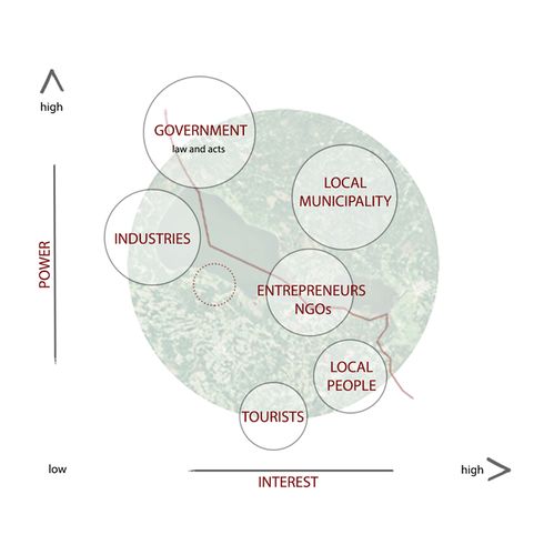 Power Map

Sacred spaces and heritage
Fishing is one of the most important activities around the lake. Fisherman can get money from the fishies they sell in summer, this lake is one of the biggest stock of fishes in Europe (33 spices) combining arctic and warm water fishies. But fisherman can also during winter. Indeed, they developped special machines (Karakatista machines) to go fishing on the ice and organize some touristic trips to show their knowledges. All the products from fishing but also from agriculture are sold since the Middle Age, traveling along the Hansa traiding organisation roads.
It is one of the cleanest in Europe and with a considerable potential for recreation. And every year, tourists come on the lake coasts to enjoy the typical landscape. But tourists are also attracted by the cultural heritage from the Soviet time and use to visit churches, from the old Russian belivers, really presents in the area.
The Kallaste beach is also a really cultural point in the area. Indeed, the outcrops, the cliffs and the sand-stone attract every year a lot of tourists. It is also nature, and a spot especially considered as favorable for recreation. It is then really important to keep this special landscape, because tourism, even if it is only seasonality, is a big part of Kallaste economic activity. A lot of Kallaste inhabitants have a buisness with small and private B&B (Bed and breakfast) to host and feed tourists, and this lanscape is typical from the area, is has to be protected for the diversity ans the heritage.
-
 Map of the heritage points location

-
 Karakatista machines, created by the Peipsi lake fishermen
 -
 Old Russian beliver's Church : Vanausulised
 -
 Typical coastal touristic landscape


Visual appearance and landscape narrative
Which elements are essential for the landscape character?
- The lake is known for the existence of large wetlands in the surroundings (Carp 1980, Commission of the European Communities 1995).
- Forests and semi-natural areas dominate in the Peipsi basin.
- Agricultural areas cover around 14%.
- Wetlands, although scattering the entire basin, are located in a relatively large portion near the shore of the lake.
- Shallow lake (maximum 15 m, average of 7m).
- The shoreline of 875 km is a natural one; there are no dikes or embankments along the shore.
- Forests cover large areas in the basin, In the northern area and eastern shores they make up to 60-70% of the surface area, while in the southern and western shores it is 30-40%. Mires and bogs cover up to 10% of the catchment area and another 15-20% are wetlands, such as wet meadows and forests. Large parts of arable land are to be found in the western and southern part of the basin.
Lake Peipsi has been a true source of inspiration over the decades, example of this is the famous painting made by Serov, Vladimir Alxandrovich called "Battle on the Ice". This famous painting tells the story about a notable battle that took place on April 5th of 1242, fought largely on the frozen lake, establishing the frontier between the East and West.
-
 Serov, Vladimir Alxandrovich (1942), "Battle on the Ice"
 -
 Von Klever, Julius Sergius (1908), "Winter at Lake Peipus"
 -
 Uiga, Johannes (1947), "View to lake Peipsi from Alatskivi"

_klever.jpg)

A.2 Summary of you landscape system analysis and your development Targets
-
 Scheme of the elements who influence Peipsi lake environnement and their relations

We actually consider that the activities with the biggest impacts are fishing, agricultural, tourism. Indeed, the climate is a natural state of the region over Peipsi lake, which is changing more because of the global human activities than because of the local Kallaste’s.
Regarding the fishing activities, as it is the biggest one in the area, the problem will be soon the decrease of the fish population. Meaning that the big stock of fishes and the huge species diversity will disappear. So Peipsi lake will be empty from fishes and it will not be possible to fish anymore. Furthermore, the population living with fishes will leave the area to find another way to survive, meaning that the human population will decrease, as the fish’s one.
But the fishes are also in danger regarding the agriculture. Indeed, the new techniques to over cultivate, with machines and chemicals are creating eutrophication. The extra phosphorus added in the fields will run to the lake through the water, which will over developed the sea weeds, stopping the oxygen. Then no more oxygen in the water means no fishes anymore.
The last important point is the tourism, even if it exists two different scenarios. The first one is that the landscape is getting less and less interesting due to the decrease of fish population and so on on the small economic activities. Then the tourists will just stop to go on the Peipsi lake coasts, reducing more and more the economic activities. On the the other hand, the tourists keep coming and coming, making the seasonality effect bigger and bigger with the risk of a bad waste management, with a lot pollution (water, air due to the cars..) even if it can increase the economy.
When considering the Sustainable Development Goals, it becomes clear that the following goals may be at risk if the situation in Lake Peipsi remains the same:
- Goal 1: No Poverty - Low resources. Reason for rural exodus.
- Goal 2: Zero Hunger - Over fishing. Low fish stock.
- Goal 4: Quality Education - No education infrastructure but at the same time no demand due to the goal 1 failure.
- Goal 8: Decent Work and Economic Growth - No diversity on economic activities (mostly fishing and agriculture).
- Goal 14: Life Below Water - Threatened by the economic activities of fishing and agriculture, as explained before.
-
 Scheme of the main activities in Kallaste area and impact they can have if there is no action against it
 -
 Map of Estonian Population over 65 years old (source: https://arvamus.postimees.ee/344659/eesti-aaremaad-kas-koduselt-armsad)


A.3 Theory reflection
- International convention on Water from UNECE
- European convention on the protection of the Environment through criminal law from the Council of Europe
The European Council created this new juridical document in 1998 to improve the laws concerning the European protection of the environment. According to this new instruments, the Contracting States have to accord their national laws and conditions to the criminal European law. Otherwise, an act judged as criminal regarding this document, as negligence who can damage the quality of environment, or until the death or the serious injury of a person will be punished on a European level. The sanctions can be to jail or pecuniary sanctions or rehabilitations of the environment, according to international CO-operation.
- Ranna ja kalda kaitse seadus - The law about the shore and banks. It set's the boundris of actions what are allowed and not allowed on coastal area of water bodies of Estonia.
- Conclusion
As a part of Europe, Estonia is also a part of the Northen world, meaning it is a developped country. Even if the small amont of population in Estonia and it’s difficult past with the Soviet Union, it is still a country which counsider itself as a northem culture country more than an Eastern country. So as all the Scandinavian places, Estonia is more dealing with the nature to built cities and infrastructures than dealing against it. So their national laws are usually already including the natural part, the nature protection and Estonia has obviously signed, agreed with the European laws and conventions. Regarding that the concerning area is a lake, the associate documents deal especially with water. Considering the case of Peipsi lake, the European and international restrictions about the agricultural chemicals and technologies might not be enough to avoid the eutrophication in Peipsi lake. Same problem with the fishing, these are restrictions with the quantities of fishes allowed and with the sizes of fishes, but this is not enough to save all the species. But this is a general problem all around the world. It is really hard to create laws according to the environment who force people to radically change their way of living. Anyways, the mentalities are changing, and people are realizing that environment is important to preserve, as their folkloric traditions, costumes, celebrations, according to all the cultural heritage. But the cultural heritage can also be found through the landscapes, and that is generally why the tourists are attracted by some places, so we need to conserve them as much as possible.
A.4 References
- Kallaste Old Believers
- Cultural Heritage Sites Map
- Kallaste Outcrop
- Lake Peipsi photo by Silvana Gallone
- Lake Lahepera photo by Mmh
- Lake Alatskivi photo by Kristjan Lust
- Alatskivi Landscape Reserve photo by Sergei Gussev
- Alatskivi Landscape Reserve
- Natura 2000
- Municipalities
- Kallaste Municipality
- Onion Route
- UNECE Water Convention
- Europe Council
Phase B: Landscape Evaluation and Assessment
B.1 Assessment Strategy
- 1: Improvement of the relationship between the lake and the city. Nowadays, main issues are lack of maintenance (lack of trash bins and over grown vegetation, poor quality of public spaces), bad access points to the water (broken staircases, safety issues) and the lack of open views on the lake from the city.
- 2: The attractability. It needs to be improved for foreigners and Estonian citizens. Actually, there are no parking spaces, no information signs (or not in English or Russian) or touristic paths explaining the story of Peipsi lake. There is a need of good quality facilities from which income for local municipality and inhabitants may be produced.
- 3: Last important aspect is the seasonality. The city is actually empty for at least 9 months during the year, there is nobody in the streets even during sunny days, and the activity of the city isn’t visible even during the working days of the week. So it is important to find a solution for this aspect, otherwise, the seasonality will become more and more important until the point that the low season will be so empty that it will be impossible to have any income when there are no tourists. Because of it and the lack of job opportunities the possible scenario could be that all the local inhabitants will just move out from the city. This may cause that even the local activities as fish industries will disappear as well as cultural heritage.
B.2 Mapping
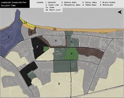
- City character : define different areas, how they are splitted in the city and analyse it with the potential it gives. So we can consider the areas and elements we can work with, the ones we have to improve and the ones we can for exemple change.
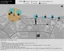
- Access to the lake : This is one the main aspect of the coastal analysis. All the coast along Kallaste has been analysed, how the access to the lake, which points of view, how easy it is to find it and how it is near the lake, the connection with the water.
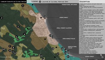
- Cultural layer : We also decided to add on a map with a smaller scale all the cultural spots around the city (the majority of the official cultural spots are not in the town) so we can also deal with the onion road and the give an story to the access to the city, so it will give even more value to the city. Moreover, the aborigines are getting old, so we need to protect their unique culture so we need recognition for it to be maintained even later.
-
-
-
-
add caption here
-
add caption here


C.4 References
- give a full list of the references you have used for this section
D. Process Reflection
- Reflect in your intercultural and interdisciplinary team on the outcomes of your study
- Which limitations were you facing?
- What have you learnt from each other?
- What would you do differently next time?
- You can also use diagrams/visuals
- 250 words text