Case Study E: Kopli liinid
>>>back to working groups overview
| Area | Kopli liinid | |
| Place | Tallinn | |
| Country | Estonia | |
| Topics | please enter the main coast-related topics here | |
| Author(s) | Kätlin Umal, Aurore Rabier, Irma Karic, Sarah Jankowski, Bine Schneider, Martina Palmiero, Pricop Alin, Najoua Saadi
| |

| ||
Rationale
- Why do you think this case is relevant? What is your hypothesis considering the landscape challenges?
- Format: 3-4 sentences
On the north-eastern side of Kopli peninsula in the north of Tallinn, lays the former village for the workers of the russo-baltic shipyard. It has with time declined and turned into a wasteland. For a time, it became a shelter for the poorest and an adventure terrain for photographs or young people that want to test their courage in the abandoned houses. However, nowadays, it seems that the influence of the Kalamaja district has came to Kopli lines, and that this former ghost-town will soon turn into a new trendy neighbourhood for families. The challenge is now to respond to the housing need while respecting the coastal ecosystem.
Location and scope
You can edit this map with the map editor
A Landscape System Analysis
A.1 Landscape layers and their system context
Geomorphology, landscape units and coastal typology
The coast of Kopli Liinid is characterised by hard rock sandstone cliffs and limestone steps, soft rock coasts and wave-dominated sediment plains, which are characterised by silty, sandy, gravel, pebble and boulder beaches, about half kilometer in length.

The landscape on the coast of Kopli Lines and it's neighbours
We can find more soft rock bluffs of Quaternary glacial drift deposit at Kopli, while more eroded hard rock sandstone cliffs and limestone steps can be found at Viimsi. The main type of sediment found on our coast at Kopli is what is typically found inside most of the bays, which is sand, but because of the lower width, there are numerous rocks and pebbles scattered around, making an especially scenic site. Here we can also see the general differences between the various coastal typologies that Estonia has to offer, compared to the different landscape that Finland has in store

Coastal typologies; A-foredune ridges plain, Harilaid, Estonia (Photo H. Tõnisson), B-erosion of low sandy coast at Kopli Liind site, Estonia (Photo H. Tõnisson), C-very narrow and low sandy coast on rocky basement, kiiu Abla, North from Tallinn, Estonia (Photo T. Łabuz), D-pocket beach with ephemeral embryo forms surrounded by rocky coast, Helsinki, Finland (Photo T. Łabuz). Link:https://www.researchgate.net/figure/Low-and-scarce-sandy-coast-in-North-east-part-of-Baltic-Sea-A-foredune-ridges-plain_fig8_324177287 .
Land use
The Kopli lines history was mainly influenced by Russia and the Soviet Union. Before the XXth century, it was a natural area, where fishermen established some settlements. In 1912, Russia decided to use Tallinn as a naval base, and started to build a shipyard on the Kopli peninsula. The Kopli lines were created at that time, as the village for the workers.
After the end of the Second World War, the shipyard was no longer for military purposes. Little by little, the wooden houses of Kopli lines have deteriorated and the neighborhood became a ghost town. The Kopli area is mainly a wasteland nowadays. Its reputation towards the Tallinn inhabitants is quite bad because some of the remaining houses are squatted, and many misadventure stories are told about this place. However, the character of the place and the heritage it’s showing are triggering some people’s interest.
But the tables seemed to have turned recently, when the company OÜ Fund Ehitus invested in that place. Inspired by the popularity of the Kalamaja district, they plan to build a whole new housing neighborhood, inspired by the previous planning of the worker’s village. They intend to give to the place its former function, but the character of the 'lines' might be lost in the process.

Kopli Lines main land-use in 2019

Kopli Lines: evolution of land-use
Green/blue infrastructure
- What are the major potential elements of a green/blue infrastructure network? Are these likely to change/disappear? Why is that?
- You find my background material on green infrastructure in our reading list
The KOPLI bay presents a generally green character and a relatively flat topography.
Reading the green infrastructure map allows us to identify three components:
- A park located in the south of the bay named Susta-Park, with an area of 8 ha. It's characterized by its landscape diversity with wetlands, wooded areas and rocks. - Areas of lawns, planted with small scattered trees, located mainly at the seaside and to the east. - Wooded wetlands, marked on the map in (blue-green)
As for the blue infrastructure of Kopli it consists of two elements; - The running water of the sea from a shallow depth of 0 to 5 m - Stagnant water, especially large wet spots punctuated on the site.
Today, the urbanization does not stop widening to the detriment of existing green spaces and fragment the space. The map shows that green spaces are fragmented.

add a caption

add a caption
Actors and stakeholders
The landscape changes are manly driven by the investors and the city, who have both high power.
Even though, mostly affected by the landscape changes are the squatters, which are currently the only inhabitants.
-
 Power map showing the stakeholders

Sacred spaces and heritage
- Which places/elements hold cultural value and to whom?
- You may add a map and some images, please also explain in your caption why these elements are valuable
The historical memory of Tallin is very interesting and complex. 1. One of the places with more historical value in the Kopli district is the Estonian Maritime Academy. The first maritime school in Estonia was founded in Tallinn in 1715. Tallinn Maritime School, whose successor is the Estonian Maritime Academy of TUT, was founded as one navigation class in 1919. At the same time, in 1920 he established the School of Marine Engineers in Tallinn and in 1935 was merged with Tallinn Marine School. On August 1, 2014, the Estonian Maritime Academy joined the Tallinn University of Technology as a college member and has been renamed TUT Estonian Maritime Academy.
2. Nikolai Kirik (church) is the remaining element of the sacred places of this area. Its purpose was to serve as spiritual guidance for the local community. It has been designed by Aleksandr Vladovsky in 1935. The building resembles Russian historical wooden architecture. With its architecture, it resembles the wooden house of the working class that lived nearby. The church is an inseparable piece of pre-war cultural environment of the seaside Kopli area in Tallinn.
3. Wooden houses are the cultural heritage elements of this area that represent one era for this place (until WWII). They have been built for the working class community where employees of Russo-Baltic Shipyard had all the essentials for their living. The architecture of these houses shows that the community lived simple and idyllic life next to its working place with the access to the beach.
4. The Rock of Kopli Park is a protected natural monument. The density and the size of the tip of the rocks are different in different parts of the park, the large boulders are close to each other. They create an unusual and very particular environment, and are important for Estonian natural history.
-
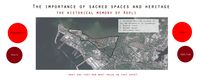 Map of sacred spaces and heritage
 -
 Nikolai kirik (church) and Wooden houses
 -
 Estonian Maritime Academy and Kopli Park


Visual appearance and landscape narrative
- Which elements are essential for the landscape character?
- Has the landscape been painted or otherwise depicted, when and whom? Which elements are essential?
- Which narratives exist? Who has written about this landscape or depicted it in some way?
- You can add text and images
The name of the peninsula comes from its past land use as a place for herding. Since then the eastern coastline has changed less than the western during the change from fishing village to industrial area with factories and supporting buildings. As the past functions are ended on the area the Kopli lines have since stayed in stagnation.
About the Kopli peninsula and its industrial past one can read in “Kopli sonata. The Russo-Baltic Shipyard.”
There are not many paintings of the area - neighboring areas with their rural/industrial settings have been inspiring more. There are but a lot of historical plans. And the site with its history and melancholy is inspiring a lot of photographers.
-
 Fisherman´s hut on the Kopli seashore by C. Fr. Chr. Buddeus (I half of 19th century)
 -
 grafiti in latin on a house waiting to be demolished
 -
 Plan of the Russo-Baltic shipyard from 1919-1920
 -
 Administrative building of the Russo-Baltic shipyard and the nearby barracks


A.2 Summary of your landscape system analysis and your development Targets

- You can summarize your findings with an DPSI(R) Model or a Spider Diagram
- Link back to the Sustainable Development Goals: Which goals are at risk?
If nothing is done for this area, the following goals of the European Union Sustainable Development Plan risk not to be fulfilled:
Goal 10-Reduced inequalities:
In the Kopli lines case, the driving forces are willing to give more power to a wealthier class, which goes against the pro-poor fiscal policies that the EU is trying to implement. There's also a gentrification risk.
Goal 13-Climate action:
The upcoming project proposed by OÜ Fund Ehitus, is planning to re-build houses near the coast line, not taking into account the flood risk that will increase with the climate change phenomenon. It's also disturbing the biodiversity which is already poor along the Tallinn coast (excepted the Natura 2000 area)
Goal 14-Life below water:
The upcoming project will also increase the population on the peninsula, which means more visits to the coast, and more risks of an increase of waste production that can end up in the sea.
Goal 15-Life on land:
The area of Kopli lines became a wasteland with time, which is a chance to develop an interesting ecosystem and reinforce the biodiversity. If this area is built up again, the vegetation dynamic will be stopped and highly reduced.
- What is your hypothesis for this landscape?
- Visualise your hypothesis with one graphic/pict

By following the current dynamics of the place, the coast aesthetic qualities and biodiversity will decrease,the population that visits the place will be less diverse, and the heritage of the place will be lost
- Are there any existing initiatives taking action in this landscape? Do you have a critical perspective on that?
- Add text and visuals
In 2016 a festival occured at the Kopli lines, except this and the housing programm, no actions were taken for this landscape. The existing actions are definitely moving forward to develop the city of Tallinn. However, this development may completely erase the history and heritage of the place.
A.3 Theory reflection
- Reflect on at least three international policy documents in relation to their local landscape case
- choose one international, one European and one national document
- You can choose references from our reading list
- Scope: 250 words
- European policy: Coastal Zone Policy
Included as a framework for Maritime Spatial Planning and Integrated Coastal Management the Coastal Zone Policy requires the EU Member States to provide a Strategic Environmental Assessment (Directive 2001/42/EC) in order to protect the natural resources and prevent the coastal risks. Our project site could reach the recommendations of the Integrated Coastal Management by promoting coastal tourism in our area. In order to reach the goals of the Maritime Spatial Planning, the site could also help the preservation, protection and improvment of the environment; improve the resilience to climate change impacts or promote a sustainable tourism.
- National policy (NATIONAL SPATIAL PLAN ESTONIA 2030+)
Estonia has a national spatial plan 2030+ dealing with the current issues in the country´s development and the measures that should be implemented by year 2030 in order to solve those issues. One of the main challenges is to assure that every settlement of Estonia becomes livable. The future development should focus on: improving the quality of everyday life concerning the residential situation, access to jobs and education in terms of public transport, improvement of regional and international transportation, energy management- production of sustainable energy, its storage and trade-, preservation and demarcation of landscapes that define Estonian identity… This plan represents the sum of general objectives that can be reinterpreted and put in the action on local level.
A.4 References
- give a full list of the references you have used for this section
-The last days of Kopli lines: https://www.muurileht.ee/galerii-kopli-liinide-viimased-paevad/?i=undefined
-{Forgotten Tallinn Series, Ep.3}~ Kopli Lines, Abandoned Ghost Town: http://hiddentallinn.com/kopli-lines/
-Surreal silence on Kopli routes: https://arileht.delfi.ee/news/uudised/fotod-surrealistlik-vaikelu-kopli-liinidel?id=77517004
-The construction company has started work on Kopli lines: https://arileht.delfi.ee/news/uudised/fotod-ja-video-ehitusfirma-on-kopli-liinidel-toodega-algust-teinud?id=73922113
-Stalker, a blog about abandoned world; Kopli Lines: https://abandonedme.com/2017/04/10/kopli-liinid/
-Kopli's lines have begun to change: https://arileht.delfi.ee/news/uudised/fotod-kopli-liinid-on-hakanud-muutuma?id=85348949
-Will this spring be the last of abandoned Kopli lines?: https://arileht.delfi.ee/news/uudised/fotod-kas-see-kevad-jaab-mahajaetud-kopli-liinidele-viimaseks?id=70981581
-Redging works on Kopli routes are in full swing, a beautiful seaside area is waiting for rebirth: https://www.delfi.ee/news/paevauudised/eesti/droonifotod-kopli-liinidel-on-lammutustood-taies-hoos-kaunis-mereaarne-ala-ootab-uuestisundi?id=78325775
-Long-awaited event. The first new house on Kopli's lines became a cornerstone: https://arileht.delfi.ee/news/uudised/fotod-kaua-oodatud-sundmus-kopli-liinide-esimene-uus-maja-sai-nurgakivi?id=82198117
-Kopli Lines: a new residential environment on the seashore: https://www.fundehitus.ee/kopliliinid/en/
-NATIONAL SPATIAL PLAN ESTONIA 2030+: https://eesti2030.files.wordpress.com/2014/02/estonia-2030.pdf
Phase B: Landscape Evaluation and Assessment
B.1 Assessment Strategy
- Based on the hypothesis derived from your previous landscape systems analysis you are now asked to define the goals for assessing the landscape. Your assessment is the basis for evaluating the landscape status.
- Which elements and phenomena need to be mapped, why and how?
- This a text contribution, max 250 words
B.2 Mapping
- As defined by your assessment strategy you conduct the mapping and present your findings here
- As a minimum, at least three different themes need to be mapped, you may choose more if needed
-
briefly explain the findings of your mapping
-
briefly explain the findings of your mapping
-
briefly explain the findings of your mapping
B.3 Problem definition and priority setting
- Give a summary of the major findings of your mapping process, what are the problems/potentials identified?
- Draw a problems/potentials map
- Set priorities for the most relevant issues
-
add caption here
B.4 Theory reflection
- Please reflect the assessment and evaluation methods used based on at least three readings
- Did you encounter limitations'
- 200 words test contribution
B.5 References
- give a full list of the references you have used for this section
Phase C – Strategy and Master Plan
C.1 Goal Setting
- Define strategic planning objectives based on the evaluation findings
- Link back to your original targets from section one and the Development Goals
- 150 words text contribution
C.2 Spatial Strategy and Transect
- translate your strategic goals into a vision
- develop a spatial translation of your vision
- exemplify your vision in the form of a transect with concrete interventions
- add map(s) and visualizations
-
add caption here
-
add caption here
-
add caption here
-
add caption here
C.3 From Theory of Change to Implementation
- For implementing your vision: Which partnerships are needed? Which governance model is required?
- Who needs to act and how? Draw and explain a change/process model/timeline
- Which resources are needed? On which assets can you build?
- add 150 words text and visuals
-
add caption here
-
add caption here
C.4 References
- give a full list of the references you have used for this section
D. Process Reflection
- Reflect in your intercultural and interdisciplinary team on the outcomes of your study
- Which limitations were you facing?
- What have you learnt from each other?
- What would you do differently next time?
- You can also use diagrams/visuals
- 250 words text