COLAND Case Study 2020 - Belgian Coast
>>>back to working groups overview
| Area | Belgian Coast | |
| Place | North Sea shoreline | |
| Country | Belgia | |
| Topics | Geographical cross-cutting; Sustainable housing; Green and blue infrastructure | |
| Author(s) | Andra Birica; Ruxandra Mihalcea; Alin Pricop; Ionela Popa; Mariana Bodea | |

| ||
Rationale
One of Belgium’s smaller regions is Flanders, which in turn brings a grand resource for the country: it’s serene coast towards the North Sea, with 68 km in lenght, consisting of a gently sloping sandy beach, backed by coastal dunes. With time, erroneous planning and climate change in the area made people realize of the long-term risks. Thus, we must adapt and correct the challenges of rapid urbanization, urban sprawl, erosion and the rising sea level, balancing and uniting 1- the protection of the cultural and natural heritage with 2- economical gains from the productive landscapes and tourism.
Location and scope
You can edit this map with the map editor
A Landscape System Analysis
A.1 Landscape layers and their system context
Geomorphology, landscape units and coastal typology
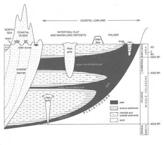
The Belgian coast consists of sandy beaches formed from thousands of years of interaction from natural factors, while in the interior landward area presents an intertidal flat, that has been developed through deposition of intermittent peat formations and fine-grained material. The study area is composed of a number of “belts”, the important ones for our study being the coastal dune belt and the coastal plain.
Geologically speaking, the present-day coastal barrier and plain were shaped very recently, in the Holocene period, between 10000 and 5000 years ago, when a natural rise of sea level took place from the melting of the Weichselian ice caps, rising up to 16 meters from 5000 years ago to this day.
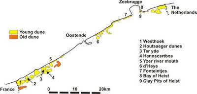
Our study area has a significant number of young dunes, being mainly located in the western side of the coast, where a more wild landscape is prevalent.
-
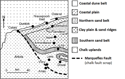 Geophysiographic sketch map showing the 'belts' https://www.researchgate.net/figure/Geophysiographic-sketch-map-showing-the-belts-of-northern-France-and-Belgium-based-on_fig2_226781223
 -
 Geomorphology https://journals.openedition.org/belgeo/15994?lang=nl
 -


Land use
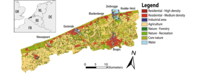
The study area is represented by a dense urban area that overshadows the natural landscapes that consists of dunes and beaches on the sea side, and with agriculture and forestry the more we go inland. This chaotic development between the two elements have threatened with time the coastline’s health through it’s severe fragmentation and erosion. What was a tidal landscape of dunes and meandering creeks, turned into a linear system with polders and a seemingly endless asphalt jungle along the increasingly eroded shore.
-
-
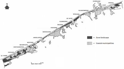 Dune landscape fragmentation due to urban sprawl http://biblio.naturalsciences.be/rbins-publications/miscellanous/faunal-inventories-of-sites-for-cartography-and-nature-conservation-proceedings-of-the-8th-international-colloqium-of-the-european-invertebrate-survey/faunal-inventories-of-sites-for-cartography-and-nature-conservation_177-187.pdf
 -
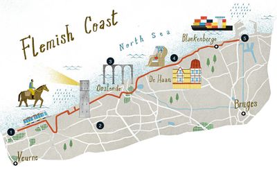 The flemish coast with it's attractions https://magazin.lufthansa.com/content/uploads/2016/10/Karte_Flandern_Zahlen-980x607.jpg


Green/blue infrastructure
- What are the major potential elements of a green/blue infrastructure network? Are these likely to change/disappear? Why is that?
- You find my background material on green infrastructure in our reading list
- add 1-2 graphical representations to the image gallery, you can add more if you like
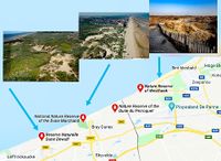
Green and blue infrastructure is particularly important because it has an impact on the environmental, social and economic level. This infrastructure can be encountered in various places, such as natural or semi-natural, urban, rural or marine areas. It can also include natural or man-made elements. On the Belgian coast the major potential elements of blue-green infrastructure network are represented by numerous natural and artificial parks, nature reserves and small lakes spread along the coastal area. Blue infrastructure is less represented than green infrastructure, meeting here Teteghem Lake, Spuikom, Vargeul, and other small lakes and canals.
The green infrastructure is represented by National Nature Reserve the Dune Marchand, Doornpanne Park, Maria Hendrikapark, Zeebos Park, Westhoek Nature Reserve, Sint-Pietersplas Park, Zwin Nature Park, etc., but also includes elements such as hedgerows, copses, bushes , orchards, woodlands, natural grasslands. Many of the natural parks have protection status and are integrated in the Natura 2000 Network due to the sand dunes and the special forests of the coastal area, among other elements of biodiversity. An important element of green infrastructure is agriculture, which covers an important area of the Belgian coast and which is essential for economic growth.
The main functions of the green-blue infrastructure are related to the conservation of biodiversity and the protection of ecosystems, the development of a sustainable economy and the promotion of health and wellbeing for the local communities, achieving a sustainable management of the area and maintaining a balance between the ecological functions and the multi-functional use of the lands.
All this elements representing the green and blue infrastructure are unlikely to disappear in the near future because most of them have natural landscape elements or represent important elements of the landscape, economy and society.
-
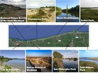 Green and blue infrastructure on the Belgian coast (Source: Google maps)

Actors and stakeholders
- The main actors who play an important role in the coast of Belgium are politicians (authorities), entrepreneurs (energy and maritime industry) naturalist (environmental protection) and local people.A considerable power and influence is exercised by the authorities and industry because they make decisions without implicating the other actors.Those who are affected but with the least power are the naturalists because the coast is in a continuous degradation (especially construction of polders and uncontrolled agriculture affects the environment). Local people are ignored and badly treated, they do not have power but are very affected by the decisions of the others actors involved in the development of the coast. The biggest changes in the Belgian coast are made by urbanization products because tall buildings are built quite close to the beach and invades the protected areas. The tourism in development has effects on the coast because it has a low quality. Tourists set up tents illegally in protected areas and pollute the environment, leaving waste behind.The main problems on the coast of Belgium are produced by the powerful actors and for this bad influence Belgium has adopted since 2009 Blue Growth, supported by the EU. Blue Growth focuses more on the economic development of all sectors on the coast and less on protecting the environment.
-
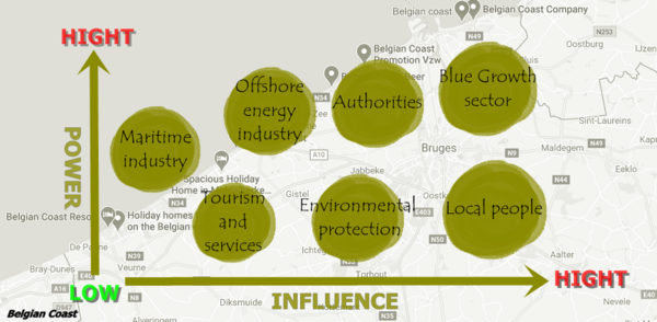 Belgian Coast Actors

Sacred spaces and heritage
- Which places/elements hold cultural value and to whom?
- You may add a map and some images, please also explain in your caption why these elements are valuable
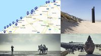
The coast of Belgium includes many heritage sites and areas of great historical importance, highlighted by statues, churches, memorial houses, forts, walkways, military vessels left over from activity, museums with special collections and many others. But the most representative element is a natural one, namely the sand dunes. Sand dunes have formed along the full length of the Belgian coastline (65 km) as a part of the dune barriers between Dunquerque (Northern France) and Denmark, originally covering over 6,000 ha. Today, only 3,800 ha of sand dunes remain, while nearly 50% of the coastline has been urbanised. The coast comprises a very gently sloping beach of fine sand backed by dunes generally less than 20m high, their width varying from a few kilometres (at De Panne and east of Knokke) to less than one hundred metres. They include Older Dunes of mid-Holocene age bordered and partly overlapped by Younger Dunes, which are still forming. The sequence is related to successive marine transgressions and regressions, during which a broad intertidal flat became bordered by barrier islands on which the dunes formed. The coast of Belgium has 9 natural dunes reserves, with approved management plans, but their implementation is blocked by the rapid development of road and tourism infrastructure. An important tradition included in the UNESCO list, which is still practiced today is Shrimp fishing on horseback in Oostduinkerke. In this 500-year-old tradition, shrimp fishermen dressed in yellow raincoats and high boots ride their horses breast-deep into the water at low tide. The horse pulls a net and drags a chain through the sand. Vibrations created by the chain rattle the shrimps into jumping into the net. The catch is then deposited into baskets fastened to the saddle. Horse-riding shrimpers demonstrate their craft during the annual Shrimp Festival of Oostduinkerke in the last weekend of June. The event, which attracts over 10,000 visitors a year, also features a shrimp parade and a shrimp catching contest for kids.
-
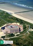 Fort Napoleon, 1811, Oostende
 -
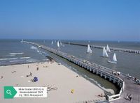 Mole Ooster (490 m) & Westerstakersel (543 m), 1865, Nieuwpoort
 -
 The map with natural reserves of dunes in Belgium
 -
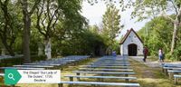 The Chapel ”Our Lady of The Dune”, 1720, Bredene


Visual appearance and landscape narrative
- Which elements are essential for the landscape character?
- Has the landscape been painted or otherwise depicted, when and whom? Which elements are essential?
- Which narratives exist? Who has written about this landscape or depicted it in some way?
- You can add text and images
Landscape character is defined as the distinct, recognisable and consistent pattern of elements in the landscape. It it these patterns that give each locality its 'sense of place', making one landscape different from another. Physical elements provide the fundamentally stable basic pattern of landscape, while cultural elements are superimposed on this and are more fluid, reflecting social and land use changes over time. Layered on top of this is the perceptual element – our own personal appreciation of landscape and how we relate to or make use of it, as individuals and communities.
An important project is taking place on the coast of Belgium, named Beaufort - an art project, triennial, in which the main role is played by the sea, an uncontrollable but unifying place. Every participating artist comes from a country that borders on the sea, which creates monuments that have different symbolisms, such as honoring characters who have made a significant contribution to society, illustrating tragic events or the connection between nature and man. The first edition of Beaufort took place in 2003 and was organised by then director of the Ostend Provincial Museum for Modern Art Willy Van den Bussche who would also remain the triennial’s curator in 2006. Monumental works found their place against the unique backdrop of the Coast, resulting in embodying the relationship between society and the environment and paying homage to both past times and events, as well as to the supremacy of the sea. For example, on the beaches of De Panne, Nieuwpoort and Oostende have been raised monuments that symbolize the power of people and nature. "Three Wise Noses of De Panne” are part of a tradition of realistic public sculptures that have a heroic function, like the Statue of Liberty in New York Harbor, the Cristo Redentor in Rio De Janeiro or the ancient Colossus of Rhodes. They stand there as protectors or guardian angels of all seafarers, as symbolic defenders of a harbour or coastal city. They are statues that initially served as a welcome beacon or signpost, and over time have become tourist attractions, no longer just a waymark but a destination in their own right. "Men" is an equestrian sculpture that is part of an ancient Belgian tradition of placing equestrian monuments on the coast. Men on horses represent power and war. By putting them in the unusual setting of the sea and echoing the motif, the element of prestige is replaced by drama, and the statues look as if one moment in a forgotten battle at sea has been cast in bronze. This allusion to an army absurdly draws lines across time and place, as the statues disappear and reappear with the tide. A daily vanishing ritual as the ocean slowly swallows the sharp edges of the sculptures until they eventually disappear into anonymity. The "Monument for a Wullok" is a monument to the sea, and ode to its power and indomitable nature, and to the secrets that it refuses to reveal. The bronze thus acquires a brownish-green pockmarked surface which contrasts with the soft, smooth and accessible inner side, in which as children we thought we could hear the sound of the sea. The coast of Belgium has been immortalized in postcards since 1926, but also in books describing both the historical events in this area and its tourist secrets.
-
 The map with Beaufort locations and monuments, 2018
 -
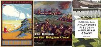 Postcard and books about Belgian coast


A.2 Summary of your landscape system analysis and your development targets
- Tourism, urbanization, maritime activity, climate change, industrialization are the main drivers on the Belgian coast. That driver is exerting pressure on the area. The results of these pressures can be considered negative because there are effects such as the increase of the water level, the geophysical pressure, the deterioration of the environment, the popularity of the area. Also, there are effects on the environment, such as erosion of shoreline, flooding area, pollution (air by industry, audio by construction of various buildings, environment by tourism, and water by maritime industry). All this force has a negative impact, so the quietness of place disappears, land and water are damaged, and biodiversity will lose and decline in the quality of life.To stop the negative impact on the Belgian coast we thought that the Belgian state could have the following answers to the problems: a biodiversity strategy resulting by creating an integrated coastal management, environmental policy an efficient nature protection and conservation plan, strict application of structural plans and rules, nature restoration (integration of coast and polder) and strict control of tourism.
- Link back to the Sustainable Development Goals: Which goals are at risk?
- What is your hypothesis for this landscape?
- Visualise your hypothesis with one graphic/pict
- Are there any existing initiatives taking action in this landscape? Do you have a critical perspective on that?
- Add text and visuals
-
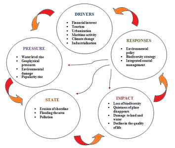 System Analysis of Belgian Coast

-
explain your hypthesis briefly in the caption
A.3 Theory reflection
- Reflect on at least three international policy documents in relation to their local landscape case
- choose one international, one European and one national document
- You can choose references from our reading list
- Scope: 250 words
As the area is characterized by rapid urbanization as a consequence of population growth, the Belgian coast faces challenges such as climate change, economic development, demographic changes and environmental resource management. Climate change is already affecting the marine environment and will continue to trigger changes in biological, chemical and physical processes. Such changes can reduce the ‘ecosystem resilience’ (i.e. the ability of an ecosystem to persist despite disruption and change) to other man-induced pressures, leaving ecosystems increasingly sensitive to disruption. Impacts include rising sea levels, increased sea temperatures and precipitation changes. The New Urban Agenda as guidance for further integrated urban development can facilitate mitigation of the problems such as urban sprawl, losing the identity of the space, unsustainable resource use and lack of participation, mainly through the dialog between multi-stakeholders (public and private sector, working with civil society).
In 2000, Florence was the host of the European Landscape Convention, which recognized the importance of the landscape, defining it as part of the lands perceived by both locals and visitors and evolving over time as a result of natural forces and human actions. The purpose of the convention was to promote the protection, planning and management of European landscapes and to establish a form of cooperation on landscape issues. Another key aspect of the convention is that it assigns an active role to the public in terms of landscape perception and evaluation. The public should be directly involved, not just specialists, therefore, the objectives regarding the quality of the landscape are set by the aspirations of the public and by the characteristics of the landscape, surroundings that are formulated in addition by the competent authorities. In our case, Belgian coast has all kinds of landscapes whose importance has been recognized by this convention.
In 2010, Belgium adopted its National Adaptation Strategy which describes the main climate change impacts, the existing adaptation responses, a roadmap to a future National Adaptation Plan (NAP) and several policy guidelines for the further development of adaptation policy. The Strategy has 3 objectives: improve consistency between existing adaptation activities in Belgium (evaluation of the impacts of climate change, vulnerability to climate change and adaptation measures already implemented); improve communication at national, European and international levels; initiate a process for the preparation of a national action plan. The Belgian National Adaptation Plan targets the years 2017-2020 and proposes a set of national measures focused on adaptation to climate change.
A.4 References
- give a full list of the references you have used for this section
- https://www.google.ro/maps/@51.1937049,2.727344,63300m/data=!3m1!1e3
- http://chapter.ser.org/europe/files/2012/08/Coastal.dunes_.Westhoek-2008-excursion.pdf
- https://ec.europa.eu/environment/nature/ecosystems/docs/green_infrastructure_integration.pdf
- https://ec.europa.eu/environment/nature/ecosystems/docs/Green_Infrastructure.pdf
- http://bioveins.eu/blog/article2
- https://www.beaufort2018.be/en
- https://www.beaufort2018.be/en/artworks
- https://www.belgiancoast.co.uk/en/do/culture-heritage
- http://www.worcestershire.gov.uk/info/20014/planning/1006/landscape_character_assessment
- https://www.climat.be/files/4214/9880/5755/NAP_EN.pdf
- http://www.flanderstoday.eu/current-affairs/climate-change-requires-radical-plan-flemish-coast
- http://landezine.com/
- Geldof, Charlotte and Zaman, Jan (2015) Some Futures for the Belgian Coast 2100, a Case Study of Research by Design on Regional Level. REAL CORP 2015
- https://brussels-express.eu/13-fascinating-belgian-traditions-recognized-as-unesco-cultural-legacies/
- http://www.coastalwiki.org/wiki/Sand_dune_-_Country_Report,_Belgium
Phase B: Landscape Evaluation and Assessment
B.1 Assessment Strategy
- Based on the hypothesis derived from your previous landscape systems analysis you are now asked to define the goals for assessing the landscape. Your assessment is the basis for evaluating the landscape status.
- Which elements and phenomena need to be mapped, why and how?
- This a text contribution, max 250 words
B.2 Mapping
- As defined by your assessment strategy you conduct the mapping and present your findings here
- As a minimum, at least three different themes need to be mapped, you may choose more if needed
-
briefly explain the findings of your mapping
-
briefly explain the findings of your mapping
-
 briefly explain the findings of your mapping

B.3 Problem definition and priority setting
- Give a summary of the major findings of your mapping process, what are the problems/potentials identified?
- Draw a problems/potentials map
- Set priorities for the most relevant issues
-
add caption here
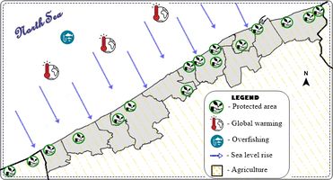
Although the Belgian coastal zone is small, it comprises several types of coastal habitats (sandy beaches, intertidal salt marshes, sand dunes and salt polder meadows) and is a densely populated area and hence a very intensively used zone with important economic and tourist activities. Furthermore, the Belgian Part of the North Sea (including the exclusive economic zone) is characterized by high productivity, but also by dense shipping traffic, intensive fisheries, tourism, the presence of cables and pipelines, sand and gravel extraction, dredging activities, and offshore wind turbine parks. These activities have resulted in a qualitative and quantitative degradation of the coastal ecosystem. The main problems of the Flemish coast are classified into 4 categories: Climate change, Loss of biodiversity, Tourism growth and Development of coastal cities.
- Climate change affects the coast through advanced erosion, sea level rise, extreme weather events that cause flooding.
- The loss of biodiversity is mainly the cause of the protection measures taken by the authorities through the construction of the dams, but also a cause of urban overdevelopment, of the tourism in a chaotic way, of the constructions in the protected areas.
- The Flemish coast is the most popular holiday destination in the country, therefore, it greatly affects the coastal area, due to the fact that many tourists cross the beaches destroying dunes, throwing waste and polluting. Also, for a pleasant stay, the authorities are building access roads, beach bars and other tourist structures that destroy habitats.
- Due to the high demand of tourists to spend their holidays in the Flemish coastal area, the coastal cities have developed considerably, occupying more and more of the natural areas and building accommodation, recreation and parking spaces and landscaping. golf.
Regarding the potential of the Flemish coast, it consists of the diversity of cultural tourist attractions (statues, museums, exhibitions, unique and unique monuments), social (festivals, concerts), sports, culinary, but also in the large number of different tourist structures. vacation packages and relaxation opportunities. The main motivation for a coastal visit is to relax (48%) and enjoy the healthy sea air (45%). In terms of activities, strolling on the dike (70%), visiting cafes, tea rooms, terraces (57%) and visiting restaurants (44%) Moreover, the Belgian coast is popular with water sports enthusiasts.
B.4 Theory reflection
- Please reflect the assessment and evaluation methods used based on at least three readings
- Did you encounter limitations'
- 200 words test contribution
B.5 References
- give a full list of the references you have used for this section
Phase C – Strategy and Master Plan
C.1 Goal Setting
- Define strategic planning objectives based on the evaluation findings
- Link back to your original targets from section one and the Development Goals
- 150 words text contribution
C.2 Spatial Strategy and Transect
- translate your strategic goals into a vision
- develop a spatial translation of your vision
- exemplify your vision in the form of a transect with concrete interventions
- add map(s) and visualizations
-
add caption here
-
add caption here
-
add caption here
-
add caption here
C.3 From Theory of Change to Implementation
- For implementing your vision: Which partnerships are needed? Which governance model is required?
- Who needs to act and how? Draw and explain a change/process model/timeline
- Which resources are needed? On which assets can you build?
- add 150 words text and visuals
-
add caption here
-
add caption here
C.4 References
- give a full list of the references you have used for this section
D. Process Reflection
- Reflect in your intercultural and interdisciplinary team on the outcomes of your study
- Which limitations were you facing?
- What have you learnt from each other?
- What would you do differently next time?
- You can also use diagrams/visuals
- 250 words text