Algarve
>>>back to working groups overview
| Area | Praia da Rocha | |
| Place | Portimão | |
| Country | Portugal | |
| Topics | Coastal Management | Risk | Tourism | |
| Author(s) | Tatiana Nascimento | |

| ||
Rationale
The tourism boom that happened during the last century in the south coastal area in Portugal, in this case of study the Praia da Rocha "Stone's Beach" in English, obligates to an artificial increasing of the coastal sand terrain. According to the theme of coastal landscapes, it's important on this case of study: To understand how the coastal zone of Praia da Rocha is managed, which has evolved exponentially since the last century; The risk that may be implicit in depending on this management as to the singularity of the place.
Location and scope
A Landscape System Analysis
A.1 Landscape layers and their system context
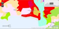
Geomorphology, landscape units and coastal typology
- Beach supplied by sedimentary exchange with the submerged delta bank of the Arade River
- Beach Artificial Nourishment
- Coastal Zone - Beach composed by landforms as rock cliffs, caves, arches, and stacks
-
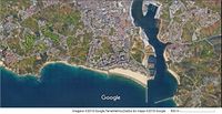
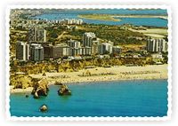 Praia da Rocha, 1970
 -
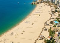 Praia da Rocha, Current


Land use
- Ends of XIX century this coastal zone was a small village with agriculture as main activity, some small business commerce and recreation, where the Casino had a big amount of profits. Then a big investment has made this zone developed with a tourism related vision. So the small village turned a urban centre with lots of tourists at the Summer season. The upgrade in the commerce and recreation, makes the tourism boom in this region that developed without management.
-
 1990
1990 -
 2000
2000 -
 2012
2012 -
 Legend


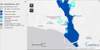
Green/blue infrastructure
- Elements:
Praia da Rocha is the strip of sand that has tendency to disappear because of the coastal erosion.
The agriculture fields on the green infrastructure have tendency to disappear to be converted in tourism resorts or building areas.
-
 Satellite View
 -
 Water & Wetness
 -
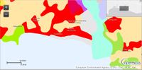
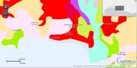
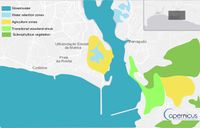 Green/Blue Infrastructure


Actors and stakeholders
- The coast is mainly owned by tourism companies and is ruled by a speacial law: the Coastline Planning Plan Brunau-Vilamoura (POOC Brunau-Vilamoura). Residents are the most affected by any changes in the management of this place and tourists are affected but they still have some power by their choices to make changes on the development of the coast.
-
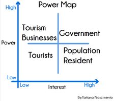 Power Map - Tourism

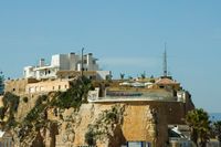
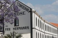
Sacred spaces and heritage
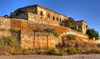
- Santa Catarina Fortress - a dominant position on a hill at the eastern end of Praia da Rocha, near the Arade River, this fortification defended the town and the Arade River bar cooperating with the Forte de São João do Arade on the opposite bank of the river in Ferragudo. During the Philippine Dynasty, this fort was built during the reign of Philip III, in the place where there was already a chapel dedicated to St. Catherine of Alexandria, which still remains the primitive Gothic portal inside. With the earthquake of 1755, this fortification suffered heavy damage. In the twentieth century it was occupied by the Maritime Police and the Fiscal Guard, and also served as a restaurant, café and ice cream parlor. Currently the strong dependencies are used as a place of leisure for tourists who demand the Praia da Rocha and the adjacent Marina of Portimão.
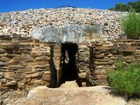
- Place Alcalar – about 5,000 years, a prehistoric community settled and lived in this place, which established a village defended by walls, trenches and embankments, built homes, from which they built an important set of megalithic tombs. The remains found allow to know their way of life, his activities, of the occupation and use of this place. The relationship with death is reflected in the forms of construction of different types of tombs from the mass graves to the specially intended for heads and their families. Discovered and explored since the late nineteenth century, the megalithic monuments of Alcalar are classified as National Monument. Alcalar, two of these funerary monuments are open to the public and allow a direct contact with the processes and materials used in its construction.
- School Farm – one rapprochement space to the countryside, experience and values of rural areas as important for the growth of an urban population increasingly away from this reality. This farm brings to the city all that the field is good, all his teachings, all their life experiences.
- Portimão Museum – to observe closely some of the original parts, found in different monuments and the village, thus achieving a better understanding of the cultural legacy of this ancient community. To discover and get to know more about the life of these communities in prehistory, this museum has prepared a diverse set of activities: both guided tours a day in Pre-history; Sounds of nature; Hunters of prehistory; Builders of monuments; Pottery / Soenga; Weaving; Whittle Stone; Milling; Alcalar Interpretation Centre.
- Convent of São Francisco or Convent of Nossa Senhora da Esperança – former Franciscan convent of the sixteenth century, Manueline and Mannerist style, situated along the Arade river in the city of Portimão and currently is in a state of degradation. Founded in 1530 by Simon Correia, captain Azamor and important figure of the Algarve in the sixteenth time, this convent was born in a house donation made to the Observant Friars of the Franciscan Province of Portugal. Still unaware of the early life of this religious institution, since the establishment of the brothers just happened in 1541 given some divergences within the peninsular Franciscans. However, parish records archive 1734 allow to conclude that the convent building works began soon after its founding. In those same records relates that when the first friars arrived at the scene, found the church ever built; on the other hand, on the main entrance of the building there was a coat with the arms of Simão Correia, proving the personal commitment of the settlor in the building of the monastery complex. In the earthquake of 1755 took place the first great moment of destruction of the building, with the collapse of the church dome and numerous convent buildings, which led to the temporary transfer of the religious community to the Church of the Holy Body. Soon after the extinction of religious orders, the convent now has several functions that nonreligious, all of which contributed to its slow destruction. This convent has been classified as a Public Interest Property by IGESPAR.
- Castle of Alvor – also called Albur Castle or Fortress of Alvor, this is located in the village and the town of Alvor, Portimão county. In a dominant position on a hill, opposite the Atlantic Ocean, it is considered a significant military monument in the Algarve, with its history associated with the neighboring Silves Castle. A recent archaeological research, showed a primitive human occupation through an important pre-Roman fortified shopping center, which maintained its activity during the Roman occupation and after. At the time of Muslim occupation, the defensive system of the town deepened, although not yet fully understood by scholars: the defense provided by the Moorish castle was reinforced by complementary strongholds, between it and the sea. In the context of the campaign of conquest of Silves, D. Sancho I of Portugal tried taking Alvor since 1187. As later with the strengthening of a Crusaders armed from Denmark and Friesland who attacked and conquered the Castle of Alvor, anticipating the siege and taking of Silves Castle, depending on who enroll. The position of Silves was held by Christians until 1191. Although it has remained one of the main towns in the Algarve, due to the excellence of its cove here and died King John II, they were not found information about the evolution of military architecture the village and its castle. At the time of the Philippine Dynasty, the passage of the sixteenth century to the seventeenth, in the context of conflicts between Spain and the northern powers, the Algarve sea fortifications were modernized and strengthened. About Alvor, Alexandre Massai, Neapolitan military engineer in the service of Spain, said his defense was ineffective on the capacity of the artillery of the time, which contributed to the abandonment of the structure in favor of new fortifications, forces concentrators at points- keys of the south coast of Portugal. Faced with the loss of its defensive function, the castle was gradually surrounded by the town growth over the centuries, it has been falling in ruins. In the late twentieth century, the castle was classified as a Public Interest in 1984, and was turned into a children’s garden, commemorating the Christian conquest of the town.
By:holidaysportugal.eu
-
 Santa Catarina Fortress
 -
 Museum of Portimão
 -
 Place of Alcalar
 -
 Convent of São Francisco
 -
 School Farm
 -
 Alvor Castle


Visual appearance and landscape narrative
- Special elements: rocks, sand and sea
- The Legend of Praia da Rocha
There was a mermaid that, it is not well known how it ended up on the great rocks of a sandy tongue on the Algarve coast. There she rested for a long trip to enjoy the beautiful landscape from the top of each rock road. Until one day she heard someone coming, and waking up she saw an old man claiming to be a son of the sea. He said that all that water, from there to the edge of the horizon and even to the oceanic realms beyond what the eye could see was his. And so in love was the mermaid that if she accepted marriage, he would share this aquatic kingdom with her. Forever. The mermaid was preparing to respond, but at that moment another old man came, coming from the continental side. He said that he was the son of the Hills, and that the territories that remained north of the cliff, and that went up to the hills were his property. That if he left the son of the Sea and accepted him instead, all the flowers and shrubs and trees and hills and valleys could be gardens of his own. The Mermaid did not know what to do and let them both compete for their love. And so it was. For centuries: the Sea seduced with its rippling and the movement of each tide, the mountain with its fruits and flowers. And it all lasted a long time. so much so that the mermaid was turned into fine sand and the two suitors maintained their game of forces and truces. Now pushing himself or herself by helping each other forming what we know today by Praia da Rocha. It is interesting to note as the legend, although it isn't just that, it hides a scientific side - the fact that a beach is built by erosion caused between land and sea (and wind, already). In this case decorated it with a third party, the mermaid, a reference of national folklore, especially in the Portuguese coast. Is that, curiously, is also a symbiosis of these same elements (the half woman representing the land and the half fish representing the ocean). From www.portugalnummapa.com/praia-da-rocha adapted
-
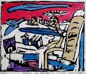 Jason Berger
 -
 Jason Berger
 -
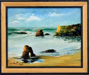 Gustavo Ferreira
 -
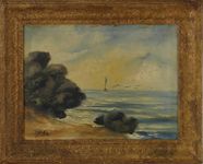 P.Marks


A.2 Summary of you landscape system analysis and your development Targets
-
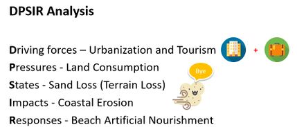 The urbanization necessary for tourism boom that occured in Algarve coast needed more land consumption, or in this case sand terrain, to develop. But the external natural force, in this case sea and wind, makes the coastal erosion a problem to face. Nowadays, the response is beach artificial nourishment. But this is a short-term solution with big impact on the economy and in the landscape...


The tourism boom that this beach had, obligates to an artificial increasing of the coastal sand terrain.
In this case of study, I want to understand how the coastal management affects the visual quality of this landscape.
A.3 Theory reflection
Goal 11: Make cities inclusive, safe, resilient and sustainable. From United Nations Sustainable Development Goals
From this goal, is visible that the response of artificial nourishment isn't a sustainable solution for the future. That's why it's important to see which solutions can be applied to help this landscape to be sustainable in a long-term.
It is the biggest maritime sector in terms of gross value added and employment and, according to the Blue Growth StudySearch (...), is expected to grow by 2-3% by 2020. From European Commission Maritime Spatial Planning European Strategy for more Growth and Jobs in Coastal and Maritime Tourism
Tourism is expected to grow, and with the quantity that we have until now, that's lots of it, it will reach a maximum limit of land consumption. So it's necessary to see how is this progression changing the landscape and the risk of continuing expanding.
Genuinely sustainable development depends on appropriate long-term management and maintenance of the site’s assets, including the GI. From Landscape Institute. Green Infrastructure: An Integrated Approach to Land Use. Position statement, 2013.
In this sentence is explicit the need of integrate both, blue and green infrastructure, for a sustainable development. In POOC Burnau-Vilamoura, we already integrate the biodiversity and protected some risk areas but still, it needs to be consider, how the visual quality of the landscape is being developed and how this affects for the future generations.
A.4 References
- Praia da Rocha (Portugal): an anthropization paradigm of the Algarve coast, J. A. Dias, IELT – Instituto de Estudos de Literatura Tradicional, Faculdade de Ciências Sociais e Humanas, Universidade Nova de Lisboa, 1069-061 Lisboa, Portugal.,CIMA – Centro de Investigação Marinha e Ambiental, Universidade do Algarve, Edifício 7, Campus de Gambelas, 8005-139 Faro, Portugal.
- http://www.portugalnummapa.com/praia-da-rocha/
- https://holidaysportugal.eu/algarve/en/heritage-portimao/
- United Nations. Sustainable Development Goals (SDGs)
- European Commission Maritime Spatial Planning European Strategy for more Growth and Jobs in Coastal and Maritime Tourism
- Landscape Institute. Green Infrastructure: An Integrated Approach to Land Use. Position statement, 2013.
- http://www.apambiente.pt/_zdata/Ordenamento/Algarve_POOC%20Burgau%20Vilamoura/1.Regulamento.pdf
Phase B: Landscape Evaluation and Assessment
B.1 Assessment Strategy
- Regulatory review for the uses of the beach.
- Valorization and qualification of the beach in the tourist and environmental surroundings.
- The orientation of the development of the activities in the coastal zone.
- These goals have the relationship whit the thematic of a risk of losing sand (land) and loss of identity by human exposure.
- The tourism, economic activities (fishery), and natural water spaces.
B.2 Mapping
-
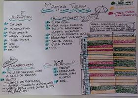 Mapping Turism
 -
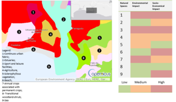 Mapping Natural Spaces
 -
 Mapping Fishery


B.3 Problem definition and priority setting
- The main problem that are found on this area are: Lack of opportunity for fishing activity to develop sustainably due to lack of enforcement and increased illegal activity that minimize populations of different marine species; Although the law protects the cliffs and the coastal zone, does not specify what the landscape is to protect in that area, that is, a breach in the law that can easily be shaped by large tourism companies, Also the fact that the population of the urban center is spandir to the coast is a factor to be taken into account in this evaluation because it demonstrates the loss of natural area previously used for the agricultural activity for the continuous waterproofing of the soils and the continuous modification of the identity of that one area.
- Priorities and Targets: To reconcile future urban, tourist and equipment occupations with the natural, cultural, landscape and risk factors, proposing safeguard measures according to the Landscape Architecture.
-
add caption here
B.4 Theory reflection
- Please reflect the assessment and evaluation methods used based on at least three readings
- Did you encounter limitations'
- 200 words test contribution
B.5 References
- "POOC Vilamoura-Vila Real de Santo António, 121/27 July 2005"
Phase C – Strategy and Master Plan
C.1 Goal Setting
- Define strategic planning objectives based on the evaluation findings
- Link back to your original targets from section one and the Development Goals
- 150 words text contribution
C.2 Spatial Strategy and Transect
- translate your strategic goals into a vision
- develop a spatial translation of your vision
- exemplify your vision in the form of a transect with concrete interventions
- add map(s) and visualizations
-
add caption here
-
add caption here
-
add caption here
-
add caption here
C.3 From Theory of Change to Implementation
- For implementing your vision: Which partnerships are needed? Which governance model is required?
- Who needs to act and how? Draw and explain a change/process model/timeline
- Which resources are needed? On which assets can you build?
- add 150 words text and visuals
-
add caption here
-
add caption here
C.4 References
D. Process Reflection
- Reflect in your intercultural and interdisciplinary team on the outcomes of your study
- Which limitations were you facing?
- What have you learnt from each other?
- What would you do differently next time?
- You can also use diagrams/visuals
- 250 words text