Uncategorized files
Jump to navigation
Jump to search
Showing below up to 50 results in range #1,151 to #1,200.
-
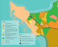
 LANDUSE 06.jpg 1,234 × 951; 275 KB
-
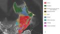
 LAND USE.jpg 1,634 × 2,001; 500 KB
-
 LAND USEOK.jpg 2,059 × 2,001; 625 KB
-
 LAND USE 2.jpg 2,059 × 2,001; 704 KB
-
 LAST VIEW.jpg 1,774 × 1,181; 1.26 MB
-
 LCA1.jpg 913 × 747; 219 KB
-
 LCA2.jpg 913 × 747; 267 KB
-
 LCAJPG.jpg 2,391 × 1,350; 814 KB
-
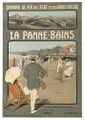 La Panne Bains.jpg 355 × 500; 198 KB
-
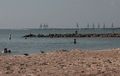 La Porte Beach.jpg 341 × 217; 21 KB
-
 Lac-Tasaul-ww.jpg 460 × 360; 93 KB
-
 Lacada Point near Giant's Causeway.jpg 1,024 × 683; 211 KB
-
 Lacul Limanu.jpg 1,000 × 631; 406 KB
-
 Lacul siutghiol 01.jpg 440 × 293; 45 KB
-
 Lahemaa.JPG 937 × 359; 58 KB
-
 LahemaaGeomorphology.jpg 2,267 × 3,206; 1.56 MB
-
 Lahemaa kaart.JPG 967 × 699; 124 KB
-
 Lahemaa matkarajad.JPG 784 × 553; 112 KB
-
 Lahemaa soode kaart.JPG 808 × 486; 87 KB
-
 Lahemaacastle.jpeg 1,171 × 665; 278 KB
-
 Lakepeipsibye.JPG 987 × 739; 81 KB
-
 Lakeperso compressed page-0001.jpg 1,754 × 1,241; 1.52 MB
-
 Land-use map.png 3,511 × 2,047; 1.51 MB
-
 LandUse.jpg 4,963 × 7,811; 1.76 MB
-
 LandUse map.PNG 2,528 × 1,490; 1.62 MB
-
 Land 60 1.jpg 1,463 × 835; 197 KB
-
 Land Use 10000.jpg 1,418 × 1,418; 1.04 MB
-
 Land Use 2012 Legende 0.jpg 773 × 513; 303 KB
-
 Land cover.jpg 1,618 × 2,128; 434 KB
-
 Land today.jpg 1,463 × 835; 325 KB
-
 Land use.jpg 1,507 × 1,579; 1.89 MB
-
 Land use2.JPG 738 × 933; 129 KB
-
 Land use 1.jpg 619 × 862; 292 KB
-
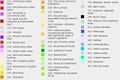
 Land use 1990.jpg 1,846 × 989; 329 KB
-
 Land use 2.jpg 618 × 866; 269 KB
-
 Land use 2017.JPG 634 × 558; 108 KB
-
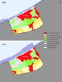
 Land use 2018.jpg 1,846 × 989; 329 KB
-
 Land use 23August 1.jpg 747 × 1,361; 1.94 MB
-
 Land use 23August 2.jpg 990 × 659; 142 KB
-
 Land use 23August 3.jpg 1,024 × 683; 126 KB
-
 Land use 23August 4.jpg 800 × 533; 140 KB
-
 Land use Fardokht and Yasaman.jpg 960 × 720; 133 KB
-
 Land use Fardokht and Yasaman .jpg 960 × 720; 100 KB
-
 Land use Mongte di Procida.png 3,508 × 2,374; 206 KB
-
 Land use Monte di Procida 1.jpg 3,508 × 2,374; 149 KB
-
 Land use RO.jpg 889 × 1,088; 1.8 MB
-
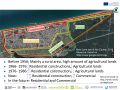
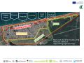
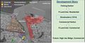 Land use and its development story.jpg 1,754 × 897; 942 KB
-
 Land use b2.jpg 976 × 772; 618 KB
-
 Land use changes.jpg 1,378 × 585; 632 KB
-
 Land use existant 2019.jpg 1,203 × 1,043; 365 KB


