Unused files
Jump to navigation
Jump to search
The following files exist but are not embedded in any page. Please note that other websites may link to a file with a direct URL, and so may still be listed here despite being in active use.
Showing below up to 50 results in range #201 to #250.
-
 Sacred spaces and heritage.jpeg 3,471 × 2,603; 654 KB
-
 Herritage ValuableElements Tallinn.jpg 1,500 × 1,000; 534 KB
-
 Rione-terra powermap.jpg 2,083 × 798; 1.31 MB
-
 Bvuh.png 842 × 469; 316 KB
-
 Coland tallinn 3 Page 11.jpg 5,920 × 4,440; 1.3 MB
-
 Coland tallinn 3 Page 03.jpg 2,430 × 1,823; 346 KB
-
 Coland tallinn 3 Page 02.jpg 2,000 × 1,500; 220 KB
-
 MerimetsaDPSIRmodel.jpg 3,000 × 2,250; 1.9 MB
-
 Coast text.png 1,865 × 575; 1.98 MB
-
 1822fin.jpg 1,293 × 2,308; 188 KB
-
 Sacred Spaces and Heritage.jpeg 5,068 × 5,295; 1.59 MB
-
 Ipogei del Fondo Caiazzo.jpg 328 × 500; 28 KB
-
 Grenne and bleu Infrastructure.jpeg 4,335 × 2,567; 908 KB
-
 Stadio di Antonino Pio.jpg 774 × 581; 1.99 MB
-
 Location of the area.JPG 624 × 593; 87 KB
-
 Location of the area-color.jpg 418 × 391; 87 KB
-
 Location of the area-Color.jpg 418 × 391; 87 KB
-
 Impact.jpg 6,442 × 2,545; 737 KB
-
 System ANalysis Baia.jpeg 1,207 × 784; 308 KB
-
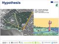
 Baia Hypothesis.jpeg 1,995 × 1,164; 748 KB
-
 Narges pic1.jpg 651 × 599; 80 KB
-
 Green areas plan city context.jpg 5,669 × 4,318; 1.89 MB
-
 5 Road Connection upload.jpg 3,121 × 3,121; 1.5 MB
-
Green islands beschriftung.png 3,898 × 3,898; 801 KB
-
 Green islands beschriftung 1.jpg 3,898 × 3,898; 527 KB
-
 Geologysection.png 1,282 × 754; 97 KB
-
 Architecture plan.jpg 1,111 × 1,106; 277 KB
-
 Pelguranna powermap2.png 1,182 × 664; 103 KB
-
 Landuse Buildings.jpg 842 × 596; 114 KB
-
 Dpsi scheme.jpg 3,450 × 1,893; 795 KB
-
 Scheme Natura 2000 rogné.jpg 1,191 × 607; 58 KB
-
 Scheme Natura 2000.png 1,191 × 842; 26 KB
-
 Scheme Natura 2000 V2.jpg 2,190 × 736; 109 KB
-
 Naples 6 Land use changes.jpg 8,185 × 2,934; 1.25 MB
-
 Water infra.jpg 14,629 × 11,198; 1.95 MB
-
 Water infra EK.jpg 14,629 × 11,198; 1.95 MB
-
 Green EK.jpg 2,790 × 2,967; 1.03 MB
-
 Water EK.jpg 2,790 × 2,967; 826 KB
-
 DPSIR MERIMETSA-STROOMI.jpg 3,000 × 2,136; 1.89 MB
-
 Power map.jpg 3,508 × 2,480; 791 KB
-
 67AA2DC5-CAF5-48A1-B38C-C6CEA6D16F9A.jpeg 1,298 × 1,720; 299 KB
-
 Kopli lines sacredspace map1.jpg 3,508 × 1,416; 1.4 MB
-
 WaterEK.jpg 2,790 × 2,967; 527 KB
-
 Mapping Rionne Terra 2.jpg 3,776 × 2,040; 1.63 MB
-
 H IT.png 3,512 × 3,064; 1.63 MB
-
 M&POP port area - wiki.jpg 1,367 × 961; 427 KB
-
 M&POP green area- wiki.jpg 1,369 × 959; 423 KB
-
 190501 Risk and Potentials wiki.jpg 3,508 × 2,480; 472 KB
-
 190501 Risk and Potentials.jpg 3,508 × 2,480; 472 KB
-
 Greens large scaleJPG.jpg 2,677 × 1,377; 1.26 MB


