COLAND Case Study 2020 - Dunkerque (East)
>>>back to working groups overview
| Area | Dunkerque (East) | |
| Place | Dunkerque | |
| Country | France | |
| Topics | Environmental Heritage - Tourism and Commerce - Land Consumption | |
| Author(s) | Ambrosino Mara, Guerra Antonio, Hassler Alessandra, Savelli Giulia, Scoppola Pietro | |

| ||
Rationale
- Why do you think this case is relevant? What is your hypothesis considering the landscape challenges?
- Format: 3-4 sentences
Location and scope
You can edit this map with the map editor
A Landscape System Analysis
A.1 Landscape layers and their system context
Geomorphology, landscape units and coastal typology
- Description of evolution, status quo and driving forces, is the coastal typology changing? Why is that? (approx 200 signs)
- add 1-2 graphical representations to the image gallery, you can add more if you like
-
add a caption
-
add a caption
Land use
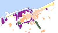
Dunkirk is characterized by three main functional areas: on the west side of our area, as we can see, there is an intensified presence of industrial activities because the port is the economic core of the area, the residential area is developed in the south area where there is a strong presence of historic buildings. Therefore on the east side there is a residential area characterized by a resort because it is not industrialized and still in direct contact with the coast line. All these functions, however, are not well connected to each other so in the future we assume that the predominant land use will be the infrastructure system.
-
 actual land use of the area
 -
add a caption
-
add a caption

Green/blue infrastructure
- What are the major potential elements of a green/blue infrastructure network? Are these likely to change/disappear? Why is that?
- You find my background material on green infrastructure in our reading list
- add 1-2 graphical representations to the image gallery, you can add more if you like
-
add a caption
-
add a caption
Actors and stakeholders
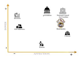
In Dunkerque the primary type of stakeholders is organizations and governmental associations in the area. The district is under the supervision of the municipality of Dunkerque which is one of the main stakeholders with a high level of interest and the influences. Therefore, the French National council for coastline is the highest-ranked interest organization in the area that is caring for landscape and it is responsible of the environmental issues of the area. The council is nominee by the national government every 4 years. Port industries also have a considerable influence as they strongly affect the economy of the area. Local people, tourists, investors, and businessman are considering as the second type of stakeholders. Each of them has a different role in the local society as they influence both social environmental and economic factors of the area. They can lead by the first group of the stakeholders to improve and promote the development factors of the area of Dunkerque.
-
 File:Power map Dunkerque East.JPG

Sacred spaces and heritage
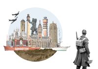
The place that more than any other in Dunkerque holds a strong cultural value is the port, which contributed to the birth and the development of the city itself over the centuries. It started out as a centre of herring fishing under the Counts of Flanders in the 11th century and began to engage in commercial traffic after 1350 as a result of contacts with Holland and England. Its expansion continued until the mid-18th century, alternating with the numerous bombings and reconstructions in the times of wars, which contributed to its modifications.
The skyline of Dunkerque is then spread out horizontally over the sea, that makes it easy to catch the vertical elements that rise over the civil buildings, like towers, bell towers and lighthouses, most of which are protected by UNESCO and represent a strong part of the cultural heritage of the city. Among the most relevant:
- La Tour du Leughenaer (1450)
- Le beffroi de Dunkerque (xv sec, monument historique depuis 1840)
- Le phare de Dunkerque ou phare du Risban (1842)
- L’hôtel de ville de Dunkerque (1897-1901, its belfry was declared a UNESCO World Heritage Site in 2005)
- Feu de Saint-Pol (1937)
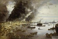
Dunkirk was also the scene of the historic evacuation of the British Expeditionary Force from France in May and June 1940. Known as Operation Dynamo, it was the largest evacuation of Allied forces during the Second World War. That's why the places of the wars that took place in Dunkerque had a great impact in changing the anthropic system of the city and, most of all, its symbolical value, with the introduction of many memorial sites and cemeteries (like the "Dunkirk Memorial", unveiled in Dunkerque on 29 June 1957 by Queen Elizabeth).
But the natural system of the city is rich in cultural heritage as well, thanks to the Dunes of the Flemish maritime plain, which characterize the coastline and are included in the List of Sites of Community interest for Natura 2000.
-
 Dunkerque watercolor plan in 646
 -
 Map of Dunkerque in 1400
 -
 The naval park arsenal at the end of the 18th century
 -
 Artwork of Dunkerque heritage


Visual appearance and landscape narrative
Due to its historical and symbolic value, Dunkerque has been the subject of several movies and visual artpieces:
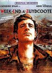
“Week-end à Zuydcoote” (1964) and “Dunkirk” (2017), are just two of the famous movies which take place during Operation Dynamo in Second World War, under the German bombardments;
“Karnaval” (1999), instead, takes place during the traditional Dunkirk Carnival, catching another face of the cultural heritage of this land;
In the music field, the “Cantate à Jean Bart”, popular "anthem" of Dunkerque, is a song played on the evening of the Dunkirk Band directly in front of the statue of the hero, where the crowd of "carnivals" meet and sing on their knees, with arms stretched towards the sky.
Also many painters, like Jean Baptiste Camille Corot, Charles Ernest Cundall, Paul Signac and many other local and contemporary artists, celebrated the beauty of Dunkerque’s landscape in their paintings, focusing on the coastal landscape with the sea and the sand dunes.
-
 Week-end à Zuydcoote (film, 1964)
 -
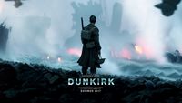 Dunkerque (film, 2017)
 -
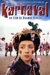 Karnaval (film, 1999)
 -
 “Cantate à Jean Bart”
 -
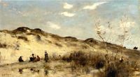 A dune in Dunkerque, Jean Baptiste Camille Corot
 -
 The withdrawal from Dunkirk, Charles Ernest Cundall (1940)
 -
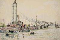 Dunkerque, Paul Signac
 -
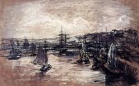 The harbour of Dunkerque, Alexis Vollon


.jpg)

A.2 Summary of your landscape system analysis and your development targets
- You can summarize your findings with an DPSI(R) Model or a Spider Diagram
- Link back to the Sustainable Development Goals: Which goals are at risk?
- What is your hypothesis for this landscape?
- Visualise your hypothesis with one graphic/pict
- Are there any existing initiatives taking action in this landscape? Do you have a critical perspective on that?
- Add text and visuals
-
explain your analysis briefly in the caption
-
explain your hypthesis briefly in the caption
A.3 Theory reflection
- Reflect on at least three international policy documents in relation to their local landscape case
- choose one international, one European and one national document
- You can choose references from our reading list
- Scope: 250 words
A.4 References
- give a full list of the references you have used for this section
Phase B: Landscape Evaluation and Assessment
B.1 Assessment Strategy
- Based on the hypothesis derived from your previous landscape systems analysis you are now asked to define the goals for assessing the landscape. Your assessment is the basis for evaluating the landscape status.
- Which elements and phenomena need to be mapped, why and how?
- This a text contribution, max 250 words
B.2 Mapping
- As defined by your assessment strategy you conduct the mapping and present your findings here
- As a minimum, at least three different themes need to be mapped, you may choose more if needed
-
briefly explain the findings of your mapping
-
briefly explain the findings of your mapping
-
briefly explain the findings of your mapping
B.3 Problem definition and priority setting
- Give a summary of the major findings of your mapping process, what are the problems/potentials identified?
- Draw a problems/potentials map
- Set priorities for the most relevant issues
-
add caption here
B.4 Theory reflection
- Please reflect the assessment and evaluation methods used based on at least three readings
- Did you encounter limitations'
- 200 words test contribution
B.5 References
- give a full list of the references you have used for this section
Phase C – Strategy and Master Plan
C.1 Goal Setting
- Define strategic planning objectives based on the evaluation findings
- Link back to your original targets from section one and the Development Goals
- 150 words text contribution
C.2 Spatial Strategy and Transect
- translate your strategic goals into a vision
- develop a spatial translation of your vision
- exemplify your vision in the form of a transect with concrete interventions
- add map(s) and visualizations
-
add caption here
-
add caption here
-
add caption here
-
add caption here
C.3 From Theory of Change to Implementation
- For implementing your vision: Which partnerships are needed? Which governance model is required?
- Who needs to act and how? Draw and explain a change/process model/timeline
- Which resources are needed? On which assets can you build?
- add 150 words text and visuals
-
add caption here
-
add caption here
C.4 References
- give a full list of the references you have used for this section
D. Process Reflection
- Reflect in your intercultural and interdisciplinary team on the outcomes of your study
- Which limitations were you facing?
- What have you learnt from each other?
- What would you do differently next time?
- You can also use diagrams/visuals
- 250 words text