COLAND Case Study 2020 - Nieuwpoort
>>>back to working groups overview
Rationale
- Why do you think this case is relevant? What is your hypothesis considering the landscape challenges?
- Format: 3-4 sentences
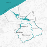
Location and scope
You can edit this map with the map editor
A Landscape System Analysis
A.1 Landscape layers and their system context
Geomorphology, landscape units and coastal typology
- Description of evolution, status quo and driving forces, is the coastal typology changing? Why is that? (approx 200 signs)
- add 1-2 graphical representations to the image gallery, you can add more if you like
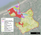
Land use
- settlements, infrastructure, agriculture, resource extraction, natural areas, energy production...
- description of evolution, status quo and driving forces, is the land use likely to change? Why is that? (approx 200 signs)
- add 1-2 graphical representations to the image gallery, you can add more if you like
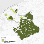
Green/blue infrastructure
- What are the major potential elements of a green/blue infrastructure network? Are these likely to change/disappear? Why is that?
- You find my background material on green infrastructure in our reading list
- add 1-2 graphical representations to the image gallery, you can add more if you like
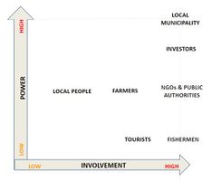
Actors and stakeholders
- Who is driving changes in this landscape? Who is affected by those changes?
- Draw a stakeholder and/or power map: Who is affected highly but with low power? Who has high power but is not affected?
Sacred spaces and heritage
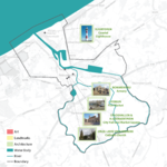
Aside from the existing natural elements in the Nieuwpoort region (the wide beaches, the Yser river and it’s estuary, dunes and grasslands) which are tied to community identity, there are three major built elements in the landscape that are of key importance to local heritage and sacredness.
The first grouping is the architectural elements which are clustered in the old city with one outlier along the coast line. That outlier was the Vuurtoren, the coastal lighthouse, which guided boats into the harbor. Its first iteration was wooden, but was destroyed and rebuilt numerous times by the community. It’s current material is concrete, but it’s function, to keep the community safe, has not changed since the first one was first built in 1284.
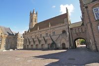
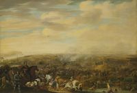
Also keeping watch over the city has been the Onze-Lieve, Our Lady, Catholic Church, which was first constructed in 1163. This gothic church has been destroyed in multiple wars and rebuilt each time. Ironically, it houses a rare painting depicting the Battle of Nieuwpoort, from 1600.
The Bommenvrij, an old armory, the Stadshall and the church, even the lighthouse all signify the resilience of this landscape which has experienced much conflict throughout it’s history. The only architecture which succeeds at resisting a link to that identity is the Vismijn, the traditional fish market.
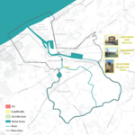
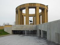
The next grouping of images, the landmarks, all carry on this link to the regions war torn past. The Duvetorre, once the St. Laurents Tower, was destroyed by war but never rebuilt. It keeps its relevance to the community by it’s association with the notorious Jean DePanne, an accused witch, who was know to use the space for devil worship. The Ganzepoot, which for most would appear to be a functional piece of infrastructure for managing water levels, was actually the tool used to stave off the Germans during WW I when a local citizen open the channel to flood the landscape, ultimately halting the advancing German army and saving the town. And the last landmark image, the Westfront, is actually a war memorial to that exact event.
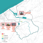
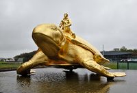
However, the ties to heritage do not always determine community identity or correlate to the spaces that signify sacredness. Public sculpture, especially site specific art installations, are the essence of sacredness as they tie imagery and symbolism into the landscape through deeper concepts. The object tap into the landscape itself, while bringing new meaning with them by introducing new symbols. In Nieuwpoort there are four sculptural installations that root themselves in the landscape. The work by Jan Fabre in the image below ties itself to the horizon with a title that is both forward looking and optimistic. The work Men is placed in the tidal zone, so as to make the work seem almost dynamic, as it plays with the sea level on a daily basis. Oriented towards the town itself, it plays off a completely different energy than the Jan Fabre work.
There are two other works in the city, both are places around the harbor. The first, The Wind Blows Where it Wants is unique in that it is able to visualize a force that actually drives the landscape, the wind that forms the dunes. It gives body to a dynamic, powerful yet nearly invisible force that is a constant for coastal communities, by placing hundreds of flags in a space where the community is very likely to experience it. The last work De Poolreiziger is a work dedicated to a contemporary Belgian polar explorer who was also a citizen of the Nieuwpoort community.
In many ways, these structures evoke the experiences and values this community has at times in its history expressed or even absorbed in its present day.
Searching for Utopia This sculpture, by world famous Belgian artist Jan Fabre, was installed at its site on the shoreline so that the gaze of the figure is looking out to sea at the horizon. Site specific installations of sculpture integrate landscape elements into their concept, embedding them into landscape identity.
Visual appearance and landscape narrative
- Which elements are essential for the landscape character?
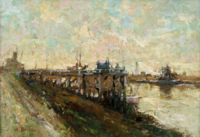
- Has the landscape been painted or otherwise depicted, when and whom? Which elements are essential?
- Which narratives exist? Who has written about this landscape or depicted it in some way?
- You can add text and images
A.2 Summary of your landscape system analysis and your development targets
- You can summarize your findings with an DPSI(R) Model or a Spider Diagram
- Link back to the Sustainable Development Goals: Which goals are at risk?
- What is your hypothesis for this landscape?
- Visualise your hypothesis with one graphic/pict
- Are there any existing initiatives taking action in this landscape? Do you have a critical perspective on that?
- Add text and visuals
- Your case your spider diagram or dpsir model.jpg
explain your analysis briefly in the caption
- Your case your hypothesis visual.jpg
explain your hypthesis briefly in the caption
A.3 Theory reflection
- Belgian Document
Belgian National Adaptation Plan 2017 - 2020
Due to the reason of climate change effect and changing socio-economic condition of the Nieuwpoort costal area, few measures form Belgian National Adaptation Plan 2017 – 2020 need to be count. From out studies we can ensure that the Measure 1 (Development of high resolution climate scenarios for Belgium), Measure 7 (Evaluation of the socio-economic impacts of climate change in Belgium) and Measure 8 (Take climate change impacts and adaptation needs into account in the framework of the future National Environmental Health Action Plan -NEHAP) are directly and also indirectly involved in our study area (Nieuwpoort).
- Reflect on at least three international policy documents in relation to their local landscape case
- choose one international, one European and one national document
- You can choose references from our reading list
- Scope: 250 words
A.4 References
- give a full list of the references you have used for this section
Phase B: Landscape Evaluation and Assessment
B.1 Assessment Strategy
- Based on the hypothesis derived from your previous landscape systems analysis you are now asked to define the goals for assessing the landscape. Your assessment is the basis for evaluating the landscape status.
- Which elements and phenomena need to be mapped, why and how?
- This a text contribution, max 250 words
B.2 Mapping
- As defined by your assessment strategy you conduct the mapping and present your findings here
- As a minimum, at least three different themes need to be mapped, you may choose more if needed
- Your case your assessment mapping themel.jpg
briefly explain the findings of your mapping
- Your case your assessment mapping theme2.jpg
briefly explain the findings of your mapping
- Your case your assessment mapping theme3.jpg
briefly explain the findings of your mapping
B.3 Problem definition and priority setting
- Give a summary of the major findings of your mapping process, what are the problems/potentials identified?
- Draw a problems/potentials map
- Set priorities for the most relevant issues
- Your case problems potentials map.jpg
add caption here
B.4 Theory reflection
- Please reflect the assessment and evaluation methods used based on at least three readings
- Did you encounter limitations'
- 200 words test contribution
B.5 References
- give a full list of the references you have used for this section
Phase C – Strategy and Master Plan
C.1 Goal Setting
- Define strategic planning objectives based on the evaluation findings
- Link back to your original targets from section one and the Development Goals
- 150 words text contribution
C.2 Spatial Strategy and Transect
- translate your strategic goals into a vision
- develop a spatial translation of your vision
- exemplify your vision in the form of a transect with concrete interventions
- add map(s) and visualizations
- Your case spatial translaton vision.jpg
add caption here
- Your case transect.jpg
add caption here
- Your case transect detail1.jpg
add caption here
- Your case transect detail2.jpg
add caption here
C.3 From Theory of Change to Implementation
- For implementing your vision: Which partnerships are needed? Which governance model is required?
- Who needs to act and how? Draw and explain a change/process model/timeline
- Which resources are needed? On which assets can you build?
- add 150 words text and visuals
- Your case spatial your governance model.jpg
add caption here
- Your case spatial your process model.jpg
add caption here
C.4 References
- give a full list of the references you have used for this section
D. Process Reflection
- Reflect in your intercultural and interdisciplinary team on the outcomes of your study
- Which limitations were you facing?
- What have you learnt from each other?
- What would you do differently next time?
- You can also use diagrams/visuals
- 250 words text

