COLAND Case Study 2020 - Al Mina, Lebanon
>>>back to working groups overview
| Area | Al Mina | |
| Place | Tripolis | |
| Country | Lebanon | |
| Topics | please enter the main coast-related topics here | |
| Author(s) | Please enter your name(s)- optional | |

| ||
Rationale
- 'The coast of Al Mina is mostly sandy. This coast is also interactive, causing the people to have a strong relationship with the water. Moreover, the coast is accessible, where many fishermen come to this coast, and people access it to spend time. Our aim is to bring back this strong relationship between the people and the coast, and increase accessibility. in addition, taking care of the erosion at the coast by rehabilitating the area.
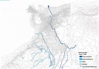
Location and scope
You can edit this map with the map editor
A Landscape System Analysis
A.1 Landscape layers and their system context
Geomorphology, landscape units and coastal typology
- Description of evolution, status quo and driving forces, is the coastal typology changing? Why is that? (approx 200 signs)
- add 1-2 graphical representations to the image gallery, you can add more if you like
-
add a caption
-
add a caption
Land use
Green/blue infrastructure
- What are the major potential elements of a green/blue infrastructure network? Are these likely to change/disappear? Why is that?
- You find my background material on green infrastructure in our reading list
- add 1-2 graphical representations to the image gallery, you can add more if you like
-
 add a caption

File:greenspace_mina_Lebanon.JPG|add a caption </gallery>
Actors and stakeholders
-
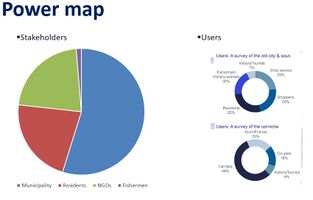 add a caption

Sacred spaces and heritage
- Which places/elements hold cultural value and to whom?
- You may add a map and some images, please also explain in your caption why these elements are valuable
-

-
add a caption
-
add a caption
-
add a caption

Visual appearance and landscape narrative
- Which elements are essential for the landscape character?
- Has the landscape been painted or otherwise depicted, when and whom? Which elements are essential?
- Which narratives exist? Who has written about this landscape or depicted it in some way?
- You can add text and images
-
add a caption
-
add a caption
-
add a caption
A.2 Summary of your landscape system analysis and your development targets
- You can summarize your findings with an DPSI(R) Model or a Spider Diagram
- Link back to the Sustainable Development Goals: Which goals are at risk?
- What is your hypothesis for this landscape?
- Visualise your hypothesis with one graphic/pict
- Are there any existing initiatives taking action in this landscape? Do you have a critical perspective on that?
- Add text and visuals
-
explain your analysis briefly in the caption
-
explain your hypthesis briefly in the caption
A.3 Theory reflection
- Reflect on at least three international policy documents in relation to their local landscape case
- choose one international, one European and one national document
- You can choose references from our reading list
- Scope: 250 words
A.4 References
- give a full list of the references you have used for this section
Phase B: Landscape Evaluation and Assessment
B.1 Assessment Strategy
- Based on the hypothesis derived from your previous landscape systems analysis you are now asked to define the goals for assessing the landscape. Your assessment is the basis for evaluating the landscape status.
- Which elements and phenomena need to be mapped, why and how?
- This a text contribution, max 250 words
B.2 Mapping
- As defined by your assessment strategy you conduct the mapping and present your findings here
- As a minimum, at least three different themes need to be mapped, you may choose more if needed
-
 briefly explain the findings of your mapping
 -
 briefly explain the findings of your mapping
 -
briefly explain the findings of your mapping


B.3 Problem definition and priority setting
- Give a summary of the major findings of your mapping process, what are the problems/potentials identified?
- Draw a problems/potentials map
- Set priorities for the most relevant issues
-
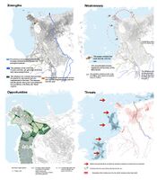 add caption here

B.4 Theory reflection
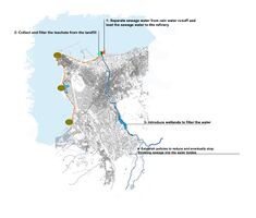
- Develop environmentally-resilient solutions that take into consideration the natural and man-made erosive factors, the sewage outlets, and the sensitive habitats of the coastal landscape
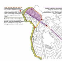
Enhance pedestrian accessibility and transportation along the promenade and the coastal road
Strengthen the city’s relationship to the seafront through re-envisioning the promenade and allowing public and inclusive accessibility to the coast
Utilize resources available in the coastal landscape for sustainable, economic development
CRITICAL REFLECTION Limitations include:
Environmental degradation of the coastline
Poor condition of the current promenade
Socio-economic status of the population (majority: low-income)
Overpopulation of the city
B.5 References
- give a full list of the references you have used for this section
Phase C – Strategy and Master Plan
C.1 Goal Setting
- From an Urban Morphology Perspective: (SDG: Clean Water, Clean Energy, Industry and Infrastructure, Sustainability )
Introduce green and blue infrastructure "
- From a Mobility Perspective: (SDG: Sustainability)
Provide good transportation system Develop coastal road and pedestrian movement "
- From an Infrastructure and Economy Perspective: (SDG: Economic Growth, Industry and Infrastructure, Life Under Water)
Provide good roads Increase the economy through exporting from the port Provide work opportunities "
- From an Environmental Perspective: (SDG: Clean Water, Good Health, Clean Energy, Responsible Consumption, Climate Action, Life Under Water, Life on land )
Provide clean water to the citizens Divide sewage water from the rain water runoff Collect and filter the leachate from the landfill ‘ Generate energy from waste
C.2 Spatial Strategy and Transect
- translate your strategic goals into a vision
- develop a spatial translation of your vision
- exemplify your vision in the form of a transect with concrete interventions
- add map(s) and visualizations
-
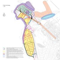 add caption here
 -
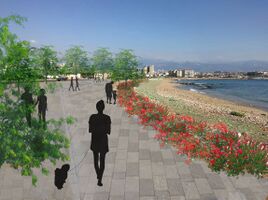
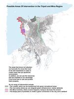 possible areas of interventions in Al-Mina, Tripoli
 -
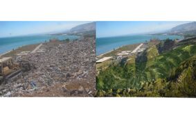 intervention 1:landifill
 -
 intervention 2: coastline


C.3 From Theory of Change to Implementation
- Partnerships Needed: Mina Municipality, Tripoli Municipality, USAID, Ministry of Health, Ministry of Environment, Nurseries, Environmentalists, Water Specialists."
- Involvement: For a better project design and implementation, the local community needs to be involved in the working process through workshops, trainings and awareness campaigns."
- Resources: Research and studies on the previous and existing conditions of Mina to provide a clear futuristic plan of Mina. Research and studies to create an overall city strategy for a more sustainable and developed Mina.
-
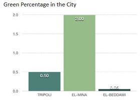 percentage of green spaces in Tripoli, Al-Mina and El-Beddawi
 -
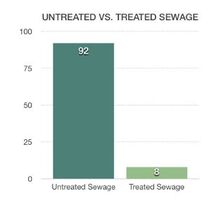 untreated sewage vs. treated sewage in Tripoli and Al-Mina


C.4 References
- give a full list of the references you have used for this section
D. Process Reflection
- Mina has proven to be a challenge due to many stakeholders involved: projects need to be responding to everyone’s needs.
Mina Municipality wasn’t cooperative as much as we hoped, they are financially unable to implement any project. 40% of Mina families are under the line of poverty which leads them to be uninterested in implementing projects that don’t generate profit. For a better outcome, the interaction with Mina residents and locals should be enhanced in order to understand their needs and use it for better projects ideas.