Orkney Islands
>>>back to working groups overview
| Area | Bay of Skaill | |
| Place | Orkney Mainland | |
| Country | Scotland, UK | |
| Topics | Orkney World Heritage Sites and coastal erosion | |
| Author(s) | Anna Ilyuchshenko | |

| ||
Rationale
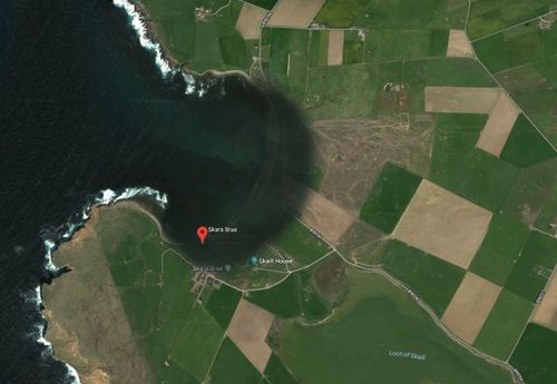
Skara Brae is the most well-preserved European settlement of the Neolithic Age, discovered at the Bay of Skaill on the west coast of Mainland, Orkney Islands, Scotland. The monument is included in the UNESCO World Heritage List and has a great value for human history reconstruction. This large settlement consists of 8 stone-built clustered houses, which were inhabited in the period of approximately 3100-2500 BC, which makes it even older than Stonehenge and the Great Pyramids. Proximity of the coastline is a threat to this monument, likely some of the ancient structures were already swallowed up by the sea.
Location and scope
You can edit this map with the map editor
A Landscape System Analysis
A.1 Landscape layers and their system context
Geomorphology, landscape units and coastal typology
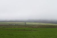
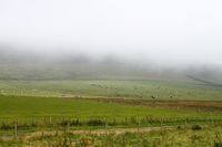
Except the sandy dunes of the Bay of Skaill, the coast consists of cavernous cliffs of Stromness flagstones, Middle Old Red Sandstones of Orkney. The Orkney landscape is mostly open, low lying with smooth relief. The lack of diversity occurs in landscape types of features. The typology includes two main features - a large flat arable land and a hilly ground.
-
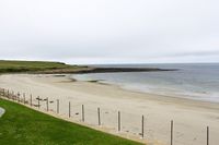 the Bay of Skaill shoreline
 -
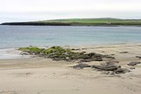 the Bay of Skaill shoreline


Land use
The biggest part of Orkney land use consists of planned rectilinear fields and farms. Near 60 per cent of the total area is farmland with grassland and arable crops. The rest of the area is mostly moorland, but also includes development areas, coastal areas and lowland nature reserves. The agricultural economy is based on rearing livestock, dairy cattle, production of beef, lamb and wool. The most distinctive feature of the agricultural landscape is its improved pasture. Agriculture was always the most prevalent way in which humans have managed the landscape of Orkney. There is no significant forces capable to change the situation.
-
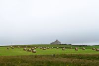 Farmland
 -
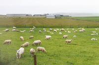 Pasture
 -
 Farmland
 -
 Grassland


Green/blue infrastructure
The major potential elements of a green and blue infrastructure network of the area are continuous monotonous fields and pastures, a lake and the sea itself. Nowadays, there is no significant prerequisites for drastic changes of green and blue infrastructure network.
-
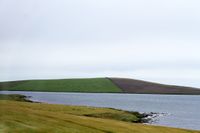 Blue infrastructure
 -
 Green infrastructure


Actors and stakeholders
Mostly, this area meets an undeniable threat from climate change. The driving changes in this landscape are quickly rising sea level, coastal erosion and severe weather conditions. The affected zones by the climate change are precious historical sites, such as Skara Brae and several others. The map below shows main actors and stakeholders, who could affect the situation.
-
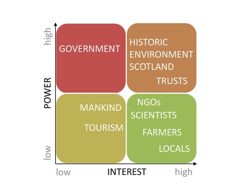 Power map

Sacred spaces and heritage
The most valuable site in this area is the famous, one of the best preserved Stone Age villages in the world - Skara Brae. It has not only a great value to the local economy, but also an outstanding universal significance.
-
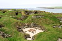 Skara Brae, historical site
 -
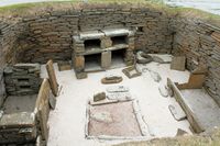 Skara Brae
 -
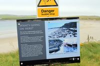 Threat
 -
 MapRoyal Commission on the Ancient and Historical Monuments of Scotland


Visual appearance and landscape narrative
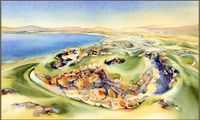
According to the Land Use Consultants in Scottish Natural Heritage Review No 100, "the monotonous continuity of fields and the tapestry of greens and yellows is a dominant image of the landscape. Low sunlight often exaggerates the colors and textures of these fields. Spring grass growth in particular can appear as a vivid green blanket". The Orkney landscape was painted and described countless of times by Scottish painters and writers and others. However, our interest is on the historical site Skara Brae. The village was uncovered by a storm in 1850, therefore there is more modern art which shows the landscape of the site. Some paintings are represented below. Besides painting, Skara Brae was mentioned in several books, such as "The Boy with the Bronze Axe" by Kathleen Fidler, "Shifting Sands" by Rosemary Sutcliff, "A History of the Twentieth Century" by Kim Stanley Robinson. A reference to Skara Brae was even made in the film "Indiana Jones and the Kingdom of the Crystal Skull". Jones is shown lecturing to his students about this historical site.
-
 SKARA BRAE, Gregg Allan McGivern
 -
 SKARA BRAE ORKNEY, Jonathan Wheeler
 -
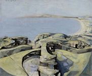 SKARA BRAE, Michael Ayrton
 -
![SKARA BRAE [Abstract N° 1847], Koen Lybaert](/images/thumb/c/cf/Koen_Lybaert.JPG/124px-Koen_Lybaert.JPG) SKARA BRAE [Abstract N° 1847], Koen Lybaert
SKARA BRAE [Abstract N° 1847], Koen Lybaert


![SKARA BRAE [Abstract N° 1847], Koen Lybaert](/index.php?title=File:Koen_Lybaert.JPG)
A.2 Summary of you landscape system analysis and your development Targets
Concerning the sustainable development goals risks, the goal No 4 QUALITY EDUCATION could be at the risk. The beautiful piece of human history can be destroyed for future generations, which makes its study more difficult. The goal No 8 DECENT WORK AND ECONOMIC GROWTH would be affected and be under bigger pressure. This heritage site brings additional resources due to the growing touristic industry.
"Historic Environment Scotland has recognised the problem as recently reported by BBC News. In the light of the issue, the University of the Highlands and Islands Archaeology Institute in partnership with staff from the University of Bradford, The City University of New York, The William Paterson University of New Jersey, Orkney Islands Council and REW Development Trust have created the Swandro-Orkney Coastal Archaeology Trust. The trust is aimed at providing resources for the continued work at Swandro-a priority archaeological site that is in imminent danger of destruction from coastal erosion." The Archaeology Institute, University of the Highlands and Islands.
"Orkney Islands Council prepared the Local Development Plan that sets out the Council’s policy for assessing planning applications and proposals for the allocation of land for development. The Plan contains policies that address the need to put an appropriate level of protection in place for the property and its setting. Supplementary Planning Guidance for the World Heritage Site has also been produced."UNESCO
Due to the climate change and coastal erosion issues, this precious heritage site may be washed away, the zone may be covered by water.
-
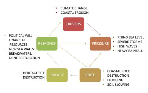 The figure shows the main drivers, possible pressure and state of the environment, future consequences and potential steps for problem solving.

-
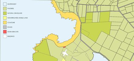
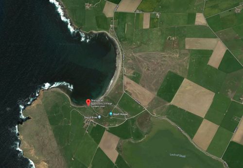 Current situation. The map is based on Google Maps.
 -
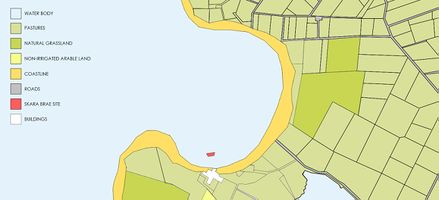
 Hypothesis for this landscape. Due to the climate change and coastal erosion issues, this precious heritage site may be washed away, the zone may be covered by water.The map is based on Google Maps.


A.3 Theory reflection
The Orkney Local Development Plan 2017
The Orkney Local Development Plan 2017 is currently the main document with the associated Supplementary Guidance used for decision-making. This document was prepared by Orkney Islands Council. The Orkney Local Development Plan 2017 displays a spatial strategy for the development of Orkney Islands for the next 10-20 years, and responds to the following policies such as Scotland’s Third National Planning Framework, Scottish Planning Policy (SPP) and Planning Series Circular 6/2013: Development Planning. The Plan is renewed every 5 years; the actual period of the current document is 2017 to 2022. The document examines changes of the environment, economy and society of Orkney Islands, national planning documents, and relevant public consultations. Scottish Natural Heritage, Historic Environment Scotland, Scottish Water, and the Scottish Environment Protection Agency and other main agencies were involved in formation of the document. The Plan consists of the land use planning policies and development proposals for settlements.
The Policies that are included into the Development Plan are:
Policy 1: Criteria for All Development
Policy 2: Design
Policy 3: Settlements, Town Centres and Primary Retail Frontages
Policy 4: Business, Industry and Employment
Policy 5: Housing
Policy 6: Advertisements and Signs
Policy 7: Energy
Policy 8: Historic Environment and Cultural Heritage
Policy 9: Natural Heritage and Landscape
Policy 10: Green Infrastructure
Policy 11: Outdoor Sports, Recreation and Community Facilities
Policy 12: Coastal Development
Policy 13: Flood Risk, SuDS and Waste Water Drainage
Policy 14: Transport, Travel and Road Network Infrastructure
Policy 15: Digital Connectivity
“These policies establish a general commitment to preserving the integrity and authenticity of the property. They also seek to manage the impact of development on the wider landscape setting, and to prevent development that would have an adverse impact on its Outstanding Universal Value through the designation of Inner Sensitive Zones, aligned with the two parts of the buffer zone and the identification of sensitive ridgelines outside this area. The Rural Conservation Area at Brodgar includes Maeshowe, the Stones of Stenness and the Ring of Brodgar, and it is envisaged to establish a Rural Conservation Area at the Bay of Skaill.” UNESCO
A.4 References
http://earthwise.bgs.ac.uk/index.php/Middle_Old_Red_Sandstone_of_Orkney,_Stromness_Flags
https://e360.yale.edu/features/heritage-at-risk-how-rising-seas-threaten-ancient-coastal-ruins
https://archaeologyorkney.com/2017/01/10/coastal-erosion-and-heritage-in-orkney-new-trust-launched/
https://whc.unesco.org/en/list/514
Land Use Consultants 1998. Orkney landscape character assessment. Scottish Natural Heritage Review No 100. (http://www.snh.org.uk/publications/on-line/LCA/orkney.pdf)
http://www.orkney.gov.uk/Service-Directory/H/strategy-and-policy.htm
Phase B: Landscape Evaluation and Assessment
B.1 Assessment Strategy
The main goals for the assessment, which were determined for this case study, are:
- to provide information about the zone and possible risks for the site
- to identify sensitive aspects of the site
- to develop plans and strategies in order to protect the site
As was mentioned in the previous part, the main risk for the Skara Brae site is the climate change. Due to the sea level rise and coastal erosion issues, this historical heritage site may be lost for future generations. The choice of the goals listed above was based on the existing issue. First of all, we need to collect the available data regarding this specific coastal landscape and its potential sensitivity for climate change, then to detect the most vulnerable aspects and try to derive the strategy for preventing the site destruction.
As a part of the assessment, the elements, that need to be mapped, are the current land use and the land use after the climate change influence, the most prominent ecosystem services of the coastal area, and mapping of the possible threats for the landscape.
B.2 Mapping
-
 Current land use
 -
 Land use after the climate change influence. Due to the climate change, the coastline may deepen to the land, destroying Skara Brae and flooding parts of the pastures and agricultural fields.
 -
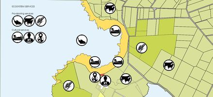 Ecosystem services.The most prominent ecosystem services of the coastal area are provisioning (food, wool) and cultural (aesthetic, spiritual, educational, recreational) ecosystem services.
 -
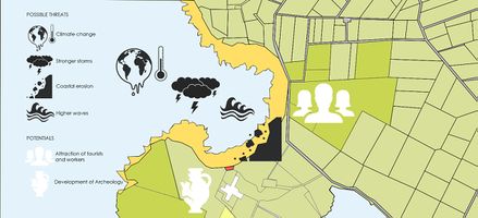 Possible threats and potentials of the zone. As main threats for this site, climate change with its effects and coastal erosion are shown. Regarding the potentials, attraction of tourists and workers and development of archaeology are listed.


B.3 Problem definition and priority setting
Regarding the major findings of the mapping process, I identified climate change and coastal erosion as the most significant threats for this coastal landscape, in particular, for the historical site Skara Brae. Though the zone is very underpopulated and land use is monotonous, the landscape has an immense importance for humanity due to the site mentioned previously.
-
 Assessment synthesis and Priorities and targets

B.4 Theory reflection
As one of the assessment and evaluation methods, I applied the Ecosystem Services Approach, which lists ecosystem goods and their functions. For the last two decades several authors have attempted to define the term ecosystem functions. Here we follow the definition given by Rudolf S. de Groot et al. which describes the ecosystem functions as "the capacity of natural processes and components to provide goods and services that satisfy human needs, directly or indirectly" [De Groot, R.S., et al.: Functions of nature: evaluation of nature in environmental planning, management and decision making. Wolters-Noordhoff BV (1992)].
The term ecosystem services is generally understood as benefits provided by nature. According to Daily, ecosystem services are "the conditions and processes through which natural ecosystems, and the species that make them up, sustain and fulfill human life" [Daily, G.: Nature’s services: societal dependence on natural ecosystems. Island Press (1997)]. Despite the existence of this topic for several decades, the ecosystem services have received much attention only in last 17 years due to the Millennium Ecosystem Assessment which distinguished four categories: supporting services that are used to sustain other services, namely provisioning, regulating, and cultural services. Important part here is that all of them directly affect people [Assessment, M.E.: Assessment: Ecosystems and human well-being: A framework for assessment (2003)].
Limitations encountered during the assessment phase:
Amount of available time
Theoretical Information Overload
Lack of practical examples
B.5 References
http://oic.maps.arcgis.com/apps/MapJournal/index.html?appid=da0730babf6249bb8c67b749004b42fa
Orkney Local Development Plan
Vulnerability of Cultural Heritage to Climate Change Report https://www.coe.int/t/dg4/majorhazards/activites/2009/ravello15-16may09/ravello_apcat2008_44_sabbioni-jan09_en.pdf
A Framework for Assessing the Vulnerability of Archaeological Sites to Climate Change: Theory, Development, and Application
Burkhard B, Maes J (Eds.) (2017) Mapping Ecosystem Services. Pensoft Publishers, Sofia, 374 pp.
Phase C – Strategy and Master Plan
C.1 Goal Setting
- Define strategic planning objectives based on the evaluation findings
- Link back to your original targets from section one and the Development Goals
- 150 words text contribution
C.2 Spatial Strategy and Transect
- translate your strategic goals into a vision
- develop a spatial translation of your vision
- exemplify your vision in the form of a transect with concrete interventions
- add map(s) and visualizations
-
add caption here
-
add caption here
-
add caption here
-
add caption here
C.3 From Theory of Change to Implementation
- For implementing your vision: Which partnerships are needed? Which governance model is required?
- Who needs to act and how? Draw and explain a change/process model/timeline
- Which resources are needed? On which assets can you build?
- add 150 words text and visuals
-
add caption here
-
add caption here
C.4 References
- give a full list of the references you have used for this section
D. Process Reflection
- Reflect in your intercultural and interdisciplinary team on the outcomes of your study
- Which limitations were you facing?
- What have you learnt from each other?
- What would you do differently next time?
- You can also use diagrams/visuals
- 250 words text