South of Pärnu
>>>back to working groups overview
| Area | South from Pärnu to the town of Häädemeeste | |
| Place | Pärnumaa, Pärnu lahe hoiuala | |
| Country | Estonia | |
| Topics | Baltic sea, Rail Baltic, recreation area, border area | |
| Author(s) | Marie, Kristel, Eelar, Liisi | |

| ||
Rationale
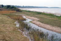
Estonian coast of the Baltic sea, south from Pärnu to the borders with Latvia, is an area shaped by many different factors and offering many possibilities, issues and topics. Water plays and important role here, not only in the form of sea but also bogs or floods. Other main topics may be Rail Baltic and the major influence of tourism and its seasonality.
Location and scope
You can edit this map with the map editor
A Landscape System Analysis
A.1 Landscape layers and their system context
Geomorphology, landscape units and coastal typology
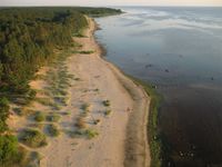
The coastal region of Pärnu and its neighborhood has formed after the meltdown of the continental ice sheet. The landforms of the coastal land have emerged from that process creating new landscapes. After the Ice done its job the coastal landscape was exposed to the erosion by the wind and the water and add to that the land rise less than 1mm a year it will complete the picture of how the coastal land has come into being. The coastal area beaches are covered mostly by sand changing in the north from fine grain to the gravel in the south. Since the melting of ice front has huge quantities of clay deposited in the lower parts of the area, the sand covering the soil is sensible to the erosion caused by the rise waters at some spots. Therefore creating the breaks on the coastal surface in those locations. The other characteristic feature is the dunes of sand reaching the height of 15m in the north and down to the 35m in the south above the sea level. Sand is most common in coastal areas wherein river deltas it starts to block the streams. In Pärnu, the sand is creating the additional deposits increasing the beach area. Partly because of the sand deposition the first known wave breaker made from wood have been built in Pärnu which after 100 years were replaced with a stone structure.
-
 kabli beach a photo by Heidi tooming
 -
 geomorphology


Land use
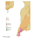
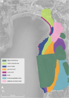
Most of the area especially in the south is covered by forest or agro-forestry land. Agricultural land is spread out around Uulu and in a stripe parallel with the coast in the south. An Important part of this area is peat bogs and inland marshes located between Võiste and Häädemeeste and north of Pärnu. The direct coast is mostly intertidal flats, grasslands or forests. There is no important resources extraction or energetics activity going on. But the national plan gives space for potential wind farm construction on the sea, south from Kihnu island. The population of this area is decreasing and with it the active (agricultural and industrial) use and maintenance of the land. The major potential factors that could change the land use is spreading tourism from Pärnu to other parts of the coast, increasing work opportunities, the construction of Rail Baltic. Settlements: Settlements in the area are: Pärnu, Reiu, Uulu, Laadi, Tahkuranna, Võiste, Leina, Soometsa, Piirumi, Rannametsa, Papisilla, Häädemeeste, Arumetsa, Jaagupi, Kabli, Majaka, Orajõe, Treimani, Metsapoole, Ikla The most important settlements are Pärnu (third biggest city in Estonia, Summer capital and a popular tourist/recreation area), Uulu (crossroad of main important communications, growing industry and possible job opportunities) and Häädemeeste (bigger settlement, located in the centre of the studied area with near proximity to the bog lands) Road E67 runs parallel to the coast from Latvia to Pärnu. The west side of this road is generally more inhabited and used for agriculture, the east side is more forest and natural areas (LKA, hoiuala) Infrastructure: Road 331 directly on the coast, road E67 approximately 2-3 km from the coast. Both parallel. The Connection of road 6 from central Estonia in the northern part (Uulu). No Rail so far but planned Rail Baltic (both potential positive factor and a source of distraction and interruption of the area). Natural areas: Pärnu MKA, Vaskjõe LKA, Valgeraba hoiuala, Uulu-Võiste hoiuala, Siiraku LKA, Luitemaa LKA, Luitemaa hoiuala, Tolkuse LKA, Neptemurru hoiuala, Nigula LKA, Laulaste LKA, Kiusumetsa hoiuala, Massiaru hoiuala Natura2000 areas: Quite a big part of the area is rated as Habitats Directive Sites (pSCI, SCI or SAC) or Birds Directive Sites (SPA) or both by Natura2000. These parts are mostly around boglands in the northern part of the analysed area and forests in the southeast of the area. Also a big part of the Pärnu Gulf - The Pärnu Bay Conservation Area - is rated as Birds Directive Sites (SPA)
-
 Map of land use of the case study area.
 -
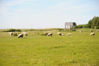 Sheep at the Kabli coastal meadow
 -
 Lemme beach


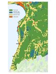
Green/blue infrastructure
Mainly there are two major green/blue structure elements, first the river of pärnu and the greenbelt around it not to mention the numerous streams coming into the bay. The second dominant element is the forest covering the land. Concerning different variables the Rail Baltic may be considered the biggest impact to those, otherwise, influence with that significance couldn’t drive the changes to that extent where it’s affecting the coastal area. As long as there are people around taking care of the neighborhood, things will be fine because individuals who could transform the area eventually have to live at that place.
-
 Map of Green/Blue infrastructure
 -
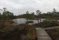 Luitemaa LKA bog
 -
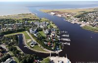 Delta of Pärnu river


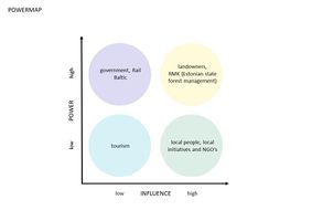
Actors and stakeholders
The changes are driven mostly by the local people whose actions, whether concerning to the taking care of the pasturelands or managing the forest or developing the tourism in the area, are relevant. Additionally, there aren’t any major stakeholders who could by owning the vast pieces of land significantly alter it. Lots of locals do have activities associated with tourism which tend to be seasonal. It affects everyone starting from locals down to the tourist as well. Usually, people from outside could have a high power position and at the same time not being affected. It includes the companies on both private and the state level whose interests lie with the current site but when it comes to money there’s inevitably a risk of withdrawal of resources(benefits). For example, the Rail Baltic has only one stop planned in the city of Pärnu and rest of the area where it passes by doesn’t have any benefits whatsoever for locals.
-
 add a caption

Sacred spaces and heritage
Along the coastal area, there are several national heritage objects situated mostly between the shoreline and road E67 (Via Baltica). Majority of national heritage objects are churches and cemeteries, but we can find also the memorial pillar of Konstantin Päts, one of the founders of Estonian Republic and former captains house in Kabli. In the coastal zone, there are lots of unofficial (not under protection) heritage objects mapped by State Forest Management Centre. These heritage objects like old buildings, old harbours, trees, place names, etc., are part of our national identity, the traces of life and activities of ancestors on the landscape. Pärnu county plan has marked the whole coastal zone from the Pärnu city to the Estonian-Latvian border as a valuable landscape, what is the bearer of the region's cultural-historical identity – traditional land use and settlement, sand beaches, beautiful road views and picturesque places. They hold cultural value at first for the locals as they are characteristic of the area.
-
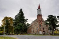 National heritage object - Häädemeeste St. Michaels Church (1874)
 -
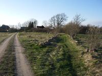 Heritage object - an old village street lined with stonewalls in Rannametsa village
 -
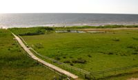 Valuable landscape - Kabli nature reserve


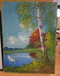
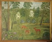
Visual appearance and landscape narrative
Essential landscape characters of the case study area are sandy beaches, pine woods, old settlement structure and open views along the coast. There are several hobby artists who have painted views of case study area in the Häädemeeste municipality. Dora-Alviine Kesper has painted many sailboats built in Kabli, also her ancestor`s captain house (under national protection) in Kabli. She has also written about the life in Kabli. The surrounding of their home has also been depicted by Johannes Müller and Valter Soomre in their paintings. Mati Kose, a local ornithologist and nature protector, has photographed coast and the nature of the case study area. There are many novels, novellas, and poems that describe the places in our case study area. Imre Kaas`s novel “Minu esimesed liblikad” (My First Butterflies) is based on real life and talks about writers childhood in Kabli, the late 1990s. In Elss Järvi kids book “Lapsepõlvelood” (Childhood stories) has mentioned Kabli and Orajõe. Poems are mostly inspired by the sea, written by for example Tiit Merenäkk who`s summer cottage was in Kabli, Manivald Kesamaa “Töökas mees on kõigist ees” (A Hard-working Man is in Front of Everyone), Uno Laht “Tahkuranna idüll” (Idyll of Tahkuranna).
-
 Johannes`s son Konstantin Müller (12.05.1907-3.09.1984)
 -
 Johannes`s son Konstantin Müller (12.05.1907-3.09.1984)
 -
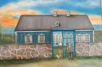 Dora-Alviine Kesper (born 1935) - House of Reeders farm in Kabli


A.2 Summary of you landscape system analysis and your development Targets
The area is geographically and economically separated. It should be connected more in itself as well as with its surrounding. This can be managed by using the potential of natural areas and coast to increase the tourism, restoring the traditional ways of maintaining the landscape (grassland management) and developing job opportunities. This should be implemented with the consideration of local culture and traditions so that they are preserved and become the representative symbol of the area. The amount of initiative of local people proves the need for action and change in the area. If this change doesn't occur, the area will remain more isolated than ever, forest will spread over and natural grassland specific for this area will disappear. People will move away and local traditions or sacred spots will be forgotten. In former Häädemeeste parish had 60 non-profit organisations listed in the year 2016, about a third of them were apartment associations. Most of these organisations were of of local importance nevertheless showing care and interest in the environment and local communities (e.g. cultural and sports activities, village communities, non-profit boat harbour, Häädemeeste beach area development, coastal meadows maintenance organisation) When considering the Sustainable Developement Goals we could say that these might be slightly at risk or at least a little bit forgotten:
1. No poverty - area with less opportunities and choices, longer distances and worse supplying
4. Quality education - with decreased population both need and supply of quality education are low
8. Decent work and economic growth (very much at risk) - the area is losing job opportunities, and workforces are moving away
9. Industry innovation and infrastructure - with decreasing population no new construction or development is happening
-
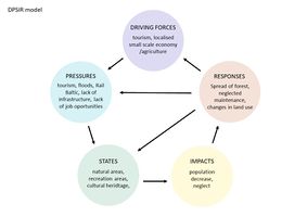 DPSIR model

-
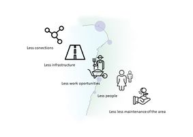 Hypothesis visualization - what would happen if the area was left to its own causes

A.3 Theory reflection
Getting acquainted with Sustainable Development Goals and relating them in Pärnu bay area, there are four most important goals to follow: Goal 1. No Poverty Goal 4. Quality education Goal 8. Decent work and economic growth Goal 9. Industry, innovation, and infrastructure Pärnu bay area situates in the south-west of Estonia and is by its characteristics periphery. In Pärnu bay area listed, goals are in most danger as there might not be enough population for creating new jobs or to ensure quality education. Also decreasing population doesn`t help the economy to grow. In this turn, industry can`t develop and infrastructure is lacking.
The landscape in Pärnu bay area is very diverse- there are coastal meadows, agricultural land, sand dunes, bogs, forest, local roads, transit road Via Baltic and some smaller and bigger settlements. Most of the area is also protected. According to The European Landscape Convention (Florence, 2000), it is important to consider landscape as an essential component of people`s surrounding, as it gives locals their identity. In our area we see, that the existing landscape is worth preserving and developing according to locals needs.
Parliament of Estonia has approved „Estonian Environmental Strategy until 2030“. It points out current trends that has happened or might happen also in South of Pärnu case study area. One of the trends is that due to changes in social and economic conditions, unproductive agricultural land (e.g. low soil fertility of coastal areas) has dropped out of production. Trend of constructing new (rail)roads and communication networks will increase the natural landscapes fragmentation, which leads to the prevention of the migration of animals. It is risk when Rail Baltic is being built. The vision of the strategy is that natural landscapes and traditional cultivated landscapes have survived, in agriculture organic farming and farm tourism predominate. Land use goal is that multi-purpose and coherent landscapes are preserved and that is important in our case study area.
A.4 References
- Statistical maps: https://estat.stat.ee/StatistikaKaart/VKR
- The European Landscape Convention: https://www.coe.int/en/web/landscape/the-european-landscape-convention
- Maa-amet maps of cultural monuments and cultural heritage: http://xgis.maaamet.ee/xGIS/XGis
- Corine Land Cover map: http://www.arcgis.com/home/webmap/viewer.html?webmap=6866b2f3a44c4ee3bde8edd1b0782fb2
- Pärnu county plan: https://www.maavalitsus.ee/142
- Häädemeeste comprehensive plan: http://haademeestevald.kovtp.ee/uldplaneering
- Estonian Environmental Strategy until 2030: https://www.riigiteataja.ee/aktilisa/0000/1279/3848/12793882.pdf#
- Maa-amet geological maps: http://xgis.maaamet.ee/xGIS/XGis?app_id=SMA01&user_id=at&bbox=505528.198653199,6434501.26262626,553785.774410775,6467001.26262626&setlegend=HMAGAPR_01=1&LANG=1
- Arold.I, (2005) Eesti maastikud
Phase B: Landscape Evaluation and Assessment
B.1 Assessment Strategy
According to the analyses three major topics are brought up for to the assessment where it includes the water, nature protection with LCA analysis and population in relation to demographic changes. Clearly, we can’t overlook the importance of the water and its influence on the coastal features and on people’s lives, it has. Secondarily, the amount of the protected area sets some limits to the use of land at the same time leaving some optional activities for locals to decide. Typically, those options involve the grazing and traditional cultivation of the land. To boost up the local agricultural traditions, this would require an additional attention. Some activities might have supported by the EU foundations targeted for the preservation of such traditions. The adverse situation where the coast gets flooded over some period of time has left its marks on the coastal appearance also having some influence over the planning process. In earlier days whenever there was a house built this option always considered. Every rule goes with exceptions and so this one when new developments have constructed next to the waterfront. The consequences won’t be long away resulting in the situation where the owner has to face the succumb of its property to the sea. This is an issue of consideration for the local municipality to prevent such of in the future. Nature protection zones such as reserves and conservation areas cover not just the coast but also the entire bay. Those restrictions may have some influence on the local life but hopefully not too concluded. This assessment aims to map the different levels of pressure on the land and point out problems caused by these pressures and individual factors. Also, to gain a deeper understanding of problems and their causes according to the previous hypothesis considering:
- Demography related issues
- Landscape character and levels of nature protection
- Effects of water (sea as well as inland)
The studied area was narrowed down due to size, a variety of feature and character of the area and its possibilities.
B.2 Mapping
Three maps show our analysis of three deferent layers or approaches to the landscape and overall environment.
-
 landscape character assessment related to protection areas
 -
 effects of water (see and inland) on the area
 -
 demographic changes and human related issues in the area


Map 1: The landscape character assessment has been coupled with mapping of nature protection in the area. What levels and scales of nature protection there area and relation of these areas to the landscape character. This was needed due to many deferent protection and restriction policies affecting the case study area.
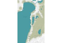
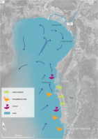
Map 2: Water has an important role here not only in the form of sea and its effects on the direct coast but local rivers bogs, irrigation channels, lake sand so on. The second map shows the sea currents and their affect on the coat in terms of flooding and erosion. Further on it shows deferent types of the costal landscape and accessibility of the coats. Also shown are the few main harbours which reflect the small scale of local population and fishing.
Map 3: In the study area, there are 4 densely populated areas, starting from the north: Reiu, Uulu, Võiste, and Häädemeeste. Decreasing population, especially in peripheral regions, is a tendency in the whole of Estonia. All the densely populated areas are connected by the main road Via Baltica which runs along the coastal line and is very densely used transit road and also used by tourists. The whole area is mostly reachable by car as there are no paths for bicycle or walkers between the settlement areas or smaller scale local roads connecting the settlement. The lack of space between the sand dunes makes the development of light traffic roads parallel to Via Baltic bearly impossible to build. By our opinion activities are uncomfortable and even dangerous (biking on Via Baltica road) to reach for tourist and locals. Though ecosystem services offer some activities in the study area. In Uulu and Reiu area, there are recreational forests where people can go walking, biking or skiing in the winter. There are several beautiful viewpoints on the coast, one official hiking trail on a bog and over sand dunes (one of the highest in Estonia) and one bonfire site. The growing trend in the are is birdwatching tourism because of wide coastal meadows. Surfing area near Häädemeeste is named as the best coast to go surfing. As there isn`t much public access to the coastline between Uulu and Häädemeeste, there aren`t any public activity places on the coastal zone.
B.3 Problem definition and priority setting
- Give a summary of the major findings of your mapping process, what are the problems/potentials identified?
- Draw a problems/potentials map
- Set priorities for the most relevant issues
Balance the tourism -usage of the area meaning the Increase of participation in local level concerning the activities provided on a seasonal basis. Zoning the activities by enhancing the awareness of the place among the tourists in sense of nature protection in mind. Balance the connections and the land use
-
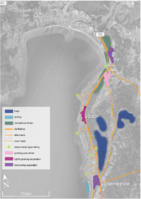
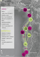 map of risks and potentials in the area

B.4 Theory reflection
The major limitation we found when assessing the area was the size of it, around 35 km of coast. This was slightly harder for us to manage, but at least we tried and learned something new. The second limitation is at the same time one of the biggest advantages and turns out as a great possibility for the area, it is the diversity of the landscape characters and various habitats. During this phase we all learned about different assessing methods, although the group members who don't have a background in landscape architecture, learned the most. For our assessment we chose to use a SWOT analysis which might seem very basic but we find it clear and useful, also ecosystem services analysis which was new to all of us and we thought it made sense to be used in our project mostly because of the very diverse landscape. And probably most important was the Landscape character assessment which some of use were already familiar with. We decided to focus this assessment slightly differently to reflect the various protection areas and different levels of protection since it is such a major topic in our area (different levels, causing restrictions and limitations to people and farmers and so on).
B.5 References
- give a full list of the references you have used for this section
- "http://www.ilmateenistus.ee/wp-content/uploads/2014/05/Maljutenko_20140321.pdf
- "maaamet; www.maaamet.ee
- "google maps; https://www.google.ee/maps/@58.2384838,24.6779944,11z
Phase C – Strategy and Master Plan
C.1 Goal Setting
- Define strategic planning objectives based on the evaluation findings
- Link back to your original targets from section one and the Development Goals
- 150 words text contribution
-
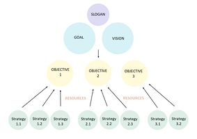 Diagram showing the organisation of the planning

SLOGAN : Over the 7 lands and the sea
GOAL : Eco-tourism infrastructure is developed to promote and emphasize areas diverse landscape characteristics. Coastal meadows special for this area are kept and considered an attractive land use and the place is a desirable place to live offering everything needed to its rising population.
VISION : Existing landscape values are preserved and kept. Locals take part in development and maintenance of the area which is peaceful and picturesque to live, various habitats are safeguarded for wildlife but accessible and open to tourism with appropriate recreation infrastructure. Sea brings job opportunities, and its affect are not a threat for people living on the direct coast
OBJECTIVE 1 : Keep existing distribution of land use to ensure stabilisation of agriculture
STRATEGY 1.1 : All coastal meadows are at least in same volume and are maintained accordingly by grazing.
STRATEGY 1.2 : Agricultural areas are in its current volume and are maintained in an ecologically and economically sustainable way.
OBJECTIVE 2 : Develop of eco-tourism to create job opportunities and promote the area for recreation and education.
STRATEGY 2.1 : The area offers a wider range of eco-tourism services that are led by locals (e.g. fishing, catering, tour guides...).
STRATEGY 2.2 : Creating a good widely spread information system of maps, guide books and other touristic information in form of signs on spot as well as online. Possibly creating themed and educational paths and trails providing information about local culture and nature.
STRATEGY 2.3 : Develop and increase the already existing small local scale harbour infrastructure and creating opportunities for individual docking.
STRATEGY 2.4 : Views are open to the coastal area, bushes and underwood is cut where it is odd.
OBJECTIVE 3 : Manage the coastline to preserve special habitats and avoid erosion effects.
STRATEGY 3.1 : Educating locals and land owners, policy makers and public servants by introducing erosion effects, flood risks and management of these due to previous experience with erosion occurring only because of lack of knowledge.
STRATEGY 3.2 : Create new publicly accessible spots and connections to the direct coast to increase coastal accessibility and raise awareness of different types of the coast. This should promote care and maintenance of these special characters (e.g. meadows, stony beaches, sandy beaches, pine forest on the coast…) and focus people in areas with lower sensibility.
C.2 Spatial Strategy and Transect
- translate your strategic goals into a vision
- develop a spatial translation of your vision
- exemplify your vision in the form of a transect with concrete interventions
- add map(s) and visualizations
Transect of our area leads through the more southern part of or case study area, near Rannametsa and Võidu. This area has been chosen for the transect because it shows all the divers habitats and landscape characters represented in the whole area. It has a little bit of everything (beach, costal meadow, agricultural land, sand dunes, pine forest, bog and urban area). It also shows how the land is separated in two by the sand dunes and existence of Via Baltica road.
With our small interventions and an example of their placement in the transect we would like to visually and physically connect these two sides. This would offer overall connection not only along the coast but from inland to the sea as well. for example a hiking trail going through the bogs all the way to the sea. All the small interventions planned for this area would be in form of simple tourism infrastructure that would not only enhance the comfort of visiting the area but maybe also be a reason to come (for example view towers and platforms.
Our examples of interventions are inspired by the shape of a local traditional boat. They have a simple clean design and white colour to stand out, only the shape is inspired by the boat. This imaginary boat has been separated in three pieces and a spread across the hiking path for a few reasons. The firs being simply to "motive the hiker to find the rest of the boat" and to create curiosity. Other factors this design should remind us of, is the presence of sea, fishing and a certain past and culture of the area, hence the traditional shape and also the presence, change and continuity of water in different forms in the landscape.
-
Spatial translation of our vison and planning
-
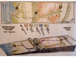 Transect of the area leading through various habitats
 -
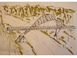 Bridge as an intervention to help connect two sides of the transect separated by a busy road
 -
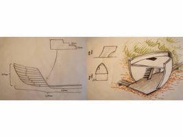 Local boat shape inspired viewing platforms


C.3 From Theory of Change to Implementation
- For implementing your vision: Which partnerships are needed? Which governance model is required?
- Who needs to act and how? Draw and explain a change/process model/timeline
- Which resources are needed? On which assets can you build?
- add 150 words text and visuals
First of all the partnerships needed starting from the government, local people, NGO-s, nature protection, Environmental Board and to other legal authorities… On the Governance model we concentrated on the three major components. First the Decision makers: local government, Environmental Board other legal authorities Secondly Operating procedures: new comprehensive plan, landscape architectural solutions, detail plans, seminars and joint works with locals (also students), hikes around the area, public polls. (Vision management plan, management of cooperation, risk management, communication management) And finally the Cooperation: between the parties. Local government, local people, NGO-s, nature protection, Environmental Board and to other legal authorities… The actions to be done are divided as follows. Local government - take the lead to make positive changes and decisions, advise people who to act, make decision making possibly easy and clear to be attractive for quick initiatives. Local people - come up with ideas and communicate them to local government, realize the ideas, be active NGO-s - take the initiative, come up with ideas Nature protection - monitor the state of protected areas and habitats where new development have planned, give an advice to locals and municipality Legal authorities (eg. Environmental Board, Estonian Road Administration) - give legal advice and supervise the current situation and planned development The resources needed to make it work are directly associated with competence required like civil engineers, environmental specialists, biologist (both marine and inland). By explaining the situation and involve the locals in the planning process. The transparency of the processes is equally important.
-
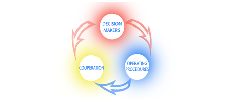 coordinated interactions between the components
 -
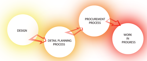 the sequence of processes needed for implementation


C.4 References
D. Process Reflection
- Reflect in your intercultural and interdisciplinary team on the outcomes of your study
- Which limitations were you facing?
- What have you learnt from each other?
- What would you do differently next time?
- You can also use diagrams/visuals
- 250 words text