File:Grenne and bleu Infrastructure.jpeg

Original file (4,335 × 2,567 pixels, file size: 908 KB, MIME type: image/jpeg)
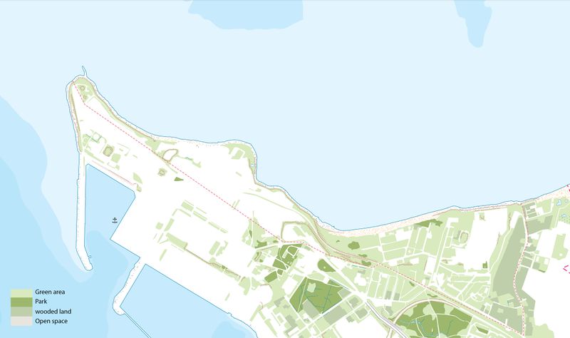
The KOPLI bay presents a generally green character and a relatively flat topography.
Reading the green infrastructure map allows us to identify three components: - A park located in the south of the bay named Susta-Park, with an area of 8 ha. It's characterized by its landscape diversity with wetlands, wooded areas and rocks. - Areas of lawns, planted with small scattered trees, located mainly at the seaside and to the east. - Wooded wetlands, marked on the map in (blue-green)
As for the blue infrastructure of Kopli it consists of two elements; - The running water of the sea from a shallow depth of 0 to 5 m - Stagnant water, especially large wet spots punctuated on the site.
Today, the urbanization does not stop widening to the detriment of existing green spaces and fragment the space.
File history
Click on a date/time to view the file as it appeared at that time.
| Date/Time | Thumbnail | Dimensions | User | Comment | |
|---|---|---|---|---|---|
| current | 07:05, 5 April 2019 |  | 4,335 × 2,567 (908 KB) | Najoua.saadi (talk | contribs) | |
| 06:47, 5 April 2019 | 2,480 × 754 (1.24 MB) | Najoua.saadi (talk | contribs) | The KOPLI bay presents a generally green character and a relatively flat topography. Reading the green infrastructure map allows us to identify three components: - A park located in the south of the bay named Susta-Park, with an area of 8 ha. It's c... |
You cannot overwrite this file.
File usage
There are no pages that use this file.