Case Study D: Professorite küla
>>>back to working groups overview
| Area | Professorite küla | |
| Place | Kopli peninsula, Tallinn | |
| Country | Estonia | |
| Topics | Land use and green and blue infrastructure | |
| Author(s) | Alexandru Milea ; Patrizia Eben ; Jonas Löhle ; Mastane Mahfouzi ; Marie-Laure Druet ; Kaidi Pintmann ; Andra Birica ; Irina Midoni | |

| ||
Rationale
Professorite küla is an area of the South sea side of Kopli peninsula, located on the North of Tallinn. Its main characteristic is the presence of a strong historical past throught various buildings such as the school wich gives the name of the area and is a final point of the main road, the industrial buildings linked to the port acivity and the private wooden houses with their garden. This mixity and the inaccessibility to the sea physically (views are available) is a problem for the good quality of life because of some abandoned buildings which bring an unsecurity feeling. The main challenge in this area is to find a balance between the growth of industry and their move into land because of the water level rise, the need of housing to improve the quality of life and the keeping of the green public spaces which can be the solution of the pressure of both industry and housing sprawls, and which can be considered as buffer zones.
Location and scope
You can edit this map with the map editor
A Landscape System Analysis
A.1 Landscape layers and their system context
Geomorphology, landscape units and coastal typology
Professorite küla is located in Kopli Klint Peninsula.The ridge is mostly buried under sand and therefore not traceable in the topography despite its remarkable height (40–100 m). The geology under the Professorite küla area is made up of rocks and sediments of Cambrian age represented by fluvioglacial sediments deposited and „blue clay” terrace. The substrate into which the buried valleys were carved is made up of hard sedimentary rock. In the study area are found industries, public spaces/park and residential spaces; this is an urban area. Professorite küla has a heavy anthropogenic pressure. The principal drivers in the area are geomorphological processes (waves, storms, tides, ice and erosions) and industrial activities. The wave activity and the wind-induced surge during storm events are the principal physical erosion agents. Moraine bluffs of the promontories are eroded during extremely severe storm surge events. The presence of sea ice over the winters and its potential attacks add another dimension to the vulnerability of the coasts. The area has potential to change over the time as it is a subject to many driving forces. [8] [9]
-
 Sea ice in the winter
 -
 Industrial activities in Kopli Bay
 -
 Tallinn Klint map


Land use
Historically, Kopli peninsula was covered by an oak forest. At the beginning of the 20 century, the Russian Embassy decided to establish a new military fleet (port of war, maritime security and shipbuilding facilities). As a result, port and industry area are present at the end of the peninsula (limit west of Professorite küla site) and on the South side coast of the peninsula (in purple on pictures). Between those two areas, a huge tree-filled with private houses along the coast having an access to the sea (green on pictures) gives the quality of life of Professorite küla's site.
In the land use maps from Copernicus, we can see how the port area (pink) present in 1990 turned off nowadays in a mixed area of industrial or commercial activities (purple), keeping the port activities and at the same time, how it has taken more space at the discontinuous medium density urban fabric (red), composed of wooden houses with their private garden and residential buildings (R+3 in average).
We can imagine a future going to the opposite way where industries go away in order to give an access to the sea as before, thanks to the existing potentials on place of the area (open view areas (blue in last map) and abandonned buildings which could be renovated) and where more housing are provided with an access to green and blue public spaces, improved too.
-
![1920 : industry and harbour activity ; tlm_f1748_pisipilt.jpeg; 1930 : othophoto of the Professorite küla and the end of the peninsula [1]](/images/thumb/9/90/Orthophoto_professorite_k%C3%BCla.jpg/109px-Orthophoto_professorite_k%C3%BCla.jpg) 1920 : industry and harbour activity ; tlm_f1748_pisipilt.jpeg; 1930 : othophoto of the Professorite küla and the end of the peninsula [1]
1920 : industry and harbour activity ; tlm_f1748_pisipilt.jpeg; 1930 : othophoto of the Professorite küla and the end of the peninsula [1] -
![Land use 1990 [2]](/images/thumb/1/19/Land_use_1990.jpg/200px-Land_use_1990.jpg) Land use 1990 [2]
Land use 1990 [2] -
![Land use 2018 [3]](/images/thumb/7/75/Land_use_2018.jpg/200px-Land_use_2018.jpg) Land use 2018 [3]
Land use 2018 [3] -
![Situation of nowadays [4]](/images/thumb/d/d1/Land_use_existant_2019.jpg/173px-Land_use_existant_2019.jpg) Situation of nowadays [4]
Situation of nowadays [4]
![1920 : industry and harbour activity ; tlm_f1748_pisipilt.jpeg; 1930 : othophoto of the Professorite küla and the end of the peninsula [1]](/index.php?title=File:Orthophoto_professorite_k%C3%BCla.jpg)
![Land use 1990 [2]](/index.php?title=File:Land_use_1990.jpg)
![Land use 2018 [3]](/index.php?title=File:Land_use_2018.jpg)
![Situation of nowadays [4]](/index.php?title=File:Land_use_existant_2019.jpg)
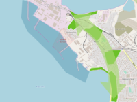
Green/blue infrastructure
Green Infrastructure can be defined as a strategically planned network of valuable natural and semi-natural areas, designed to ensure a wide range of ecosystem services in both urban and rural areas and to protect biodiversity. The green infrastructure aims to create a sustainable relationship between nature and society. Green Infrastructure Strategies seek to sustainably align the underlying systems to prevent irreparable damage to wider ecosystems. A goal is to maintain and improve the functionality of existing, intact ecosystems, to largely remedy defective ecosystems and to create new ecosystems to maintain important ecosystem services and maximize their effectiveness.
The graphic shows the main green elements (consisting mainly of public parks) in the project area and its surroundings. Those elements create a green belt with North-South orientation. From just a few pictures it is hard to estimate the value they provide for a functional green infrastructure with lots of ecosystem services. But still, they are part of it. Also, in my opinion it is not hard to say, that there are almost no blue infrastructure elements within the project are with a natural value. They are all dense built areas with harbours, industrial or military sites (marked with a darker blue).
-
 green and blue infrastructure

Actors and stakeholders
The area of Professorite Küla is located in Tallinn on the Kopli peninsula, where both sides are bordered with harbours and industrial sites. In this case it can be said that the living areas are mixed with industrial areas. There is everything for the living environment- a kindergarten, school, shopping centres, church and also the tram which has good connection with the city centre. Since the very early days Kopli Peninsula has been known as an industrial province where employees were also allowed to live. As the time has changed the interest of residents has shifted as well. These days there is a great interest for developers who see the opportunities to earn remarkable profit thanks to of the beautiful location - the proximity of the sea and the city centre. But developers have to consider local governments’ authority and interests in this area where the ports and industries still play major role. On top of that, one of the branches of Tallinn University of Technology called Estonian Maritime Academy is located in the Professorite Küla which brings young people to Kopli on a daily basis and who revitalize everyday life. [10] [11]
In 2009 non-profit organization Professorite Küla Selts was created by local people and it has a mission - to promote and introduce the life and history of the Kopli Peninsula. They have their own Social Media page and web platform. The organization creates and promotes events to introduce Kopli area with its’ fascinating history. Proffessorite Küla area has also been called the residence of educated people. [12]
-
 Power map of Professorite Küla

Sacred spaces and heritage
-
 As it can be seen in the map, many monuments are located in our project area of the Professors village. The area used to be a huge forest on the outskirts of the inner city, but at the beginning of the 20th century, the peninsula became more and more an industrial area. For military defense large shipyards were built, in which among other things submarines and military ships were manufactured.
 -
 Some of the industrial buildings are still preserved and recognized as heritage buildings. In total, there are around 27 heritage buildings and one historical monument in our working area. However, not only the yards (including e.g. the Bekker shipyard and the Russian-Baltic shipyard) were built, but entire settlements rised around them. They offered apartments and even schools, shopping and other facilities for the workers and their families.
 -
 In particular, the residential buildings of factory officials, managers and engineers are still in a good condition and attractive sights. The beautiful, mostly wooden houses are valued by the city as an important part of Tallinns cultural heritage. This is also were the name of Professors village comes from. Most of the monuments are empty today, but a few are still used: for example the main factory building of the Russian-Baltic shipyard is occupied by the Estonian Maritime Academy today.


Visual appearance and landscape narrative
The landscape character of the area is predominantly defined by two elements, the physical factors defined by the coastal landscape and the industrial heritage in which the human shaped the landscape and adapted it in pursuit of economic growth. The oak forest of the peninsula dates back to 1365. But as is the case with many cities that suffered a rapid growth at the beginning of the 20th century, the peninsula became more of an industrial area, especially thanks to coastal setting and the building of the railway in 1870. When shipyards were built on Kopli peninsula in the early 1912s, most of the coast was rendered inaccessible to the general public in the area. Settlements that included residential quarters, schools, kindergartens, shops, and churches were raised around the industrial area to accommodate the huge number of workers. Parks were also planned as part of the green infrastructure. It was planned to build a representative park in the Kopli Peninsula, but this idea was not realized. Süsta Park is one of the green areas preserved to this day. Even though the settlements are no longer connected with the industrial area. Professor’s Village’ is an area of wooden houses that have survived the decline of Kopli as is seen on the area on the other side of the tram line, as Oliver Orro[15] depicted it.
“Many buildings that have been left vacant have burned down by now or stand in ruins. The original, integrally planned structure of the factory settlement is perishing to a great extent.”
Elements that shaped the landscape during industrialization are depicted in quite a few painting including in the works of Jaan Elken 1981 and 1983 paintings “Paljassaare“[16][17]) and “Kaater”[18].
-
![View of an old building in decomposition nowadays [5]](/images/thumb/1/13/View_of_nowadays.jpg/200px-View_of_nowadays.jpg) View of an old building in decomposition nowadays [5]
View of an old building in decomposition nowadays [5] -
![ДМИТРИЕВ А.И.РУССКО-БАЛТИЙСКИЙ ЗАВОД В РЕВЕЛЕ. 1914 (Dmitriev A.I. RUSSIAN-BALTIC FACTORY IN REVEL. 1914)[6]](/images/thumb/1/1c/Painting_by_russian_painter_1914.jpg/200px-Painting_by_russian_painter_1914.jpg) ДМИТРИЕВ А.И.РУССКО-БАЛТИЙСКИЙ ЗАВОД В РЕВЕЛЕ. 1914 (Dmitriev A.I. RUSSIAN-BALTIC FACTORY IN REVEL. 1914)[6]
ДМИТРИЕВ А.И.РУССКО-БАЛТИЙСКИЙ ЗАВОД В РЕВЕЛЕ. 1914 (Dmitriev A.I. RUSSIAN-BALTIC FACTORY IN REVEL. 1914)[6] -
![View on School Professorite küla in 1913 [7]](/images/thumb/5/54/Professorite_k%C3%BCla_1913.jpg/200px-Professorite_k%C3%BCla_1913.jpg) View on School Professorite küla in 1913 [7]
View on School Professorite küla in 1913 [7]
![View of an old building in decomposition nowadays [5]](/index.php?title=File:View_of_nowadays.jpg)
![ДМИТРИЕВ А.И.РУССКО-БАЛТИЙСКИЙ ЗАВОД В РЕВЕЛЕ. 1914 (Dmitriev A.I. RUSSIAN-BALTIC FACTORY IN REVEL. 1914)[6]](/index.php?title=File:Painting_by_russian_painter_1914.jpg)
![View on School Professorite küla in 1913 [7]](/index.php?title=File:Professorite_k%C3%BCla_1913.jpg)
A.2 Summary of you landscape system analysis and your development Targets
The driving forces in presence are both natural processes and human activities. The main driving force with natural processes is the climate change which includes floods, waves, a strong wind and temperature changes (warmer). The driving forces about human activities concern the urbanization, the tourism linked to the historical buildings and the financial interest. All this driving forces involve some pressures such as geophysical pressures and water level rise by natural processes. Because of the tourism, the popularity can rise which can show a good interest of the site and at the same time, if it too much, loose the identity of the site as well as the urbanization. The financial interest can increase the industry growth and the bad reputation can have an effect on the unsafety of the site. The existing state of the site will be impacted by an eroded shoreline and more flooding area and a large-scale deployment of the coast area by industries. As a result, less housing will be there, the population will decline, the quietness of the place will disappear and the accessibility to the sea will stay inexistent. Consequently, some responses have to be found. The renovation of old historical building or abandoned industrial building can improve the popularity of the site as well as the quality of life by offering an access to the sea for everyone and by avoiding the artificialisation of the coastline. Avoid the sprawl of industry and housing in order to protect green public spaces can be another response to keep the identity of the site.
-
 DPSI(R)
_1.jpg)
As we have seen with the DPSI(R), in the future, the level of the sea will rise generating a move of industry into land as the scheme shows, even if it is a movment already existing. As a result, there will be less housing, less green public spaces and an increase of unsafety. At the end, we will see the place disappear. Our hypothesis is to find a balance between the sprawl of industry, the need of housing which improve the attractiveness of the site and the protection of green public spaces, part of the green infrastructure forming a North-South belt along the site. The idea is to use green and blue infrastructure as buffer zones to give access to the sea for inhabitants and visitors as before and at the same time, renovate old historical buildings to improve the quality of life and bring more people.
-
 Hypothesis if we do nothing

A.3 Theory reflection
- Reflect on at least three international policy documents in relation to their local landscape case
- choose one international, one European and one national document
- You can choose references from our reading list
- Scope: 250 words
UN Sustainable Development Goals:
-
 The Sustainable Development Goals, reference: https://blogs.sas.com/content/sascp/2018/09/25/embracing-sustainable-development-goals-with-free-resources/

The United Nations describes 17 goals for a better and more sustainable future we should achieve until 2030. One of the goals which is relevant for our project area is to make cities inclusive, safe, resilient and sustainable in order to deal with the challenge of urbanization (goal 11). Another target (goal 9) is to build resilient infrastructure, promote sustainable industrialization and foster innovation. Additionally, the goals 14 and 15, which refer to life on land and below water, are important features for our area. Global resources such as water or forests need to be managed carefully and sustainable. The loss of biodiversity and degradation of land needs to be halt, and these are just a few of many targets. The sustainable development goals do not only relate to climate and environment, but to aspects such as poverty, inequality, prosperity, peace, and justice as well. [19]
European document :
In the same way of sustainable development goals, the European Coastal and Marine Policy highlights some risks present in our site such as the sustainability of maritime and coastal activities. It shows us the importance of integrated coastal management in the planning process by asking state members to map human activities and imagine there future spatial development. It’s known that the coast is rich in biodiversity and part of an ecosystem as well as humans activities which can, unfortunately, destroy or disrupt it. For this reason, the Directive 2001/42/EC has been written as an assessment of the effects of such maritime and coastal activities. In our case of Professorite küla site, we have to verify the impact of the industrial areas on the coastal landscape and how it could be made better [20].
National document :
The maritime spatial planning of Estonia bring forth the important effects of the marine space in Estonia. This is the long-term planning which takes equal consider of social, economic, cultural and environmental impacts and needs. The objectives of the maritime spatial planning derive from sectoral development plans, strategies, EU directives and other documents that guide the development of marine space. This document is the plan of the National Plan of the Republic of Estonia, initiated on May 2017, which is the starting point (LS) of the Estonian maritime spatial planning. The aim of the maritime spatial planning is to implement spatial needs in the fields and to balance the areas in the marine space. There is a need to preserve and enhance the recreational and tourism values of the sea and coastal areas, including the preservation of already existing values such as fishery, location-based values and economic activity. Based on the document, we should consider all the principles of marine planning in Professorite küla site. The most important principle of our site is the blue growth and balancing interests. [21]
A.4 References
Geomorphology, landscape units and coastal typology
- https://www.google.com/maps/
- http://www.en.geoview.info/
- http://copranet.projects.eucc-d.de/files/000112_EUROSION_Tallinn.pdf
- https://www.researchgate.net/figure/Location-map-of-the-study-area-investigation-wells-and-hydrogeological-cross-section-of_fig2_229001063
- https://www.looduskalender.ee/klint/eng/13.html
Land use
- https://www.muis.ee/museaalview/153418
- https://land.copernicus.eu/pan-european/corine-land-cover/clc-1990
- https://land.copernicus.eu/pan-european/corine-land-cover/clc2018
- https://www.google.com/maps/place/Professorite+k%C3%BCla,+11712+Tallinn/@59.4597221,24.6562001,2571m/data=!3m1!1e3!4m5!3m4!1s0x469293fa778020ed:0xfed396432241eeb0!8m2!3d59.460117!4d24.6669229
Actors and Stakeholders
- https://www.facebook.com/Professorite.Kyla.Selts/
- https://www.urban.ee/pdf/15/U15-6-ee.pdf
- https://www.tallinn.ee/est/Kopli
Sacred spaces and heritage
Visual appearance and landscape narrative
- https://www.arhitektuurimuuseum.ee/en/naitus/kopli-sonata-the-russo-baltic-shipyard/
- https://digikogu.ekm.ee/ekm/search/oid-8663/?searchtype=simple&searchtext=Jaan%20Elken&offset=1
- https://digikogu.ekm.ee/ekm/search/oid-8664/?searchtype=simple&searchtext=Jaan%20Elken&offset=1
- https://digikogu.ekm.ee/ekm/search/oid-8660/?searchtype=simple&searchtext=Jaan%20Elken&offset=1
- https://m.facebook.com/Professorite.Kyla.Selts/photos/a.1515697078512086/1515697191845408/?type=3&source=54
- https://www.spbmuseum.ru/funds/321/3489/?fbclid=IwAR0EOJe6JV-SQhLlbEpkkyu_Fyf0Jow2PCI5Ut-Sr4wLrUnHAGFIdOiNwnw
- http://extrazoom.com/image-46083.html?fbclid=IwAR3_sNMkSAJ2GFihzW58zP6neuDcyKsIoc-I1UGai8YxXdm42z47d3xjtG0
Theory reflection
- https://www.un.org/sustainabledevelopment/sustainable-development-goals/
- http://ec.europa.eu/environment/iczm/index_en.htm?fbclid=IwAR2hbOYRVfWY5BWai_EbTaCKswL1gy2Z9Txz7CHGSjQ8uko5OeMPpsLOLPI ; http://ec.europa.eu/environment/iczm/prop_iczm.htm ; http://ec.europa.eu/environment/eia/sea-legalcontext.htm
- "https://www.rahandusministeerium.ee/sites/default/files/2018-04-11_msp_ls_ja_vtk_seisukohtade_esitamiseks.pdf"
Phase B: Landscape Evaluation and Assessment
B.1 Assessment Strategy
- Based on the hypothesis derived from your previous landscape systems analysis you are now asked to define the goals for assessing the landscape. Your assessment is the basis for evaluating the landscape status.
- Which elements and phenomena need to be mapped, why and how?
- This a text contribution, max 250 words
Based on the Landscape System Analysis of Professorite küla, the main problem is there isn’t any public access to the coastal line in the site. However, some views give us the idea of the presence of the sea. Moreover, all the cost is taken by the industry which are part of both the history and the economy of the site even if lots of buildings are abandoned, which increase the unsafety feeling, as we saw before, and those avoid connections between two living areas, one composed mainly of individual housing with private gardens and the other one composed of residential and collective buildings with little open green public places.
Based on the previous information and analysis is important to map :
- The Landscape Characters Assessment and the Coastal Landscape Assessment in order to understand the complex diversity of our site by an understanding of the components of its identity and start to see where are located problems or potential areas.
- The roads associated with both physical and visual access to the sea in order to see if there is or not good access into Professorite küla site in general.
- Recreational areas and cultural historical elements to highlight the attractiveness of Professorite küla and its localisation into the all peninsula.
All these elements will be mapped at the Kopli peninsula scale in order to show that Professorite küla site in an integrated part of the whole peninsula landscape and its development have to take into account that purpose.
B.2 Mapping
For the Landscape Characters Assessment and the Coastal Characters Assessment we have chosen to make two maps because of the complex diversity of Professorite küla site. The first one shows the main characters through fives units LCA and 3 units CCA - (orange) Artificial beton coast line / (North coast) Natural gravel and pebble beach / (South coast) Sandy opened recreational beach - while the second one shows 8 units LCA defining 2 types of industry and commercial areas, 3 types of living places, the services areas as well as green spaces and sports areas.
-
 Landscape Character Assessment (LCA) and Coastal Character Assessment (CCA)- Industry + commercial activities / Residential area / Historical area / Recreational area / Services area. On the first map, we can see that Professorite küla site is mostly historical with large industrial area but offers residential and recreational areas too.
 -
 Landscape Character Assessment (LCA) and Coastal Character Assessment (CCA)- Harbour activities / Offices link to commercial and industry activities / Housing with private gardens / Residential buildings with one little open green space and some open playground / Residential buildings with many open green spaces and some open playground / Green spaces composed of parks and open green spaces / Sports area / Services area. On the second map, we can see that services into Professorite küla or closed to it are located along the main road and public transports (tramway and bus), which link the different types of living areas. Through these two maps LCA and CCA, we can see that the main characters are historical and recreational with an economy turned to industries and local services showing a complex diversity but at the same time enhancing the social life.
 -
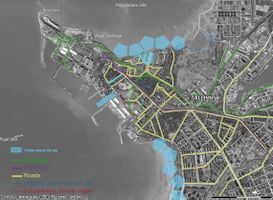 Accessibility with possible views to the sea from Professorite küla site. Generally, our site is quite accessible thanks to the tramway (30 minutes from bus station), buses, a main road along them and secondary roads which give access to living places even if some are not totally accsessible because they finish into industry area. Some walking paths are existing, mostly into green spaces. Nevertheless, the access to the sea isn’t possible yet in Professori küla site because of industry but some views are given to visitors and inhabitants, which is a good potential for our site, as you can see on the map. Its location at the end of the tramway gives to our site a feeling to be a starting point for walking paths toward the north coast into the site Kopli liinid thanks to all spots where the sea is visible as well as the South coast (farther).
 -
 Recreational areas and cultural historical elements. The hotspots combine many different features. In our project area the hotspots consit of sports, recreation, nature and cultural heritages. As a result, professorite küla site can be seen as an attractive point into a bigger walking path which can cross over the different green spaces of the Kopli peninsula and linked historical cultural heritage components.


B.3 Problem definition and priority setting
- Give a summary of the major findings of your mapping process, what are the problems/potentials identified?
- Draw a problems/potentials map
- Set priorities for the most relevant issues
Thanks to previous maps we can see that the main problem concerns the mixed character of the area and the fact that industry take all the coastal area of Professorite küla, privatising the accessibility to the sea by an artificialisation of the coastline. Moreover, a lot of buildings have a bad quality or worse, some are abandoned, increasing the bad reputation of the area.
Nevertheless, such area can be seen as a potential by restoring or giving new services such as sport, restaurant (at the 2nd floor or on top of the building) to offer nice views on the sea above industries. Those services are linked to the existing ones and strengthened the recreational character of Professorite küla site. In this same idea, all green spaces and sport areas are good potential to improve hiking and biking trails through all the Kopli peninsula.
One open space into industry area, especially offices areas (e.g. LCA map 2) and composed of grassland and few trees, can be a potential place to give an access to the sea to everyone, both inhabitants and tourists, as well as offer them pleasure activities such as a marina or fishing place.
For example, if after three or five years, the municipality see that recreational services don’t work in renovating buildings, the place could be given again to industry, to improve their economy.
-
 Problems and potentials map

Goals for the planning and design process of the Professorite Küla site :
- Give attractiveness to the site by avoiding bad quality of architecture as well as the abandoned ones
- Strengthen the recreational character of the area by adding new areas offering different services
- Develop walking and biking trails as connection to all green public spaces, sport areas or cultural spots both recreational areas of the kopli peninsula
- Give an access to the sea and promote accessibility to the other coast line.
B.4 Theory reflection
- Please reflect the assessment and evaluation methods used based on at least three readings
- Did you encounter limitations'
- 200 words test contribution
Insights got from lectures :
- Method of analysis (LCA/CCA, both scenarios and ecological, socio-economic services even if we haven’t map them it help us to find the point of view to take in - Professorite küla site)
- Concept of green infrastructure
- Examples of maps
Use the methods of both Landscape Character Assessment (LCA) and Coastal Landscape Assessment (CCA) seems to us as necessary for a better understanding of Professorite küla site. Indeed, these methods are used in order to identify the distinctiveness or the uniqueness of an area by answering at the question “how the landscape is composed?”, or in others words, “how the landscape appears to us?”. So as to qualify the area and divide it into different units, we have to analyse each component of it, both natural and human, such as the topography or the geology, the green infrastructure, the hydrology, the land use, the roads and the settlements. The character results of their combination as explain in [22]. Even though an LCA or CCA can be done at different scales, as explain in [23], for our proposal we have decided to work with the outlook of an area as much detailed as possible for an understanding at the local level defined for us as the whole kopli peninsula, without forget to think about links with Tallinn (e.g. maps of accessibility).
Limitations :
There were two types of limitations during this second working phase. Ones inside the team work (no communication and little participation in general) and others ones coming from outside such as, the hardness to find information (point of view of people or building which are really abandoned or those which are just in bad quality for example) and the complexity of Professorite küla site.
B.5 References
- https://www.openstreetmap.org/
- https://www.google.com/maps/
- https://assets.publishing.service.gov.uk/government/uploads/system/uploads/attachment_data/file/691184/landscape-character-assessment.pdf
- https://www.nature.scot/sites/default/files/2018-07/Guidance%20Note%20-%20Coastal%20Character%20Assessment.pdf
Phase C – Strategy and Master Plan
C.1 Goal Setting
- Define strategic planning objectives based on the evaluation findings
- Link back to your original targets from section one and the Development Goals
- 150 words text contribution
The intensive week in Tallinn allowed us to redefine our goals explained previously on phase B :
- Give visible the identity of the site by organizing its diversity and mixity.
- Protect and improve the green infrastructure.
- Give physical accesses to the sea and keep the quality of the visual ones.
- Improve the connectivity/accessibility into the site (create a connection East-West through the site, inexisting yet).
All those goals answer to a need of an understanding of the area by organizing all the present functions (housing, facilities and industries) as well as a need of a better life by taking into consideration both blue and green infrastructures. That are the reason why we can linked them to four main sustainable development goals such as "Life of land n°15" [24], "Sustainable cities and communities n°11" [25], "nNo poverty n°1" [26] and "Decent work and economy growth n°8" [27].
All of those themes are very important to resolve the existing problems in Professorite küla site as well as enhance its values.
C.2 Spatial Strategy and Transect
- translate your strategic goals into a vision
- develop a spatial translation of your vision
- exemplify your vision in the form of a transect with concrete interventions
- add map(s) and visualizations
Vision : Revive the heritage through Professorite küla site
-
 Overall concept map of Kopli peninsula

Professorite küla site is part of a general concept through the whole kopli peninsula where each concept of each site constitute a key point of its identity. Each site have some interactions and are linked together through both the green infrastructure and the coastline by taking into account the human life.
Following this overall concept, in Professorite küla site we have decided to create a green corridor along the unused railway which linked our are from Kopli lines on the North to Cemetery site on the East which go into the coastline. Indeed, we have opened two main physical accesses to the sea and a third one as a continuity of the second. Then, we improve the pedestrian connectivity of the site from West to East, keeping car in both side of the green corridors but not into it. All those interventions can be possible by reducing both shipyard and industry areas in order to create more dwelling places and a new sort of zones refering to the identity of the site : mixed areas (offering facilites, offices and housing).
-
Green structure throw the notion of green corridor
-
Physical accessibility to the sea
-
Connecting road network with acttractive heritage point
-
master plan
To go into more details, we also decided to keep industrial buildings, main part of the identity of the site by renovating and giving them news functions as we have shown in mixed areas. We define them as acupuncture points into Professorite küla site which gather people, both workers and inhabitants.
-
Transect of the site from residential area near Cemetery site to Sütsa park
-
Cultural center and green corridor
-
revived social interaction
-
An entrance landmark as viewpoint
-
Ruins showing the access to the sea
C.3 From Theory of Change to Implementation
- For implementing your vision: Which partnerships are needed? Which governance model is required?
- Who needs to act and how? Draw and explain a change/process model/timeline
- Which resources are needed? On which assets can you build?
- add 150 words text and visuals
-
add caption here
-
add caption here
C.4 References
- give a full list of the references you have used for this section
D. Process Reflection
- Reflect in your intercultural and interdisciplinary team on the outcomes of your study
- Which limitations were you facing?
- What have you learnt from each other?
- What would you do differently next time?
- You can also use diagrams/visuals
- 250 words text