COLAND Case Study 2020 - Al Mina, Lebanon
thumb >>>back to working groups overview
| Area | Al Mina | |
| Place | Tripolis | |
| Country | Lebanon | |
| Topics | Environmental and Social layers of El-Mina's coastal landscape | |
| Author(s) | Celine Semaan, Luna Mansour, Yara Sleem, Lujain Maddah, Mario Abu Shaar, Carine Bitar | |

| ||
Rationale
- 'The coast of Al Mina is mostly sandy. This coast is also interactive, causing the people to have a strong relationship with the water. Moreover, the coast is accessible, where many fishermen come to this coast, and people access it to spend time. Our aim is to bring back this strong relationship between the people and the coast, and increase accessibility. in addition, taking care of the erosion at the coast by rehabilitating the area.
Location and scope
You can edit this map with the map editor
A Landscape System Analysis
A.1 Landscape layers and their system context
Geomorphology, landscape units and coastal typology
The coastal landscape of Al-Mina changed and developed over the years, with the urban sprawl happening. Moreover, the infrastructure on the coast is old and slowly deteriorating. The Al-Mina coast consists of 3 main parts, the man made parts, the rocky parts ( verimitidae platforms) and the sandy dunes. As seen, the vermitidae platforms are the most present around the coast, but slowly, a lot of man made harbors are taking over, making the coast more constructed and geometric rather than being kept at its natural state. It is important for the natural ecosystems, that these vermitidae be protect by all means. These rocky platforms are living shells that decrease the chances of tsunamis and high waves on the shore.
-
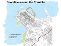 Coatal Typology
 -
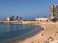 Picture of the Al-Mina Coast


Land use
This map shows the landuse along the Mina coast. Different activities happen along this coast, making it a coast that is diverse, making it more attractive to people from all ages and generations.

Green/blue infrastructure
Main element Al-Mina and Tripoli is the Abu Ali river and the seasonal streams present. moreover, green space do exist in Al- Mina and Tripoli, however in a very low percentage and in small areas, not large public place where people can gather and meet.
-
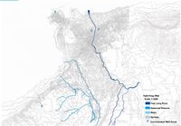 Hydrology of Al-Mina - Blue infrastructure
 -
 Green spaces of Al-Mina - Green infrastructure


Actors and stakeholders
-
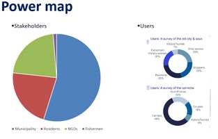 add a caption

Sacred spaces and heritage
Mina, Lebanon has very strong traditions and crafts that have been significant and present for decades. Due to Mina’s geographical location, it is heavily known for its fishing activities, which eventually lead to various stores and restaurants regarding this idea. Additionally, Mina has a very prominent culture in arts and crafts such as pottery, copper, and cloth making. These arts supported the city of Mina economically and socially for the years.


Visual appearance and landscape narrative
Who has written about Mina?
- Thesis done by Thanaa ElHelwa
- Thesis done by Ghadir Ghamrawi
- Publication & Studies done by John Touma & co.
- Study done by Unesco (world heritage)
- Testemonies collected by Abdallah Kabbara
- Diaries & Testemonies by John Touma & co.
-
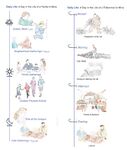 Landscape Narratives

A.2 Summary of your landscape system analysis and your development targets
- Driving Forces:
-Coastal Erosion
-Sewage Outlets
-Solid Pollution
-Urban Sprawl
-Landfills
-Dissociation from the Urban Fabric
-High Poverty Rate
- Hypothesis:
-Urban Sprawl taking over the landscape
-Sea Pollution due to uncontrolled sewage
-System and solid pollution
-Degradation of sea coast due to erosion

-
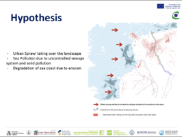 Hypothesis

A.3 Theory reflection
- Reflect on at least three international policy documents in relation to their local landscape case
- choose one international, one European and one national document
- You can choose references from our reading list
- Scope: 250 words
A.4 References
- give a full list of the references you have used for this section
Phase B: Landscape Evaluation and Assessment
B.1 Assessment Strategy
- Based on the hypothesis derived from your previous landscape systems analysis you are now asked to define the goals for assessing the landscape. Your assessment is the basis for evaluating the landscape status.
- Which elements and phenomena need to be mapped, why and how?
- This a text contribution, max 250 words
B.2 Mapping
Three mapping themes are included:
- The environmental perspective
- The mobility perspective
- The economic perspective
-
 The environmental perspective
 -
 The mobility perspective
 -
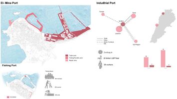 The economic perspective


B.3 Problem definition and priority setting
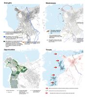
Many strengths are found in Al-Mina and many opportunities are present. Nevertheless, weaknesses and threats are still a part of this coastal city, making it more challenging for us to work with.
-
 add caption here

B.4 Theory reflection
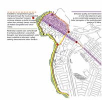
- Develop environmentally-resilient solutions that take into consideration the natural and man-made erosive factors, the sewage outlets, and the sensitive habitats of the coastal landscape
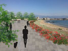
Enhance pedestrian accessibility and transportation along the promenade and the coastal road
Strengthen the city’s relationship to the seafront through re-envisioning the promenade and allowing public and inclusive accessibility to the coast
Utilize resources available in the coastal landscape for sustainable, economic development
CRITICAL REFLECTION Limitations include:
Environmental degradation of the coastline
Poor condition of the current promenade
Socio-economic status of the population (majority: low-income)
Overpopulation of the city
B.5 References
- give a full list of the references you have used for this section
Phase C – Strategy and Master Plan
C.1 Goal Setting
- From an Urban Morphology Perspective: (SDG: Clean Water, Clean Energy, Industry and Infrastructure, Sustainability )
Introduce green and blue infrastructure "
- From a Mobility Perspective: (SDG: Sustainability)
Provide good transportation system Develop coastal road and pedestrian movement "
- From an Infrastructure and Economy Perspective: (SDG: Economic Growth, Industry and Infrastructure, Life Under Water)
Provide good roads Increase the economy through exporting from the port Provide work opportunities "
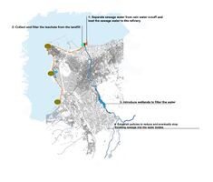
- From an Environmental Perspective: (SDG: Clean Water, Good Health, Clean Energy, Responsible Consumption, Climate Action, Life Under Water, Life on land )
Provide clean water to the citizens Divide sewage water from the rain water runoff Collect and filter the leachate from the landfill ‘ Generate energy from waste
C.2 Spatial Strategy and Transect
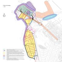
Having different strategies, on different scales, allows us to understand more the coast, and it relationship to its surrounding. Possible areas of intervention are proposed, where the main aim is to restore the landscape, decrease erosion, and decrease pollution along the Mina coast.
-
 strategic goals for Al-Mina
 -
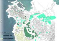
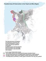 possible areas of interventions in Al-Mina, Tripoli
 -
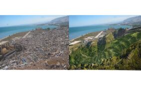 intervention 1:landifill
 -
 intervention 2: coastline


C.3 From Theory of Change to Implementation
- Partnerships Needed: Mina Municipality, Tripoli Municipality, USAID, Ministry of Health, Ministry of Environment, Nurseries, Environmentalists, Water Specialists."
- Involvement: For a better project design and implementation, the local community needs to be involved in the working process through workshops, trainings and awareness campaigns."
- Resources: Research and studies on the previous and existing conditions of Mina to provide a clear futuristic plan of Mina. Research and studies to create an overall city strategy for a more sustainable and developed Mina.
-
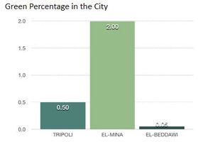 percentage of green spaces in Tripoli, Al-Mina and El-Beddawi
 -
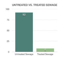 untreated sewage vs. treated sewage in Tripoli and Al-Mina


C.4 References
- give a full list of the references you have used for this section
D. Process Reflection
- Mina has proven to be a challenge due to many stakeholders involved: projects need to be responding to everyone’s needs.
Mina Municipality wasn’t cooperative as much as we hoped, they are financially unable to implement any project. 40% of Mina families are under the line of poverty which leads them to be uninterested in implementing projects that don’t generate profit. For a better outcome, the interaction with Mina residents and locals should be enhanced in order to understand their needs and use it for better projects ideas.