COLAND Case Study 2020 - Manara, Lebanon
>>>back to working groups overview
| Area | Manara | |
| Place | Beirut | |
| Country | Lebanon | |
| Topics | please enter the main coast-related topics here | |
| Author(s) | Lama Amin, Julia Abisaab, Nour El Zein, Andrea Hadwan, Hani Abdallah | |

| ||
Rationale
The case study at hand is relevant for many reasons, the most major reason however is its existence within a dense, urban context that is facing rapid urbanization and is at risk of being privatized in the near future, facing the challenge of managing urban open spaces. Our hypothesis considering the landscape challenges is that if things play out as usual, we will see rapid urbanization within the coming 10 years, which will destruct the whole coastal rocky/natural landscape as well as the social aspect of the area.
Location and scope
You can edit this map with the map editor
A Landscape System Analysis
A.1 Landscape layers and their system context
Geomorphology, landscape units and coastal typology
- Description of evolution, status quo and driving forces, is the coastal typology changing? Why is that? (approx 200 signs)
With time the coastline has developed greatly due to the weathering away of the rocky outcrop. With urbanization also there has been great manipulation to the coastline from forced ports to illegal construction on public domain. The morphology of the site has evolved greatly due to the changing climatic conditions and human induced issues as seen in the evolution diagram (1842-2000). The Beirut geology exhibits how the site is mainly dominated with Well bedded limestone with few calcareous shale intercalations, bedded, and jointed (C4). The other geological typologies are: Sandstone/fixed dunes (qd); (qdm) sandy/shifting dunes (qdd) sandstone / red sandstone
-
 Historical Evolution of Beirut Coastline: 1842-2000 (Source: Najjar&Najjar)
 -
 Beirut Geology


Land use
- Beirut city, capital of Lebanon, is the highest attraction for most travelers. The city itself is highly populated and highly built with few green open spaces for the public. Although the case of Beirut is not optimistic in terms of the open landscape areas but one area, Manara, one of the most visited areas daily. The Manara strip is a hub for social interactions and physical activities mainly. The space is one of the longest stretches of public space, composed of a wide sidewalk, a strip of palm trees, benches. It is a simple design and people seem to admire its simplicity whereby open for them for any activity they desire. Manara is highly advertised also for its private spaces and for the touristic areas such as the theme park, the restaurants, the resorts, the sports centers. Across from these public and private points across the Manara coastline, the area is dominated by residential buildings, with some mixed areas of commercial/residential areas.
- As seen in the maps below, the land has been known to be a residential area with some vacant lands, open grasslands/shrubland areas, a beach coast, however within the past years more and more investors and companies have been targeting Beirut for their benefit while the coastline is suffering. The major driving forces are the investors and political dominance over the lands of Beirut. The land may change and become excessively private if more investors target the empty coastline but environmentally the coastline may end up disappearing due to its geological background. The unlikely scenario is if the laws governing the are are to be more strict and remove the violations across the coastline then their may be a chance for a positive landscape development.
-
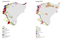 Landuse Evolution: Years 2010-2017
 -
 Manara's Public Strip
 -
 Manara's old residential areas

.jpeg)
.jpeg)
Green/blue infrastructure
- What are the major potential elements of a green/blue infrastructure network? Are these likely to change/disappear? Why is that?
- You find my background material on green infrastructure in our reading list
- add 1-2 graphical representations to the image gallery, you can add more if you like
-
 add a caption
 -
 add a caption


Actors and stakeholders
Previously, Manara was a coast for the public where no building could be constructed that would interrupt the protective abilities of the black and white lighthouse on its hill. The site we are looking at is a stretch of boardwalk that has served as a pedestrian walkway for decades now. In 1995 however, this changed and what was once an area clear of buildings and strictly for the people became colonized by private developers who began building 18-floor buildings in the area. The outcome has left a wall in front of the lighthouse, destroying its functionality and the general aura of the place. In this case it is safe to say that due to private developers, not only was public infrastructure destroyed, but locals lost what was once a public open space due to the interest of private beneficiaries, which now symbolizes the government's demise. It is also important to point out that public spaces in Lebanon are very scarce therefore if policies do not start presenting themselves regarding limits to privatized lands along the coast, we may soon lose public access to Manara for good.
-
 add a caption

Sacred spaces and heritage
- Which places/elements hold cultural value and to whom?
- You may add a map and some images, please also explain in your caption why these elements are valuable
-
 add a caption

Visual appearance and landscape narrative
- Which elements are essential for the landscape character?
- Has the landscape been painted or otherwise depicted, when and whom? Which elements are essential?
- Which narratives exist? Who has written about this landscape or depicted it in some way?
- You can add text and images
-
 Sunset in Manara Beirut has something special. Whether it is the Mediterranean or the weather conditions. The Beirut Corniche is the heart of the city. It is a long seafront promenade lined with palm trees where one can witness true cohabitation and tolerance.There is a wide paved walkway along the Corniche that accommodates runners, walkers, dog walkers, cyclists, and people fishing. The Manara overviews the sea. It is a place where people reach manara to watch the spectacular reflection of the sun on water during the sunrise and sunset. The picture started to tell a story, which became a kind of ambiance to the story. These limestone outcrops just offshore are prime selfie territory and a Beirut landmark. They are impressive; one has an archway eroded through it.
 -
 The Corniche is a must see spot when visiting Beirut. On a weekend or a holiday, you are bound to find a lot of people fishing on the railways of the Corniche. It is interesting to see them catching fish in a city and here you can observe diversity in Manara Beirut between city life, tall buildings, people fishing. The walk is long and enjoyable and it is recommended to get a taste of life in Beirut and to walk along the Corniche.


A.2 Summary of your landscape system analysis and your development targets
We concluded that the main drivers of our DPSIR model were strongly related to urbanization and climate change. Urbanization has put major pressure on this coastal landscape mainly due to commercial discharge which ends up in the sea, affecting clean water and sanitation- point 6 of the sustainable development goals. Urbanization has additionally affected the landscape in terms of pedestrianizing the area through the insertion of street furniture, paving of the walkway with concrete, and fencing the area in order to create a boundary between the people and the sea for "safety measures". This urban component not only breaks the direct connection between people and nature, but also limits the quality of life the area can ensure, leading to a lack of flora and fauna along the coast which worsens each year, putting the 14th and 15th sustainable development goals:life below water and life on land, at risk. Climate change is another factor that exerts pressure on the area in terms of sea-level rise and an overall decrease in both air and water quality, putting goal 13:climate action, at severe risk, especially in Lebanon where close to 0 actions are being taken in order to mitigate climate change in general, let alone along the coast. As for the hypothesis, we surmise that if things go on as they are, that: 1. private investors will get a hold of the coast, meaning it will no longer be accessible to the public and if it is, the accessibility will be monitored and further concentrated in only one area of the coast. 2. further reduction of the natural environment (both flora and fauna) due to the further human interventions that will take place on the coast, as well as climate change factors such as erosion, and rising water levels. Both issues faced in our context are anthropocentric, meaning that they can be avoided if policies are introduced to prioritize both public spaces and natural environments.
-
 DPSIR Model

-
 explain your hypthesis briefly in the caption

A.3 Theory reflection
- Reflect on at least three international policy documents in relation to their local landscape case
- choose one international, one European and one national document
- You can choose references from our reading list
- Scope: 250 words
A.4 References
- https://www.lebanoninapicture.com/pictures/o-convidativo-calcad%C3%A3o-a-beira-mar-de-beirute-corniche-
- https://urbannext.net/metamorphosis-coast-line/
Phase B: Landscape Evaluation and Assessment
B.1 Assessment Strategy
With our hypothesis being that we expect rapid urbanization within the coming 10 years, which will destruct the whole coastal rocky/natural landscape as well as the social aspect of the area, the goals we defined for assessing the landscape are the following: - Acquiring full comprehension of the land's ownership status and its development over time (private/public map in order to realize the rate at which things are becoming privatized) - Realizing the change in accessibility over the years (mapping the accessibility/links of the site, to have an idea of how "public" the site is nowadays as well as how integrated it is with its context vs. how it was before) - Understanding the climate change risks at hand (sea-level rise map in order to understand its effect - although seasonal - on the context)
B.2 Mapping
Themes: (1)Urban Expansion (2)Connectivity/Accessibility (3)Sea-Level Rise
-
 briefly explain the findings of your mapping
 -
 briefly explain the findings of your mapping
 -
 briefly explain the findings of your mapping


B.3 Problem definition and priority setting
- Give a summary of the major findings of your mapping process, what are the problems/potentials identified?
- Draw a problems/potentials map
- Set priorities for the most relevant issues
-
 Problems/Potentials Map

B.4 Theory reflection
- Analyzing Landscape Change and Urban Sprawl in a Mediterranean Coastal Landscape: A Case Study from Izmir, Turkey
-Very similar case to Beirut urban sprawl, the coastline was later interjected with settlements
-This study interprets the temporal and spatial landscape changes that occurred can be projected to develop more-sustainable urban planning strategies for the future of the area -They evaluated the land-use and the change of areas and which major land-uses were affected due to the urbanization period
- Landscape trajectories: sea level rise and future landscape New Zealand region
-Assessment was based on the areas at risk of flooding, extreme weather conditions, climate change will create more extreme events. Beirut still hasn’t suffered from major flooding events across coastline but mainly due to the weak infrastructure ad extreme rain conditions.
-Understanding the forms, practices and relationships of past landscapes help us explore possible trajectories, (1) thinking of ways to regenerate the lost ecological habitats such as lagoons and wetlands due to urbanization, (2) thinking of the current values of the people and their relationships in the landscape, (3) what people are expecting/want from the landscape in the future
-Major theme was to focus on interconnections between the past, present and future landscapes
- Early warning signals for landscape connectivity and resilient conservation solutions
-a holistic resilience‐based framework to identify the early warning points of climate‐gradient landscape connectivity; the results offer the first map capable of providing information about landscape connectivity in the coastal provinces of mainland China
-The magnitude of spatial interactions between human activities and natural habitats is an essential determinant of anthropogenic threats to landscape connectivity, which is highly evident in our case where the human settlements create major disconnections among ecological patches
B.5 References
- https://www.academia.edu/11429002/Analyzing_Landscape_Change_and_Urban_Sprawl_in_a_Mediterranean_Coastal_Landscape_A_Case_Study_from_Izmir_Turkey
- https://www.landscape.org.nz/home/2017/2/22/landscape-trajectories-sea-level-rise-and-future-landscapes
- https://onlinelibrary.wiley.com/doi/full/10.1002/ldr.3206
Phase C – Strategy and Master Plan
C.1 Goal Setting
The goals of our assessment are: (1)To acknowledge the effect of urban expansion into public spaces by mapping out the extent to which urbanization has spread over the years. (2)To understand the social, physical and ecological connections on site (Relevance: Limits the quality of life the area can ensure both below water and on land) (3)To realize the effect of climate change (sea-level rise) on a global and local scale (Relevance: climate action, which is a top priority nowadays) Themes: (1)Urban Expansion (2)Connectivity/Accessibility (3)Sea-Level Rise
C.2 Spatial Strategy and Transect
- So after looking closely at the site, the area for the transect that we fused on tried to be inclusive of the different landmarks on the site, both ecologically and culturally. The transect crosses from the hilltop, where the cultural landmarks are located then going through the old nooks and roads of the city which could be interesting for tourists as well as locals wanting to rediscover their city. After crossing the cultural strip, we reach a large public land that will be reclaimed to protect and enhance the coastal vegetation. The street median also becomes important to promote a better green-blue infrastructure such as bios-wales and rain gardens to make up for the poor city infrastructure. After the median we reach the final point which engages both the coastal landscape and caters to the needs of the people such as the fisherman by creating a proper deck for them.
-
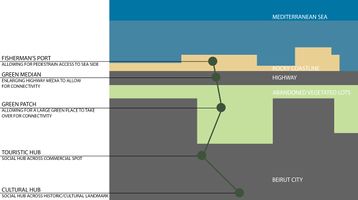 Transect: Cultural+Ecological
 -
 Transect Zoom in on intervention


C.3 From Theory of Change to Implementation
- The main partnerships that should be built are mainly between the government and the stakeholders of that area with the locals and NGOs that aim to protect this landscape. The governance model that is required is the Carver Board Governance model that focuses on the ends of the organization's purpose, in this case being the focus is the coastline. This model works for nonprofit and for-profit organizations. The Carver Model places its focus on the “ends” of the organization’s purpose. The organization actively works towards what it needs to achieve or what it needs to do.
- The vision will be implemented by establishing strict guidelines and laws that should never be broken in order to protect the landscape. After establishing what areas need to be reclaimed back for public use, the project can commence. The assets highlighted as hatched in the figure below show how much lands are public and are let go or are illegally privatized.
-
 Carver Board Governance Model: Model places its focus on the “ends” of the organization’s purpose
 -
 Assets to start building on: hatched areas


C.4 References
- give a full list of the references you have used for this section
- https://www.jadaliyya.com/Details/30708
- https://www.boardeffect.com/blog/board-governance-models-a-comprehensive-list/
D. Process Reflection
Analyzing Landscape Change and Urban Sprawl in a Mediterranean Coastal Landscape: A Case Study from Izmir, Turkey Very similar case to Beirut urban sprawl, the coastline was later interjected with settlements This study interprets the temporal and spatial landscape changes that occurred can be projected to develop more-sustainable urban planning strategies for the future of the area They evaluated the land-use and the change of areas and which major land-uses were affected due to the urbanization period
Landscape trajectories: sea level rise and future landscape New Zealand region Assessment was based on the areas at risk of flooding, extreme weather conditions, climate change will create more extreme events. Beirut still hasn’t suffered from major flooding events across coastline but mainly due to the weak infrastructure ad extreme rain conditions. Understanding the forms, practices and relationships of past landscapes help us explore possible trajectories, (1) thinking of ways to regenerate the lost ecological habitats such as lagoons and wetlands due to urbanization, (2) thinking of the current values of the people and their relationships in the landscape, (3) what people are expecting/want from the landscape in the future Major theme was to focus on interconnections between the past, present and future landscapes
Early warning signals for landscape connectivity and resilient conservation solutions a holistic resilience‐based framework to identify the early warning points of climate‐gradient landscape connectivity; the results offer the first map capable of providing information about landscape connectivity in the coastal provinces of mainland China The magnitude of spatial interactions between human activities and natural habitats is an essential determinant of anthropogenic threats to landscape connectivity, which is highly evident in our case where the human settlements create major disconnections among ecological patches