Case Study B: Pelguranna
>>>back to working groups overview
| Area | Pelguranna | |
| Place | Tallinn | |
| Country | Estonia | |
| Topics | please enter the main coast-related topics here | |
| Author(s) | Petar Jurički, Ferhat Türkoğlu, Sandra Solba, Jelena Sabovljević, Elena-Mihaela Ciobanu, Manon Bourdin, Winkin Alexandre, Beatrice Andreea Apetrei | |

| ||
Rationale
- Stroomi beach has a great value because it is located close to the city center and because of residents’ vicinity to the coast. The area has a lot of potential for tourism development, but the lack of connection to the other parts of Tallinn affects it.
Location and scope
You can edit this map with the map editor
{{#display_map:
A Landscape System Analysis
A.1 Landscape layers and their system context
Geomorphology, landscape units and coastal typology
- Description of evolution, status quo and driving forces, is the coastal typology changing? Why is that? (approx 200 signs)
Pelguranna consist of fine sand and silt deposits (Stroomi) with a sandy foreshore which is included in the most relevant landscape units which are sea, coast, park and urban area. Major drivers in the area are geomorphological processes (waves, storms, tides, ice and erosions) and urbanisation. Taking everything into account it is evident that the coastal typology has potential to change in the future mostly depending upon the dominant drivers that were mentioned before with addition of sea level rise. This change will mostly be effected by the washing out of the fine sediment (sand) from the shore and the sea level rise thus making the beach narrower in the future with the sea moving inland.
- add 1-2 graphical representations to the image gallery, you can add more if you like

Classification of natural perched beaches using a geomorphic approach, source: Shari L Gallop, January 2011

Operational landscape units for SF Bay: using nature's jurisdictions to plan for sea level rise, source: San Francisco Estuary Institute, 2019

Seven types of coastlines, source: geography.name

Scheme of the glacial uplift process, source: : https://spotlight.unavco.org/station-pages/chur/chur.html

View on the Stroomi beach, source: http://www.arcovara.ee/et/blogi/220-arco-vara/106798-paerl-merimetsa-ja-stroomi-ranna-vahel


Land use
- settlements, infrastructure, agriculture, resource extraction, natural areas, energy production...
- description of evolution, status quo and driving forces, is the land use likely to change? Why is that? (approx 200 signs)
- add 1-2 graphical representations to the image gallery, you can add more if you like
Up to the 19th century, or the beginning of industrialization, Pelguranna was known as a wasteland, a place without a proper function, other than having vegetable gardens, owned by people from neighboring districts. In 1870, the railway found its place in Tallinn and brought with it the fast development of industry, as can be seen in Kopli district, which became the "heart of Tallinn's industry". As a result, many companies started building in the zone. Many workers from those fabrics/companies built their homes in Pelguranna, as it was one of the undeveloped, or better said, unoccupied parts of Tallinn's territory. These were simple, one story houses. During the war period, the number of residential units started growing in numbers and scale, especially in the 20's with 2 storey buildings. As the industrial places started growing, so did the number of people working for them. Thus, Pelguranna became a well occupied district with a high number of flats, residential units. Today, most of the buildings are in a bad condition and require an upgrade. The district is not lacking in natural areas. Not only is it close to Stroomi Beach, which is a major part of Tallinn's shoreline, but also has a lot of greenery surrounding the residential units.
The land is likely to be changed in the future. With the modernization of the residential units and the proper care of Stroomi beach, Pelguranna could become a touristic place, or a better recreational spot. Pelguranna's natural areas provide an opportunity for the development of ecosystems in a constantly growing city. This would provide a series of advantages, such as as spiritual, recreational, and cultural benefits, and supporting services, such as nutrient cycling, that maintain the conditions for life on Earth.

CORINE Land Cover, Change from 1990 to 2018

Urban Atlas Land Use Map of Northern Tallinn

Recreationally Valuable Land Units and Buffer Zones Mapped in the Green Layer

Recreation Opportunities in Northern Tallinn

Mapped Service Providing Units With the Necessity for Green Infrastructure Connections


Green and blue infrastructure
- Green infrastructures:
1) Stroomi Forest
2) Kopli Cemetery park
3) Green belt (Puhangu street)
- Blue infrastructure:
4) Kopli bay
5) Stroomi Beach
- In the Pelguranna district zone, the major potential elements of green infrastructures are mostly implemented out of the district’s limits. This found explanation because of the hugeness of these infrastructures like the Stroomi forest (135ha) and the Kopli Cemetery park (99ha). Due to the proximity of these two parks with housing district’s part, the need of park inside of the district is not primordial. The Kopli Cemetery park has a particular story bringing cultural attachment to the inhabitants of Pelguranna. Established in 1774, the park was at first use a cemetery welcoming Tallin’s citizens’s graves until 1944. Due to his strategic position, the cemetery has been transformed into a military base during the WWII and finally be reused as a park from 1950 until now. The blue infrastructure elements are represented by the Kopli Bay giving the strong landscape identity to the district and the Stroomi Beach situated next to it. These elements take his importance by being the busiest attraction of Pelguranna because of its touristic recognition.
- The only element being menaced by authorities is the Stroomi forest. Its status is making debates between the citizens and the urban planners planning the future of the district. Since 1990 and 2015 the actors are in a conflict situation where the citizens are defending the natural preservation of the forest and the urban planners trying to build roads connecting the neighbouring districts and implementing new housing areas.

Green and blue infrastructures map

Stroomi Forest

Kopli Cemetery park

Green lane (Puhangu street)

Kopli Bay

Stroomi Beach


.jpg)


Actors and stakeholders
- Pelguranna is a residential area. Its lands belongs to the public administration of Pöhja-Tallinn municipality. They control land change according with citizen association and universities then agreed or refused by the municipality of Tallinn, who comes directly to Taavi Aas, president of the center parti, in constant debate with the gouvernment .
- The actual ambition of Tallinn for its development is to improve the connection between the historic center and the coast. Because of the last russian dependance, the idea is to look at the nordic city's coasts (oslo, stockholm, helsinki), and find a new estonian image. The access from the see has to be restored. In 2020, new roads, bicycle pathway and tramwway are provide for Pelguranna. In this case, projects are imposed to the district municipality and its residents. Visitors and especially tourists who occupe the littoral and the Stroomi beach influence the economy of the city and could make of Pelguranna an interesting area of development. Inhabitants, belonging to the working class and primarily russian could be affected by this approach and could loose their access to the sea.

Powermap of Pelguranna

Indicator of social class in Tallinn https://blog.stat.ee/tag/degusteerimine/
Indicator of tourism in Tallinn https://blog.stat.ee/tag/degusteerimine/

Development plan of Tallinn for 2020

Development plan of the streets infrastructures for 2020


Sacred spaces and heritage
- Which places/elements hold cultural value and to whom?
- You may add a map and some images, please also explain in your caption why these elements are valuable
Although there aren’t any enlisted monuments inside our studied area, Pelguranna still shares its part of history and it is full of various built heritage. Most of the built heritage in our area is in good shape, well preserved but every now and then you might come across buildings which are in bad shape. An idea for protecting and refurbishing them would be by raising awareness of what Pelguranna has to offer. A good way for doing that might be by including them in a sight-seeing/bicycle route connected with the other important or enlisted monuments. The Waldorf School in Pelguranna is very important - it has cultural, historical and architectural value and it is a good example of Soviet architecture with classic influences which is specific for the 30-50ies. Besides its well-preserved details, the school also stands out with its curriculum that has many extra activities to offer to its students. The monuments which can be found in proximity to our area’s proximity belong to the Baltic Cotton factory which dates back to the early 1900 and its Consumer Association Building that dates back to 1930. The Railway lines also share historic value because it was the main mean of export. Close to the Railway, there are enlisted houses that date back to 1929.

Mapping of enlisted monuments and heritage sites in Tallinn. source: register.muinas.ee

Zoom in of enlisted monuments and heritage sites with a focus on Pelguranna

Which are the places that people visit? Where do they spend their free time? Where do they study - mapping of valuable elements in/out city

Mapping of architectural styles in our case study


Visual appearance and landscape narrative
- Which elements are essential for the landscape character?
Long shallow sandy beach hidden behind a thick layer of diverse Soviet time block houses from almost all decades of Soviet occupation. The beach is partly covered with pine forest and grassy areas.
- Stroomi beach has been an inspiration for centuries. One of the first visualizations of this landscape was created in 1688 by Samuel Waxelberg. It is a map depicting the region mostly in grassland. One of the earliest paintings of Stroomi beach were done by the Estonian artist Paul Burman. Both of his paintings were created in the second half of the 1920s – beginning of the 1930s, showing the landscape of the beach and Stroomi pine forest. In 1936 an illustration from the newspaper shows specific kind of lifestyle typical for the beach. The landscape still represents an inspiration for artists nowadays. In 2015 Estonian artist Kaspar Tamsalu painted the view from the window to the sea, showing the liveliness of the landscape.
- Both Pelguranna and Stroomi beach have often been mentioned in old newspaper from the second half of 1930s. These articles mainly describe progress and rebirth of Pelguranna and new plans for the development of the area. Additionally, the construction of “good-looking buildings” and modern life on the beach captures identity of the area at that time. Pelguranna also represents an inspiration for poets. The poem “My Tallinn” written by Kirke in 2011 depicts particular atmosphere of the area. In 2012 the well known Estonian contemporary poet Contra wrote “Facebook-born poem”.

Samuel Waxelberg, Merimetsa wood (1688)

Paul Burman, Winter landscape, Stroom Forest (1920-1930)

Paul Burman, Motive of Stroomi Beach (1920-1930)

Kaspar Tamsalu, Untitled (2015)

Unknown, Stroomi's Own Culture (1936)

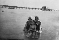
Marines Shooting at Stroomi (1930-1932)

Navy Shooting at Stroomi Beach (1933)

Waves in Pelguranna (1937)

Toompea as Seen from Pelguranna (1937)

The Trace of the Foundation of the Pelguranna (Stroomi) Café Burned in 1944
Stroomi Beach

High Voltage Lines in Pelguranna (1962)
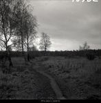
Path in Pelguranna (1975)

Stroomi Beach
.png)
.jpg)
.jpg)
.JPG)
.jpg)


_Caf%C3%A9_Burned_in_1944.jpg)


A.2 Summary of you landscape system analysis and your development Targets
- You can summarize your findings with an DPSI(R) Model or a Spider Diagram
- Link back to the Sustainable Development Goals: Which goals are at risk?
Point 3: Good health and well-being, Point 8: Decent work and economic growth, Point 11: Sustainable cities and communities, Point 13: Climate action, Point 15: Life on land
- What is your hypothesis for this landscape?
The current situation of Pelguranna shows a district with almost no vicinity with its location near the coastline. Buildings with four to six floors were built and used by the majority of russian rooted citizens. The green park appears to be a border between housing and leisure at the shoreline. The shore itself is mainly used by its surroundings. The hypothesis is based on two aspects. The natural process and man-made interactions. The shoreline will shrink and will narrow through the natural migration of sediments. The population on the other hand will grow and urban sprawl will be the result. Green open space areas which surround the buildings will get less and density of housing will rise.
The main problem that occurs in the area is the lack of connection of Pelguranna and Stroomi beach with the other parts of Tallinn. Hence, the development of a net of trails both bike trails and for pedestrians, will allow users to experience landscape from different perspectives and speeds. By developing the system of trails through the neighborhood, the diversity of Soviet time house block will be emphasized. Finally, as the beach is located very close to the residential area, the tourism should be developed, but in a way that it doesn’t affect everyday life of residents.
- Visualise your hypothesis with one graphic/pict
- Are there any existing initiatives taking action in this landscape? Do you have a critical perspective on that?
- Add text and visuals

DPSIR method of our system analysis


The current situation of Pelguranna in our hypothesis

The scenario of Pelguranna in our hypothesis

Proposals for the future development of Pelguranna and its shoreline


Overlapped Recreational and Ecological Layer

Recreational Layer - Mapping of Potential Areas for New Recreational Opportunities and Areas in Necessity for Better Recreational Connections


A.3 Theory reflection
- Reflect on at least three international policy documents in relation to their local landscape case
- choose one international, one European and one national document
- You can choose references from our reading list
- Scope: 250 words
International policy document
UN-HABITAT introduce Guiding Principles for City Climate Action Planning to help planners thinking future for cities. By reviewing different steps, from organization and participation to strategy and action, they establish guiding principles. First, the idea must be ambitious, inclusive with all planners and fair for local inhabitants. Next, it needs to be adapted with all the restrictions of each part in order to be comprehensive and integrated within all sectors of the city, then relevant and deliver local benefits, finally actionable and at a cost-effective. Thus, the result should be evidence-based, reflecting scientific knowledge about buildings, water, energy, transport, wastes, and good health. According to it, the planning process needs to evolve with a strategy of communication plans, inventories, scenario analysis and assessment of responsibilities. The objective is to become a compromise between future needs of the population, new reglementations for the climate, environment constraints and efficient actions that increase flexibility for the geographical area.
Pelguranna is mostly a residential area but generous in green area and subject of development. This document is relevant because it raises the participation of all the stakeholders. Projects are existent if they are understood by all communities. Therefore, planners should support local use from the inhabitants of Pelguranna, improve the access to his surroundings, develop the facilities of the green areas and upgrade building consommation. People should be the plan because they are living it.
European policy document
In 2000, Florence was the host of the European Landscape Convention which recognized the importance of landscape, defining it as a part of land perceived by both local people and visitors and which evolves in time as a result of natural forces and human actions. The purpose of the convention was to promote protection, planning, and management of European landscapes and to establish a form of co-operation regarding landscape issues. The landscape, be it degraded or outstanding, small or mundane, importance should be equally recognized. Another key aspect of the convention is that it assigns an active role to the public regarding their perception and evaluation of landscape. The public should be directly involved, not just specialists, therefore, the landscape quality objectives are set by aspirations of the public and landscape features, surroundings which are furthermore formulated by competent authorities. In our case, Pelguranna has all the types of landscapes whose importance was recognized through this convention - daily landscape, outstanding landscape (the beach, the green belt separating the residential area) and decayed.
National policy document
Based on Tallinn Environmental Strategy to 2030 the capital of Estonia is presently considered an attractive destination for foreigners and a possible forerunner of the competitive economy concerning an innovative green and safe urban environment. The development of integral and optimal vegetation is one of the objectives. Vegetation and greenery must be preserved and green areas duly maintained. The green systems in the city center are integral and must be connected by green corridors. The population must have easy access to green areas, so they must be sufficiently. Parks, green areas, forests and other natural areas situated within the limits of the are appreciated irrespective of their form of ownership as the factors ensuring natural diversity and ecological balance and extension of building activities to these areas will be restricted.
A.4 References
- 1. Discomap.eea.europa.eu. (2019). [online] Available at: http://discomap.eea.europa.eu/map/Data/Milieu/OURCOAST_323_EE/OURCOAST_323_EE_Doc_TallinnEurosionCS.pdf [Accessed 27 Mar. 2019].
- 2. A summary of Geomorphology.(2019) [online] Available at:
https://www.researchgate.net/figure/Classification-of-natural-perched-beaches-using-a-geomorphic-approach_fig4_313393436 [Accessed 28 Mar. 2019]
- 3. Landscape Units. (2019) [online] Available at:
https://www.sfei.org/projects/OLUs [Accessed 28 Mar. 2019]
- 4. Types of Coastlines. (2019) [online] Available at:
http://geography.name/types-of-coastlines. [Accessed 28 Mar. 2019]
- 5. Anon, (2019). [online] Available at:
https://spotlight.unavco.org/station-pages/chur/chur.html [Accessed 1 Apr. 2019].
- 6. Arco Vara. (2019). Pärl Merimetsa ja Stroomi ranna vahel. [online] Available at:
http://www.arcovara.ee/et/blogi/220-arco-vara/106798-paerl-merimetsa-ja-stroomi-ranna-vahel [Accessed 1 Apr. 2019].
- 7. Dautancourt V. (2016). [online] Available at:
http://www.theses.fr/2016PA080004 [Accessed 1 Apr. 2019]
- 8. Delfi, (2013). Mihkel Karu: Pelguranna. Arhitektuuriajaloolase pilguga. [online] Available at:
https://www.delfi.ee/archive/mihkel-karu-pelguranna-arhitektuuriajaloolase-pilguga?id=66411948&fbclid=IwAR1IruLsETLYk2k-hF5f0Cm8EKPxBTgPXwEPM0l5fuesffUfaszqpQXXGRs [Accessed 1 Apr. 2019].
- 9. Digar. Uus Eesti, nr. 35, 5 veebruar 1939. [online] Available at:
https://dea.digar.ee/cgi-bin/dea?a=d&d=uuseesti19390205.2.23 [Accessed 1 Apr. 2019].
- 10. Digar. Päewaleht, nr. 221, 12 august 1935. [online] Available at:
https://dea.digar.ee/cgi-bin/dea?a=d&d=paevalehtew19350812.2.36 [Accessed 1 Apr. 2019].
- 11. Digar. Uudisleht, Number 108, 14 July 1936. [online] Available at:
https://dea.digar.ee/cgi-bin/dea?a=d&d=uudisleht19360714.1.7&srpos=5&e=------193-en-25--1--txt-txIN%7ctxTI%7ctxAU%7ctxTA-pelguranna+stroomi------------ [Accessed 1 Apr. 2019].
- 12. Tallinn, (2014). Stroomi Beach Park. [online] Available at:
https://www.tallinn.ee/eng/Stroomi-Beach-Park [Accessed 1 Apr. 2019].
- 13. Blogspot, (2012). Contra -Urvaste süda.[online] Available at:
https://konnulacontra.blogspot.com/2012/04/facebookis-sundinud-luule.html?fbclid=IwAR2Vs3GgN5q2K5HgjFh_TPbbP9TO7o_7rRZZxnD3dXNU-sLOT8pZD16B-UU [Accessed 1 Apr. 2019].
- 14. Blogspot, (2011). Kirke luuletus. [online] Available at:
https://leaheier1.blogspot.com/2011/11/kireke-luuletus.html?fbclid=IwAR07YjhX4sOHRLysj2bPNKwr3pem-DPxjrmRjq52uj6OyIP-EyDY32uLMO0 [Accessed 1 Apr. 2019].
- 15. Visit Estonia, (2018). [online] Available at:
https://www.visitestonia.com/en/stroomi-beach [Accessed 5 Apr. 2019].
- 16. Rahvusarhiivi fotoinfosüsteem, (2019). Kõrgepingeliini postid ja võtted Pelgurannas. [online] Available at:
http://www.ra.ee/fotis/index.php/et/photo/view?id=566485&_xr=5ca68023a339a [Accessed 5 Apr. 2019].
- 17. Rahvusarhiivi fotoinfosüsteem, (2019). Teerada Pelguranna aiamaal. [online] Available at:
http://www.ra.ee/fotis/index.php/et/photo/view?id=610201&_xr=5ca680b578773 [Accessed 5 Apr. 2019].
- 18. Rahvusarhiivi fotoinfosüsteem, (2019). Lained Pelgurannas. [online] Available at:
http://www.ra.ee/fotis/index.php/et/photo/view?id=610624&_xr=5ca681074cd88 [Accessed 5 Apr. 2019].
- 19. Rahvusarhiivi fotoinfosüsteem, (2019). Toompea Pelgurannast vaadatuna. [online] Available at:
http://www.ra.ee/fotis/index.php/et/photo/view?id=610625&_xr=5ca681165f2d8 [Accessed 5 Apr. 2019].
- 20. Ajapaik. Mereväelased laskeharjutustel Stroomi rannas (1930 – 1932). [online] Available at:
https://ajapaik.ee/photo/120578/merevaelased-laskeharjutustel-stroomi-rannas/ [Accessed 5 Apr. 2019].
- 21. Ajapaik. Stroomi rand. [online] Available at:
https://ajapaik.ee/photo/120577/stroomi-rand/ [Accessed 5 Apr. 2019].
- 22. Ajapaik. 1944. aastal põlenud Pelguranna (Stroomi) kohviku vundamendi jälg. [online] Available at:
https://ajapaik.ee/photo/117973/1944-aastal-polenud-pelguranna-stroomi-kohviku/ [Accessed 5 Apr. 2019].
- 23. Ajapaik. Mereväe õppekompanii I kompanii 1. rühm laskeõppustel Stroomi rannas (1933). [online] Available at:
https://ajapaik.ee/photo/117964/merevae-oppekompanii-i-kompanii-1-ruhm/ [Accessed 5 Apr. 2019].
- 24. Urban atlas 2012. [online] Available at:
https://land.copernicus.eu/local/urban-atlas/urban-atlas-2012 [Accessed 5 Apr. 2019].
- 25. Stroomi mets on Tallinna pärl. [online] Available at:
http://pelgulinnaselts.ee/stroomi-metsa-saaga/ [Accessed 5 Apr. 2019].
Phase B: Landscape Evaluation and Assessment
In our previous landscape system analysis, our hypothesis was based on two major aspects which define the studied area - the natural landscape and the man-made - one which might become narrower and the other grow, resulting in urban sprawl. Therefore the goals we have set for assessing the landscape were: finding a sustainable way of controlling urban development, better and eco-friendly mobility, studying possible measures of sea level rise prevention, finding the un-used and abandoned places, finding possible solutions for eco-tourism, finding hotspots, multi-directional economical growth. Once we had these goals set, we mapped the following: historical growth, infrastructure, topography, gravity plan, land-use, typology, waterscape.
B.2 Mapping
- As defined by your assessment strategy you conduct the mapping and present your findings here
- As a minimum, at least three different themes need to be mapped, you may choose more if needed
Mobility assesment
The mobility of Pelguranna is in a development process working to be established and finished for 2020.
Four great guidelines are being implemented to facilitate the soft mobility and easy public transport access.
Public transports are developed mainly with bus lines occupying the central and southern parts of the district. The tramway is quite underdeveloped. The need of more public transport is not an issue because of the sharpness of the territory. The bus stops provide a good distribution along the territory.
The road system is also in development and looks like it is menacing the territory and its landscape by planning to construct new principal roads around some green spaces like the Stroomi Forest and a tunnel to anticipate the growing traffic of vehicles.
Opposite to the need of new roads and access, the territory is also evolving in its global comprehension. The city understood that the citizens needed a certain security by walking or cycling around the roads and the new ones implemented in the future. The networks of cycle tracks had been completely reviewed to optimize the soft mobility experience for the citizens. The inhabitants of Pelguranna are going to take advantage of cycles tracks around the limits of the district in addition of one cutting in the middle of it horizontally.

Mobility system

New mobility connexions


Sea level rise/topography
Relatively flat topography with sea level rise and its currents are the most relevant factors of shore sand washing. Sea level rise is a great threat to the natural heritage of the beach and the coast, although its a long process it is still a threat. As seen on the map the sea will cover the whole beach in Pelguranna leaving nothing behind. Sea level rise is also a threat to the settlements because with sand washing away and the protective dunes disappearing it is safe to say that the water will become a great threat in the future.

Sea level rise/topography

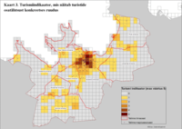
Tourism
The tourism in Pelguranna is mainly focused on the sightseeing of the natural heritage and relaxation near Stroomi Beach. The neighborhood is a residential one, thus it may offer personal tourism, from visiting acquaintances to finding accommodation near the city center. Plus, there a few buildings in the vicinity of our studied area which hold a cultural value. We believe in the conservation of the natural area (the parks and the beach) so it might not be altered in case of great numbers of tourists. Moreover, the development of a good pedestrian accessibility from more visited parts of Tallinn to Pelguranna would be a great way to promote the neighborhood as a tourist friendly one.

Tourism

Gravity Points
The citizens of Tallinn are spending their free time usually in downtown and the oldtown area. In case of Pelguranna, the district has no attractivity in leisure and recreation, despite being next to the coast. The shoreline in north east of Tallinn on the other side is gladly used.
The same situation is given in spending time at home and at work. The mainly territory is again the oldtown and downtown area, but also the south western part of Tallinn. Many industrial companies play and important role in the southwest of the city. Pelguranna itself is not seen as a place for sociocultural well-being.

Free time anchor points, source: Daily rhythms of suburban commuters’ movements in the Tallinn metropolitan area: Case study with mobile positioning data, (2010)

Home and work anchor points, source: Daily rhythms of suburban commuters’ movements in the Tallinn metropolitan area: Case study with mobile positioning data, (2010)


Economical Growth
The city of Tallinn is growing on size and population continuously, whereas the community of other states of Estonia are decreasing, especially in the south and the east. The reason is an offer of perspective and work. The payment in the capitol is better than in the country side. This is also one of the reasons why the dempographic change in Tallinn is immense. The percentage of old people in the city is the lowest in whole Estonia.

Population change in Estonia, source: Tallinn Area and its Regional Hinterland - case study report, (2013)

B.3 Problem definition and priority setting
Risks
- Mobility: over-exploitation of the existing streets, unsustainable higher-density traffic and other means of mobility.
- Urban sprawl: It is threatening the green spaces, increasing the amount of building sites and threatening of the optimal structural density.
- Water-level rise: with addition to the beach sand wash away by the sea there is a risk of the Stroomi beach disappearance
- Tourism: increased littering of the City and Stroomi beach, trash pollution
- Economical growth: aging of the citizens with decreased economical growth
Potentials
- Mobility: development of sustainable, eco-friendly and regulated means of mobility
- Urban sprawl: Migration of new families into the district adn with controlling of the urban sprawl it the mentioned risks can be avoided or lessened
- Water-level rise: regulation of the water and sand wash away could extend the beach lifetime and its use by the citizens and tourists alike.
- Tourism: potentials for eco, heritage and leisure tourism with an increase in economical growth
- Gravitational points: potential for higher variety of investments and paths for development
- Economical growth: potential for new/young families and people to start their business and enhance the economical growth
Priorities
Priority is to find a way to protect and enhance existing ecosystem services while developing the community with sustainable mobility and economic growth
Balance: Pelguranna could be an area focused on youth, development of startup companies, sustainable mobility (bicycle trails etc.) with a certain amount of leisure activities and tourism (on the beach and on green spaces around the settlements).

Synthesis of the analysis

Risks and Potentials, source: Google Maps


B.4 Theory reflection
- Please reflect the assessment and evaluation methods used based on at least three readings
- Did you encounter limitations'
- 200 words test contribution
Mainstreaming ecosystem services into EU policy
The processing in implementing the mainstreaming ecosystem services into the EU policies is such a big challenging goal to reach. Aligning the objectives of the EU water policy and the EU common agricultural policy with the target of the Europe 2020 strategy is a great engagement in terms of communication and organization. With this kind of reflections, the natural ecosystem will be considered with the status of source of economic development. This will mean that visiting a natural protected area will demand a cost for the population. This source of money will be used for maintenance and provide a certain respect of the area. This indicator will also process the goal to make the citizens more aware about the importance of the area they are using. This is a great process but maybe a bit idealistic. In the economical system we are living in, some undeveloped cities can be situated in a certain lack of economical richness and can probably can transform certain kind of situation into worse. To counter this kind of dramatic situation, the EU authorities need to pay attention to the externalities of project scales so before making any shift, some studies must be made case by case to articulate the protected areas in the economic systems.
B.5 References
- 1. Daily rhythms of suburban commuters’ movements in the Tallinn metropolitan area: Case study with mobile positioning data, (2010). Rein Ahas, Anto Aasaa, Siiri Silma, Margus Tirub. [online] Available at:
https://www.sciencedirect.com/science/article/pii/S0968090X09000400#fig1 [Accessed 3. May 2019].
- 2. Tallinn Area and its Regional Hinterland - case study report, (2013). Imre Mürk [online] Available at:
http://www.grincoh.eu/working-papers?get=6a79ecbcdb853166b6ecfce13246460a [Accessed 3. May 2019].
Phase C – Strategy and Master Plan
C.1 Goal Setting
- Define strategic planning objectives based on the evaluation findings
- Link back to your original targets from section one and the Development Goals
- 150 words text contribution
C.2 Spatial Strategy and Transect
- translate your strategic goals into a vision
- develop a spatial translation of your vision
- exemplify your vision in the form of a transect with concrete interventions
- add map(s) and visualizations
- Your case spatial translaton vision.jpg
add caption here
- Your case transect.jpg
add caption here
- Your case transect detail1.jpg
add caption here
- Your case transect detail2.jpg
add caption here
C.3 From Theory of Change to Implementation
- For implementing your vision: Which partnerships are needed? Which governance model is required?
- Who needs to act and how? Draw and explain a change/process model/timeline
- Which resources are needed? On which assets can you build?
- add 150 words text and visuals
- Your case spatial your governance model.jpg
add caption here
- Your case spatial your process model.jpg
add caption here
C.4 References
- give a full list of the references you have used for this section
D. Process Reflection
- Reflect in your intercultural and interdisciplinary team on the outcomes of your study
- Which limitations were you facing?
- What have you learnt from each other?
- What would you do differently next time?
- You can also use diagrams/visuals
- 250 words text