Case Study C: Averno
>>>back to working groups overview
| Area | Averno | |
| Place | Pozzuoli | |
| Country | Italy | |
| Topics | Volcanos, sensitive landscape | |
| Author(s) | Alexandra Lungu, Asif Adnan, Bianca Ivascu, Bruna Spagnol, Dario Esposito, Ema Plopeanu, Helene-Terese Jürgenson, Virginia Cuneo | |

| ||
Rationale
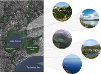
When looking rapidly to this area, one can notice where mystery of the location is adapting to reality, creating an extraordinary landscape. Composed of the beach, mountains, volcanic lakes and a collection of cultural heritage. Going more in depth with landscape analysis, it is realized that the complexity of the geomorphology is a challenge for the human development, due to small free areas available. This pressure caused by the human needs risks the unique vegetation in the volcanic areas, so important for the maintenance of the local ecosystem. This disturbance would affect dramatically the existing blue and green connections.
The tectonic and volcanic activities that shaped Italy are huge threats as well, once it is not possible to control them. With technology, it is possible to prevent catastrophes and human losses, but material damages are always in stake. Matters such evacuation routes and procedures, shelter, water and food in cases of natural disasters are especially important in this location.
Regarding our abilities as architects and landscape architects, it is our priority to raise awareness about the relevance of the locals as well as keep in mind the quality of life of the inhabitants, their connection with the environment and sustainability of new developments.
Location and scope
A Landscape System Analysis
A.1 Landscape layers and their system context
Geomorphology, landscape units and coastal typology
The formation of Italy as we know is the result of a series of complex sismic movements, starting from the collision between the African and European tectonic plaques. The sequence of collisions created the long chain of montains that crosses the country from south to north, the Alpenines. Smaller geografical accidents happened due to the phenomena, which, combined with the volcanic activities, led to the nowadays morphology.
In Pozzuoli, it is not different: lakes, shores and reefs tell us the evolution of the landscape. Today, both sismic and volcanic activities remain quiet, but not long ago, in the 1980's, Pozzuoli had to move around 50m ahead from its original location due to a rapid rising of the earth surface. Combined with the stress caused by populational growth, the town could a major change on its landscapes
-
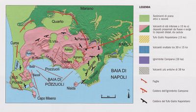 Geomorphology Pozzuoli. Source: http://ncpcstasia.weebly.com/il-rischio-vulcanico.html
 -
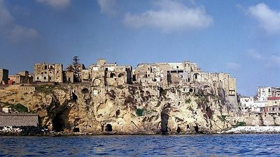 Coastal volcanic rocks. Source: https://www.repubblica.it/viaggi/2015/12/04/news/scoprire_campi_flegrei_napoli_campania-128801959/
 -
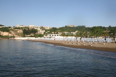 Low coast with volcanic rocks on the background. Source: https://lidonapoli.it


Land use
The study area is mainly characterized by residential, agricultural and touristic activities.
The agriculture consists mainly of fishing, pomiculture, viticulture and greenhouses. Those are divided in different zones: fish farming on the coast and vineyards, orchards and greenhouses towards the mainland. Tourism is a present and visible activity on the coast and close to the Lake Averno and Lake Lucrino and to the natural heritage elements.
Regarding settlements, the configuration of the land (coast, volcanic cones and lakes) limits the expansion of the built area and the Averno Zone is in need of housing facilities. If the housing activities expand, the farmlands which are important to the local economy, will be endangered.
The main infrastructure consists of three main railways: the Cumana Railway, The Circumflegrea railway which is a commuter railway line that connects Naples city center with the northern Phlegraean Fields, a suburban area located west of the city and line 2 which is a commuter rail service operated by Trenitalia in the city of Naples, Italy that connects 12 stations. Also in the study area we can find the A56 highway - which cuts Pozzuoli in half(the administrative area and the colective housing on one side,and the Hospital and the individual housing on the other side of Pozzuoli). The local road sistem is permeable enough, but the public transportation that connects the Averno area with the rest of the region is made possible only by train, which is slow, resulting in a bad connection especially with Napoli.
Resource extraction is based on geothermally heated groundwater which are appealing for tourists. The Averno study area has many recreation centers based on thermal waters.
A large percentage of the study zone consists of two volcanic lakes(Averno and Lucrino) and the Regional Park of Campi Flegrei(on the Monte Nuovo volcano). The coast is highly urbanized with the presence of the railway and the touristic activities. Although he railway conects the study area with the City of Naples, on a local perspective, it acts like a physical and visual barrier between the coast and the mainland.
Energy production consists, at the scale of Campania region, mainly in electricity production from wind power which increased over tenfold from 2002 to 2015.
The study area which is a part of Campania region has many diverse activities from agriculture to housing to tourism, but without a coherent strategy the area will remain non-pedestrian friendly and with poor interconnection in a regional system regarding the public transport.
-
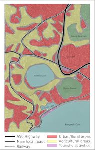 Averno Land Use

Green/blue infrastructure
The study area has strong elements of both blue and green infrastructure.
The blue elements are represented by the lakes of Averno and Lucrino, the seafront of Pozzuoli and Lucrino, the underwater archaeological reserve of Lucrino, and the Tyrrhenian Sea. Also, the entire area benefits from the geothermally heated groundwater.
The green elements are represented by the Monte Nuovo volcano (where the Regional Park of Campi Flegrei is located) a small part of the Monte Gauro, the crater of Averno, and the Lucrino Coast.
Although both green and blue elements have a strong presence in the territory, and are of high importance in the future economic development of the coast, they are undervalued (on a touristic perspective) because of the rather shallow links between them. Another issue which regards the Phlegrean coast, is represented by the level of pollution of the sea, which impacts on an ecological perspective the marine biodiversity, and on an economic perspective, the level of attractiveness of the area for tourists. (for as long as bathing on the coast is not allowed because of the sea pollution).
The proactive actions towards improving the green-blue infrastructure of the Averno region will result in an increase in ecological awareness, protection of the marine biodiversity, and in the development of the local economy.
-
 Green & Blue Infrastructure - Averno

Actors and stakeholders
Thanks to the stakeholders' analysis it is possible to outline the actors of the study area and prioritize them by power and interest. The area is part of the Municipality of Pozzuoli, one of the 92 comuni belonging to the Metropolitan City of Naples and it is the main city of the Phlegrean fields. The leading institutional actors involved are the Basin Authority, the province of Naples (Metropolitan City of Naples), Campania region and, of course, the Municipality that is responsible for more practical decisions.
In particular, the Basin Authority is an institution that operates at a national, interregional and regional level, on the catchment areas and deals with the defense of the soil and subsoil and the rehabilitation of water. The water catchment areas of the Phlegraean fields are managed by the "Regional north-western Campania Basin Authority" that has strong power in this area. The Campania Region has had a high interest in the Phlegraean area in recent years. This can be explained by several reasons, above all the proximity to the Bagnoli area, of which it should constitute the natural continuation in view of the conversion of the entire area into an area dedicated to tourism and entertainment.
Other actors involved, but with a low level of power, are the citizens that actively participate in the social and economic life of the study area. To the business owners belong a huge piece of stakeholders with a pretty strong interest in the area that can not be excluded (bars, restaurants, dog park, sports activities, spa, diving center, tourist accommodations).
The tourists could be considered as actors in this system too: they have not a particular power of decision in the development of Pozzuoli Municipality, even if they are not pretty much affected by the urban changes. Thanks to the presence of several farmhouses and agricultural cooperatives the area attracts every year a quite huge number of tourists that want to experience a rural life.
Also, the non-profit organizations have a strong social impact on the territory.
A relevant role is played by “Percorsi Cumani”, a community of people with a common priority: create a network of cycle paths extending throughout the Campi Flegrei area from Nisida to Miseno. The “Percorsi Cumani” project aims to present to the public administrators in the Naples Metropolitan area an alternative transport, more sustainable. The study area is strongly involved in this project, in particular regarding the area near the Averno lake that could be connected to Cuma thanks to the restoration of the viability of the Cocceio Cave, the historic passage carved by the Romans that connected the Averno lake to Cuma.
-
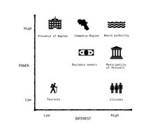 Power Map of Pozzuoli's Stakeholders
 -
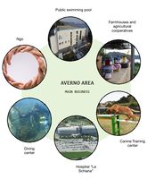 Diagram showing the main business of the study area. Except for the farmhouses that are visited every year by Italian and foreign tourists, the other business are more intended for who live nearby.
 -


Sacred spaces and heritage
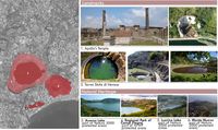
The study area consists of two very important landmarks: Apollo’s Temple and Terme Stufe di Nerone and also really important natural heritage elements: Lake Averno, Lake Lucrino, the Regional Park of Campi Flegrei and Monte Nuovo. The landmarks are close to the Lake Averno and Lake Lucrino and the natural heritage makes up about 40% of the study area.
The Thermae, usually called “Temple of Apollo” is found on the Eastern shore of Lake Averno and consists of two levels enriched by niches and windows, the plan is octagonal outside and circular shaped on the inside. The thermal baths at Terme Stufe di Nerone are positioned on the southern side of Lucrino Lake. The therapeutic benefits of thermal waters and the wonderful natural surroundings made the Terme Stufe di Nerone be very appealing to the citizens of ancient Rome. These thermal baths kept on improving over the years, becoming bigger up to the size that can be seen today.
Lake Averno is a roughly circular lake, measuring up to 2km in circumference and 60m in depth. This lake was of immense importance to the Romance since they believed to be the entrance to Hades. The lake used to be owned by the House of Bourbon, then by an aristocratic family who then sold it to Cardillo family. Finally the lake was seized by law enforcement in 2010. Lake Lucrino is found one km south of Lake Averno and is separated from the sea by a slim strip of land. The Lake used to be bigger but due to the cratered volcanic cone of Monte Nuovo it became smaller sincer 1538.
The Campi Flegrei Regional Park represents one of the most important parts of the region being a part of an intergrated landscape-cultural-environmental territorial system. The territory is characterized by the diverse landscape: coast, volcanic activity, thermal waters, natural ports and protected areas. Monte Nuovo is a volcanic cone that last erupted in 1528 due to damaging earthquakes and changes in land elevation. Its eruption is important because it was the first eruption described by a large number of witnesses.
-
 Averno Study Area - Heritage

Visual appearance and landscape narrative
This area, together with lake Averno and Lucrino and Monte Nuovo, is a place with many different narratives that have been embedded in the landscape throughout centuries. At first it held an importance to the Greek when it was a place with mystery, a darker undertone, it was a place of afterlife and fatality (according to the georgics of Virgil).
Then the Romans came and the building of Portus Julius started, changing the narrative from mystery to reality. The narrative was still about connecting people and places with one another, but this time it was about connecting ships with the sea and the lakes. During Roman times this place also carried a narrative of luxury and celebration with its growing architecture, thermal springs, green oysters and fish.
During centuries there has been a constant struggle between surrounding threats (like storms from the sea, earthquakes and erupting volcanoes) and creating an enjoyable haven. The geomorphology of the area is also something that is accountable for the diversity of narratives - for example change and humbleness. Since the area was and is located on the Phlegraean Fields there are changes happening in the landscape, resulting in the changes of people lives.
However after the eruption of Monte Nuovo in 1538 people started to notice the surrounding picturesque landscape and learned to embrace it through paintings and stories. Because of its vivid surroundings the area was quite popular among poets, like Vergilius, Omer, Alexandre Dumas etc. and artists, especially during the 18th-19th centuries among the Grand Tourists and landscape artists, like Pietro Fabris, Jacob Philipp Hackert, Richard Wilson, Gaspar Van Wittel etc. Nevertheless many created paintings, poems, stories and verses have an unknown author.
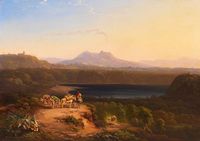
Looking at different paintings from 18th and 19th century one can see new narratives unfolding. On the paintings there are always people and viewpoints looking toward the sea, the lakes, and the surrounding landscape - the vulcanos, the mountains and vegetation. This kind of depicting creates a narrative of loneliness, looking out and waiting for something or someone out in the far (sea), longing to meet again. Even though these paintings might have an melancholic undertone, they are all portrayed in warm colors and sceneries. Referring to a narrative of enjoyment, where people understand and emphasize the surrounding landscape and the threats in it, and not letting it harm the haven they are living in. Comparing how the landscape is featured nowadays, one can say that the narratives of connecting, longing, enjoyment, change, danger, humbleness have been carried out to this day, and are still creating a feeling of a haven.
-
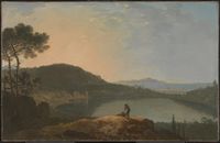 Richard Wilson - Lake Avernus and the Island of Capri (c. 1760)
 -
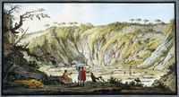 Peter Fabris - Tufa at the bottom of the crater of Monte Nuovo near Pozzuoli (1770)
 -
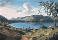 Jacob Philipp Hackert - Lago d'Averno (1794)
 -
 Friedrich Carl Ludwig and Sickler - Lacus Lucrinus (1829)
 -
 Conrad Peter Schreiber - View On The Lago D'Averno At Naples (1848)
 -
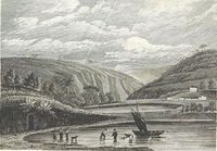
 Landscape narrative of historical and nowadays views


.jpeg)


A.2 Summary of you landscape system analysis and your development Targets
Although there are several typologies of coastal landscape, it is known that all are more vulnerable than other environments in general. It is now widely agreed that climate change and rising sea levels can cause damage to coastal areas globally.
However, we can not forget the complexity of coastal processes and other pressures in this environment. Basic human subsistence needs such as housing, food and employment have different characteristics when compared to the same needs in other areas. Challenging geomorphology, unstable and often unproductive soils, limited economics, and intense tourism make coastal areas a sensitive place.
-
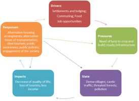 DPSIR for Averno Area

A.3 Theory reflection
European Landscape Convention’s general rules help us to find the most important features of our area, direct us to the goals supporting our area and help us to come up with our own strategical keywords for the following stages.
The theory is mainly reflected on United Nations Sustainable Development goals which are goals nr : 6 - 6.3, 6.6, 6.B (Clean water and Sanitation); 8 - 8.2, 8.3, 8.4, 8.5, 8.6, 8.9, 8.B (Decent work and Economic Growth); 9 - 9.1 (Industries, Innovation and Infrastructure); 10 (Reduced Inequalities); 11 (Sustainable Cities and Communities); 13(Climate Action); 14 (Life Below Water); 15 (Life On Land).
Regarding Italian documents, the National Landscape Charter (Carta Nazionale del Paesaggio) holds three important key points: to promote new strategies to govern the complexity of the landscape; promote education and training in culture and landscape knowledge; protecting and enhancing the landscape as an instrument of cohesion, legality, sustainable development and well-being, including economic development. Our priority would be focalizing on the point 2: “The landscape represents the most extensive and complete part of the cultural heritage: the landscape is culture.” [...] “Educating to the landscape means strengthening the identity and sense of belonging of the community so that it recognizes the value of the extraordinary collective heritage of our country and actively works for its protection. Awareness and involvement are essential for safeguarding the common goods and the recognition of a collective responsibility is fundamental to prevent the degradation of urban, rural and natural contexts, to protect the historical and artistic heritage and to stem the hydrogeological risk of a fragile territory like the Italian one.”
The overall idea would be :
- to keep and emphasize the existing cultural heritage,
- the nature of the area (coast, terrain, vegetation, lakes, inhabitants etc.);
- to reduce pollution and improve water quality;
- to create better and sustainable connections (routes, paths, lanes for non-motorized and motorized traffic);
- to make people more aware about the area of Averno (educating the locals and tourists about the nature, heritage, climate and how to keep it sustainable).
To conclude, all of the mentioned keywords create an important standing point for the area’s development. Enhancing these keywords, the place becomes alive. It becomes more popular among tourists who are interested in the cultural heritage and the nature (so called ´´slow tourism´´ for the people that are interested in rural life, fresh produce and getting the real Italian countryside experience), which creates the need for small and local businesses etc, creating job opportunities for all the locals living in the area. For the locals and tourist to have a better flowing mode we need to reduce the pollution of water, create better sustainable connections between the areas, the people and the coast.
A.4 References
- AUCELLI, P., et al., Coastal landscape evolution of Naples (Southern Italy) since the Roman period from archaeological and geomorphological data at Palazzo degli Spiriti site, Quaternary International (2017), https://doi.org/10.1016/j.quaint.2017.12.040
- EMBLETON, C.; EMBLETON-HAMANN, C. (editors) Geomorphological Hazards of Europe. Elsevier. Amsterdan, 1997. https://books.google.de/books?isbn=0080532489
- LINS-DE-BARROS, F. M. Análise integrada da vulnerabilidade costeira e dos riscos associados. Conference paper, presented at VI Congresso em Planejamento e Gestão das Zonas Costeiras em Países de Expressão Portuguesa, At Cabo Verde, 2011. https://www.researchgate.net/publication/273656524_ANALISE_INTEGRADA_DA_VULNERABILIDADE_COSTEIRA_E_DOS_RISCOS_ASSOCIADOS
- SOLDATI, M.; MARCHETTI, M. (editors) Landscapes and Landforms of Italy. Springer International Publishing. Switzerland, 2017. https://books.google.de/books?isbn=3319261940
- https://en.wikipedia.org/wiki/Naples#Geography
- http://www.glaciologia.it/wp-content/uploads/FullText/full_text_22_1/08_GFDQ_22_1_Milia_73_78.pdf
- https://www.tandfonline.com/doi/full/10.1080/17445647.2017.1300611
- https://en.wikipedia.org/wiki/Lake_Avernus
- https://it.wikipedia.org/wiki/Pozzuoli
- https://www.researchgate.net/profile/Jose_Marengo/publication/317351229_Impacto_vulnerabilidade_e_adaptacao_das_cidades_costeiras_brasileiras_as_mudancas_climaticas_Relatorio_Especial_do_Painel_Brasileiro_de_Mudancas_Climaticas/links/5935ca2ea6fdcc89e708dc36/Impacto-vulnerabilidade-e-adaptacao-das-cidades-costeiras-brasileiras-as-mudancas-climaticas-Relatorio-Especial-do-Painel-Brasileiro-de-Mudancas-Climaticas.pdf
- http://seer.cgee.org.br/index.php/parcerias_estrategicas/article/viewFile/325/319
- http://www.percorsicumani.it/progetto-percorsi-cumani/
- https://www.slowfood.it/chi-siamo/che-cosa-facciamo/
- http://www.ilgiardinodellorco.it/
- https://www.fondoambiente.it/news/la-carta-nazionale-del-paesaggio
- https://s3-eu-west-1.amazonaws.com/fai-internal/document/Carta+nazionale+del+paesaggio_MiBACT+Osservatorio+nazionale+paesaggio.pdf
- https://www.coe.int/en/web/landscape
Phase B: Landscape Evaluation and Assessment
B.1 Assessment Strategy
Our goal is to evaluate, work through and map the area according to our previous strategy, find out the problems concerning the population, environment and the special landscape, making our design relevant and helpful for the local population.
We aim to have a developing, sustainable, coherent and enjoyable environment, that emphasizes the importance of sustaining the nature and heritage, which is made possible by creating/offering different systems into the landscapes( main idea is to create different connections: between natural areas for the inhabitants and the people, tourism and the area over all, etc).
We understand that such a delicate landscape needs to be preserved, but also provide good quality of life for its population. Therefore, we believe that combining cultural and natural preservation with tourism can benefit both the inhabitants and the environment. Said that, we have mapped the green infrastucture - its particularities and potentially attractive areas, the connections - mobility and distances to the points of interest and Tourism - considering the most important leisure areas in every field of interest, from roman ruins to local gastronomy.
-
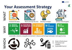 Strategic approach

B.2 Mapping
Map 1: Green Infrastructures
On this map, we tried to map the green infrastructural areas or approaches, because green infrastructures is an important approach which aims to restore, protect or enhances the quality of natural water cycle. This will in turn protects the ecosystem and ensures the safety of the community structure. These green infrastructures have a direct impact with the existing water areas namely the lake Averno & the lake Lucrino. To get a detailed understanding of this, we analyzed the inter-relation among the green, blue and gray infrastructures and as we can see, there are basically four different areas that serve the purpose. Lake Averno is surrounded by the regoinal park lands and it also falls under the protected zone. Towards the North-East outskirts we have mainly valuable agricultural land and towards the coast we also have coastal green zone. An important thing of these green areas can be noticed that, almost 70% of these green zones are the part of Natura 2000 which ensures the long term survival of various threatend species and habitats. To get a visual idea of the degree of local intervention in these green areas we also tried briefly to map some important infrastructures which are represented as little points of interest in our green infrastructural map.
-
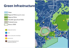 The green areas compose a very important share of touristic attraction in the area, being fundamental both for the ecological and financial aspects

Map 2: Connections
Connections always have a significant role, through them cities, towns, villages can develop faster and easily, most of all when there are good connections.
On the visualisation ``Connections 1´´ we brought out different existing ways of connecting in and around the area ( by bus, by bike, by foot, by car, by train and the visual connection) with estimated distances. In addition the near-by settlements/cities were marked down as well, to show how small are the distances between different places and how delightful and easy it would be for the local people and (local) tourists as well, to connect with our area.
On the map ``Connections 2´´ we highlighted the main existing, non-existing, possible connections and the suburb areas that belong to our study area: Monterusciello, Arcofelice (with a key role due to the presence of the hospital “La Schiana”) and Rione Toiano, a popular neighborhood built after the bradyseism of 1970 on the slopes of Monte Gauro for the citizens of Pozzuoli who were evicted from the Rione Terra and from the historical center. This area is the center of administrative activity, there some schools and some commercial activites. This is the main reason why the connection with the other areas should be improved.
The types of connections in the area are:
The (main) good connections (in green) are: -Ring road A56: It is the main urban axis of the city crossing it from the east (Capodichino aeroport) to west (Phlegraean area of Pozzuoli) until Averno area. At this point it is connected with Domiziana ss7qtr, an highway starting from Lazio region. -Main road on the coastline starting from Pozzuoli center till our area that must be improved planning bike lanes for example. -Averno lake road: Recently it has been renovated and it is a good visual connection for tourists or citizens that want to enjoy the lake view. Part of it is accessible also to cars. -Cocceio cave: this is an ancient Roman cave that had the role to connect lake Averno to Cuma. Now it is closed but the municipality of Pozzuoli has announced that probably it will be open in June 2019. Of course it will be a really good connection between these two important areas full of history and heritage. Passable connections (in orange): These type of connections are already existing, but need to be overlooked and/or renovated. It would be impportant to create green corridors, bike lanes, pathways and passages for pedestrian as well, not only for cars. Lack of connections (in red): As you can see from the legend in red we have highlighted the lack of connection, most of all along the coastline. A visual connection is missing due to the presence of the train lane, but also connections to the public beaches that must be improved, at least marked. Most of the coastline is characterized by the presence of private beach facilities, restaurants and bars that have occupied the entire small strip of beach: this, of course, does not help the free use of the beach. Possible connections(in yellow): There drawn connections are our understanding of the possible places and ways that need to be created to connect different parts of our area (the coast with the area, the people with the coast etc), making the area more nature, heritage and people friendly and also helping the place to develop.
Another big issue is the type of connection. Mainly people use cars and motorbikes. The only good way of connecting with area(for the tourist people from other cities) is with the train, which is stopping in front of Lucrino lake. Bus connections in the area are really bad, the place is lacking of bike lanes and pedestrian paths, to ramble around in the area. These are the reason why tourists (national and initernational) have always problems to reach this area and why locals/people living near-by don't spend so much time in the area.
-
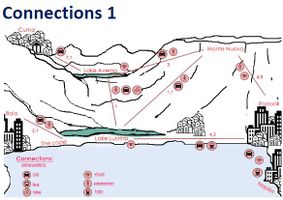 Connection of the area near lake Averno, Lucrino, Mont Nuovo, the coast and the cities nearby. Important to show the types of connections in the area indicating to the possibilites not only for the international but also for the domestic tourists.
 -
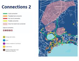 Connection types of the area - bringing out the problems and possibilities.


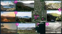
Map 3: Tourisms
Tourism in the area has a strong potential given by the diversification of the audience to which it is addressed and by the variety of interests, from the naturalistic area there is a strong interest in possible trekking and birdingwatches given the fauna, while in the coastal area there is greater l interest in underwater archaeological and bathing tourism, particularly the presence of thermal infrastructures that carry out ancient spa traditions, the aim is to enhance naturalistic sites, to put them on the tourism market, but at the same time to avoid uncontrolled consumption of the territory and resources.
-
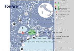 Tourism in the area

B.3 Problem definition and priority setting
Regarding our priorities and targets, we took into consideration the main important Co-land goals and we thought of some secondary ones, which will lead to the development of our area. To begin with the decent work and economic growth - we thought it is necessary to attract a new flux of people by creating new job opportunities and improving the local economy. Reaching the next step, in order to have sustainable cities and communities it is necessary to control the development not only of the tourism, but also of the existing infrastructure, to highlight the cultural heritage and last but not least to connect the social groups. To improve the life below water there should be taken into consideration both a better water management and the protection of the whole aquatic ecosystem. Lastly, speaking about the life on land we thought it is mandatory to preserve and connect the natural ecosystem and increase the quality of life.
- Give a summary of the major findings of your mapping process, what are the problems/potentials identified?
- Draw a problems/potentials map
- Set priorities for the most relevant issues
-
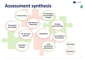 Potentials and problems
 -
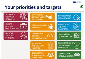 Priorities and targets


B.4 Theory reflection
A study conducted by PEER research team on identifying some knowledge gaps for the assessment of Europe's ecosystem service had three objectives i.e. to demonstrate present research capacity for developing maps, to identify methods for assessing on ecosystem service targets and to assess policies affecting the current and future management of ecosystem services. Environmental, Transportation & Regional development policies were some important domains which were included in the assessment.
Mapping was a crucial part which led to various decision making phases such as identification and framing, discussions about solutions and as visualisation for alternatives (simulations), improving the targeting of measures etc. Various challenges were identified through the process. Similar to the scenerio of Averno, ecological aspects played an important role which led to the creation of 3 distinctive maps. Maps were generated which can be used for biodiversity protection areas and showing relationships especially for potential conflicts between different land uses, Transportation improvement which identifies alternative use of transport routes and extending the possibilities of the area in question and regional economical development through incorporating tourisms and some important factors. Some common challanges were also identified as sometimes the scales were not identical, mismatch of highly accurate maps and local context or sometimes high degree of knowledge or informations were required which can't be found easily etc.
In ESS study report, recreational activities were defined as the recreational pleasure that people derive from natural or managed ecosystems which can be a crucial element for the evaluation and assessment of the area mapping. The benifits can be obtained by carefully identifying the facilities from these three maps in question. Through implementing various scenerio maps such as Dot (density) maps, Marker maps, Choropleth maps, Proportional symbol maps etc. the oveall maps for this stages are created. The maps were simplified by incorporating same basemap for them. Datas from previous studies such as DPSIR, various types of land use etc. were also used in the process. From these maps a mental picture or vivid generalisation of the area is obtained. Although much of the limitations were not possible to show, the maps provide a somewhat logical, understandable information to conduct further work which facilitates in obtaining the five main ideas stated previously.
B.5 References
https://www.peer.eu/files/user_upload/user_upload/publications/PEER_report_3_phase_1.pdf
https://www.researchgate.net/publication/315074237_What_to_map
http://ec.europa.eu/environment/eia/pdf/EIA_guidance_EIA_report_final.pdf
http://ec.europa.eu/environment/nature/natura2000/index_en.htm
http://ec.europa.eu/environment/nature/ecosystems/index_en.htm
https://it.wikipedia.org/wiki/Pozzuoli
https://it.wikipedia.org/wiki/Autostrada_A56
Phase C – Strategy and Master Plan
C.1 Goal Setting
- Define strategic planning objectives based on the evaluation findings
- Link back to your original targets from section one and the Development Goals
- 150 words text contribution
C.2 Spatial Strategy and Transect
- translate your strategic goals into a vision
- develop a spatial translation of your vision
- exemplify your vision in the form of a transect with concrete interventions
- add map(s) and visualizations
-
add caption here
-
add caption here
-
add caption here
-
add caption here
C.3 From Theory of Change to Implementation
- For implementing your vision: Which partnerships are needed? Which governance model is required?
- Who needs to act and how? Draw and explain a change/process model/timeline
- Which resources are needed? On which assets can you build?
- add 150 words text and visuals
-
add caption here
-
add caption here
C.4 References
- give a full list of the references you have used for this section
D. Process Reflection
- Reflect in your intercultural and interdisciplinary team on the outcomes of your study
- Which limitations were you facing?
- What have you learnt from each other?
- What would you do differently next time?
- You can also use diagrams/visuals
- 250 words text