Case Study E: Cuma
>>>back to working groups overview
| Area | please enter the area name here | |
| Place | please enter the town/village name | |
| Country | please enter the country here | |
| Topics | please enter the main coast-related topics here | |
| Author(s) | Please enter your name(s)- optional | |

| ||
Rationale
- Why do you think this case is relevant? What is your hypothesis considering the landscape challenges?
- Format: 3-4 sentences
Location and scope
You can edit this map with the map editor
A Landscape System Analysis
A.1 Landscape layers and their system context
Geomorphology, landscape units and coastal typology
Due to volcanic eruptions and the variations of the sea-level, lake environments and palustrine wetlands had formed. As we can see on the maps below, these palustrine wetlands had started to disappear, probably because of the fast urbanization of the zone and due to the climate change.
The coastal plain is characterized by a complex volcanic-sedimentary sequence formed by sands, silts, silty clays and volcanoclastic sediments, resting on a substrate of yellow tuff and trachytic laves.
The altitude ranges between 0-15 meters, from the sea troward the inland, by beach-dune systems followed by a low inclination zone back-dune and slope areas belonging to volcanic reliefs.
On the nordic part of the zone we can find low-lying sandy shore type of coast, in south there are rocky cliffs.
-
 Landscape units in 1822
 -
Landscape units in 2018

Land use
- Urban area, agricultural land, forest, water, and infrastructure
- Cuma is known for being the oldest Greek colony in mainland Italy. In the ancient time, the settlement area was located around the Monte di Cuma hill. The city grew eastward. The red lines on the map indicate the ancient Roman roads. The right one branches off to Arco Felice. The purple lines show the main roads that are used before 1886.
- Another map illustrates the city of Cuma in present time. The urban area has spread all over Cuma and Fusaro, especially around Fusaro Lake. A large amount of green area has been replaced by residential and commercial areas.
- There is a possibility that more green area might be destroyed to support the growth of urban fabric in the future to support the increasing number of population.
- Therefore, the driving forces for the land use evolution are population growth and tourism.
-
 Landuse of ancient Cumae
 -
 Landuseof present day Cuma


Green/blue infrastructure
- As we can see on the images below, both green and blue infrastructures have suffered major changes. The lake and the wetlands in the nord of the territory had disappeard and were replaced with a canal system. The contiguous green spaces is reduced to half of it’s size from 1822 and was devided to smaller areas. The existing green area is a part of the Natura 2000 network (SCI – Sites of Community Importance), which is supporting the conservation of it’s habitat, but the expansion of the built-up areas is representing a major threat.
-
 Green and blue infrastructure in 1822
 -
 Green and blue infrastructure in 2018
Actors and stakeholders
- The main control is in the hand of the administrative sectors, like the region, municipality and the city. The investors and the NGO’s both have high interests, but they are less powerfull as the actors mentioned before. Inhabitants and tourist are the most powerless, but they are very affected by the decisions of the other actors.
-
 add a caption

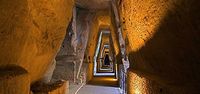
Sacred spaces and heritage
- The Archeological park of Cuma is one of the most important in Italy, it represents the history and the identity of Cuma's territory. The park holds some heritage spaces like The "Antro della Sibilla", The Thermae of the forum, The Juppiter's temple, the Apollo's temple and the "Masseria del gigante".
-
 Map of Archeological area of Cuma
 -
 Antro della Sibilla
 -
 Thermae of forum
 -
 Apollo's temple
 -
Apollo's temple
-
 Juppiter's temple


Visual appearance and landscape narrative
- Cumae is located in the Phlegraean Fields of Naples, Italy. This area is characterized by fumaroles, thermal waters, extinct volcanoes and lakes. It is the place where the four elements of nature – fire, water, earth and air – coexist in perfect harmony. This area was a great inspiration for famous painters and writers. Many discoveries happened in this area from the seventeenth to the nineteenth century. Also, the richest students from Europe came to this area to learn about arts and cultures.
The paintings in the slide show how these artists, described the landscape and tell a story in their paintings about the famous legends of Cumae. Although these paintings describe a dark scene, they represent a beautiful landscape of the Italian coast.
Micheal Ayrton wrote and painted the landscape of Cumae and its famous myths. “the legend grew in me, forced itself upon me and emerged in the form of reliefs, bronzes, drawings and paintings in various media”. He speaks of a time when this type of landscape “Greek landscape” possessed him.
River Landscape with Apollo and the Cumaean Sibyl, painted by Salvator Rosa 1655. This painting highlights his ability as a landscape painter: showing a desolate landscape scene, an isolated inlet of the sea, surrounded by towering cliffs of rough and rugged stone. On the right a dark crag which towers against a stormy summer sunset. jagged rock, trees sprouting from it at strange angles. Despite the darkness of the scene, the painting is still representing a beautiful landscape.
Coast View with Apollo and the Cumaean Sibyl, Claude Lorrain’s painting from about 1645-49. This painting not only describes the landscapes but also tells a story about the famous legend of Apollo who is holding his lyre in his left arm, trying to persuade the seated Sibyl, to let him take her virginity. Around them are the ruins of classical buildings and a stand of tall trees, showing in the background the beautiful coast of Italy.
Lake Avernus: Aeneas and the Cumaean Sybil, (second version)1814 or 1815 by JMW Turner, a mythological painting. The painting represents a mythological landscape showing the beautiful setting of Lake Avernus. In the distance is Baiae and the cliffs of Cape Miseno. In the painting the Sibyl, who does not show her years, holds aloft a golden sprig rather than a bough, and Aeneas stands with his back to the viewer, as if he too is enjoying the view.
The Golden Bough (1834) by JMW Turner. The painting shows a certain setting in the legend story where Sibyl stands on the left, radiant in white light, and holding aloft a more substantial golden branch. Her right hand holds a golden sickle used to cut that branch. Down towards Lake Avernus are the Fates, dancing around another white glow. A couple of female companions of the Sibyl rest under the tree. In the right foreground is a snake, a symbol of the underworld.
-
 "River Landscape with Apollo and the Cumaen Sibyl by Salvator Rosa (c.1655)"
 -
 "Joseph Mallord William Turner (1775–1851), Lake Avernus: Aeneas and the Cumaean Sybil (1814-15)"
 -
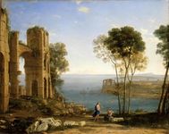 "Claude Lorrain (1604/1605–1682), Coast View with Apollo and the Cumaean Sibyl (c 1645-49)"
 -
 "Joseph Mallord William Turner (1775–1851), The Golden Bough (1834)"


A.2 Summary of you landscape system analysis and your development Targets
If the driving forces continue as they are now without regulations or management, the landscape will deteriorate further; for example, there will be less blue and green areas infrastructure while the urban area continues to grow. There are 3 issues that can be linked to the UN Sustainable Development Goals which are:
- No. 11: Sustainable Cities and Communities
- No. 14: Life Below Water
- No. 15: Life On Land
-
 DPSI(R) Analysis on the Cuma area

-
 More population-More tourists-More Pollution-Less Green and Blue

A.3 Theory reflection
The United Nations Sustainable Developement Goals aim for a better and more sustainable future for all. Goal nr. 14 is focusing on keeping the marine environment clean and healthy by regulating the activities such as reducing overfishing, marine pollution and acidification. Providing access for small-scale artisanal fishers to marine resources and markets (14.B) is also important not only to keep the sea clean, but also for tourism. Goal nr. 17 - Revitalize the global partnership for sustainable development will help the area to develope in every way much faster and efficiently. To reach this goal, all stakeholders (administrative sectors, investors, NGO’s, inhabitants and tourists) must collaborate.
One of the main challenges is to protect the existing natural areas. The EU Biodiversity Strategy is setting out 6 targets and 20 actions to halt the loss of biodiversity and ecosystem services in the EU by 2020. The first Target of the strategy is to protect species and habitats, which is crucial especially in the case of the existing green space. The protected area must get enough funding (Action 2), has to involve citizens and improve the enforcement of the nature directives (Action3), and make the monitoring and reporting of the EU nature law more consistent, relevant and up-to-date; provide a suitable ICT tool for Biodiversity (Action 4). Maintaining and restoring the ecosystems (Target 2) includes three specific actions to ensure that ecosystems and their services are protected and enhanced. By restoring ecosystems, and maintain their services and promote the use of green infrastructure (Action 6) the fragmented green area could be complete again. In this case is also very important to make fishing more sustainable and seas healthier (Target 4) and help stop the loss of global biodiversity (Target 6) by restricting the activities in the zone.
A.4 References
- www.mapire.eu
- https://wwz.ifremer.fr/dce/content/download/69291/913220/file/DPSIR.pdf
- https://www.un.org/sustainabledevelopment/sustainable-development-goals/
Phase B: Landscape Evaluation and Assessment
B.1 Assessment Strategy
- Based on the hypothesis derived from your previous landscape systems analysis you are now asked to define the goals for assessing the landscape. Your assessment is the basis for evaluating the landscape status.
- Which elements and phenomena need to be mapped, why and how?
- This a text contribution, max 250 words
B.2 Mapping
- As defined by your assessment strategy you conduct the mapping and present your findings here
- As a minimum, at least three different themes need to be mapped, you may choose more if needed
-
briefly explain the findings of your mapping
-
briefly explain the findings of your mapping
-
briefly explain the findings of your mapping
B.3 Problem definition and priority setting
- Give a summary of the major findings of your mapping process, what are the problems/potentials identified?
- Draw a problems/potentials map
- Set priorities for the most relevant issues
-
add caption here
B.4 Theory reflection
- Please reflect the assessment and evaluation methods used based on at least three readings
- Did you encounter limitations'
- 200 words test contribution
B.5 References
- give a full list of the references you have used for this section
Phase C – Strategy and Master Plan
C.1 Goal Setting
- Define strategic planning objectives based on the evaluation findings
- Link back to your original targets from section one and the Development Goals
- 150 words text contribution
C.2 Spatial Strategy and Transect
- translate your strategic goals into a vision
- develop a spatial translation of your vision
- exemplify your vision in the form of a transect with concrete interventions
- add map(s) and visualizations
-
add caption here
-
add caption here
-
add caption here
-
add caption here
C.3 From Theory of Change to Implementation
- For implementing your vision: Which partnerships are needed? Which governance model is required?
- Who needs to act and how? Draw and explain a change/process model/timeline
- Which resources are needed? On which assets can you build?
- add 150 words text and visuals
-
add caption here
-
add caption here
C.4 References
- give a full list of the references you have used for this section
D. Process Reflection
- Reflect in your intercultural and interdisciplinary team on the outcomes of your study
- Which limitations were you facing?
- What have you learnt from each other?
- What would you do differently next time?
- You can also use diagrams/visuals
- 250 words text