Case Study F: Monte di Procia-Miseno
>>>back to working groups overview
| Area | Monte di Procida-Miseno | |
| Place | Monte di Procida, Naples | |
| Country | Italy | |
| Topics | please enter the main coast-related topics here | |
| Author(s) | Alexandru Moldovan, Annely Jürimets, Daniele Petagna, Elena Pop, Gheorghe Madalina, Narges Doosti | |

| ||
Rationale
Monte di Procida-Miseno is located in Campania in the province of Naples, located precisely on the Phlegraean peninsula. It represents one of the most particular and fascinating areas of Italy, characterized by paths, panoramic views and historical monuments. This territorial wealth is contrasted with various problems arising from low quality management, construction of illegal buildings and pollution of the marine environment. Our priority is to improve the environment, through the design of green and blue infrastructures, in such a way as to preserve the characteristic landscape, thus stimulating development from a tourist point of view.
Location and scope
You can edit this map with the map editor
A Landscape System Analysis
A.1 Landscape layers and their system context
Geomorphology, landscape units and coastal typology
The territory of Monte di Procida-Miseno represents the most extreme part of the Phlegraean peninsula and its territorial characteristics are substantially linked to the evolutionary history of the Campi Flegrei area.
The area originated from two serious eruptions, the first occurred 39000 years ago (eruption of the Ignimbrite campana) and the second 12000 years ago (eruption of the Tufo giallo napoletano). The eruptions probably caused the collapse of the caldera, a semicircular depression, in which then developed a complex volcanic system.
Every event of volcanic deposition and erosion occurred over the centuries has contributed to the definition and formation of the coastal landscape as it appears today. Observing the coastal morphology characterized by layers of rocky sediments, it is possible to recognize an older section, corresponding to the lower part, composed of ash and lapilli, and a relatively younger section, the highest part, made of pumice and tuff.
The volcanic nature of the place has contributed to the formation of natural beauties such as the islet of San Martino. At the beginning the island, composed mainly of pozzolana, was connected to Monte di Procida but, in 1488, due to a tsunami, it broke off from the coast.
The area of Miseno is characterized by six volcanoes in a state of quiescence that have influenced the morphology of the territory characterized by an alternation of high and low topography. The orography of the area is mainly hilly, exception of a flat area near Lake Miseno. From a geological point of view, Capo Miseno is formed by yellow tufa rock, only at the top it is covered by the typical ash of Campi Flegrei, the white pozzolana.
-
 The two serious volcanics eruptions
 -
 View of Monte di Procida-Miseno
 -
 Islet of San Martino


Land use
- settlements, infrastructure, agriculture, resource extraction, natural areas, energy production...
- description of evolution, status quo and driving forces, is the land use likely to change? Why is that? (approx 200 signs)
- add 1-2 graphical representations to the image gallery, you can add more if you like
-
add a caption
-
add a caption
-
add a caption
Green/blue infrastructure
- What are the major potential elements of a green/blue infrastructure network? Are these likely to change/disappear? Why is that?
- You find my background material on green infrastructure in our reading list
- add 1-2 graphical representations to the image gallery, you can add more if you like
-
add a caption
-
add a caption
Actors and stakeholders
- Who is driving changes in this landscape? Who is affected by those changes?
- Draw a stakeholder and/or power map: Who is affected highly but with low power? Who has high power but is not affected?
-
add a caption
Sacred spaces and heritage
The territory of Monte di Procida-Miseno was founded around the 6th century BC and throughout the ages, many monuments and sacred spaces of exceptional historical value have been handed down.
The oldest church, most probably, dates back to 1644 and is dedicated to the Madonna Assunta, since, according to legend, a picture of her was found on the beach. Over time, the church has undergone numerous maintenance work. Today it presents itself with a classical facade characterized by columns and marble decorations. The interior is divided into three naves, where the statue of the Madonna Assunta, maked by the Neapolitan sculptor Francesco Verzella, is safeguard.
Over the past twenty years, remains of the Roman Necropolis have been found in Cappella, a hamlet on the border between Bacoli and Monte di Procida. These are funerary structures dating back to a period between the Late Republican age and the Middle Empire, which welcomed deceased members of the Classis Misenensis and their relatives. Inside there is a monumental mausoleum and four funerary rooms that have small recess on the walls intended to hold the ashes.
Another important Roman archaeological monument, built in the Augustan age, is the Piscina Mirabilis, a huge water cistern, with a capacity of 12,600 mc, that represented the arrival point of the Serino aqueduct. The monument, dug out of the tufo, has a rectangular plan and consists of four rows of twelve pillars that divide the space into five long aisles and thirteen short that support barrel vaults.
The territory is also famous for the beautiful panorama that can be seen from the various paths, including the Sentiero del faro that descends towards Miliscola. A footpath from the sea, is lost among old villas, farms, and numerous ruins including an anti-Saracen tower dating back to medieval times, known as Torre Bassa, which had the function of protecting and monitoring from the phenomenon of banditry.
-
 Map of the sacred spaces and heritage in Monte di Procida-Miseno
 -
 Remains of the Roman Necropolis
 -
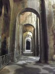 Piscina Mirabilis
 -
 Sentiero del faro


Visual appearance and landscape narrative
In a famous epic poem by Virgilio (Virgil) which is known by all as ‘Aeneid’ (19th-29th BC), it had been described that there was trumpeter of 'Enea' named 'Miseno', and his rival 'Tritone' was envious of his skill in playing the instrument. Tritone challenged Miseno and, realizing his talent, killed him by throwing him into the sea. Miseno's body was found by his friends, they buried him at the top of the promontory. This promontory took its name from the trumpeter Miseno. In the eighteenth century, Italian painter and draftsperson named Carlo Bonavia, described a view of the islands of Procida from the Miseno beach. Later in 1819, François Gérard (1770-1837) painted a scene 'Corinne at Cape Miseno' from a novel called 'Corinne ou l'Italie', an 1807 novel by 'Madame de Staël'. Our perception of the scenes of old Miseno is expressed in a way that before the nineteenth century that Miseno was depicted in literature and other forms of art, it had a fearful and uneasy feeling because of the active volcano in the background with the gloomy foggy atmosphere. But today, those specific views are the most popular landmarks, mainly visited for the purpose of tourism, and a safe, peaceful, and spectacular place for the locals to get away from their everyday life. As we are living in a world that social media has a strong role in expressions of the places and feelings by people, we came up with the most ‘hashtag-able’ photos which were taken in those areas shown on the right lower map. Also, views from the high cliffs seem to have more visitors. This brings the capacity of those beaches to be developed and maintained in future strategies.
-
Corinne at Cape Miseno (1819) by François Gérard (1770-1837)
-
View of the islands of Procida from the Miseno beach by Carlo Bonavia (1751-1788)
-
Most popular viewpoints perceived from the most photo taken and shared on social media
A.2 Summary of you landscape system analysis and your development Targets
- You can summarize your findings with an DPSI(R) Model or a Spider Diagram
- Link back to the Sustainable Development Goals: Which goals are at risk?
- What is your hypothesis for this landscape?
- Visualise your hypothesis with one graphic/pict
- Are there any existing initiatives taking action in this landscape? Do you have a critical perspective on that?
- Add text and visuals
-
explain your analysis briefly in the caption
-
explain your hypthesis briefly in the caption
A.3 Theory reflection
- Reflect on at least three international policy documents in relation to their local landscape case
- choose one international, one European and one national document
- You can choose references from our reading list
- Scope: 250 words
A.4 References
http://www.ov.ingv.it/ov/it/campi-flegrei/storia-eruttiva.html
http://www.montediprocida.com/wp/
Phase B: Landscape Evaluation and Assessment
B.1 Assessment Strategy
- Based on the hypothesis derived from your previous landscape systems analysis you are now asked to define the goals for assessing the landscape. Your assessment is the basis for evaluating the landscape status.
- Which elements and phenomena need to be mapped, why and how?
- This a text contribution, max 250 words
B.2 Mapping
- As defined by your assessment strategy you conduct the mapping and present your findings here
- As a minimum, at least three different themes need to be mapped, you may choose more if needed
-
briefly explain the findings of your mapping
-
briefly explain the findings of your mapping
-
briefly explain the findings of your mapping
B.3 Problem definition and priority setting
- Give a summary of the major findings of your mapping process, what are the problems/potentials identified?
- Draw a problems/potentials map
- Set priorities for the most relevant issues
-
add caption here
B.4 Theory reflection
- Please reflect the assessment and evaluation methods used based on at least three readings
- Did you encounter limitations'
- 200 words test contribution
B.5 References
- give a full list of the references you have used for this section
Phase C – Strategy and Master Plan
C.1 Goal Setting
- Define strategic planning objectives based on the evaluation findings
- Link back to your original targets from section one and the Development Goals
- 150 words text contribution
C.2 Spatial Strategy and Transect
- translate your strategic goals into a vision
- develop a spatial translation of your vision
- exemplify your vision in the form of a transect with concrete interventions
- add map(s) and visualizations
-
add caption here
-
add caption here
-
add caption here
-
add caption here
C.3 From Theory of Change to Implementation
- For implementing your vision: Which partnerships are needed? Which governance model is required?
- Who needs to act and how? Draw and explain a change/process model/timeline
- Which resources are needed? On which assets can you build?
- add 150 words text and visuals
-
add caption here
-
add caption here
C.4 References
- give a full list of the references you have used for this section
D. Process Reflection
- Reflect in your intercultural and interdisciplinary team on the outcomes of your study
- Which limitations were you facing?
- What have you learnt from each other?
- What would you do differently next time?
- You can also use diagrams/visuals
- 250 words text