Southern Coast of the Caspian Sea: Difference between revisions
| (59 intermediate revisions by 6 users not shown) | |||
| Line 19: | Line 19: | ||
| '''Author(s)''' || style="background:Lavender"|''Mohamadreza, Negar, Amirhossein, Haniyeh'' | | '''Author(s)''' || style="background:Lavender"|''Mohamadreza, Negar, Amirhossein, Haniyeh'' | ||
|- | |- | ||
| colspan="3" align="center" style="background:silver"| [[File:Presentation11024px-Bolvare Bandar-e Anzali.jpg]] | | colspan="3" align="center" style="background:silver"| [[File:Presentation11024px-Bolvare Bandar-e Anzali.jpg|400px]] | ||
|- | |- | ||
| ||style="background:Lavender"| | | ||style="background:Lavender"| | ||
| Line 43: | Line 43: | ||
<gallery caption=" " widths="200px" heights="150px" perrow="5"> | <gallery caption=" " widths="200px" heights="150px" perrow="5"> | ||
File:Casestudy anzali1.JPG| | File:Casestudy anzali1.JPG|Current situation of Geomorphology, landscape and coastal typology of suggested area | ||
File:Casestudy anzali2.JPG| | File:Casestudy anzali2.JPG| | ||
</gallery> | </gallery> | ||
| Line 98: | Line 98: | ||
<gallery caption=" " widths="200px" heights="150px" perrow="5"> | <gallery caption=" " widths="200px" heights="150px" perrow="5"> | ||
File:Boolvar-anzali-1350-gajamoo.jpg| | File:Boolvar-anzali-1350-gajamoo.jpg| This picture back to 40 years ago and it shows this area always is used by the people as a promenade. | ||
File:Anzali.jpg| | File:Anzali.jpg|Coastal boulevared of Bandar Anzali. | ||
File:AC-anzali-Menareh-mani-golnazi.jpg| | File:AC-anzali-Menareh-mani-golnazi.jpg|The longest instrument ever remained is the lighthouse (minaret), built in 1815 and located in the center of the city. | ||
</gallery> | </gallery> | ||
| Line 185: | Line 185: | ||
*''As defined by your assessment strategy you conduct the mapping and present your findings here'' | *''As defined by your assessment strategy you conduct the mapping and present your findings here'' | ||
*''As a minimum, at least three different themes need to be mapped, you may choose more if needed'' | *''As a minimum, at least three different themes need to be mapped, you may choose more if needed'' | ||
<gallery caption=" " widths="500px" heights="200px" perrow="1"> | <gallery caption=" " widths="500px" heights="200px" perrow="1"> | ||
File: | File:Practical Theme-1.jpg|'''''Practical Theme-Slide 1:''' Following the factors of this theme obtained from Bluehealth Environmental Assessment tool guide, the principles of planting design and safeguarding have been assessed within the landscape according to the very valuable sources; ''The Planting Design Handbook, 2nd edition, Nick Robinson and Site Planning and Designing Handbook, 2nd Edition, Thomas H. Russ''. A comparative assessment has been evaluated within the promenade. The outcomes show for some essentials of those two principles, there are low functionalities which have significant impacts on the quality of landscape. For example, the openness level of view which plays a very important role of enjoying the landscape is degraded in some spots due to the choosing unsuitable types of plants. That is why in some paths there is a feeling of being in a maze! Also, the privacy level should be adjusted to the semi-level which is not respected in some spots. Those spots represent the feeling of psychological unsafety for most users specially elderlies when they are occupied by suspicious people.'' | ||
File:Case | File:Practical Theme-2.jpg|'''''Practical Theme-Slide 2:''' Also, the density and arrangement of plants play very significant roles for the quality of landscape in terms of readability and buffering for noise pollution. Well by checking the outer boundary of landscape it was revealed that the new planted trees are too young with unsuitable canopy size which cannot absorb the noise from street. Also in term of readability in some paths, the sense of getting rid of a maze is appeared where users have difficulty to determine and follow the visual signs. Being unintentionally confused records a very bad image of landscape in users’ minds! For the safeguarding we found out the current conditions are not completely matched with the usual principles. For example, there should be lifebuoy (life ring) in specific distances and also the pier should be officially closed when it’s not in use or the safety of railing principles should be respected like its anti-climbing aspect for kids, its net proportion and its contrasted color than its background.'' | ||
File: | File:Case one.jpg|'''''Perceptual Theme-Slide 3:'''Street lighting provides a number of important benefits. It can be used to promote security in urban areas and to increase the quality of life by extending the hours for those activities which could take place at night. Here in Bandar Anzali, darkness as well as unappropriated light dispersion in many parts of this green route have created an undesirable situation for those citizens who are enthusiastic to use this promenade. Clearly, because of lack of light in most sectors, these areas are totally unusable during the night, and the utilization of that is only limited to young people.'' | ||
File: | File:Case 3.1.jpg|'''''Physical Theme-Slide 4:'''This picture shows that there isn't proper sign and signage for vehicles and pedestrian and about lightening design there is also lack of appropriate light streets at nights. regarding the third row these pictures are showing inadequate seat status, in some point they are ruined and in some areas there is nothing and people are using their own chair and the last one is showing regarding lack of cycle path and it's parking in this area.'' | ||
File:Case 3.2.jpg|'''''Physical Theme-Slide 5:'''These small shops or street-trading stalls are located in this area and only attract young people especially those youngers who are using shisha and this places are not suitable for family gathering and elder people. about the parking as an important issue as you see only one parking we have at Southern part of this area and it shows with blue circle in the map and with the scale of this area it needs to be allocate more spots for car parking and other problems are about public facilities such as recycling facilities, public toilets and so on.'' | |||
</gallery> | </gallery> | ||
== B.3 Problem definition and priority setting == | == B.3 Problem definition and priority setting == | ||
Based on our assessment findings, we have defined the goals which help us in the planning and design process. The goals are also defined based on the 3 categories that we have done the analysis on maps. Besides we have considered the time and would like to achieve the goals in a period of short, mid and long terms. | |||
By the planning and future design that we would want to apply, we would like to achieve a better lightening system, making a safer place and by that providing a pleasant place. These are the elements that should be solved at an early stage of our design process. | |||
The next step would be improving the green areas, increasing the safety element, enhancing the different networks of pedestrian and bicycle within and through the context. The long-term goals would be the future renovation and add more facilities to the site which is much easier to achieve in the last stage. | |||
<gallery caption=" " widths="500px" heights="200px" perrow="5"> | <gallery caption=" " widths="500px" heights="200px" perrow="5"> | ||
File: | File:Problem definition and priority setting Group06.png| | ||
</gallery> | </gallery> | ||
== B.4 Theory reflection == | == B.4 Theory reflection == | ||
As the reflection of our work so far , the limitations that we have encountered during the assessment phase and the significance of the readings and the lectures that we have got till now. | |||
Since that our case study location is in Iran and we all are living in Germany, we could not have the access directly to the site and have the active observation. So we had to search online inorder to get the data, but in some cases we were not sure about the last updated time of the information.Also we have had some difficulties with finding old literature and photos about the site. However one of the most important reason was the limited time .Since our topic is related to different majors specially psychology , we had to have multidisciplinary knowledge that we as architects and landscape architects need to study more about other majors.to be able to have a better understanding of the topic. Besides since our topic is a unique topic , no one before did the similar analysis that we could use. | |||
The major insights that we got from the readings and lectures is the Blue Health environmental assessment that lead us to the map analyses that we have done by applying a mixed use of Descriptive & Comparative assessments. | |||
== B.5 References == | == B.5 References == | ||
| Line 223: | Line 226: | ||
=Phase C – Strategy and Master Plan = | =Phase C – Strategy and Master Plan = | ||
== C.1 Goal Setting == | == C.1 Goal Setting == | ||
Following the assessments from the previous phase, improving the perceptual, practical and physical aspects as the main related themes of psychological security and safety challenges has been defined as goal for this phase. More specifically, the principles of each factor have been optimized within the proposals as an intervention in different spots which were recognized from the former phase. Due to the limitation of time and access to the site, only the main principles in each theme have been chosen to be improved. It is expected these proposals altogether can remarkably enhance the psychological security for the users of this promenade. | |||
Implementing these proposals has different levels of support for some sustainable development goals (SDGs) within this small scale coastal landscape. It can provide strong supports on goals like good health and well-being for people as Goal 3 and some targets within the Goal 11 as Sustainable Cities and Communities while goals 15 and 8 have the weaker support from our strategy. | |||
== C.2 Spatial Strategy and Transect == | == C.2 Spatial Strategy and Transect == | ||
| Line 234: | Line 237: | ||
<gallery caption=" " widths="500px" heights="200px" perrow="1"> | <gallery caption=" " widths="500px" heights="200px" perrow="1"> | ||
File: | File:Spatial vision.jpg|''Case spatial translaton vision: Actually, the chosen topic has been extracted from the circumstance of this promenade and the behavioral study of people who are closely in connection with this area. As a result of this concept, we managed to derive the name of the topic which is called, from people for people. It means by analyzing people’s behavior correctly, we would be able to prepare better situation for them. In this topic the psychological issue is the most prominent thing which has been tried by considering, practical, perceptual and physical requirements to be improved. So our strategy is based on these three columns which are directly contributing to the main goal that is a psychological improvement for the users of this promenade. In this way because of time limitation, among all existing items we tried to survey some critical parts that needed to work on. By improving some items in these three columns not only we could enhance the quality of them but also they are so helpful and effective in the psychological improvement which is shown by quality charts'' | ||
File: | File:Intervention spots.jpg|''Interventions'' | ||
File: | File:Practical theme-Slide 1.jpg|''Interventions: Practical Theme-Slide 1'' | ||
File: | File:Practical theme-Slide 2.jpg|''Interventions: Practical Theme-Slide 2'' | ||
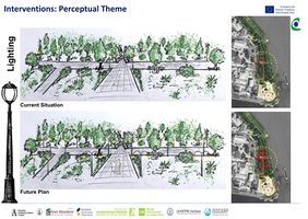
File:Case detail 2.jpg|''Interventions: Perceptual theme: Well, lighting is one of the main defects that we have faced in this region. Although, this problem is not only limited to a small sector of this area but, it has been tried to focus the most critical part. As you can see on the map the red points are showing the number and also location of park lights. While we have a large area in the yellow circle, but the number of park lights are few and there are only seven lights whereas this quantity is not enough for such a big space. In the following, the sketch on the left is showing the approximate situation of this space as well. | |||
But, in the future plan definitely we need more park lights here. But it does not mean to over- light the park, but in fact too much lighting can be just as bad as too little lighting. It is so important that we relate lighting to the evening functions of a particular space and we achieve the primary purpose in nighttime which are security and safety. So here on the below map in the future plan we have tried to create a successful lighting plan based on the pedestrians activities and families who willing to use this region as a recreational area in their vicinity and tourists as well'' | |||
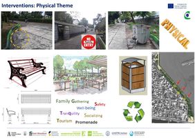
File:Case detail 3.jpg|''Interventions: Physical theme: In this phase I have chosen 3 items from 8 elements for sureying. The first one is showing an unappropriate seating in some points which in the future plan to consider new benches based on the certain standards in terms of height, width, length an so on. The second one is illustrating regarding trading stalls where all of them are not suitable for family gathering, tourists and also elderly people and in the master plan some places like cafes and restaurants in this promenade will be considered. The third one is showing concerning recycle facilities as an important issue in public places and parks. They must be situated in proper situation with also standard scattering and certain distances. It also should be noticed the recycling issue is important and noticeable.'' | |||
</gallery> | </gallery> | ||
== C.3 From Theory of Change to Implementation == | == C.3 From Theory of Change to Implementation == | ||
*'' | *''From the actors and managers of the land to the ones who are directly (neighbours) and indirectly (interest groups) affected by the land use decision-making, landscape management and its valorisation takes place within a policy arena with a high diversity of stakeholders. They cover primary (individuals and private bodies of the local and farming community) and secondary types of stakeholders (groups and organisations), such as public and sectorial bodies, trusts, boards. Stakeholders can be either directly affected by landscape management (mainly private bodies) or they interest is affected (mainly groups and organizations).The different actors and stakeholders with their specific knowledge and information base as well as their values, interests and preferences represent an important factor in the mechanism between landscape policy, landscape management and its socio-economic valorisation. | ||
'' | |||
<gallery caption=" " widths="500px" heights="200px" perrow="1"> | <gallery caption=" " widths="500px" heights="200px" perrow="1"> | ||
File: | File:Partnerships and governance1 Group06.png|''First, through their participation (or non-participation) especially farmers and other actors involved in landscape management and providers of landscape services determine the implementation success of landscape policies (policy efficiency). Second, farmers and land managers represent the main implementing actors of (financially incentivised, voluntary) landscape management measures, the provision of services, but also the valorising of these services for regional competitiveness. However, to which extent farmers will participate in the landscape management and the uptake of diversification measures or the adoption of direct marketing and short food supply chains is strongly depending of the character of the farm household and business structure as well as the related attitude and aspiration of the farmer. Also their different roles as land manager, land owners and participants in the local communities have to be taken into consideration.'' | ||
File: | File:Governance2 Group06 .jpg|''At the heart of landscape approaches is landscape governance. Landscape governance considers a landscape to be a multi-functional, multi-stakeholder (geographic) space which involves environmental, social, and economic objectives of landscape actors, which are addressed in an integrated way and in connection with relevant dynamics beyond that particular landscape.Landscape governance capacity can be understood as the collective capabilities of landscape actors within a particular landscape to govern their shared landscape from an integrated perspective on the landscape, in view of shared concerns and shared goals, and in connection with dynamics beyond that particular landscape.These core capabilities are further broken down into multiple dimensions and variables, the understanding and assessment of which can help to identify strengths on which landscape initiatives can capitalise, as well as potential pitfalls which require recognition, attention and potentially, capacity development.'' | ||
</gallery> | </gallery> | ||
== C.4 References == | == C.4 References == | ||
* ''give a full list of the references you have used for this section'' | * ''give a full list of the references you have used for this section'' | ||
''Sustainable Development Goals'' | |||
https://en.wikipedia.org/wiki/Sustainable_Development_Goals | |||
''Sustainable Development Goals, Goal 11 Targets'' | |||
http://www.undp.org/content/undp/en/home/sustainable-development-goals/goal-11-sustainable-cities-and-communities/targets/ | |||
''LAWwaterfront Design Guidelines 2011'' | |||
http://www.lawaterfront.org/images/LAWaterfront_Design_Guidelines2011.pdf | |||
''How to Plant Balled and Burlapped Trees'' | |||
https://www.arborday.org/trees/planting/balled-burlapped.cfm | |||
''The Planting Design Handbook, Second Edition, by Nick Robinson'' | |||
''Site Planning and Design Handbook, Second Edition, by Thomas H. Russ'' | |||
https://oala.ca/wp-content/uploads/2016/02/Site-Planning-and-Design-Handbook-Second-Edition.pdf | |||
''Hein, L., van Koppen, K., de Groot, R.S., van Ierland, E.C. (2006). Spatial scales, stakeholders and the valuation of ecosystem services. Ecological Economics 57: 209-228. | |||
''Reed, M.S. (2008). Stakeholder participation for environmental management: A literature review. Biological Conservation 141: 2417-2431. | |||
''Rogge E., Dessein, J., Gulinck,H. (2011). Stakeholders perception of attitudes towards major landscape changes held by the public: The case of greenhouse clusters in Flanders. Land Use Policy 28, 334-342. | |||
= D. Process Reflection = | = D. Process Reflection = | ||
Some of the limitations that the group faced during the making of the assignment for this seminar would include the inability of conducting live field observations due to location of the project in another country, which also resulted with the uncertainty of having the latest updated data and having a lack of access to some older documents, such as historical photos and books related to the project theme, which could have aided in the assessment and the planning process. Also, there were difficulties with arranging meetings at times due to variety of reasons. | |||
The goals and finally the outcomes within the group work that have been set up and achieved to stimulate a more focused and locally oriented planning process would be having a highly critical thinking approach towards all the problems located in the area, as well as al the possibly proposed solutions, to come up with the best method of improving the area. Furthermore, narrowing the solutions to the scale of the project by conducting focused discussions oriented on the solutions appropriate to the subject extent. Lastly to keep an open mind and avoid blind following of the pre-set processes which may limit the creativity in coming up with the optimal solutions for the area. | |||
In the future projects it would be desirable to always aim for a multidisciplinary, and possibly multicultural, team, as it always brings fresh aspects and new ideas which enrichen the final product. On top of that, if possible, it should be aimed at gathering team members which have similar working times, or are at least able to compromise to some extent, and the same goals of participation in the project. | |||
<gallery caption=" " widths="500px" heights="200px" perrow="1"> | |||
File:Reflection.jpg| | |||
</gallery> | |||
Latest revision as of 10:18, 20 June 2018
>>>back to working groups overview
| Area | Southern Coast of the Caspian Sea, Iran | |
| Place | Coastal Boulevard of Anzali Harbor | |
| Country | Iran | |
| Topics | Psychological Security | |
| Author(s) | Mohamadreza, Negar, Amirhossein, Haniyeh | |

| ||
Rationale
What make the Coastal Boulevard (promenade) of Anzali[1] Port interesting to work as case study are its history, high use status by public and convenient accessibility from downtown for visitors of this coastal town to relax and enjoy the landscape. Unfortunately, despite all these significant positive aspects, lack of proper psychological security from the various points of views is highly perceived for this recreational built landscape!
Location and scope
You can edit this map with the map editor
A Landscape System Analysis
A.1 Landscape layers and their system context
Geomorphology, landscape units and coastal typology
-
 Current situation of Geomorphology, landscape and coastal typology of suggested area
 -


Land use
Regarding the current land use status, It is obvious that the promenade itself has a recreational land use as the main function but the predominate land use of its surrounding displayed in red and brown colours are commercial and residential. It should be mentioned that the residential land uses in brown have the front facades/the first line of buildings as commercial and the inner layers as residential, that’s why it has been categorized as residential and mixed land use.
Concerning the evolution story of this landscape, it can be divided before and after appearance of breakwaters. Based on the historical books and photos, this waterfront was mainly a place for fishers to go for fishing, so the majority of land use was for fishers’ housing. After building the breakwaters the fishing harbour turned to a governmental commercial harbour which had a significant impact on changing the land use of its surroundings. Now the major land use can be ranked as commercial. It is believed if the current situation continues, high rise buildings with commercial use would eat the remained residential and recreational lands.
-
 Current Land uses of the site's area and the story of its development

Green/blue infrastructure
Talking about the green and blue infrastructure, as we all know they work as a network to benefit both human and nature. Naming some tangible ones; harbor and water breaks can be classified as blue infrastructures and the promenade itself represents the green one. The benefits from this network are clearly boosted trade, economic opportunities, transportation, managed storms, biodiversity, recreational activities, cleaner air, decreased urban heat and etc.
-
 Green and Blue Infrastructures
 -
 Trade & Recreational Activity
 -
 Recreational Activity & Economic Opportunities
 -
 Biodiversity & Better quality of air
 -
 Economic Opportunities, Transportation & Recreational Activity


Actors and stakeholders
In this part we have illustrated three circle in three different color with the degree of importance from low to high and also with three powers that they are not in a same situation in relation to our Coastal landscape. For example municipality and local coastal users with different powers but they are locating in the same area because they have both high influence in relation to our coastal landscape. The second power which including citizens, tourist, local markets and fishery they all are located in medium part with medium influence to our landscape. And the other elements like large oil and gas companies, Customs duties, merchants or traders they have high power but our landscape is not affected by them in a high influence.
-
 Caption: this power map illustrates three types of actors and stakeholders with different impact on the coastal landscape of this region

Sacred spaces and heritage
-
 Map of Sacred spaces and Heritage
 -
 Music Building (Hafeziye)
 -
 Municipality
 -
 Anzali Palace Museum
 -
 Marine traffic control tower
 -
 Anzali Minaret
 -
 Anzali Breakwater


Visual appearance and landscape narrative
-
 This picture back to 40 years ago and it shows this area always is used by the people as a promenade.
 -
 Coastal boulevared of Bandar Anzali.
 -
 The longest instrument ever remained is the lighthouse (minaret), built in 1815 and located in the center of the city.


A.2 Summary of you landscape system analysis and your development Targets
-
 By analyzing the chosen area the most important drivers are listed as human needs,economy factors,social life and tourism which have the most effect on the landscape. As human need is one of the most important driver , the human activities have the greatest pressure on the area also environmental pressure such as the the port,breakwater and wharf. The functions offered in this area is really limited and it suits just some group of the people and not all . This is one of the greatest disadvantages of the location and by making a multifunctional area the coast would be suitable for all the users. By making a multifunctional place the economy will increase as well.

-
 Our hypothesis based on current situation , if nothing would change the future is sadly very unsatisfying .By considering the most important drivers from this landscape the future would be so difficult to imagine.Since we have talked about psychological needs of people and how important it is. If we do not respond to people's need in present time , the people would have a very unhealthy and anti social life.The use of land would be mostly for making high rise buildings and ignoring the open spaces.At the end there would be no attraction for the landscape that would attract tourists to come and visit the area . in that case the landscape will be abounded and no longer in use .

A.3 Theory reflection
National policy:
The Comprehensive integrated coastal zone management plan in Iran specifics the following priority goals according to the ICZM (Integrated Coastal Zone Management):
•Over-exploitation of resources Natural including aquatic animals, forests
•Environmental pollution resulting from Human activities, tourism and so on Change water level •Erosion and damage to lines Coastal and its infrastructure
•No proper definition of private and public ownership of the coastal strip
•Lack of public access to the coastal strip
•Unbalanced construction in the coastal strip
International policy: (International Guidelines on Urban and Regional Planning)
According to the Urban and Territorial Planning and Social Development regarding to our coastal region the following regulations in Local authorities have relation to our issue and it should be considered.
Local authorities:
•Promote social and spatial integration and inclusion, particularly through improved access to all parts of the city and territory, as every inhabitant (including migrant workers and displaced people) should have the ability to enjoy the city, its socioeconomic opportunities, urban services and public spaces, and to contribute to its social and cultural life
•Provide good quality public spaces, improve and revitalize existing public spaces, such as squares, streets, green areas and sports complexes, and make them safer, in line with the needs and perspectives of women, men, girls and boys, and fully accessible to all. It should be taken into account that those places constitute an indispensable platform for vibrant and inclusive city life and are a basis for infrastructure development
•Improve urban safety, particularly for women, youth, the elderly, the disabled and any vulnerable groups, as a factor of security, justice and social cohesion;
•Promote and ensure gender equality in the design, production and use of urban spaces and services by identifying the specific needs of women and men, girls and boys
A.4 References
https://unhabitat.org/books/international-guidelines-on-urban-and-territorial-planning/
UN HABITAT. International Guidelines on Urban and Regional Planning (from reading list)
https://en.wikipedia.org/wiki/Bandar-e_Anzali
https://fa.wikipedia.org/wiki/
Comprehensive integrated coastal zone management plan in Iran 32800.Pdf
http://www.karkan.ir/post-4583
https://fa.wikipedia.org/wiki/%D8%A8%D9%86%D8%AF%D8%B1_%D8%A7%D9%86%D8%B2%D9%84%DB%8C
Phase B: Landscape Evaluation and Assessment
B.1 Assessment Strategy
To evaluate the Psychological Security as the hypotheses perceived in the first phase, a chart of three main themes with sub-factors has been developed based on the Safety and Security chapter of BlueHealth Environmental Assessment Tool guide [2].
Perceptual: this theme includes all the factors related to the sense which are interpretable not tangible directly; lightening, sense of general security, demographic diversity, visual quality, Olfaction quality and noise pollution.
Practical: this theme includes the functionality of all existing physical elements; vegetation cover, safeguarding, pedestrianization and accessibility.
Physical: this theme includes the needed physical elements for the landscape; furniture and essential facilities.
All three themes have been mapped to include the most important factors in each theme. Due to the limitation in time of assessments, comparative and descriptive tools as the two most useful strategies have been chosen to apply for.
B.2 Mapping
- As defined by your assessment strategy you conduct the mapping and present your findings here
- As a minimum, at least three different themes need to be mapped, you may choose more if needed
-
 Practical Theme-Slide 1: Following the factors of this theme obtained from Bluehealth Environmental Assessment tool guide, the principles of planting design and safeguarding have been assessed within the landscape according to the very valuable sources; The Planting Design Handbook, 2nd edition, Nick Robinson and Site Planning and Designing Handbook, 2nd Edition, Thomas H. Russ. A comparative assessment has been evaluated within the promenade. The outcomes show for some essentials of those two principles, there are low functionalities which have significant impacts on the quality of landscape. For example, the openness level of view which plays a very important role of enjoying the landscape is degraded in some spots due to the choosing unsuitable types of plants. That is why in some paths there is a feeling of being in a maze! Also, the privacy level should be adjusted to the semi-level which is not respected in some spots. Those spots represent the feeling of psychological unsafety for most users specially elderlies when they are occupied by suspicious people.
 -
 Practical Theme-Slide 2: Also, the density and arrangement of plants play very significant roles for the quality of landscape in terms of readability and buffering for noise pollution. Well by checking the outer boundary of landscape it was revealed that the new planted trees are too young with unsuitable canopy size which cannot absorb the noise from street. Also in term of readability in some paths, the sense of getting rid of a maze is appeared where users have difficulty to determine and follow the visual signs. Being unintentionally confused records a very bad image of landscape in users’ minds! For the safeguarding we found out the current conditions are not completely matched with the usual principles. For example, there should be lifebuoy (life ring) in specific distances and also the pier should be officially closed when it’s not in use or the safety of railing principles should be respected like its anti-climbing aspect for kids, its net proportion and its contrasted color than its background.
 -
 Perceptual Theme-Slide 3:Street lighting provides a number of important benefits. It can be used to promote security in urban areas and to increase the quality of life by extending the hours for those activities which could take place at night. Here in Bandar Anzali, darkness as well as unappropriated light dispersion in many parts of this green route have created an undesirable situation for those citizens who are enthusiastic to use this promenade. Clearly, because of lack of light in most sectors, these areas are totally unusable during the night, and the utilization of that is only limited to young people.
 -
 Physical Theme-Slide 4:This picture shows that there isn't proper sign and signage for vehicles and pedestrian and about lightening design there is also lack of appropriate light streets at nights. regarding the third row these pictures are showing inadequate seat status, in some point they are ruined and in some areas there is nothing and people are using their own chair and the last one is showing regarding lack of cycle path and it's parking in this area.
 -
 Physical Theme-Slide 5:These small shops or street-trading stalls are located in this area and only attract young people especially those youngers who are using shisha and this places are not suitable for family gathering and elder people. about the parking as an important issue as you see only one parking we have at Southern part of this area and it shows with blue circle in the map and with the scale of this area it needs to be allocate more spots for car parking and other problems are about public facilities such as recycling facilities, public toilets and so on.


B.3 Problem definition and priority setting
Based on our assessment findings, we have defined the goals which help us in the planning and design process. The goals are also defined based on the 3 categories that we have done the analysis on maps. Besides we have considered the time and would like to achieve the goals in a period of short, mid and long terms. By the planning and future design that we would want to apply, we would like to achieve a better lightening system, making a safer place and by that providing a pleasant place. These are the elements that should be solved at an early stage of our design process. The next step would be improving the green areas, increasing the safety element, enhancing the different networks of pedestrian and bicycle within and through the context. The long-term goals would be the future renovation and add more facilities to the site which is much easier to achieve in the last stage.

B.4 Theory reflection
As the reflection of our work so far , the limitations that we have encountered during the assessment phase and the significance of the readings and the lectures that we have got till now. Since that our case study location is in Iran and we all are living in Germany, we could not have the access directly to the site and have the active observation. So we had to search online inorder to get the data, but in some cases we were not sure about the last updated time of the information.Also we have had some difficulties with finding old literature and photos about the site. However one of the most important reason was the limited time .Since our topic is related to different majors specially psychology , we had to have multidisciplinary knowledge that we as architects and landscape architects need to study more about other majors.to be able to have a better understanding of the topic. Besides since our topic is a unique topic , no one before did the similar analysis that we could use. The major insights that we got from the readings and lectures is the Blue Health environmental assessment that lead us to the map analyses that we have done by applying a mixed use of Descriptive & Comparative assessments.
B.5 References
- give a full list of the references you have used for this section
BlueHealth Environmental Assessment Tool guide: https://docs.wixstatic.com/ugd/1cc692_7a4afb6bbf564e589def0c231dca2375.pdf
Edinburgh Waterfront Promenade, Design Code: http://www.edinburgh.gov.uk/download/meetings/id/22363/waterfront_promenade_development_-_design_code
The Planting Design Handbook, Second Edition, by Nick Robinson
Site Planning and Design Handbook, Second Edition, by Thomas H. Russ: https://oala.ca/wp-content/uploads/2016/02/Site-Planning-and-Design-Handbook-Second-Edition.pdf
Phase C – Strategy and Master Plan
C.1 Goal Setting
Following the assessments from the previous phase, improving the perceptual, practical and physical aspects as the main related themes of psychological security and safety challenges has been defined as goal for this phase. More specifically, the principles of each factor have been optimized within the proposals as an intervention in different spots which were recognized from the former phase. Due to the limitation of time and access to the site, only the main principles in each theme have been chosen to be improved. It is expected these proposals altogether can remarkably enhance the psychological security for the users of this promenade. Implementing these proposals has different levels of support for some sustainable development goals (SDGs) within this small scale coastal landscape. It can provide strong supports on goals like good health and well-being for people as Goal 3 and some targets within the Goal 11 as Sustainable Cities and Communities while goals 15 and 8 have the weaker support from our strategy.
C.2 Spatial Strategy and Transect
- translate your strategic goals into a vision
- develop a spatial translation of your vision
- exemplify your vision in the form of a transect with concrete interventions
- add map(s) and visualizations
-
 Case spatial translaton vision: Actually, the chosen topic has been extracted from the circumstance of this promenade and the behavioral study of people who are closely in connection with this area. As a result of this concept, we managed to derive the name of the topic which is called, from people for people. It means by analyzing people’s behavior correctly, we would be able to prepare better situation for them. In this topic the psychological issue is the most prominent thing which has been tried by considering, practical, perceptual and physical requirements to be improved. So our strategy is based on these three columns which are directly contributing to the main goal that is a psychological improvement for the users of this promenade. In this way because of time limitation, among all existing items we tried to survey some critical parts that needed to work on. By improving some items in these three columns not only we could enhance the quality of them but also they are so helpful and effective in the psychological improvement which is shown by quality charts
 -
 Interventions
 -
 Interventions: Practical Theme-Slide 1
 -
 Interventions: Practical Theme-Slide 2
 -
 Interventions: Perceptual theme: Well, lighting is one of the main defects that we have faced in this region. Although, this problem is not only limited to a small sector of this area but, it has been tried to focus the most critical part. As you can see on the map the red points are showing the number and also location of park lights. While we have a large area in the yellow circle, but the number of park lights are few and there are only seven lights whereas this quantity is not enough for such a big space. In the following, the sketch on the left is showing the approximate situation of this space as well.
 -
 Interventions: Physical theme: In this phase I have chosen 3 items from 8 elements for sureying. The first one is showing an unappropriate seating in some points which in the future plan to consider new benches based on the certain standards in terms of height, width, length an so on. The second one is illustrating regarding trading stalls where all of them are not suitable for family gathering, tourists and also elderly people and in the master plan some places like cafes and restaurants in this promenade will be considered. The third one is showing concerning recycle facilities as an important issue in public places and parks. They must be situated in proper situation with also standard scattering and certain distances. It also should be noticed the recycling issue is important and noticeable.


C.3 From Theory of Change to Implementation
- From the actors and managers of the land to the ones who are directly (neighbours) and indirectly (interest groups) affected by the land use decision-making, landscape management and its valorisation takes place within a policy arena with a high diversity of stakeholders. They cover primary (individuals and private bodies of the local and farming community) and secondary types of stakeholders (groups and organisations), such as public and sectorial bodies, trusts, boards. Stakeholders can be either directly affected by landscape management (mainly private bodies) or they interest is affected (mainly groups and organizations).The different actors and stakeholders with their specific knowledge and information base as well as their values, interests and preferences represent an important factor in the mechanism between landscape policy, landscape management and its socio-economic valorisation.
-
 First, through their participation (or non-participation) especially farmers and other actors involved in landscape management and providers of landscape services determine the implementation success of landscape policies (policy efficiency). Second, farmers and land managers represent the main implementing actors of (financially incentivised, voluntary) landscape management measures, the provision of services, but also the valorising of these services for regional competitiveness. However, to which extent farmers will participate in the landscape management and the uptake of diversification measures or the adoption of direct marketing and short food supply chains is strongly depending of the character of the farm household and business structure as well as the related attitude and aspiration of the farmer. Also their different roles as land manager, land owners and participants in the local communities have to be taken into consideration.
 -
 At the heart of landscape approaches is landscape governance. Landscape governance considers a landscape to be a multi-functional, multi-stakeholder (geographic) space which involves environmental, social, and economic objectives of landscape actors, which are addressed in an integrated way and in connection with relevant dynamics beyond that particular landscape.Landscape governance capacity can be understood as the collective capabilities of landscape actors within a particular landscape to govern their shared landscape from an integrated perspective on the landscape, in view of shared concerns and shared goals, and in connection with dynamics beyond that particular landscape.These core capabilities are further broken down into multiple dimensions and variables, the understanding and assessment of which can help to identify strengths on which landscape initiatives can capitalise, as well as potential pitfalls which require recognition, attention and potentially, capacity development.


C.4 References
- give a full list of the references you have used for this section
Sustainable Development Goals https://en.wikipedia.org/wiki/Sustainable_Development_Goals
Sustainable Development Goals, Goal 11 Targets http://www.undp.org/content/undp/en/home/sustainable-development-goals/goal-11-sustainable-cities-and-communities/targets/
LAWwaterfront Design Guidelines 2011 http://www.lawaterfront.org/images/LAWaterfront_Design_Guidelines2011.pdf
How to Plant Balled and Burlapped Trees https://www.arborday.org/trees/planting/balled-burlapped.cfm
The Planting Design Handbook, Second Edition, by Nick Robinson
Site Planning and Design Handbook, Second Edition, by Thomas H. Russ https://oala.ca/wp-content/uploads/2016/02/Site-Planning-and-Design-Handbook-Second-Edition.pdf
Hein, L., van Koppen, K., de Groot, R.S., van Ierland, E.C. (2006). Spatial scales, stakeholders and the valuation of ecosystem services. Ecological Economics 57: 209-228.
Reed, M.S. (2008). Stakeholder participation for environmental management: A literature review. Biological Conservation 141: 2417-2431.
Rogge E., Dessein, J., Gulinck,H. (2011). Stakeholders perception of attitudes towards major landscape changes held by the public: The case of greenhouse clusters in Flanders. Land Use Policy 28, 334-342.
D. Process Reflection
Some of the limitations that the group faced during the making of the assignment for this seminar would include the inability of conducting live field observations due to location of the project in another country, which also resulted with the uncertainty of having the latest updated data and having a lack of access to some older documents, such as historical photos and books related to the project theme, which could have aided in the assessment and the planning process. Also, there were difficulties with arranging meetings at times due to variety of reasons.
The goals and finally the outcomes within the group work that have been set up and achieved to stimulate a more focused and locally oriented planning process would be having a highly critical thinking approach towards all the problems located in the area, as well as al the possibly proposed solutions, to come up with the best method of improving the area. Furthermore, narrowing the solutions to the scale of the project by conducting focused discussions oriented on the solutions appropriate to the subject extent. Lastly to keep an open mind and avoid blind following of the pre-set processes which may limit the creativity in coming up with the optimal solutions for the area.
In the future projects it would be desirable to always aim for a multidisciplinary, and possibly multicultural, team, as it always brings fresh aspects and new ideas which enrichen the final product. On top of that, if possible, it should be aimed at gathering team members which have similar working times, or are at least able to compromise to some extent, and the same goals of participation in the project.
