Cliff Coast of Kakumäe Bay: Difference between revisions
| Line 132: | Line 132: | ||
<gallery caption=" " widths="200px" heights="150px" perrow="5"> | <gallery caption=" " widths="200px" heights="150px" perrow="5"> | ||
File:Peeter-Suure-merekindlus-Suurupi-helgiheitja.jpg|''Photo taken by Silja Konsa in October 2013 [https://register.muinas.ee/public.php?menuID=monument&action=imagegallery&id=8871]'' | File:Peeter-Suure-merekindlus-Suurupi-helgiheitja.jpg|''Photo taken by Silja Konsa in October 2013 [https://register.muinas.ee/public.php?menuID=monument&action=imagegallery&id=8871]'' | ||
File: | File:Tilgu koobas.jpg|''Caves of Tilgu in Rannamõisa landscape protection area. Photo taken by Ilme Parik in May 2014 [https://et.wikipedia.org/wiki/Tilgu_koopad#/media/File:Tilgu_koobas.jpg]'' | ||
File:your case_sacredspace3.jpg|''add a caption'' | File:your case_sacredspace3.jpg|''add a caption'' | ||
</gallery> | </gallery> | ||
Revision as of 15:05, 16 April 2018
>>>back to working groups overview
| Area | Cliff Coast of Kakumäe Bay | |
| Place | Haabersti, Tallinn | |
| Country | Estonia | |
| Topics | Cliff coast: Nature protection and suburbanisation near Tallinn | |
| Author(s) | Janne, Ibuki, Kadri, Kadi | |

| ||
Rationale
- Why do you think this case is relevant? What is your hypothesis considering the landscape challenges?
- Format: 3-4 sentences
Location and scope
You can edit this map with the map editor
A Landscape System Analysis
A.1 Landscape layers and their system context
Geomorphology, landscape units and coastal typology
- Description of evolution, status quo and driving forces, is the coastal typology changing? Why is that? (approx 200 signs)
- add 1-2 graphical representations to the image gallery, you can add more if you like
- Yourcase landscapeunits1.jpg
add a caption
- Yourcase landscapeunits2.jpg
add a caption
Land use
- settlements, infrastructure, agriculture, resource extraction, natural areas, energy production...
- description of evolution, status quo and driving forces, is the land use likely to change? Why is that? (approx 200 signs)
- add 1-2 graphical representations to the image gallery, you can add more if you like
- Yourcase landuse1.jpg
add a caption
- Yourcase landscapeunits2.jpg
add a caption
- Yourcase landscapeunit3.jpg
add a caption
Green/blue infrastructure
- What are the major potential elements of a green/blue infrastructure network? Are these likely to change/disappear? Why is that?
- You find my background material on green infrastructure in our reading list
- add 1-2 graphical representations to the image gallery, you can add more if you like
Major potential elements of the green and blue infrastructure network of the cliff coast area are:
Green: 1) coastal forestpark 2) sand dunes with rose hips and other plants 3) cane grass 4) arable land 5) private gardens (living area consist mainly of private houses with gardens) 6) street trees & hedgerows 7) grasslands, pasturelands 8) Kakumäe bog 9)Landscape protection area of Rannamõisa 10) Landscape protection area of Muraste 11) Muraste bog 12) hiking trails (Tabasalu, Aura, Muraste)
Blue: 1) Kakumäe bay (part of Tallinn Bay) 2) Tiskre stream and its corridor 3) Harku lake
Kakumäe is a suburbanization area situated in Tallinn, Harju County, which is one of the most densely populated counties in Estonia. There are quite many green areas but the distribution of green network in that area is uneven. The uneven stationing is influenced by spatial planning and building actions of a growing city. New living areas are built in the expense of forest and coastal areas. [3]. According to the Environmental impact assessment strategy of Tallinn 2030, the reason lies in the lack of planned greenfields in residential areas not being constructed [4].
Biggest threat to the green network in Kakumäe area is the degradation of forest and coastal areas for building new development. Although the local government of Haabersti city part has taken for its vision to preserve and maintain the existing forest on the peninsula of Kakumäe as an enrichening element of the living environment. [5]. In the thematic plan of The Green Areas of Tallinn this forest and coastal area is established as a conflict area, mainly because of the fear of the disconnection of green infrastructure network.
Other threat to coastal green areas is the weathering of rocks and soil from the cliff coast because of the waves of the sea, wind and other weather conditions. But also the growing number of people, who use the beach area for recreational purposes, needs to be regulated [6].
There are two landscape protection areas on the coastline: Rannamõisa and Muraste. Both of them are made for the protection of the limestone cliff and coastal forest in North-Estonia mainly to save them from development. Both of them are also stated as globally important protection areas and habitat places. [7] [8].
- Your case green blue infrastructure1.jpg
add a caption
- Your case green blue infrastructure2.jpg
add a caption
Actors and stakeholders
- Who is driving changes in this landscape? Who is affected by those changes?
- Draw a stakeholder and/or power map: Who is affected highly but with low power? Who has high power but is not affected?
- Your case your powermap.jpg
add a caption
Sacred spaces and heritage
- Which places/elements hold cultural value and to whom?
- You may add a map and some images, please also explain in your caption why these elements are valuable
On the left side of the shore of the Kakumäe bay, near Muraste protection area, there are naval fortresses of Peter the Great. Built between 1913-1917, they are now considered as cultural heritage objects of Estonia.
Peter the Great's naval fortress, also called the Tallinn-Porkkala defence station was a Russian fortification line, which aimed to block access for the Russian capital Saint Petersburg via the sea. The plans for the fortress included heavy coastal artillery pieces along the northern and southern shores of the Gulf of Finland. The emphasis was put on the defences of the gulf's narrowest point, between Porkkala (in Finland) and Tallinn (in Estonia). This was a strategic point, as the two fortresses of Mäkiluoto and Naissaar were only 36 kilometres apart. The coastal artillery had a range of about 25 kilometres and could thus "close" the gap between the shores, trapping enemy ships in a crossfire [9].
Near the left side of the coast, not far from the naval fortress, there are also ancient fields with findings of cultural layer. There are preserved stonebeds and stoneheaps of the ancient fields [10]. As remains of ancient settlement areas, there are also stone graves near the fields.
The shores of Kakumäe bay are considered valuable in sense of nature. Most of the cliff coast is covered by Rannamõisa landscape protection area, which main aims are to protect cliff coast (height up to 32 m), forest on and beneath the cliff, unique natural habitats and rare animal (Eptesicus nilssonii, Pipistrellus nathusii, Nyctalus noctula) and plant species (Orchis mascula, Cotoneaster niger) [11]. There are also Caves of Tilgu and outcrop of sandstone which both are under nature protection [12].
There is also Muraste nature protection area which aims are also to protect the cliff coast of North-Estonia and natural habitats [13].
In addition to the named protected areas there are few objects outside the borders of protected areas – boulder of Black Stone in the top of Kakumäe peninsula, boulder of Tari between Rannamõisa and Ilmandu and smaller areas of plant species protection.
Photo taken by Silja Konsa in October 2013 [1]
Caves of Tilgu in Rannamõisa landscape protection area. Photo taken by Ilme Parik in May 2014 [2]
- Your case sacredspace3.jpg
add a caption
Visual appearance and landscape narrative
- Which elements are essential for the landscape character?
- Has the landscape been painted or otherwise depicted, when and whom? Which elements are essential?
- Which narratives exist? Who has written about this landscape or depicted it in some way?
- You can add text and images
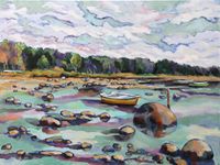
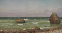
As Kakumäe bay coastline has various landscape settings starting with usual and flat sandy beach to high (32 m) cliff coast, then it is loved by painters. Painters find inspiration in wavy sea, rocky beach and cliff coast. Small and arched bay allows to enjoy the sight of long land and sea border in the horizon.
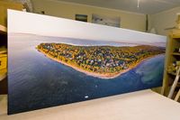
Professional and hobby-photographers also use Kakumäe bay as their worksite. Pink sunsets, capital city towers in yonder, ice forced to coast by waves in winter are all taken into photographs. Nowadays, as drone pictures are available quite easily, whole coastline as panorama picture is often presented in wall art.
Rocky beach in Kakumäe. Oil painting by Herlet Elvisto. 2015. Link: http://www.herlet.eu/kakumaumlemaal.html
On the Kakumäe peninsula. Painting by Jan Tammik. 2008. Link: http://www.e-kunstisalong.ee/?e=naitused&n=1&num=2861
Panoramic photograph of the Kakumäe peninsula on canvas by Kaupo Kalda. Link: http://minuprint.com/kakumae-panoraam/
A.2 Summary of you landscape system analysis and your development Targets
- You can summarize your findings with an DPSI(R) Model or a Spider Diagram
- Link back to the Sustainable Development Goals: Which goals are at risk?
- What is your hypothesis for this landscape?
- Visualise your hypothesis with one graphic/pict
- Are there any existing initiatives taking action in this landscape? Do you have a critical perspective on that?
- Add text and visuals
- Your case your spider diagram or dpsir model.jpg
explain your analysis briefly in the caption
- Your case your hypothesis visual.jpg
explain your hypthesis briefly in the caption
A.3 Theory reflection
- Reflect on at least three international policy documents in relation to their local landscape case
- choose one international, one European and one national document
- You can choose references from our reading list
- Scope: 250 words
A.4 References
- give a full list of the references you have used for this section
Phase B: Landscape Evaluation and Assessment
B.1 Assessment Strategy
- Based on the hypothesis derived from your previous landscape systems analysis you are now asked to define the goals for assessing the landscape. Your assessment is the basis for evaluating the landscape status.
- Which elements and phenomena need to be mapped, why and how?
- This a text contribution, max 250 words
B.2 Mapping
- As defined by your assessment strategy you conduct the mapping and present your findings here
- As a minimum, at least three different themes need to be mapped, you may choose more if needed
- Your case your assessment mapping themel.jpg
briefly explain the findings of your mapping
- Your case your assessment mapping theme2.jpg
briefly explain the findings of your mapping
- Your case your assessment mapping theme3.jpg
briefly explain the findings of your mapping
B.3 Problem definition and priority setting
- Give a summary of the major findings of your mapping process, what are the problems/potentials identified?
- Draw a problems/potentials map
- Set priorities for the most relevant issues
- Your case problems potentials map.jpg
add caption here
B.4 Theory reflection
- Please reflect the assessment and evaluation methods used based on at least three readings
- Did you encounter limitations'
- 200 words test contribution
B.5 References
- give a full list of the references you have used for this section
Phase C – Strategy and Master Plan
C.1 Goal Setting
- Define strategic planning objectives based on the evaluation findings
- Link back to your original targets from section one and the Development Goals
- 150 words text contribution
C.2 Spatial Strategy and Transect
- translate your strategic goals into a vision
- develop a spatial translation of your vision
- exemplify your vision in the form of a transect with concrete interventions
- add map(s) and visualizations
- Your case spatial translaton vision.jpg
add caption here
- Your case transect.jpg
add caption here
- Your case transect detail1.jpg
add caption here
- Your case transect detail2.jpg
add caption here
C.3 From Theory of Change to Implementation
- For implementing your vision: Which partnerships are needed? Which governance model is required?
- Who needs to act and how? Draw and explain a change/process model/timeline
- Which resources are needed? On which assets can you build?
- add 150 words text and visuals
- Your case spatial your governance model.jpg
add caption here
- Your case spatial your process model.jpg
add caption here
C.4 References
- give a full list of the references you have used for this section
1. Thematic plan of The Green Areas of Tallinn. 2005. Link: https://www.tallinn.ee/est/ehitus/g6479s42710
2. Environmental impact assessment strategy of Tallinn 2030. 2009. Link: https://www.tallinn.ee/est/g3566s49861
3. Rannamõisa landscape protection area. Estonian Nature Information System. Link: http://loodus.keskkonnainfo.ee/eelis/default.aspx?state=4;68547596;est;eelisand;;&comp=objresult=ala&obj_id=5265
4. Muraste landscape protection area. Estonian Nature Information System. Link: http://loodus.keskkonnainfo.ee/eelis/default.aspx?state=6;572247461;est;eelisand;;&comp=objresult=ala&obj_id=-1089849416
D. Process Reflection
- Reflect in your intercultural and interdisciplinary team on the outcomes of your study
- Which limitations were you facing?
- What have you learnt from each other?
- What would you do differently next time?
- You can also use diagrams/visuals
- 250 words text
![Photo taken by Silja Konsa in October 2013 [1]](/images/thumb/2/2c/Peeter-Suure-merekindlus-Suurupi-helgiheitja.jpg/200px-Peeter-Suure-merekindlus-Suurupi-helgiheitja.jpg)
![Caves of Tilgu in Rannamõisa landscape protection area. Photo taken by Ilme Parik in May 2014 [2]](/images/thumb/d/da/Tilgu_koobas.jpg/200px-Tilgu_koobas.jpg)


