Cliff Coast of Kakumäe Bay
>>>back to working groups overview
| Area | Cliff Coast of Kakumäe Bay | |
| Place | Haabersti, Tallinn | |
| Country | Estonia | |
| Topics | Cliff coast: Nature protection and suburbanisation near Tallinn | |
| Author(s) | Janne, Ibuki, Kadri, Kadi | |
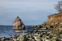
 Kakumäe sandcliff [1] Kakumäe sandcliff [1]
| ||
Rationale
- Why do you think this case is relevant? What is your hypothesis considering the landscape challenges?
- Format: 3-4 sentences
Kakumäe bay area is a suburbanisation near the capital city of Estonia. The coast is covered with several nature protection areas to conserve the limestone cliff of North-Estonia. Thus the state of this coastal area is at risk. Main challenge of this landscape is how to coexist with nature protection and dense urban area, which is constantly growing (biodiversity vs new development). It is important to ensure rich ecosystem and it's services to people.
Location and scope
You can edit this map with the map editor
A Landscape System Analysis
A.1 Landscape layers and their system context
Geomorphology, landscape units and coastal typology
- Description of evolution, status quo and driving forces, is the coastal typology changing? Why is that? (approx 200 signs)
- add 1-2 graphical representations to the image gallery, you can add more if you like
Kakumäe bay is part of Tallinn bay which is on the southern coast of the Gulf of Finland.
According to the coastal typology adopted for the EUROSION project, Kakumäe bay can be described as a combination of Hard rock coastal plains (Hard rock sandstone cliffs and limestone steps), Soft rock coasts (Moraine coastal bluffs) and Wave-dominated sediment, Plains (Silty, sandy, gravel, pebble and boulder beaches). Within these major coastal types several coastal formations and habitats occur, including bare sandy, gravel and pebble-boulder beaches, vegetated shores and windflats [2].
Recent geological history of this area is largely related to the isostatic uplift of the Earth’s crust in the northern part of the Baltic Sea region, which continues till now( 2mm annually in the Tallinn bay). Due to the uplift of the Earth’s crust, the coast and beaches are of emergent character [2].
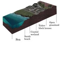
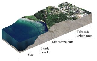
The coast within this area can be split into several morphologically different units, from west to east:
Tiskre: A flat coastal wetland is overgrown by bulrush and reeds. Fine sand and silt deposits cover the bare beach, which descends gradually to a very flat sandy foreshore forming atypical windflat. A wide-scale residential development is taking place in the backshore partly reclaiming the wetland.
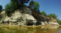
Kakumäe promontory: It is separated by Kakumäe bay and Kopli bay. The eroded hard rock sandstone cliffs and limestone steps occur in there. A steep up to 20 m high sandstone cliff overtopped by a thin layer of moraine till, is behind a narrow gravel-boulder beach. Also the foreshore profile is relatively steep. There is sandstone bedrock and erratic boulders with pebble from the bench [2].
-
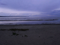 Tiskre: Flat sandy foreshore. 23. august 2011. Photo by Piret Kuub. Link: https://et.wikipedia.org/wiki/Kakum%C3%A4e_(Tallinn)#/media/File:Kakum%C3%A4e_rand.JPG
 -
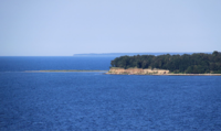 Kakumäe peninsula seen from Tabasalu cliff. 2 August 2010. Photo by Ingvar Pärnamäe. Link: https://en.wikipedia.org/wiki/Kakum%C3%A4e#/media/File:Kakum%C3%A4e_poolsaar.JPG
 -
 Street in Kakumäe. 16 September 2009. Photo by Jaanus Silla. Link: https://en.wikipedia.org/wiki/Kakum%C3%A4e#/media/File:Kakum%C3%A4e_Tallinn_Estonia.jpg


Land use
- settlements, infrastructure, agriculture, resource extraction, natural areas, energy production...
- description of evolution, status quo and driving forces, is the land use likely to change? Why is that? (approx 200 signs)
- add 1-2 graphical representations to the image gallery, you can add more if you like
According to CORINE land cover map, the case study area (within 5 km inland) can be described as a combination of
1) Inland marshes
2) Discontinuous urban fabric
3)Coniferous forest
4) Mixed forest
5)Pastures
6) Land principally occupied by agriculture, with significant areas of natural vegetation
7)Transitional woodland-shrub
8) Industrial or commercial units
The coast area ( within 2 km inland) is predominantly an urban area and coniferous forest.
In Tiskre and Kakumae, an extensive residential development of high standard is currently taking place at the coast in the suburban zone [2].
Waves erode the sandstone cliff in Kakumae. If the storm wave and surge action increases, the coming decades might witness a more intensive retreat of the shoreline and the cliff edge. Because of erosion impact, the new residential area is located next to the escarpment and might be eventually threatened if erosion increases. [3]
-
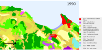 Land use transition from 1990 to 2012. CORINE land cover map. Link: https://land.copernicus.eu/pan-european/corine-land-cover
 -
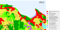 Land use transition from 1990 to 2012. CORINE land cover map. Link: https://land.copernicus.eu/pan-european/corine-land-cover


Green/blue infrastructure
- What are the major potential elements of a green/blue infrastructure network? Are these likely to change/disappear? Why is that?
- You find my background material on green infrastructure in our reading list
- add 1-2 graphical representations to the image gallery, you can add more if you like
Major potential elements of the green and blue infrastructure network of the cliff coast area are:
Green:
1) coastal forestpark
2) sand dunes with rose hips and other plants
3) cane grass
4) private gardens (living area consist mainly of private houses with gardens)
5) street trees & hedgerows
6) grasslands, pasturelands
7) Kakumäe bog
8)Landscape protection area of Rannamõisa
9) Landscape protection area of Muraste
10) Muraste bog
11) hiking trails (Tabasalu, Aura, Muraste)
Blue:
1) Kakumäe bay (part of Tallinn Bay)
2) Tiskre stream and its corridor
3) Harku lake
While Kakumäe is a suburbanization area situated in Tallinn, Harju County, which is one of the most densely populated counties in Estonia, there are still quite many green areas but the distribution of green network in that area is uneven. The uneven stationing is influenced by spatial planning and building actions of a growing city. New living areas are built in the expense of forest and coastal areas. [4]. According to the Environmental impact assessment strategy of Tallinn 2030, the reason lies in the lack of planned greenfields in residential areas not being constructed [5].
Biggest threat to the green network in Kakumäe area is the degradation of forest and coastal areas for building new development. Although the local government of Haabersti city part has taken for its vision to preserve and maintain the existing forest on the peninsula of Kakumäe as an enrichening element of the living environment [4]. In the thematic plan of The Green Areas of Tallinn this forest and coastal area is established as a conflict area, mainly because of the fear of the disconnection of green infrastructure network.
Other threat to coastal green areas is the weathering of rocks and soil from the cliff coast because of the waves of the sea, wind and other weather conditions. But also the growing number of people, who use the beach area for recreational purposes, needs to be regulated [5].
There are two landscape protection areas on the coastline: Rannamõisa and Muraste. Both of them are made for the protection of the limestone cliff and coastal forest in North-Estonia mainly to save them from development. Both of them are also stated as globally important protection areas and habitat places. [6] [7]. Rannamõisa landscape protection area is a habitat place for rare animal (Eptesicus nilssonii, Pipistrellus nathusii, Nyctalus noctula) and plant species (Orchis mascula, Cotoneaster niger) [6]. There are also Caves of Tilgu and outcrop of sandstone which both are under nature protection [8]. Muraste nature protection area is also made to protect other habitat types like gray dunes, limestone outcorp, old forests, swampy deciduous forest and scree forest.
-
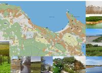 Green and blue infrastructure of Kakumäe Bay area. Numbers showing location. 1) cane grass 2) forest 3) sea & beach 4) Tiskre stream and its corridor 5) lake Harku 6) cliff 7 & 8) private gardens 9) street trees 10) grassland 11) hiking trail 12) Rannamõisa protection area 13) Muraste protection area 14) Muraste bog.
 -
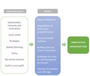 Factors influencing the green structure network and results that occure.
 -
 Northern bat (Eptesicus nilssonii) is considered into II protection category n Estonia. Link: https://en.wikipedia.org/wiki/Northern_bat
 -
 Dark-seed Cotoneaster (Cotoneaster niger) is under III protection category in Estonia. It is threatened by clear cutting the forest and building action. Link: https://et.wikipedia.org/wiki/Must_tuhkpuu
 -
 Caves of Tilgu in Rannamõisa landscape protection area. Photo taken by Ilme Parik in May 2014. Link: https://et.wikipedia.org/wiki/Tilgu_koopad#/media/File:Tilgu_koobas.jpg


Actors and stakeholders
- Who is driving changes in this landscape? Who is affected by those changes?
- Draw a stakeholder and/or power map: Who is affected highly but with low power? Who has high power but is not affected?
Kakumäe bay is a part of Harku municipality and Kakumäe peninsula is in Haabersti district. Harku municipality is a municipality located west of Tallinn, with a northern limit of 22 km in the Gulf of Finland. In Harku municipality the main charges are on the municipality governor. His main tasks are General Management, Municipality Representation, Planning and Building Co-ordination. The Haabersti District is a city authority in Tallinn, the aim of which is to ensure the provision of urban residents and businessmen in Haabersti district, the availability of public services and the development of the district, its hubs and settlements, and the functioning of the infrastructure, taking into account the needs and interests of the inhabitants of the district, as a whole of interest [chapter 1:1 [9]]
Kakumäe People's Society is a non-profit organization , whose goal is to improve and revitalize the living environment of the region.
In order to achieve its goals, the agency carries out the following activities:
1. Organizes joint activities of the members of the Society and public events related to the region;
2. Represents the interests of the members of the Society in all the activities concerning the region and actively contributes to the development of the region's living environment;
3. Interacts with local people, city authorities and other relevant parties
-
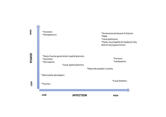 Powermap of Kakumäe coastal area showing different actors and stakeholders and their power and affection

Sacred spaces and heritage
- Which places/elements hold cultural value and to whom?
- You may add a map and some images, please also explain in your caption why these elements are valuable
On the left side of the shore of the Kakumäe bay, near Muraste protection area, there are naval fortresses of Peter the Great. Built between 1913-1917, they are now considered as cultural heritage objects of Estonia.
Peter the Great's naval fortress, also called the Tallinn-Porkkala defence station was a Russian fortification line, which aimed to block access for the Russian capital Saint Petersburg via the sea. The plans for the fortress included heavy coastal artillery pieces along the northern and southern shores of the Gulf of Finland. The emphasis was put on the defences of the gulf's narrowest point, between Porkkala (in Finland) and Tallinn (in Estonia). This was a strategic point, as the two fortresses of Mäkiluoto and Naissaar were only 36 kilometres apart. The coastal artillery had a range of about 25 kilometres and could thus "close" the gap between the shores, trapping enemy ships in a crossfire [10].
Near the left side of the coast, not far from the naval fortress, there are also ancient fields with findings of cultural layer. There are preserved stonebeds and stoneheaps of the ancient fields [11]. As remains of ancient settlement areas, there are also stone graves near the fields.
In addition to the named protected areas there are few objects outside the borders of protected areas – boulder of Black Stone in the top of Kakumäe peninsula, boulder of Tari between Rannamõisa and Ilmandu and smaller areas of plant species protection.
-
 Photo taken by Silja Konsa in October 2013. Link: https://register.muinas.ee/public.php?menuID=monument&action=imagegallery&id=8871
 -
 Boulder of Black Stone in the top of Kakumäe peninsula. Photo taken by Aime Pae in April 2008. Link: https://et.wikipedia.org/wiki/Fail:Kakum%C3%A4e_Mustkivi_Tallinnas.JPG


Visual appearance and landscape narrative
- Which elements are essential for the landscape character?
- Has the landscape been painted or otherwise depicted, when and whom? Which elements are essential?
- Which narratives exist? Who has written about this landscape or depicted it in some way?
- You can add text and images
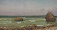
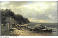
As Kakumäe bay coastline has various landscape settings starting with usual and flat sandy beach to high (32 m) cliff coast, then it is loved by painters. Painters find inspiration in wavy sea, rocky beach and cliff coast. Small and arched bay allows to enjoy the sight of long land and sea border in the horizon.
Eugen Gustav Dücker has depicted "Tiskre coast" in 1866, where fishing boats have arrived from sea. The painting is exhibited in Estonian National Art Museum. Herlet Elvisto has depicted in 2015 also simple boat on rocky coast. Jan Tammik painted in 2008 a boulder of Black Stone in the top on Kakumäe peninsula.
Professional and hobby-photographers also use Kakumäe bay as their worksite. Pink sunsets, capital city towers in yonder, ice forced to coast by waves in winter are all taken into photographs. Nowadays, as drone pictures are available quite easily, whole coastline as panorama picture is often presented in wall art.
-
 Rocky beach in Kakumäe. Oil painting by Herlet Elvisto. 2015. Link: http://www.herlet.eu/kakumaumlemaal.html
 -
 On the Kakumäe peninsula. Painting by Jan Tammik. 2008. Link: http://www.e-kunstisalong.ee/?e=naitused&n=1&num=2861
 -
 Painting by Eugen Gustav Dücker. Tiskre coast. Reference: A. Eilart, A. Kokk. 2012. Pintsliga tõmmatud Eesti. Lk 247
 -
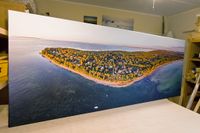 Panoramic photograph of the Kakumäe peninsula on canvas by Kaupo Kalda. Link: http://minuprint.com/kakumae-panoraam/


A.2 Summary of your landscape system analysis and your development Targets
- You can summarize your findings with an DPSI(R) Model or a Spider Diagram
- Link back to the Sustainable Development Goals: Which goals are at risk?
- What is your hypothesis for this landscape?
- Visualise your hypothesis with one graphic/pict
- Are there any existing initiatives taking action in this landscape? Do you have a critical perspective on that?
- Add text and visuals
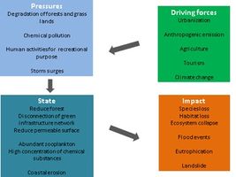
Summary of DPSI(R) model
Driving forces: We define five elements as driving forces such like urbanization (Dense settlement), anthropogenic emission (salinity), agriculture, tourism and climate change.
Pressures: Each Driving forces make pressures. Urbanization promotes degradation of forest and grasslands. If salinity and agricultures are not properly treated, nitrate pollution or chemical pollution will happen. Because of climate change, storm surges occur more frequently. If tourism of this place becomes popular, human activities for recreational purpose will increase.
State: Degradation of forest and grasslands means not only reducing the areas but also disconnection of green infrastructure network. It reduces permeable surface and there are more urban surface. Storm surges causes coastal erosion. Kakumäe area is the region where the most intense coastal erosion occurs in the City of Tallinn [12]. Also the erosion is predominant on the top of peninsulas. Chemical pollution is high concentration of some specific substances in water. In Tallinn bay, phosphate levels is relatively high [13]. It also connects abundant zooplankton. In the shallow area (depth about 10 m) of the Tallinn Bay, the population peaks of all major zooplankton groups were observed [13].
-
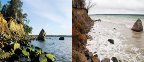 The erosion of the Kakumae Cliff in Tallinn City area. The boulder located at the shoreline in 1998 (left). Nowadays the shoreline is retreated about 8 m from the boulder (right). Photos: Tonis Saadre, Sten Suuroja. Link: http://www.syke.fi/download/noname/%7B0B13DA3A-C175-4AE7-A31C-FF621BA5917A%7D/130987.

Impact: Depletion of green infrastructure causes species loss, habitat loss and ecosystem collapse. Reduce permeable surface cause risk of flood especially when heavy rainfall happens. According to XGIS by Estonian land board, Tiskre living area is in danger of flooding along river side and estuary. Geological hazards here are mainly related to coastal erosion and landslides [13].
-
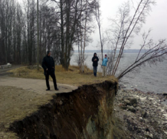 Less than 10 m left until the edge of the 9-meter-high cliff reaches to Kakumäe Peninsula, Tallinn. Link: http://www.borenv.net/BER/pdfs/ber12/ber12-653.pdf.

Sustainable Development Goals at risk
Goal 11: Make cities inclusive, safe, resilient and sustainable
Making cities inclusive, safe, resilient and sustainable is at risk because cities need to grow, but they need to do it while improving resource use and reducing pollution and poverty. In coastal areas the fear is that soon the whole area will be built up and there will be no public areas around the coastal regions and forest felling.
Goal 14: Conserve and sustainably use the oceans, seas and marine resources Ocean currents make life on Earth possible, by run global systems. Many things are provided to us by the sea. Estonians are the people of the sea, because the territory of Estonia is flanked by the sea on both sides. And when we lose the possibility to get to the sea the entire cultural heritage will lose its importance.
Goal 15: Sustainably manage forests, combat desertification, halt and reverse land degradation, halt biodiversity loss
Forests cover 51% of Estonia’s surface and in addition to providing food and shelter for animals they are also key to combating climate change. Deforestation and desertification – caused by human activities and climate change – pose major challenges to sustainable development and have affected the lives and livelihoods of millions of people in the fight against poverty. Efforts are being made to manage forests and combat desertification. Desertification is not a big problem in Estonia, but when things keep happening the way the earth is becoming warmer it could become a problem.
Hypothesis for the landscape
As we analysed settlement development in Kakumäe bay area, and it is clearly noticeable that settlement area has increased rapidly. Pressure for new residential areas on the beautiful coast is severe. Mostly there are plots of individual houses, some areas for apartment buildings. Traffic density in main roads has increased and resulting with jams near Tallinn. Collective roads are rather narrow. Many parks, which where kept as parts on green infrastructure, have been built up to residential areas.
Keeping construction away from parks and arable land is more and more challenging. Beside nature protection areas and endangered species habitats, there are only some forest plots remained near the coast.
-
 Settlement areas have increased rapidly and it is more challenging to keep away from building at the expense of parks and arable land.

The perspective on existing initiatives taking action in the landscape now is rather critical. Mainly because of the age of the strategic documents, like County plan of Harjumaa, The Thematic plan of The Green Areas of Tallinn, Strategic environmental impact assessment of the comprehensive plan of Haabersti city district which are all over 10 years old. The stated goals there are indeed important, eg broadening the building prohibition zone of a transmission line area, which also helps to save greenery and plantation is also helping to avoid erosion. But they are also stating the fact that if trees are too close the the edge of the cliff, it may fall quicker. Therefore they acknowledge that this is only one part to prevent it but the overall solution has to be more broader and complex.
Positive thing is that Haabersti city district has a special thematic map made in 2016, where areas in danger of erosion, cliff weathering and flooding are brought out. They are mainly located on the peninsula of Kakumäe. Tiskre living area is in danger of flooding.
-
 DPSI(R) model showing driving forces (urbanization), pressures (degradation of forest/ grasslands), state of situation (degradation of forest leads to disconnection of green infrastructure) and impact (species/ habitat loss.
_MODEL.jpg)
A.3 Theory reflection
- Reflect on at least three international policy documents in relation to their local landscape case
- choose one international, one European and one national document
- You can choose references from our reading list
- Scope: 250 words
International policy document:
Sustainable development goals
On September 25th 2015, countries adopted a set of goals to end poverty, protect the planet and ensure prosperity for all as part of a new sustainable development agenda. Each goal has specific targets to be achieved over the next 15 years. Countries adopted the 17 Sustainable Development Goals. In 2016, the Paris Agreement on climate change entered into force, addressing the need to limit the rise of global temperatures. The 17 goals are No Poverty, Zero Hunger, Good Health and Well-being, Quality Education, Gender Equality, Clean Water and Sanitation, Affordable and Clean Energy, Decent Work and Economic Growth, Industry, Innovation and Infrastructure, Reduced Inequality, Sustainable Cities and Communities, Responsible Consumption and Production, Climate Action,: Life Below Water, Life on Land, Peace and Justice Strong Institutions, Partnerships to achieve the Goal. The objective of sustainable development is to achieve a balance between the social, economic and environmental spheres and to ensure a full-fledged social life for present and future generations.
European policy document:
The European Landscape Convention
According to the Landscape Convention, the most radically affected areas by change (economic, social, environmental) are peri-urban and coastal areas (Kakumäe being both). Therefore it is important to raise awarness of landscape policy [14]. Estonia joined the convention in last December (20.12.2017). Through this convention the awarness of landscape values among society, organisation and authorities rises. Countries that have joined are asked to evaluate their landscapes, analyse them and the transforming forces and influences, and monitor the changes in landscapes [15].
National policy document:
Harju County Plan 2030
In Harju county-wide spatial plan of 2030 there is admitted that according to green network Harju county in most complex. Environment is strongly influenced by growing human settlement and infrastructure. Comparing with previous same level plan, which was composed in 2003, large areas of green network have been replaced with new human settlement areas near Tallinn. 2030 plan also admits that the plan of 2003 had a proposal to start preserving city forests to maintain green belt around Tallinn, but action towards this goal has not been made [16].
In 2030 plan settlement-directing map whole Kakumäe bay coastal area is marked as a compact settlement area. At the same time west-coast of Kakumae bay is still marked as valuable landscape. Green network, which was determined on east coast of Kakumäe bay in 2003 planning, is now human settlement area [4].
A.4 References
1. Kakumäe. Tallinn. Wikipedia. Link: https://et.wikipedia.org/wiki/Kakum%C3%A4e_(Tallinn)
2. EUROSION Case Study: Tallinn (Estonia). 2002. Link: http://copranet.projects.eucc-d.de/files/000112_EUROSION_Tallinn.pdf
3. Coastal erosion and protection in Europe.(2013) Tõnisson,H., Orviku, K., Lapinskis, J., et al. Pages 47-80. Link: http://www.peconsulting.se/wp-content/uploads/2013/05/TLC-materialIETU.pdf
4. Thematic plan of The Green Areas of Tallinn. 2005. Link: https://www.tallinn.ee/est/ehitus/g6479s42710
5. Environmental impact assessment strategy of Tallinn 2030. 2009. Link: https://www.tallinn.ee/est/g3566s49861
6. Rannamõisa landscape protection area. Estonian Nature Information System. Link: http://loodus.keskkonnainfo.ee/eelis/default.aspx?state=4;68547596;est;eelisand;;&comp=objresult=ala&obj_id=5265
7. Muraste landscape protection area. Estonian Nature Information System. Link: http://loodus.keskkonnainfo.ee/eelis/default.aspx?state=6;572247461;est;eelisand;;&comp=objresult=ala&obj_id=-1089849416
8. Caves of Tilgu. Wikipedia. Link: https://et.wikipedia.org/wiki/Tilgu_koopad
9. Haabersti Linnaosa Valitsuse põhimäärus, chapter 1, § 1. Link: https://www.riigiteataja.ee/akt/427062014029
10. Peter the Great's Naval Fortress. Wikipedia. Link: https://en.wikipedia.org/wiki/Peter_the_Great%27s_Naval_Fortress
11. Ancient fields. National Registry of Cultural Monuments. Link: https://register.muinas.ee/public.php?menuID=monument&action=view&id=17470
12. Valdmann. A., Käärd. A., Kelpšaitė. L., Kurennoy. D., Soomere. T. (2008). Marine coastal hazards for the eastern coasts of the Baltic Sea- Baltica. 21:1-2. Link: http://citeseerx.ist.psu.edu/viewdoc/download?doi=10.1.1.503.4950&rep=rep1&type=pdf
13. From small scales to large scales–The Gulf of Finland Science Days 2017. Estonian Academy of Sciences. Tallinn. Link: http://www.syke.fi/download/noname/%7B0B13DA3A-C175-4AE7-A31C-FF621BA5917A%7D/130987
14. Council of Europe: The European Landscape Convention (Florence, 2000). Link: https://www.coe.int/en/web/landscape/the-european-landscape-convention
15. Landscape Convention. Ministry of the environment. Republic of Estonia. Link: http://www.envir.ee/et/euroopa-maastikukonventsioon
16. Harju county-wide spatial plan 2030+. Hendrikson&Ko. Harju maavalitsus. link: http://www.maavalitsus.ee/documents/2845826/19256713/Seletuskiri+-+Harju+maakonnaplaneering+2030-.pdf/c23d2594-f172-4927-b98d-ae0591436ebb
Phase B: Landscape Evaluation and Assessment
B.1 Assessment Strategy
- Based on the hypothesis derived from your previous landscape systems analysis you are now asked to define the goals for assessing the landscape. Your assessment is the basis for evaluating the landscape status.
- Which elements and phenomena need to be mapped, why and how?
- This a text contribution, max 250 words
Based on the evaluation of the Kakumäe landscape area, we can see that if the real estate development pressure will continue the way it does now, the future situation will be that Kakumäe area will be very densely populated. The houses would have to be built at the expense of forest and grassland areas as they already are now. When looking at the strengths of Kakumäe Bay area, there are many connected to the nature: rich nature and diversity of green areas (forest, beach, grassland, reed area), uniqueness (coastline, limestone cliff and peninsula), biodiversity (landscape protection areas), closeness to sea (scenic views and also the physical closeness), possibility for gardening and crowing some crops. The whole coast area is also brought out in the Green network plan of both Harku and Tallinn as important areas for the movement of animals and substances. Therefore, the most important goal is to keep the area from over building and balancing the green areas and development areas. Second important thing is to enhance the ecosystem goods and services through green network planning. Ecosystem services are important part of a well-functioning society and environment, and also protect the functioning green infrastructure, because it helps to provide fresh air, clean water, promote societal wellbeing, health and other ecosystem services.
Based on the previous information and analysis, it is important to map the following elements:
1) Landscape character areas to see the real diversity of the current situation.
2) urban sprawl to see how much the settlement has grown since nineties to today. This can be done by analysing online maps from Maa-amet.
3) access to the sea (both visual and physical) to see the barriers of nature but also the ones coming from development. This can be based on the online maps and photos collected during the fieldtrip.
B.2 Mapping
- As defined by your assessment strategy you conduct the mapping and present your findings here
- As a minimum, at least three different themes need to be mapped, you may choose more if needed
Landscape Character Assessments and Coastal Character Assessment
We found out Kakumäe bay area has various landscape and its layers therefore we start assessment based on Scotland’s Landscape Character Assessments (LCA) and Coastal Character Assessment (CCA).
LCA (10 units) ①Detached house ②Commercial area ③Manufacture factory area ④Protected forest ⑤Mix forest without protection ⑥Conifer forest ⑦Shrub with cultural heritage ⑧Forest with cultural heritage ⑨Open grassland ⑩Irrigated pastures
CCA (6 units) ⑪Bare sandy beach ⑫Gravel and pebble-boulder beach ⑬Coastal wetland ⑭Estuary ⑮Sandbank ⑯Limestone cliff
Kakumäe bay and its coastal area offer a wide range of different landscapes. The main land cover is open grassland which is mown seasonally. There are similar land characteristic, irrigated pastures and shrubs with cultural heritage layer which have archaeological and cultural importance. Also there is a conifer forest as one of the main Estonian forest types, which could be interesting as a special habitat but also for berry and mushroom picking. Coastal area offers various cultural activities. Limestone cliff has many viewpoints, which offer a significant coastal wide view of Kakumäe bay, peninsula, and Baltic Sea. In bare sandy beach people can enjoy marine leisure such as fishing, sailing, kitesurfing, kayaking and paddle boarding.
-
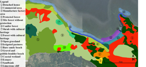 LCA and CCA landscape areas

Urban sprawl
Coastline area is a very picturesque and unique landscape, closeness to sea invites developers and residents. That leads to major development pressure. Over the years residential areas have expanded considerably. New residential areas are mostly in 1 km wide shoreline and green network area in Tallinn is covered with residential plots. Expansion widens to outskirts of Tallinn. Development is done mostly by conducting detailed planning and large areas are planned at once with roads and communications. Estonian Nature Protection Law stipulates building prohibition zone at the sea coast to 100 m, in case of Baltic Sea even 200 m. In Kakumäe bay area the zone has been reduced to 50 m. Some buildings are still closer to the sea than 50 m.
In Harju county-wide spatial planning, which is valid until 2030, in Tallinn city borders and along coastline green network is overlapped with area, which is suitable for compact settlement. So the planning is just reconciling the urban sprawl. In Harku comprehensive plan green areas have expanded a bit and some new green corridor areas have been set.
In thematic plans, where green network areas have been defined, it is stated that main green network areas, which are not situated in protected areas, natural area percentage should not be under 90%. In addition, it is important that the distance between the gardens or the plots is at least 500 m in order to provide nesting conditions and habitats to bird and animal species. Some of green network areas shown in mappings are also defined as main and important areas in green area theme planning. Still, they are 100% built and nowadays gardening with 5 cm lawn does not improve biodiversity.
Also in 2018 mapping we have brought out flooding density which is predicted to happen once in 50 years. Many houses will be in flooding area if that occurs.
-
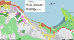 Situation in 1995. In the mapping red line is border of Tallinn, light green represents green network, dark green areas there endangered species can be found, pink cultural heritage areas, dark blue flooded area, where flooding is predicted to happen once in 10 years. Yellow area is there residential buildings have been built.
 -
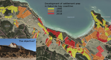
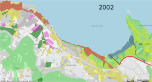 From the map of 2002, you can see that residential area has expanded substantially with periods of time, especially on the peninsula, in Tiskre and Rannamõisa area.
 -
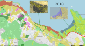 Condition of the current situation in 2018. One good example near Rannamõisa (shown on the upper left photo), how to develop residential plots as it could be done in green network area. Plot location and sizes (marked yellow on the photo) are done maintaining green structure and sizes are not very big and located sparsely, leaving room for plants to exist and animals to inhabit.


Accessibility to the sea and coast area
Near the residential area good access to the the sea is mostly for the people who live there. Except the beach area. Kakumäe beach is a public beach with a park area accessible to all tourists and locals. It is rather a quiet place where foreigners don't find the way because there are more popular and bigger ones closer to Tallinn. Forest trails near the coast are used mostly by dog walkers and people who just want to spend time in the nature (recreational purpose). For people, who want to relax and spend a quiet time away from all the big town noise, is the area perfect. On the cliff there are no barriers. The accessibility to the sea is good at the lower part and the sea water is clear but with some bigger rocks. In Tiskre area there is a huge area of reed where the access to water for people is difficult, almost impossible. The reed is also a visual barrier because the view to the sea is not available from the ground level, meaning people walking on the hiking trail will not see the sea (private house owners can see from their second floor).
-
 Map showing the different accesses on Kakumäe coastal area

B.3 Problem definition and priority setting
- Give a summary of the major findings of your mapping process, what are the problems/potentials identified?
- Draw a problems/potentials map
- Set priorities for the most relevant issues
Through LCA and CCA mapping process, we found out detached houses divide conifer forest into small patches especially in peninsula and Paekalda area. It brings an issue of concern to habitat fragmentation, wherein those detached houses and resident’s activity split up habitat areas, causing animals to lose both their natural habitat and the ability to move between patches. To mitigate the ecosystem decay, we think establishing wildlife corridor is important for the development of the areas, for example, building ecosystem garden for each house or establishing Biotope Park. Those mitigation measures could reduce and compensate significant negative impact for biodiversity. To focus on pattern and shape of development, detached house disperse in open grassland as small patches (Ilmandu area). In the future, it might cause leap frog development, which would demolish landscape and nature habitat in this area. For developers, the most suitable area for building would be continuing it in Muraste residential area, not as a dispersion in the middle of the grassland.
Our prediction for the future based on the data from urban sprawl mapping is the continuing of urban sprawl. As 1 km wide coastline is already built up, then sprawl continues to fields on the other side of the main road. For main services, like jobs, schools, kindergartens and entertainment, they mostly still use benefits of Tallinn. That will also cause even more dense traffic. Local municipalities have to consider the fact that if the number of residents is growing, the number of recreational areas, like parks, forests, playgrounds, and other essential needs, like kindergarten, shops, etc, have to grow also, because otherwise the needs for the residents will not be fulfilled for the area to function correctly.
-
 We brought out the problems in Kakumäe area but also the potentials with what to soften the negative influence.

B.4 Theory reflection
- Please reflect the assessment and evaluation methods used based on at least three readings
- Did you encounter limitations'
- 200 words test contribution
To read and understand the complex and diverse Kakumäe area even more, we chose Landscape Character Assessment (LCA) and Coastal Character Assessment (CCA) for our assessment and evaluation methods. Those methods are based on not only geographical understanding but also the visual and experiential aspects therefore it helps us for comprehending the process of landscape forming and the pressures for change. Through our LCA and CCA, it turns out development of detached houses (Stand-alone houses) is the most dominant and significant impact in Kakumae area. Also its various coastal landscape (Bare sandy beach, gravel and pebble-boulder beach, coastal wetland, limestone cliff etc..) provides diverse ecosystem services but at the same time, it has high sensitivity and low capacity for the impact.
We were also using the SWOT method to assess the strenghts and weakness of the Kakumäe area. This also lead to establishing problems and solutions.
The impacts of urban sprawl according to EEA Report “Urban sprawl in Europe. The ignored challenge”
Natural and protected areas The impacts of sprawl on natural areas are significant. Land sustains a number of ecosystems functions including the production of food, habitat for natural species, recreation, water retention and storage that are interconnected with adjacent land uses. The considerable impact of urban sprawl on natural and protected areas is exacerbated by the increased proximity and accessibility of urban activities to natural areas, imposing stress on ecosystems and species through noise and air pollution.
The environmental impacts of sprawl are evident in a number of ecologically sensitive areas located in coastal zones and mountain areas. Along the European coastal regions urban sprawl is endemic. The development related impacts on coastal ecosystems, and their habitats and services, have produced major changes in these coastal zones.
Rural environments The growth of European cities in recent years has primarily occurred on former agricultural land. Urban development and agriculture are competing for the same land, as agricultural lands adjacent to existing urban areas are also ideal for urban expansion.
Soils are non renewable resources and the loss of agricultural land has major impacts on biodiversity with the loss of valuable biotopes for many animals, and particularly birds. Sprawling cities also threaten to consume the best agricultural lands, displacing agricultural activity to both less productive areas and more remote upland locations.
Urban quality of life, hazards and health Sprawl related growth of urban transport and greenhouse gas emissions have major implications for global warming and climate change, with the expectation of increasingly severe weather events in the coming years and increased incidences of river and coastal flooding.
Socio-economic impacts From a social perspective urban sprawl generates greater segregation of residential development according to income. The socio economic character of suburban and peripheral areas is typified by middle and upper income families with children, who have the necessary mobility and lifestyle to enable them to function effectively in these localities.
B.5 References
- give a full list of the references you have used for this section
1. Study of green network core areas and corridors in Harku municipality. 2007. Link: http://www.harku.ee/documents/2846103/2951007/seletuskiri+%281%29.pdf/3372b6d5-56b3-41b8-9588-550aca9339b5
2. Maa-amet. Online map server. Link: http://xgis.maaamet.ee/xGIS/XGis
3. Comprehensive plan of Harku municipality. Link: http://www.harku.ee/kehtiv-uldplaneering.
4. Landscape Character Assessment guidance for England and Scotland. Link: https://www.nature.scot/sites/default/files/2018-02/Publication%202002%20-%20Landscape%20Character%20Assessment%20guidance%20for%20England%20and%20Scotland.pdf
5. Scottish Natural Heritage. Guidance note. Coastal Character Assessment. 2017. Link: https://www.nature.scot/sites/default/files/2018-02/Guidance%20Note%20-%20Coastal%20Character%20Assessment.pdf
Phase C – Strategy and Master Plan
C.1 Goal Setting
- Define strategic planning objectives based on the evaluation findings
- Link back to your original targets from section one and the Development Goals
- 150 words text contribution
From the evaluation results and analysis main goals were stated to be achieved. The main goals are determining urban area (stop urbanization), enhancing green corridor concept, improving access to coastal areas, powering the stakeholders.
For the first goal to stop urbanization we need to border housing development areas and define green areas. For mitigating urbanization outcomes we need to plan social areas, jobs close to home, promote self-employment and small business initiatives and improve public transportation and plan traffic infrastructure according to local needs. Building restrictions must be permanent and fixed, we need to follow the rules and only build where it is allowed. This goal is linked with the development goal 11 ” Make cities inclusive, safe, resilient and sustainable”, because cities need to grow, but they need to do it while improving resource use and reducing pollution and poverty. In coastal areas the fear is that soon the whole area will be built up and there will be no public areas around the coastal regions and forest felling.
For the second goal of enhancing green corridor concept we need to promote knowledge about ecological gardens as part of green areas or corridors and educate people about it. From the development goals it is linked with goal 15 „Sustainably manage forests, combat desertification, halt and reverse land degradation, halt biodiversity loss“, because forests cover 51% of Estonia’s surface and in addition to providing food and shelter for animals they are also key to combating climate change. Deforestation and desertification – caused by human activities and climate change – pose major challenges to sustainable development and have affected the lives and livelihoods of millions of people in the fight against poverty.
For the third goal of improving access to the coastal areas we would need to improve safety, facility for recreation, view platforms and add staircases to access the water. The coastline is very different in all parts, from rocky to full of reed. It is linked to development goal 14 „Conserve and sustainably use the oceans, seas and marine resources“, because Estonians are the people of the sea, the territory of Estonia is flanked by the sea on both sides. And when we lose the possibility to get to the sea the entire cultural heritage will be damaged.
For the fourth goal of powering stakeholders we mean the initiative from people and considering their values. From the development goals it is linked to goal 17 „Revitalize the global partnership for sustainable development“. Successful sustainable development agenda requires partnerships between governments, the private sector and civil society. These inclusive partnerships built upon principles and values, a shared vision, and shared goals that place people and the planet at the center, are needed at the global, regional, national and local level.
C.2 Spatial Strategy and Transect
- translate your strategic goals into a vision
- develop a spatial translation of your vision
- exemplify your vision in the form of a transect with concrete interventions
- add map(s) and visualizations
Spatial translation vision
GOAL: Balance between urban development and nature protection
VISION: Kakumäe coast is comprehensive living area, which offers multi-purpose green surrounding and good social infrastructure
MAIN OBJECTIVES: Determining urban area (stop urbanization), enhancing green corridor concept, improve equal and safe access to coastal areas and powering stakeholders to encourage communication
We need to stop urbanization in Kakumäe bay area to keep good living conditions for people who already live there and protect remaining green areas. Green areas are bordering exisiting living areas and provide people with shelter, natural balance and recreational opportunities.
In mapping of green corridors there are pointed out excisting and potential corridors. Existing green corridors mostly connects existing protected natural and cultural areas, or are situated in places where nature conditions are not suitable or easy for construction. We suggest that corridors should be as wide as possible so that they would provide habitats for different animal and plant species and allow undisturbed movement from one area to another.
As demand for new living areas in Kakumäe bay area will not vanish overnight, we suggest to set conditions according to which housing development is allowed. For example: plot size minimum (4000 m2), fenced area of the whole plot (20%), most of the plot has to be maintained as forest or meadow, different vegetation fronts have to be used (and other ecological garden ideas should be implemented).
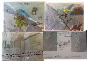
Improving access to the sea
Our transects are made from different places starting from sea. Kakumäe bay coastline contains various coast types represented in Estonia – limestone cliff, stony beach, sandy beach and beach, which is overgrown by vegetation (reed). In our case we have to separate two different ways of access to the sea – visual (you can see the sea but can not touch) and physical (you can touch the water).
In our acupuncture design we concentrated on enhancing both – visual and physical access to the sea. We tried to connect whole coastline so that places where you can only see the sea but can not touch would not be too far from places where you can physically put your toes in water. For joining those areas we added staircase onto the cliff and bridge over the Tiskre stream to connect different coast types. For improving visual access we suggest view platform onto the cliff and boardwalk in the reed/flooded area.
-
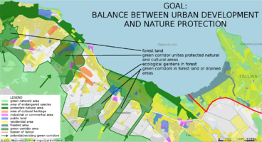 Illustrational map of our spatial strategy and goal
 -
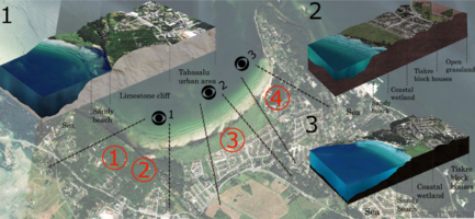 Transect locations in Kakumäe coastal area
 -
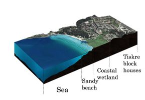 Transect of sea, beach and living area.
 -
 Transect of the sea, reed and Tiskre living area
 -
 Transect of the sea, cliff and Tabasalu living area
 -
 Urban accupuncture design details on the transect areas


C.3 From Theory of Change to Implementation
- For implementing your vision: Which partnerships are needed? Which governance model is required?
- Who needs to act and how? Draw and explain a change/process model/timeline
- Which resources are needed? On which assets can you build?
- add 150 words text and visuals
We are not purposing big changes or design solutions, rather enhancing the situation by not letting it to become worse. All the major principles are set already in the strategic documents, now it’s just time to apply them and try new implementing techniques (eg workshops that raise awareness of ecological gardens for inhabitants so their interest grows).
Estonian planning system is hierarchical. The Natura 2000 network and Habitat Directive (EU’s legislations) are the frameworks that Estonian government has to implement on national level. Such projects create a network of protected areas and other landscape structures. There is also the European Green infrastructure strategy and other documents. Comprehensive plans are made by municipalities separately and are focused on implementing these frameworks/strategies and ensure the connectivity of habitats on the landscape level. Government driven initiatives of the municipalities are different and therefore in many cases green areas established on the strategic documents and comprehensive plans stay on paper and are not implemented in real situation. There is no use of good written manuals and plans if nobody is willing to really use them.
There is a lack of supervision of the actions and following of the strategic documents by the municipalities and local government institutions. But by adopting wider stakeholder participation and consultation processes (local inhabitants, Kakumäe People’s Society, real estate developers etc), the development of the implementation of the planning documents and strategies can be encouraged. The green infrastructure and ecosystem services have to be taken into account in policy-making on all governance levels, especially in spatial planning.
-
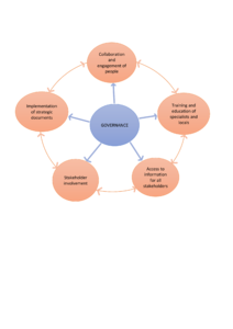 Governance model for accomplishing our stated vision.
 -
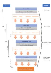 The ideal model of strategic planning and how to achieve the goals in Kakumäe coastal area.
 -
 Goal tree illustrating how to implement our vision.


![[1]](https://et.wikipedia.org/wiki/Kakum%C3%A4e_(Tallinn)#/media/File:Kakum%C3%A4e_liivakivipank_Tallinnas.JPG)
#/media/File:Kakum%C3%A4e_rand.JPG)
C.4 References
1. Design, implementation and cost elements of Green Infrastructure projects. Final report to the European Commission. 2011. Naumann, Sandra, McKenna Davis, Timo Kaphengst, Mav Pieterse and Matt Rayment. Ecologic institute and GHK Consulting.
2. Sustainable Development Goals. 17 goals to transform our world. United Nations. Link: https://www.un.org/sustainabledevelopment/sustainable-development-goals/.
D. Process Reflection
- Reflect in your intercultural and interdisciplinary team on the outcomes of your study
- Which limitations were you facing?
- What have you learnt from each other?
- What would you do differently next time?
- You can also use diagrams/visuals
- 250 words text
The overall process of this course has been very interesting and complex, but most of all very educating. The structure of the course has been very good, all of the materials and lectures helped to accomplish the final result. Our team was very motivated through the whole process even though it was sometimes difficult to meet with each other. The inbetween presentations were also helpful for the final outcome and the tutors were very supporting.
One of the limitations for our group was the distance, complexity and scope of the studyarea. The second limitation was difficulty of meeting each other. Despite everybody is from the same school and course, it was difficult to find time to sit together and go to consultations. We still managed to work very efficiently online.
Next time we would meet and discuss face to face more.