Case Study A.2: Pozzuoli-Solfatara-Astroni: Difference between revisions
Undo revision 6252 by Geanina.fanaru (talk) |
|||
| Line 114: | Line 114: | ||
=== Visual appearance and landscape narrative === | === Visual appearance and landscape narrative === | ||
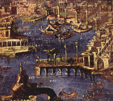
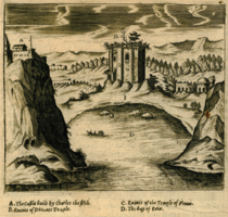
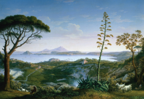
First dated fresco - 1st century - reflecting the nature of our study area is to be found in Stabiae, in Magna Graecia region overlooking the Gulf of Napels. Which is shaped by the eruption of M. Vesuvius in 79 AD. The drawing of "Gulff Baiae near Pozzuoli, represents the built structure to be found along the costal area, the building represents the Aragonese Castle and a a Roman bath, which used to be mistaken for temple of Venus. A landscape painter from Brandenburg, whos works were mostly done in Italy, drew the Gulf of Pozzuoli from Solfatara. Solfatara is a shallow volcanic crater forming a part of the Phlegraean Fileds. | |||
The 20 years old young Januarius became the bishop of and later the patron saint of Naples, this iconic character shown in a copy of the lost original by Michelangelo Merisi da Caravaggio. The Procession de saint Janvier a Naples painting by Antoine Jean Baptiste Thomas reflects the dominance and the tragedy of the volcanic eruption in 79 AD. | The 20 years old young Januarius became the bishop of and later the patron saint of Naples, this iconic character shown in a copy of the lost original by Michelangelo Merisi da Caravaggio. The Procession de saint Janvier a Naples painting by Antoine Jean Baptiste Thomas reflects the dominance and the tragedy of the volcanic eruption in 79 AD. | ||
| Line 122: | Line 122: | ||
Furthermore it has been mentioned its history that Sulla, the Roman Dictator owned a country villa in the region, the apostle Paul landed here on his way to Rome... | Furthermore it has been mentioned its history that Sulla, the Roman Dictator owned a country villa in the region, the apostle Paul landed here on his way to Rome... | ||
From all these different types of documentations since the time of Roman Empire, we can tell that this charismatic and inspirational piece of landscape is important in both natural and anthropogenic histories of the region. | From all these different types of documentations since the time of Roman Empire, we can tell that this charismatic and inspirational piece of landscape is important in both natural and anthropogenic histories of the region. | ||
<gallery caption=" " widths="200px" heights="150px" perrow="5"> | <gallery caption=" " widths="200px" heights="150px" perrow="5"> | ||
Revision as of 00:40, 5 April 2019
>>>back to working groups overview
| Area | Workgroup Naples 2A: Pozzuoli-Solfatara-Astroni | |
| Place | Naples | |
| Country | Italy | |
| Topics | Coastal Line Study, Understanding Coastal Landscapes, Evaluation and Assessment for Coastal Landscapes Integrated Planning and Design for Costal Landscapes | |
| Author(s) | Cristina Irimia, Ioana Anutoiu, Fanaru Geanina, Valentina Pignata, Vicenzo Sasso, Sin Yee Ho, Ivan Voskian | |

| ||
Rationale
The visual key of the area under study can be represented by the Carte del golfe di Pouzzoles di Jean-Claude Richard de Saint-Non, Abbé de Saint-Non. He was engraver, designer, humanist, archaeologist, patron and French traveler. The first key word of our study area is heritage: in fact the territory of Pozzuoli is extremely rich as regards the historical and cultural heritage, as we will see in one of the following slides of this work. The second key word is resources: the resources of the territory and the sea. The territory of Pozzuoli is geologically and morphologically very varied and, therefore, very interesting. Its weaknesses have always represented also a resource and, if properly exploited, can represent great potential. Even the sea represents a great resource, just think of the fact that Pozzuoli was an international trade center of great importance in antiquity. The Gulf of Pozzuoli has a strategic role as it can interconnect the Phlegraean area with the rest of the city of Naples and with the Phlegraean islands. The third key word is energy. What appears evident when studying this area is its latent energy; an energy that, if channeled into a precise program of interventions, can be transformed into a strength and an opportunity for development. Our hypothesis for this area is the enhancement of local identities and their transformation into development opportunities, above all tourism.
Location and scope
You can edit this map with the map editor
A Landscape System Analysis
A.1 Landscape layers and their system context
Geomorphology, landscape units and coastal typology
- Description of evolution, status quo and driving forces, is the coastal typology changing? Why is that? (approx 200 signs)
- add 1-2 graphical representations to the image gallery, you can add more if you like
-
add a caption
-
add a caption
Land use
- settlements, infrastructure, agriculture, resource extraction, natural areas, energy production...
- description of evolution, status quo and driving forces, is the land use likely to change? Why is that? (approx 200 signs)
- add 1-2 graphical representations to the image gallery, you can add more if you like
-
add a caption
-
add a caption
-
add a caption
Green/blue infrastructure
- When considering the case study, the green areas are well represented by the Mediterranean flora and rich fauna. The Vesuvius National Park includes Mount Somma (from which the volcanic cone of Mount Vesuvius formed) and contains two Sites of community importance, on which a Special Protection Area overlaps. The Phlegraean Fields is a large volcanic area with 24 craters and volcanic edifices. Solfatara is the most interesting volcano formed from 40 ancient volcanoes.Is an active volcanic crater with effusive gaseous manifestations, which emit sulfur through mud small volcanoes ("solfo" is Italian for "sulfur"). Inland, the "blue" is present in the Astroni Natural Craters Reserve, which is also a Special Protection Area surrounded by forest and presents three lakes: Lago Grande, Cofaniello Piccolo and Cofaniello Grande, and here we find typical vegetation for wetlands. The blue represented by The Gaiola Underwater Park is a marine area of 42 hectares wich include the Naples gulf with flora and fauna typical of the Mediterranean Sea. Thus, the study area presents a strong touristic and economic development potential.
- You find my background material on green infrastructure in our reading list
- add 1-2 graphical representations to the image gallery, you can add more if you like
-
add a caption
-
add a caption
Actors and stakeholders
The study area is under the administration of the municipality of Pozzuoli. As in every region we find the municipal urban plan (PUC), it is a management tool of the Italian municipal territory, composed of cartographic and normative documents (urban legislation) that regulate the management of urban and territorial transformation activities of the pertinent municipality. There are many institutions that operate in the area. The authorities of the basin work for the soil, lakes and sea shores. Civil Protection for the countless seismic activities, and the superintendence of cultural heritage is concerned with bearing all the assets that belongs to our history and to the heritage of humanity."
- Draw a stakeholder and/or power map: Who is affected highly but with low power? Who has high power but is not affected?
-
 Fresco in Stabiae
 -
 Gulf of Baiae near Pozzuoli
 -
 Gulf of Pozzuoli from Solfatara
 -
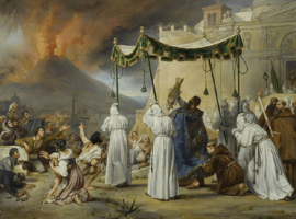 Procession de saint Janvier à Naples pendant une éruption du Vésuve
 -
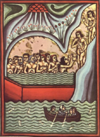 De Balneis Puteolanis


A.2 Summary of you landscape system analysis and your development Targets
- You can summarize your findings with an DPSI(R) Model or a Spider Diagram
- Link back to the Sustainable Development Goals: Which goals are at risk?
- What is your hypothesis for this landscape?
- Visualise your hypothesis with one graphic/pict
- Are there any existing initiatives taking action in this landscape? Do you have a critical perspective on that?
- Add text and visuals
-
explain your analysis briefly in the caption
-
explain your hypthesis briefly in the caption
A.3 Theory reflection
- Reflect on at least three international policy documents in relation to their local landscape case
- choose one international, one European and one national document
- You can choose references from our reading list
- Scope: 250 words
A.4 References
https://en.wikipedia.org/wiki/Mount_Vesuvius https://en.wikipedia.org/wiki/Phlegraean_Fields https://www.wwf.it/oasi/campania/cratere_degli_astroni/ http://www.italianways.com/the-gaiola-underwater-park-naples-below-sea-level/ https://it.wikipedia.org/wiki/Parco_sommerso_di_Gaiola https://www.vulcanosolfatara.it/en/ https://it.wikipedia.org/wiki/Solfatara_di_Pozzuoli https://it.wikipedia.org/wiki/Chiesa_di_Santa_Maria_della_Consolazione_a_Villanova https://it.tripadvisor.ch/Attraction_Review-g194864-d520977-Reviews-Flavian_Amphitheater-Pozzuoli_Province_of_Naples_Campania.html#photos;aggregationId=101&albumid=101&filter=7&ff=377895807 http://www.archeoflegrei.it/necropoli-via-puteolis-neapolim/ https://www.vulcanosolfatara.it/it/news-eventi/blog-vulcano-solfatara-pozzuoli/nella-terra-del-mito/716-la-necropoli-di-san-vito-la-pozzuoli-della-vita-oltre-la-morte https://www.google.com/search?q=santuario+san+gennaro+pozzuoli&tbm=isch&source=lnms&sa=X&ved=0ahUKEwino_qRirLhAhVKwsQBHQ0cAtoQ_AUICygC&biw=1478&bih=728&dpr=1.25 https://www.google.com/search?q=chiesa+di+san+raffaele+arcangelo+pozzuoli&source=lnms&tbm=isch&sa=X&ved=0ahUKEwjWtPbs4rPhAhUN1-AKHVjxCs4Q_AUIDygC&biw=1478&bih=728#imgrc=MDbe4kGd4hlMUM: https://www.google.com/search?q=monumento+ai+caduti+sul+lavoro,+pozzuoli&source=lnms&tbm=isch&sa=X&ved=0ahUKEwjOqaWu47PhAhWIkhQKHS1jAMsQ_AUIDygC&biw=1478&bih=728#imgrc=NPK6vKp7cMJV9M: https://it.wikipedia.org/wiki/Chiesa_di_Santa_Maria_della_Consolazione_(Pozzuoli) https://www.academia.edu/35000970/La_costa_del_golfo_di_Napoli_storia_e_innovazione._Il_Fronte_mare_di_Pozzuoli https://www.google.com/search?q=chiesa+santa+maria+della+consolazione+pozzuoli+orari+messe&source=lnms&tbm=isch&sa=X&ved=0ahUKEwjzl6OY4LPhAhVGAmMBHaCqD80Q_AUIECgD&biw=1478&bih=728#imgrc=_ https://www.google.com/search?q=chiesa+della+purificazione,+pozzuoli&source=lnms&tbm=isch&sa=X&ved=0ahUKEwjW1NL43bPhAhWADmMBHZc3CMYQ_AUIDygC&biw=1478&bih=728&dpr=1.25#imgrc=gD2NkVPSilrVJM: https://www.pozzuoli21.it/videomessaggio-a-figliolia-e-questa-la-pozzuoli-che-pensi-di-aver-cambiato-sotto-gli-occhi-di-tutti/ http://www.saluteatutti.it/pozzuoli-divieto-balneazione-due-tratti-costa/
Phase B: Landscape Evaluation and Assessment
B.1 Assessment Strategy
- Based on the hypothesis derived from your previous landscape systems analysis you are now asked to define the goals for assessing the landscape. Your assessment is the basis for evaluating the landscape status.
- Which elements and phenomena need to be mapped, why and how?
- This a text contribution, max 250 words
B.2 Mapping
- As defined by your assessment strategy you conduct the mapping and present your findings here
- As a minimum, at least three different themes need to be mapped, you may choose more if needed
-
briefly explain the findings of your mapping
-
briefly explain the findings of your mapping
-
briefly explain the findings of your mapping
B.3 Problem definition and priority setting
- Give a summary of the major findings of your mapping process, what are the problems/potentials identified?
- Draw a problems/potentials map
- Set priorities for the most relevant issues
-
add caption here
B.4 Theory reflection
- Please reflect the assessment and evaluation methods used based on at least three readings
- Did you encounter limitations'
- 200 words test contribution
B.5 References
- give a full list of the references you have used for this section
Phase C – Strategy and Master Plan
C.1 Goal Setting
- Define strategic planning objectives based on the evaluation findings
- Link back to your original targets from section one and the Development Goals
- 150 words text contribution
C.2 Spatial Strategy and Transect
- translate your strategic goals into a vision
- develop a spatial translation of your vision
- exemplify your vision in the form of a transect with concrete interventions
- add map(s) and visualizations
-
add caption here
-
add caption here
-
add caption here
-
add caption here
C.3 From Theory of Change to Implementation
- For implementing your vision: Which partnerships are needed? Which governance model is required?
- Who needs to act and how? Draw and explain a change/process model/timeline
- Which resources are needed? On which assets can you build?
- add 150 words text and visuals
-
add caption here
-
add caption here
C.4 References
- give a full list of the references you have used for this section
D. Process Reflection
- Reflect in your intercultural and interdisciplinary team on the outcomes of your study
- Which limitations were you facing?
- What have you learnt from each other?
- What would you do differently next time?
- You can also use diagrams/visuals
- 250 words text