Case Study B.1: Rione Terra-Potus Julius: Difference between revisions
Roberta.izzo (talk | contribs) |
Roberta.izzo (talk | contribs) |
||
| Line 68: | Line 68: | ||
<gallery caption=" " widths="200px" heights="150px" perrow="5"> | <gallery caption=" " widths="200px" heights="150px" perrow="5"> | ||
1234.jpg| | 1234.jpg| | ||
File:1234.jpg|''add a caption'' | ||File:1234.jpg||''add a caption'' | ||
</gallery> | </gallery> | ||
Revision as of 10:36, 12 April 2019
>>>back to working groups overview
| Area | Case Study B.1: Rione Terra - Potus Julius | |
| Place | Pozzuoli, Naples | |
| Country | Italy | |
| Topics | The harbour area, historical center, heritage | |
| Author(s) | Iuca Maria, Neagu Diana, Tanjila Tahsin, Lubna Mansour, Adele Gentile, Roberta Izzo, Geansel Suliman, Irina Midoni | |

| ||
Rationale
- Why do you think this case is relevant? What is your hypothesis considering the landscape challenges?
- Format: 3-4 sentences
Location and scope
You can edit this map with the map editor
A Landscape System Analysis
A.1 Landscape layers and their system context
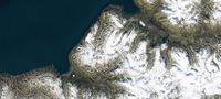
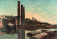
Geomorphology, landscape units and coastal typology
- Description of evolution, status quo and driving forces, is the coastal typology changing? Why is that? (approx 200 signs)
- add 1-2 graphical representations to the image gallery, you can add more if you like
-
 1234
1234 -
add a caption

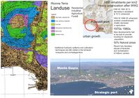
Land use
- settlements, infrastructure, agriculture, resource extraction, natural areas, energy production...
- description of evolution, status quo and driving forces, is the land use likely to change? Why is that? (approx 200 signs)
- add 1-2 graphical representations to the image gallery, you can add more if you like
-
 Landuse
 -
add a caption
-
add a caption

Green/blue infrastructure
Blue and Green infrastructures provides planners, developers and citizens with opportunities to rethink their relationships with the environment. Due to the strong presence of these in the territory, in the study area these represent a potential resource for the development of sustainable economies and tourism.
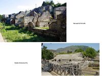
- The Gauro mountain represents the highest volcanic building in the Phlegrean area. The structure is in yellow tuff, in fact, there are some tuff caves now closed. It is in a central position respect to the regional park of the Phlegrean fields. Its structure is bounded by the peaks of Monte Barbaro and Monte Sant'Angelo and is degraded due to atmospheric agents. The mountain is also recognizable from the port of Pozzuoli.
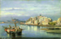
- The port of Pozzuoli has been of great importance since the ancient Greeks. It over the last two thousand years has had several changes due to alterations in the coastline, because of bradyseism. Originally the port was ahead of the current one, while in 1200 the sea reached the area where today it is the Cumana. A new raising is gradually pushing the shoreline away.Many boats leave from the port of Pozzuoli to devote themselves to fishing which is a very important resource for the Phlegraean town.
The Natura 2000 network, provides the enhancement and protection of green spaces, as a habitat of flora and fauna characteristic of the Phlegrean territory, but also because they represent green lungs in an area with a high rate of urbanization. The Mount Gauro,the underwater archaeological reserve of Baia and the Pozzuoli coast represent a uniqueness in the landscape and a place that increases the healthiness of citizens, according to the PUC of Pozzuoli of 2016.The restitution of the Phlegrean coast to the citizens and the protection of marine biodiversity, would lead a strong increase in tourism and economic activities, as well as a greater awareness of the users.
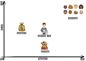
Actors and stakeholders
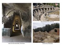
- The archaeological sit Rione Terra is run by the Municipality of Pozzuoli. In the 90s, a restoration project was initiated and a first section, about half of Rione, now has buildings which have been completely saved and restored. The area is known for its naturalistic, landscape, cultural and archaeological uniqueness. Also, there are some other people, who helps to improve the area, such as locals, business man, investors, and even tourists.
-
 Actors and stakeholders

Sacred spaces and heritage
-
 add a caption
 -
 add a caption
 -
 add a caption


Visual appearance and landscape narrative
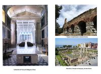
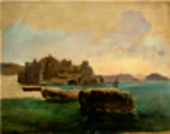
- Over the time, for many painters and artists Rione Terra represented a great scenario for their works. Perhaps, the history had an important role that appealed many masters of the beautiful arts, from the Roman colony that dates since 194 BC and Greek influences, to the reconstruction of a new city in the last 50 years. The landscape and natural elements of Rione Terra have been caught in several paintings such as the Frantz Loudwig Castle-Pozzuoli by Gabriele Smargiassi and Rione Terra a Pozzouli by Consalvo Carrelli, both of them realized in the 19th century. In these works we can see the relation between water and cliffs and also the layers of the natural environment. In the background, even with its positions is far from the principal settlement, they have marked the horizon line with the silhouette of Vesuvius Vulcano that seems to have a big impact on the global image.
- Furthermore, Rione Terra and her surroundings have represented the filming location for a number of movies and documentaries. One of them, The Vesuvians (italian: I vesuviani), was directed by Mario Martone in 1997 and tells the story of a fisherman living in Rione Terra. The harbor, the old streets, the waves breaking on the shore as well as the Vesuvio volcano were often chosen as a background for the movie scenes. Another movie that captures the coastal landscape of Pozzuoli is The man from the U.N.C.L.E., directed by Guy Ritchie in 2015.
https://www.imdb.com/search/title?locations=Pozzuoli,%20Naples,%20Campania,%20Italy&ref_=ttloc_loc_2
-
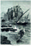 Incisione del 1878
 -
 Il Rione Terra
 -
 CARELLI Consalvo (Consalve)
 -
 The Temple of Serapis in Pozzuoli
 -
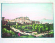 Veduta della città di Pozzuoli
 -
 I vesuviani (1997)
 -
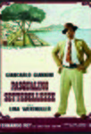 Pasqualino Settebellezz 1975


.jpg)


.jpg)

A.2 Summary of you landscape system analysis and your development Targets
- You can summarize your findings with an DPSI(R) Model or a Spider Diagram
- Link back to the Sustainable Development Goals: Which goals are at risk?
- What is your hypothesis for this landscape?
- Visualise your hypothesis with one graphic/pict
- Are there any existing initiatives taking action in this landscape? Do you have a critical perspective on that?
- Add text and visuals
-
explain your analysis briefly in the caption
-
explain your hypthesis briefly in the caption
A.3 Theory reflection
- Reflect on at least three international policy documents in relation to their local landscape case
- choose one international, one European and one national document
- You can choose references from our reading list
- Scope: 250 words
A.4 References
- give a full list of the references you have used for this section
Phase B: Landscape Evaluation and Assessment
B.1 Assessment Strategy
- Based on the hypothesis derived from your previous landscape systems analysis you are now asked to define the goals for assessing the landscape. Your assessment is the basis for evaluating the landscape status.
- Which elements and phenomena need to be mapped, why and how?
- This a text contribution, max 250 words
B.2 Mapping
- As defined by your assessment strategy you conduct the mapping and present your findings here
- As a minimum, at least three different themes need to be mapped, you may choose more if needed
-
briefly explain the findings of your mapping
-
briefly explain the findings of your mapping
-
briefly explain the findings of your mapping
B.3 Problem definition and priority setting
- Give a summary of the major findings of your mapping process, what are the problems/potentials identified?
- Draw a problems/potentials map
- Set priorities for the most relevant issues
-
add caption here
B.4 Theory reflection
- Please reflect the assessment and evaluation methods used based on at least three readings
- Did you encounter limitations'
- 200 words test contribution
B.5 References
- give a full list of the references you have used for this section
Phase C – Strategy and Master Plan
C.1 Goal Setting
- Define strategic planning objectives based on the evaluation findings
- Link back to your original targets from section one and the Development Goals
- 150 words text contribution
C.2 Spatial Strategy and Transect
- translate your strategic goals into a vision
- develop a spatial translation of your vision
- exemplify your vision in the form of a transect with concrete interventions
- add map(s) and visualizations
-
add caption here
-
add caption here
-
add caption here
-
add caption here
C.3 From Theory of Change to Implementation
- For implementing your vision: Which partnerships are needed? Which governance model is required?
- Who needs to act and how? Draw and explain a change/process model/timeline
- Which resources are needed? On which assets can you build?
- add 150 words text and visuals
-
add caption here
-
add caption here
C.4 References
- give a full list of the references you have used for this section
D. Process Reflection
- Reflect in your intercultural and interdisciplinary team on the outcomes of your study
- Which limitations were you facing?
- What have you learnt from each other?
- What would you do differently next time?
- You can also use diagrams/visuals
- 250 words text