COLAND Case Study 2020 - Brugge - Zeebrugge
>>>back to working groups overview
Rationale
- Why do you think this case is relevant? What is your hypothesis considering the landscape challenges?
- Format: 3-4 sentences
Location and scope
You can edit this map with the map editor
A Landscape System Analysis
A.1 Landscape layers and their system context
Geomorphology, landscape units and coastal typology
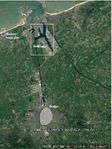
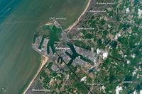
The name of the city comes from the word "Bryghia", meaning ‘landing stage' in Norse. It is an example of the medieval settlement. Bruges was named in 2002 as a cultural capital and is considered a UNESCO World Heritage Site From the beginning of its development, Bruges had has an important connection with the coast. Originally it was a landing place on the Zwin estuary, into which the Reie River flowed. In the 12th century, Bruges gained city status, but soon after the Zwin started to silt up. Bruges adapted by creating outports in Damme and Sluis; simultaneously, land transport became more and more prevalent. Another important factor in the costal zone of the studio area is the Blankenberge pier built in 1933. Likewise, the port of Zeebrugge (initially a village) has been developed since 1895. This is the area with the biggest changes since the small fishing settlement, dating from the end of the 19th century that was surrounded by natural beaches and dunes, was dwarfed by the enormous manmade harbour. All these interventions show the important commercial influence of the city, according to which, the coast typology can be defined as a set of man-made interventions among which, the tourist and commercial activities of the port are the most significant of the environment given its proportions.
Land use
- settlements, infrastructure, agriculture, resource extraction, natural areas, energy production...
- description of evolution, status quo and driving forces, is the land use likely to change? Why is that? (approx 200 signs)
- add 1-2 graphical representations to the image gallery, you can add more if you like
Blue/Green Infrastructure
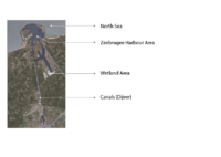
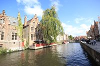
Blue Infrastructure: There are 4 Major elements of existing Blue Infrastructure. 1st one is obviously the North Sea which is connecting Belgium with the western side. Then there is the Zeebrugge harbour area. Although it is a part of the sea, it has an enclosed site area with different functions, so it can be marked as a separate and most dominant element Blue Infrastructure of that area. After that, there are two canal connections here in this site. One is connecting the city harbour with the main port area, and the other is connecting with the Dijver canal. This canal connection is well spread in the Brugee city and that’s why this city is called the “Venice of the North”.And the last one is the Wetland area, located in the side of Zeeburgee Harbor which actually helps to improve the water quality, reduce coastal storm damage and maintain ecosystem productivity.
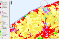
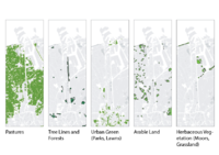
Green Infrastructure: From the map, it’s notable that the most of the study area except Zeebrugge harbour is occupied by Pastureland – which is generally covered with grass and other low plants and suitable for grazing animals, especially cattle or sheep. Then there a small portion of forest and Treelines. It is actually the green canopied area beside the canals and some small chunk of tress. Then there is the 3rd map of Urban Green area, which consists of Parks, Lawns and green recreational area. After that, there is some arable land in between the Pasture lands, which are used for agriculture and farming. And lastly, there is some herbaceous Vegetation, which is consist of Moors and grassland.
Actors and stakeholders
- Who is driving changes in this landscape? Who is affected by those changes?
- Draw a stakeholder and/or power map: Who is affected highly but with low power? Who has high power but is not affected?
- Your case your powermap.jpg
add a caption
Sacred spaces and heritage
- Bruges is the capital and largest city of the province of West Flanders in the Flemish Region of Belgium, in the northwest of the country.
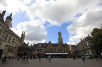
The area of the whole city amounts to more than 13,840 hectares (138.4 km2; 53.44 sq miles), including 1,075 hectares off the coast, at Zeebrugge.The historic city centre is a prominent World Heritage Site of UNESCO. It is oval in shape and about 430 hectares in size. The city's total population is 117,073 (1 January 2008), of whom around 20,000 live in the city centre. The metropolitan area, including the outer commuter zone, covers an area of 616 km2 (238 sq mi) and has a total of 255,844 inhabitants as of 1 January 2008. Along with a few other canal-based northern cities, such as Amsterdam and St Petersburg, it is sometimes referred to as the Venice of the North. Bruges has a significant economic importance, thanks to its port, and was once one of the world's chief commercial cities.
- You may add a map and some images, please also explain in your caption why these elements are valuable
Visual appearance and landscape narrative
- Which elements are essential for the landscape character?
- Has the landscape been painted or otherwise depicted, when and whom? Which elements are essential?
- Which narratives exist? Who has written about this landscape or depicted it in some way?
- You can add text and images
- Your case character3.jpg
add a caption
A.2 Summary of your landscape system analysis and your development targets
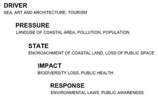
- You can summarize your findings with an DPSI(R) Model or a Spider Diagram
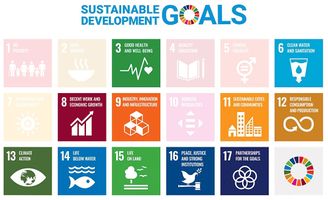
- Link back to the Sustainable Development Goals: Which goals are at risk?
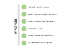
- What is your hypothesis for this landscape?
- Visualise your hypothesis with one graphic/pict
- UNESCO World Heritage Conservation works for the conservation of historical sites across the globe. The city of Brugge, being on coast is susceptible to global change in sea level due to climate change. USESCO being an international organization is capable of mitigation of global calamities. However, due to its international working arena, the concentration on the specific city (Brugge in this case) may not be sufficient.
- Add text and visuals
Goals at risk includes-> Goal 3: Good health and well-being for people Goal 6: Clean water and sanitation Goal 8: Decent work and economic growth Goal 11: Sustainable cities and communities Goal 12: Responsible consumption and production Goal 13: Climate action Goal 14: Life below water Goal 15: Life on land Goal 17: Partnerships for the goals
A.3 Theory reflection
- Reflect on at least three international policy documents in relation to their local landscape case
- choose one international, one European and one national document
- You can choose references from our reading list
- Scope: 250 words
A.4 References
- give a full list of the references you have used for this section
Phase B: Landscape Evaluation and Assessment
B.1 Assessment Strategy
- Based on the hypothesis derived from your previous landscape systems analysis you are now asked to define the goals for assessing the landscape. Your assessment is the basis for evaluating the landscape status.
- Which elements and phenomena need to be mapped, why and how?
- This a text contribution, max 250 words
B.2 Mapping
- As defined by your assessment strategy you conduct the mapping and present your findings here
- As a minimum, at least three different themes need to be mapped, you may choose more if needed
- Your case your assessment mapping themel.jpg
briefly explain the findings of your mapping
- Your case your assessment mapping theme2.jpg
briefly explain the findings of your mapping
- Your case your assessment mapping theme3.jpg
briefly explain the findings of your mapping
B.3 Problem definition and priority setting
- Give a summary of the major findings of your mapping process, what are the problems/potentials identified?
- Draw a problems/potentials map
- Set priorities for the most relevant issues
- Your case problems potentials map.jpg
add caption here
B.4 Theory reflection
- Please reflect the assessment and evaluation methods used based on at least three readings
- Did you encounter limitations'
- 200 words test contribution
B.5 References
- give a full list of the references you have used for this section
Phase C – Strategy and Master Plan
C.1 Goal Setting
- Define strategic planning objectives based on the evaluation findings
- Link back to your original targets from section one and the Development Goals
- 150 words text contribution
C.2 Spatial Strategy and Transect
- translate your strategic goals into a vision
- develop a spatial translation of your vision
- exemplify your vision in the form of a transect with concrete interventions
- add map(s) and visualizations
- Your case spatial translaton vision.jpg
add caption here
- Your case transect.jpg
add caption here
- Your case transect detail1.jpg
add caption here
- Your case transect detail2.jpg
add caption here
C.3 From Theory of Change to Implementation
- For implementing your vision: Which partnerships are needed? Which governance model is required?
- Who needs to act and how? Draw and explain a change/process model/timeline
- Which resources are needed? On which assets can you build?
- add 150 words text and visuals
- Your case spatial your governance model.jpg
add caption here
- Your case spatial your process model.jpg
add caption here
C.4 References
- give a full list of the references you have used for this section
D. Process Reflection
- Reflect in your intercultural and interdisciplinary team on the outcomes of your study
- Which limitations were you facing?
- What have you learnt from each other?
- What would you do differently next time?
- You can also use diagrams/visuals
- 250 words text


