COLAND Case Study 2020 - Brugge - Zeebrugge
>>>back to working groups overview
| Area | Zeebrugge | |
| Place | Brugge | |
| Country | Belgium | |
| Topics | Zeebrugge Port, Natura 2000 SItes | |
| Author(s) | Shaurav Paul, Md Zasim Uddin, Chiara Lofferdi, Melissa Zapata, Balient, Nahian Zobaid, Amala sunny, Nayan Jeel | |

| ||
Rationale
Zeebrugge is located on the very western side of Belgium. The nearby city is Brugge, which has historical significance and also a great location for tourism nowadays. This area is one of the major economic hubs of Belgium. Zeebrugge harbour, which is one of the 4 harbours of Belgium, is located here. This harbour had direct access to the North sea. This area is also famous for sea-side recreation and tourism. Mane industries are growing here. Besides, there are some special Natura 200 sites alongside.
Because of all the reason, this site has very special characteristics for the study and development policy of Coastal Landscape Development.
Location and scope
You can edit this map with the map editor
A Landscape System Analysis
A.1 Landscape layers and their system context
Geomorphology, landscape units and coastal typology
The name of the city comes from the word "Bryghia", meaning ‘landing stage' in Norse. It is an example of the medieval settlement. Bruges was named in 2002 as a cultural capital and is considered a UNESCO World Heritage Site From the beginning of its development, Bruges had has an important connection with the coast. Originally it was a landing place on the Zwin estuary, into which the Reie River flowed. In the 12th century, Bruges gained city status, but soon after the Zwin started to silt up. Bruges adapted by creating outports in Damme and Sluis; simultaneously, land transport became more and more prevalent. Another important factor in the costal zone of the studio area is the Blankenberge pier built in 1933. Likewise, the port of Zeebrugge (initially a village) has been developed since 1895. This is the area with the biggest changes since the small fishing settlement, dating from the end of the 19th century that was surrounded by natural beaches and dunes, was dwarfed by the enormous manmade harbour. All these interventions show the important commercial influence of the city, according to which, the coast typology can be defined as a set of man-made interventions among which, the tourist and commercial activities of the port are the most significant of the environment given its proportions.
-
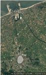 Brugge 1984. Source: Google Earth
 -
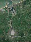 Brugge 2018. Source: Google Earth


Land use
-
 In 1990 the landuse of this area was characterized mainly by the urban fabric of Brugge and the cities along the coast. In between of them there was mainly just agricultural land.
 -
 In 2018 the situation changes: the port area expanded and there are new infrastructure areas in between Brugge and Zeebrugge.
 -
 Here we proposed a possible scenario for 2050 for the landuse, based on the evolution during the previous years.


Blue/Green Infrastructure
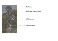
Blue Infrastructure: There are 4 Major elements of existing Blue Infrastructure. 1st one is obviously the North Sea which is connecting Belgium with the western side. Then there is the Zeebrugge harbour area. Although it is a part of the sea, it has an enclosed site area with different functions, so it can be marked as a separate and most dominant element Blue Infrastructure of that area. After that, there are two canal connections here in this site. One is connecting the city harbour with the main port area, and the other is connecting with the Dijver canal. This canal connection is well spread in the Brugee city and that’s why this city is called the “Venice of the North”.And the last one is the Wetland area, located in the side of Zeeburgee Harbor which actually helps to improve the water quality, reduce coastal storm damage and maintain ecosystem productivity.
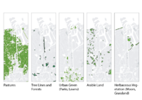
Green Infrastructure: From the map, it’s notable that the most of the study area except Zeebrugge harbour is occupied by Pastureland – which is generally covered with grass and other low plants and suitable for grazing animals, especially cattle or sheep. Then there a small portion of forest and Treelines. It is actually the green canopied area beside the canals and some small chunk of tress. Then there is the 3rd map of Urban Green area, which consists of Parks, Lawns and green recreational area. After that, there is some arable land in between the Pasture lands, which are used for agriculture and farming. And lastly, there is some herbaceous Vegetation, which is consist of Moors and grassland.
-
 Blue Infrastructure
 -
 Green Infrastructure


Actors and stakeholders
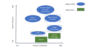
In the federal structure of Belgium, Flanders Region has full powers for spatial and environmental planning (industrial and economic development, seaports, coastal infrastructure, natural areas etc.) while the federal government has limited or no power in these matters. To varying degrees, both West-Flanders Province and Brugge Municipality, play a role of conversion through structural and implementation plans. Change in the Zeebrugge area is predominantly driven by seaport development and the related economies and investments, as well as by the compensation scheme to create new natural sites. Because these competencies primarily belong to the Flemish Region and the West-Flanders Province, and not to the city of Brugge, citizens who are living in this territory has limited power to influence policymaking.
-
 Actors Map

Sacred spaces and heritage
Bruges is the capital and largest city of the province of West Flanders in the Flemish Region of Belgium, in the northwest of the country. The area of the whole city amounts to more than 13,840 hectares (138.4 km2; 53.44 sq miles), including 1,075 hectares off the coast, at Zeebrugge. The historic city centre is a prominent World Heritage Site of UNESCO. It is oval in shape and about 430 hectares in size. The city's total population is 117,073 (1 January 2008), of whom around 20,000 live in the city centre. The metropolitan area, including the outer commuter zone, covers an area of 616 km2 (238 sq mi) and has a total of 255,844 inhabitants as of 1 January 2008. Along with a few other canal-based northern cities, such as Amsterdam and St Petersburg, it is sometimes referred to as the Venice of the North. Bruges has significant economic importance, thanks to its port, and was once one of the world's chief commercial cities. Bruges was a location of coastal settlement during prehistory. This Bronze Age and Iron Age settlement are unrelated to medieval city development. In the Bruges area, the first fortifications were built after Julius Caesar's conquest of the Menapii in the first century BC, to protect the coastal area against pirates. The Franks took over the whole region from the Gallo-Romans around the 4th century and administered it as the Pagus Flandrensis. The Viking incursions of the ninth century prompted Count Baldwin I of Flanders to reinforce the Roman fortifications; trade soon resumed with England and Scandinavia. Early medieval habitation starts in the 9th and 10th century on the Burgh terrain, probably with a fortified settlement and church.
Bruges has most of its medieval architecture intact, making it one of the best-preserved medieval towns in Europe. The historic centre of Bruges has been a UNESCO World Heritage Site since 2000. Many of its medieval buildings are notable, including the Church of Our Lady, whose brick spire reaches 115.6 m (379.27 ft), making it the world's second-highest brick tower/building. The sculpture Madonna and Child, which can be seen in the transept, is believed to be the only of Michelangelo's sculptures to have left Italy within his lifetime.
Bruges' most famous landmark is its 13th-century belfry, housing a municipal carillon comprising 47 bells. The city still employs a full-time carillonneur, who gives free concerts on a regular basis.
Other famous buildings in Bruges include:
The Béguinage (Dutch: Begijnhof), The Basilica of the Holy Blood (Dutch: Heilig-Bloedbasiliek). The relic of the Holy Blood, which was brought to the city after the Second Crusade by Thierry of Alsace, is paraded every year through the streets of the city. More than 1,600 inhabitants take part in this mile-long religious procession, many dressed as medieval knights or crusaders. The modern Concertgebouw ("Concert Building"), The Old St. John's Hospital, The Saint Salvator's Cathedral, The Groeningemuseum, which has an extensive collection of medieval and early modern art, including a notable collection of Flemish Primitives. Various masters, including Hans Memling and Jan van Eyck, lived and worked in Bruges. The City Hall on the Burg (Bruges) square, The Provincial Court (Provinciaal Hof), The preserved old city gateways: the Kruispoort, the Gentpoort, the Smedenpoort and the Ezelpoort. The Dampoort, the Katelijnepoort and the Boeveriepoort are gone.
-
 Historical_timeline_of_Brugge
 -
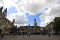 Brugge City center.JPG
 -
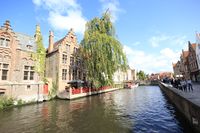 Canel Way


Visual appearance and landscape narrative
01. Brugge has no specific sea beach
02. 1,075 hectares coastal area majorly occupied by Zeebrugge port
03. 12 km long Baudouin Canal with the North Sea.
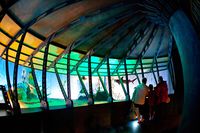
04. visitors can enjoy the story of coastal tourism past and present through the maritime theme park, situated in the unique setting of the old fish market in Zeebrugge
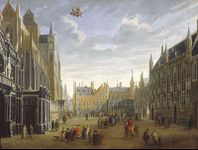
05. The unique medieval pattern of streets, places and open spaces are depicted in a painting by a famous Flemish painter Jan Baptist van Meunincxhove in1691–1700
-
 add a caption
 -
 add a caption
 -
 add a caption


A.2 Summary of your landscape system analysis and your development targets
UNESCO World Heritage Conservation works for the conservation of historical sites across the globe. The city of Brugge, being on coast is susceptible to global change in sea level due to climate change. UNESCO being an international organization is capable of mitigation of global calamities. However, due to its international working arena, the concentration on the specific city (Brugge in this case) may not be sufficient.
-
 Public awareness and mass movement are a most important and effective tools to counter degrading Urban environment

-
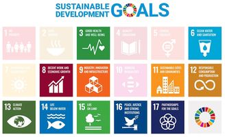 Goals at risk includes-> Goal 3: Good health and well-being for people Goal 6: Clean water and sanitation Goal 8: Decent work and economic growth Goal 11: Sustainable cities and communities Goal 12: Responsible consumption and production Goal 13: Climate action Goal 14: Life below water Goal 15: Life on land Goal 17: Partnerships for the goals

-
 Inadequate city and environmental regulation leads to encroachment of land near sea which limits and/or degrades public life, ultimately degrading the growth and economy

-
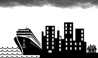 Encroachment of the coastal land is an attack on public life and well being. The cruise ships and concrete building jungles may look fancy for tourists or outsiders but it makes the citizens feel trapped inside the city. The dark clouds above symbolize the gross unhappiness

A.3 Theory reflection
During our studies we found out that many international policies have been released in the years, but of all of them we found more important these ones:
- the European Landscape Convention: which promotes the protection, management and planning of the landscapes
- the Bern Convention: about the nature conservation
- the European Code of Conduct for Coastal Zones: which comprises specific recommendations, practical and realistic principles and rules on best practice for local, regional and national authorities, spatial planners, coastal engineers and users.
- the Model Law on Sustainable Management of Coastal Zones: defines the concept of integrated management and planning, based on the principle of sustainable development.
Thereafter, we found three documents that are more specifically related to our case study, which are:
- The Protocol on Integrated Coastal Zone Management (ICZM Protocol): which was adopted by the COP18. It is a document shared between multiple countries like the European Union, Tunisia, Syria, Morocco, Israel..
- The Water Framework Directive: it aims to protect water and its natural geographical formations. It also deals with pollutants and climate change challenges, related to water.
- “Masterplan for Coastal Safety”: which has been approved by the Flemish Government in 2011, and is currently being implemented. It aims to protect the coast from erosion, sea level rise and storms with a return period of 1000 years. This masterplan covers the mid-term and has a time horizon that extends to 2050.
- Reflect on at least three international policy documents in relation to their local landscape case
- choose one international, one European and one national document
- You can choose references from our reading list
- Scope: 250 words
A.4 References
https://en.wikipedia.org/wiki/Zeebrugge
https://de.wikipedia.org/wiki/Zeebrugge
https://portofzeebrugge.be/en/port/history
https://coastal-management.eu/node/211
https://land.copernicus.eu/local/urban-atlas
https://land.copernicus.eu/pan-european/corine-land-cover
https://www.coe.int/en/web/landscape
Managing European Coasts: Past, Present and Future
https://eur-lex.europa.eu/legal-content/EN/TXT/?uri=CELEX%3A22009A0204%2801%29
http://paprac.org/iczm-protocol
https://coastal-management.eu/governance/belgium
Phase B: Landscape Evaluation and Assessment
B.1 Assessment Strategy
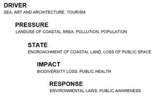
From the last phase of the study “Landscape System Analysis”, we have identified some core factors & elements that have influences in our study area. Some of those factors are- Zeebrugge Port, The encroachment of Coastal land and converting into concrete jungles, the touristic city with very limited sea exposure, Oversaturation of economic growth and limited access to green space and coastline along with the North Sea. So we sorted our goals for this landscape assessment regarding those dominant factors in this area. Our three goals are-
Goal 01: Defining the pressure of Gray infrastructure and improving the condition of existing blue infrastructure
Goal 02: Generating more access to Green infrastructure along the beach area.
Goal 03: Indicating the Development threats along the coastline to the Protected Natural Site
In order to access our case study site, we have decided the following three themes to be mapped-
Map 1: Transportation -To show the concentration and distribution of roads and railways
Map 2: Green infrastructure ratio -To understand the ratio of green spaces compared to gray settlements
Map 3: Gradual Urban Development pattern with Natural Protected Sites -To analysis the economic infrastructure development trend (Industry and Housing Settlement) along with the coastline and its relation/collision with the natural protected sites
B.2 Mapping
Mapping Theme 1: Transportation
The Zeebrugge Port attracts many tourists who arrive at the Port from cruise ships, and the goal is to improve public transport accessibility to and from Brugge while utilising the existing blue infrastructure of the landscape. Currently, Zeebrugge is serviced through land-based connectivity options: train, coastal tram, bus and road links. But, the inland waterway between the Port and the city can offer a water-based transport option.
Why? - land-based public transport options (train, tram, and bus) because these options are the most frequently used by tourism arriving at/from the cruise ship terminals at the Zeebrugge Port. -blue infrastructure between Zeebrugge Port and Brugge because that’s where we can explore new potentials for connectivity
-
 Transportation Map

Mapping Theme 2: Green Infrastructure Ratio
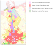
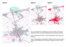
In this map, we tried to understand the ratio of four types of green spaces compared to grey settlements. The types are 1. Accessible green for agriculture 2. Accessible green for recreation 3. Possible expansion of future green 4. Restricted green space for the pedestrian. Brugge city has more than 50% direct accessible green for agriculture and recreation that is positive for inhabitants, tourists and finally, it will help to reduce the pollution generated from grey infrastructures. The main challenge from the green perspective in this site is about 15% regulated green space in between the Zeebrugge port which has lost the accessibility for tourists and pedestrians.
Why? As the coastal landscape in Brugge site is especially characterized by Zeebrugge port, a direct pedestrian connection to the sea and surrounding green spaces is regulated here. On the other hand, the city enjoys a lot of accessibility to green spaces for recreation and agriculture purposes.
-
 Green Infrastructure Ratio Map

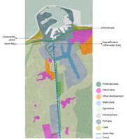
Mapping Theme 3: Gradual Urban Development pattern with Natural Protected Sites
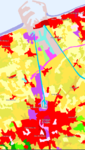
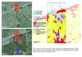
Here in this map, we can see the gradual development of basic-socio economic land cover. If we see the basic land use map of port, industry and the housing from Google earth map of 1984 and 2020, we can see that the Urban Developments are taking more and more land. And they are taking away the lands from agrarian fields. And from the Corine land cover map on the right site, we can notice that almost the whole coastline is covered with port, apartment blocks and industrial functions and a very few areas are naturally exposed to the sea. It is also clearly noticeable that the density of the urban fabric is higher along with the coast.
-
 Development Threat_Land Cove

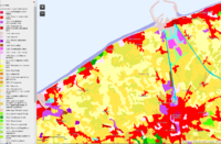
In our site, there is a considerable portion of protected areas according to the Natura 2000 Protected area network. From the map, we can see that there are 5 Special Protection Areas (SPAs) for Bird Directives and 3 Special Areas of Conservation (SACs) for Habitat Directives. But there is no soft buffer zone in between the protected sites and the development zone. And the ongoing development process is causing a risk to those natural sites and also the coastal landscape ecosystem.
-
 Development Threat_Protected Area

B.3 Problem definition and priority setting
Risks:
1. The continuous movement of the ship and cargo vehicles in the port area are causing pollution to the water and degrading the water quality of this coastal area.
2. The close attachment of the harbour with the Natura 2000 Bird protection Site. The movement and activity of ships and ports can hamper the habitat's lifestyle.
3. Then there are rapid developing Industrial areas and apartment blocks beside the coastline. It is taking away the exposure of the coastal line and also degrading the nature of the coastal area.
4. Discontinuous and disturbed coastline in the site. The beach is heavily segregated by the port and it is creating two different pictures on two sides of the port. On the left side, there are some natural sand beaches and some housing blocks. And on the right side is quite posh looking where there is the industry and also big residential areas. The beach on the right side is more organized and polished looking for tourist intervention like a caravan, beach chair, clubs and outdoor restaurants. But there is no soft infrastructure to pass into the port.
5. Special Areas of Conservation (SACs) for Habitat Directives are located just beside the coastline. So the climate change, sea level rising and coastal pollution can harm the specialities of that area.
6. Fragmentation of Habitats by the linear port area. From the aerial view, it looks like it is separating the whole area by a straight line.
7. Over Exploitation of land-based connectivity (streets and railways) beside the coastline
8. Existing but under-utilizes waterways between Zeebrugge and Brugge
Potentials:
1. Great scope for developing coastal tourism. Sand beach in front of Knokke-Heist Housing Area has already developed a touristic setup.
2. The waterways/canal Between Zeebrugge Port and the Brugge city- which can be turned into a touristic infrastructure along with post-activity
3. Opening of Harbour Heritage as a part of tourists activity
4. Potential Zones for Accessible Green for the tourists and the local inhabitant in the whole site
5. And finally, there is Potentiality about the green tree line in the bank of canals, which can transform into public recreational space very easily.
-
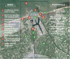 Risk and Potential Map

Priority Goal:
From all the analysis, mapping and problem-potential findings, we have developed one goal, which will drive us to the design and planning phase. The goal is-
Improving touristic Infrastructure maintaining the natural settings of the coastline
For accomplishing the Goal in the design phase, we have also sorted out targets, which can as indicators also. Those are-
1. Sustainable Socio-economic development by conserving the protected area.
2. Developing walkways and bike trails between two side of the harbour.
3. Give attractiveness to the harborside.
4. Generating more accessible green space in between the port and surrounding the beach area considering port security.
5. Developing water-based public transportation
B.4 Theory reflection
As we proceeded with the study of the area, we found many difficulties related to the physical knowledge of the specific site. We also found out that even though maps can be full of informations, the analysis of the place will always be incomplete without the personal perception.
Another obstacle for us was the complexity of the coastal landscape, especially regarding the city-shoreline relationship. In just a few kilometers we can encounter coasts, port, agriculture, urban fabric and water bodies.
The main points we got from our readings are:
- 1. The importance of incorporating Green Infrastructures in the urban fabric, not only for the ecological factor, but also for people.
- 2. The different features that characterize the north sea, making it different from all the other seas.
- 3. Coastal protection using feeder berm and nourishment - Erosion case study of De Haan, Belgium
- 4. Sustainable cities and communities (Goal 11, SDG)
B.5 References
https://natura2000.eea.europa.eu/
https://land.copernicus.eu/pan-european/corine-land-cover
https://sustainabledevelopment.un.org/?menu=1300
Erosion case study of De Haan, Belgium
https://www.gov.uk/government/publications/risk-potential-assessment-form
https://www.esri.com/en-us/arcgis/data-management
Phase C – Strategy and Master Plan
C.1 Goal Setting
Goals & Vision:
From the landscape assessment exercise, we have developed a bigger picture as our Vision and the priority goal for the planning and design phase of the Zeebrugge case study area.
Vision: Making Maritime Postcard
Goal: Improving touristic Infrastructure maintaining the natural settings of the coastline
From Goal and Vision, we have developed 4 precise targets, which are our objectives to accomplish.
1. Developing a Touristic Trail as a green mobility network, which will connect all the main spots around this area and make it easier to access for everyone (SDG:9)
2. Developing the “New Boudewijnkanaal” as a new opportunity of infrastructure (SDG:9)
3. Preserving the protected site as a “Learning Hub” (SDG:15)
4. Restricting the development trend for “Preserving Coastal Life” (SDG:3, SDG:6, SDG:11)
From developing the goals, we have considered 5 major sustainable goal parameter, those are- Good Health and well-being (SDG-3), Clean Water and Sanitation (SDG-6), Industry, Innovation and Infrastructure (SDC-9), Sustainable cities and communities (SDG-11) and Life on Land (SDG-15)
-
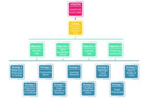 Whole Planning Structure

C.2 Spatial Strategy and Transect
Master Plan Action Plan for reaching the objectives:
1. The touristic trail will consist of 2 types of infrastructure elements- Waterways and Pedestrian & Cycling mobility. This will promote a sustainable way to explore the coastal attractions.
2. Creating a community and tourists open space on the left side of the harbour, by cleaning the coast side and constructing seating and walkways along the beach
3. Providing information boards & signs to inform about the protected birds and habitats in the periphery of Natura 2000 protected sites. Connect those areas with a green mobility network.
4. Redesigning the canal activity by including touristic transport service in between port and city by boat or small cruise ship.
5. Constructing deck and bridge in the canal bank for recreational, view and soft mobility regards
6. Developing pedestrian and cycling pathways along with the canal, which can also connect with new recreational hub/point
7. A green mobility corridor passing through the harbour, which will connect the 2 segregated beaches in 2 sides of the port and it also can reduce the dominance of saturated vehicular infrastructure.
8. Proposing policy to change the direction of housing and industrial development. This should be perpendicular with the beach instead of parallel direction with the coastline.
9. Developing public promenade in front of the housing settlement, for reducing the possibilities of coastal erosion and decreasing the touristic pressure directly on the sea-coast
-
 Spatial Strategic Plan

In the Transect, we have located 3 points, where we have developed our interventions. Those points are-
01. CANAL
02. ZEEBRUGGE PORT
03. BEACH AREA
-
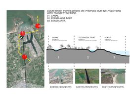 Transect

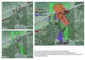
Acupuncture Point 1:
This point is located inside of the port, which is a connecting highway between two portions of the beach. We have considered the point for acupuncture because we thought this point can solve some issues regarding our vision and goal. As the port is dividing the beach in two-part, this road is the only way of communication. But the configuration of the existing road is not suitable for soft mobility. As we are proposing the connection between the two sides and also promoting this harbour as a tourist attraction, we have tried to make some intervention at this point. We have proposed a tree-canopied pedestrian and bike path on both sides of the existing road. This will try to minimize the poor walkable connection between the two-part of the coast. It will also encourage people to walk or bike inside the harbour because a port is always a point of interest to the general people for its huge infrastructure and working style. We have proposed a green strip in between the two opposite lanes of the road, to create a green buffer. Besides, we are thinking of providing an observation deck at some point to attract the local people as well as the tourists to come here and observe the activity of the port activities.
-
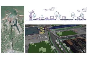 Acupuncture Point 1_Inside of Port Area

Acupuncture Point 2:
This area is the existing side of Boudewijn canal. Currently, this canal is only working as transporting goods from the main port to the city harbour. But as Brugge city is called the Venice of the north and it has a quite impressive water-based infrastructure among the city, we are thinking to expand this infrastructure till the harbour. We are using the existing canal and developing its configuration. We are proposing a tourist boat or cruise in the canal, which can transport tourists as well as the local inhabitants to the port area. We are thinking of providing a walkable and biking path in the side of the canal so that it can convert to a daily recreation area for all. We are also thinking about some viewing deck and bridges on the canal, which will create a waterfront in small scale and attract the people. The existing tree lines in the 2 side of the canal will serve as green recreational space, whereas some open space can be converted as a picnic spot.
-
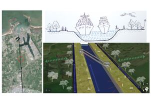 Acupuncture Point 2_Boudewijn canal

Acupuncture Point 3:
This point is on the right side of the port and in front of Knokke Heist housing settlement. The settlement is in just side of a road, where the other side of the road is direct coast. We are afraid of aggressive housing and industrial development by observing the past extension pattern. We are thinking to build a public promenade in the roadside so that it can serve 2 purposes. It will protect the area to convert into any development structure and it will also provide a recreational facility to the local people and the tourists. As this promenade will create a buffer, it will also help to reduce coastal erosion and decrease the direct pressure of tourism activity in the natural sea coast.
-
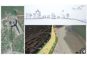 Acupuncture Point 3_Right coast of Harbour

C.3 From Theory of Change to Implementation
After the planning and design process, we have sorted out about the partnership, governance and the implementation stage.
Basically the whole development theme can be divided into 5 basic steps,
1. Research and Analysis
2. Concept Development
3. Planning and Design
4. Implementation and
5. Maintenance and Evaluation.
First, the Specialist, architects, landscape architects and concerning authorities will analyse the whole area and research about the problem and potentialities. Then after getting financial aid, they will start the concept development and the planning process. After that, the construction will happen with the supervision of designers and the governing authorities. After implementing the idea, maintenance and evaluation process will start. The whole process is actually a rotation way. As the whole development will not be implemented at a single time, so the result from the evaluation will add up with the previous steps also, which will help to modify some issues for getting the better result.
-
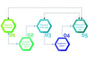 Steps for Development

We tried to make a time phase for the development works. We divided the time into 3 phases. 1st two phases consist of 5 years each and the last phase will be continued until getting the perfect and desired outcome. It will also depend on the perfections from first two-phase.
Hypothetically, we took our 9 major strategies as the task of planning and development phase. The touristic trail, pedestrian, biking path along with the canal, and knowledge sharing activity in the protected area will be the 1st phase of work. After that, the authority can start developing the community space along the beach, the green mobility corridor into the port and the public promenade development. After that, the deck, the pedestrian bridge on the canal can happen. And within all the time, the authority can change the land use plan so that the settlement can extend in perpendicular with the see toward the city, not parallel blocking the coastline.
-
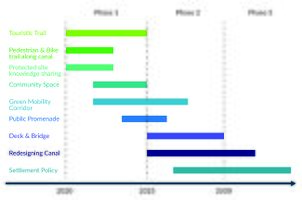 Development Timeline

And finally, we tried to sort out all the related actors and stakeholders, who will support and be responsible for the whole process. As we have 3 types of area in our site, we divided them and tried to sort out, who will act on which area and who will provide financial help, who will plan, who will do the management and who will protect the whole process.
Suppose the European authority will finance and manage the protected site while NGO, govt and local municipalities will help in protection and management. The specialist, scientist, architects and landscape architects will make planning for the whole area. Tourists will help by spending money in the coastal area, which can be used for the development fund. The public investors and shipping company will invest money in the coastal area and harbour. The local municipality will look after all the area and try to provide protection.
-
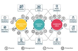 Whole Governance Picture

C.4 References
- Partnership Governance - Framework and Guidance, Manchester City Council, Issue 3, Updated December 2013
D. Process Reflection
1. Planning and Design are better evolved and expressed working in a studio format. Since most of the work is online. Coordination and scheduling of work become another big challenge.
2. Architects and Landscape architects focus on planning and design more, hence, occasional miss-management of the teamwork happens.
3. Lots of ideas, sometimes clashing with one another, so compromising or giving up on ideas is sometimes frustrating.
4. No physical experience of the coastal landscape of Brugge limits both rational and emotional connection.
5. New learnings is often accompanied by various new hurdles.
6. In city-scale projects public participation is essential, to understand the local population’s aspirations. We have no/limited participation from locals in the online format.