Pag Island
>>>back to working groups overview
| Area | Pag Island | |
| Place | Novalja | |
| Country | Croatia | |
| Topics | Tourism / Heritage | |
| Author(s) | Vedran Vuković | |

| ||
Rationale
- Why do you think this case is relevant? What is your hypothesis considering the landscape challenges?
- Format: 3-4 sentences
The rapid touristic boom, of the so called ˝party˝ tourism, over the recent decades, has exerted a lot of stress on the island landscape. Such pressures have caused a drastic change in the urban and rural patterns of the area, as well as the lifestyle of its population. This case has high significance not only on the local scale, but it is also a prime representative of a problem occurring all across the Adriatic, as well as other regions of the Mediterranean sea.
Location and scope
You can edit this map with the map editor
A Landscape System Analysis
A.1 Landscape layers and their system context
Geomorphology, landscape units and coastal typology
- Description of evolution, status quo and driving forces, is the coastal typology changing? Why is that? (approx 200 signs)
- add 1-2 graphical representations to the image gallery, you can add more if you like
Pag island consists out of a karst landscape with a lush and prosperous southern side, rich with biodiversity and human settlements, and a harsh and rocky northern side towards the land, which has often been compared to the surface of the moon. This is due to the frequent ˝Bura˝ winds that cover blow from the north-east and cause extreme erosion on the northern side of the island.
-
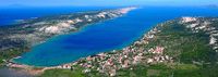 Lush south region
 -
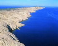 Eroded north region


Land use
- settlements, infrastructure, agriculture, resource extraction, natural areas, energy production...
- description of evolution, status quo and driving forces, is the land use likely to change? Why is that? (approx 200 signs)
- add 1-2 graphical representations to the image gallery, you can add more if you like
-
add a caption
-
add a caption
-
add a caption
Green/blue infrastructure
- What are the major potential elements of a green/blue infrastructure network? Are these likely to change/disappear? Why is that?
- You find my background material on green infrastructure in our reading list
- add 1-2 graphical representations to the image gallery, you can add more if you like
-
add a caption
-
add a caption
Actors and stakeholders
- Who is driving changes in this landscape? Who is affected by those changes?
- Draw a stakeholder and/or power map: Who is affected highly but with low power? Who has high power but is not affected?
The largest change has happened due to the efforts of the foreign investors with the end goal of promoting rapid tourism growth for financial gain. They have either purchased the land from local owners or got it under concession with the consent of the government and local authorities, to build various types of touristic infrastructure. Although the local population is the most affected party In the region, they have the least power in the decision-making process, while the tourists visiting are barely affected and hold almost no power.
-
 Power map

Sacred spaces and heritage
- Which places/elements hold cultural value and to whom?
- You may add a map and some images, please also explain in your caption why these elements are valuable
-
add a caption
-
add a caption
-
add a caption
Visual appearance and landscape narrative
- Which elements are essential for the landscape character?
- Has the landscape been painted or otherwise depicted, when and whom? Which elements are essential?
- Which narratives exist? Who has written about this landscape or depicted it in some way?
- You can add text and images
-
add a caption
-
add a caption
-
add a caption
A.2 Summary of you landscape system analysis and your development Targets
- You can summarize your findings with an DPSI(R) Model or a Spider Diagram
- Link back to the Sustainable Development Goals: Which goals are at risk?
- What is your hypothesis for this landscape?
- Visualise your hypothesis with one graphic/pict
- Are there any existing initiatives taking action in this landscape? Do you have a critical perspective on that?
- Add text and visuals
-
explain your analysis briefly in the caption
-
explain your hypthesis briefly in the caption
A.3 Theory reflection
- Reflect on at least three international policy documents in relation to their local landscape case
- choose one international, one European and one national document
- You can choose references from our reading list
- Scope: 250 words
A.4 References
- give a full list of the references you have used for this section
Phase B: Landscape Evaluation and Assessment
B.1 Assessment Strategy
- Based on the hypothesis derived from your previous landscape systems analysis you are now asked to define the goals for assessing the landscape. Your assessment is the basis for evaluating the landscape status.
- Which elements and phenomena need to be mapped, why and how?
- This a text contribution, max 250 words
B.2 Mapping
- As defined by your assessment strategy you conduct the mapping and present your findings here
- As a minimum, at least three different themes need to be mapped, you may choose more if needed
-
briefly explain the findings of your mapping
-
briefly explain the findings of your mapping
-
briefly explain the findings of your mapping
B.3 Problem definition and priority setting
- Give a summary of the major findings of your mapping process, what are the problems/potentials identified?
- Draw a problems/potentials map
- Set priorities for the most relevant issues
-
add caption here
B.4 Theory reflection
- Please reflect the assessment and evaluation methods used based on at least three readings
- Did you encounter limitations'
- 200 words test contribution
B.5 References
- give a full list of the references you have used for this section
Phase C – Strategy and Master Plan
C.1 Goal Setting
- Define strategic planning objectives based on the evaluation findings
- Link back to your original targets from section one and the Development Goals
- 150 words text contribution
C.2 Spatial Strategy and Transect
- translate your strategic goals into a vision
- develop a spatial translation of your vision
- exemplify your vision in the form of a transect with concrete interventions
- add map(s) and visualizations
-
add caption here
-
add caption here
-
add caption here
-
add caption here
C.3 From Theory of Change to Implementation
- For implementing your vision: Which partnerships are needed? Which governance model is required?
- Who needs to act and how? Draw and explain a change/process model/timeline
- Which resources are needed? On which assets can you build?
- add 150 words text and visuals
-
add caption here
-
add caption here
C.4 References
- give a full list of the references you have used for this section
D. Process Reflection
- Reflect in your intercultural and interdisciplinary team on the outcomes of your study
- Which limitations were you facing?
- What have you learnt from each other?
- What would you do differently next time?
- You can also use diagrams/visuals
- 250 words text