Pag Island
>>>back to working groups overview
| Area | Pag Island | |
| Place | Novalja | |
| Country | Croatia | |
| Topics | Tourism / Heritage | |
| Author(s) | Vedran Vuković | |

| ||
Rationale
- Why do you think this case is relevant? What is your hypothesis considering the landscape challenges?
- Format: 3-4 sentences
The rapid touristic boom, of the so called ˝party˝ tourism, over the recent decades, has exerted a lot of stress on the island landscape. Such pressures have caused a drastic change in the urban and rural patterns of the area, as well as the lifestyle of its population. This case has high significance not only on the local scale, but it is also a prime representative of a problem occurring all across the Adriatic, as well as other regions of the Mediterranean sea.
Location and scope
You can edit this map with the map editor
A Landscape System Analysis
A.1 Landscape layers and their system context
Geomorphology, landscape units and coastal typology
- Description of evolution, status quo and driving forces, is the coastal typology changing? Why is that? (approx 200 signs)
- add 1-2 graphical representations to the image gallery, you can add more if you like
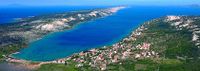
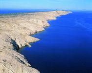
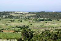
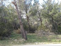
Pag island consists out of a karst landscape with a lush and prosperous southern side, rich with biodiversity and human settlements, and a harsh and rocky northern side towards the land, which has often been compared to the surface of the moon. This is due to the frequent ˝Bura˝ winds that blow from the north-east and cause extreme erosion on the northern side of the island.
-
 Lush south region
 -
 Eroded north region


Land use
- settlements, infrastructure, agriculture, resource extraction, natural areas, energy production...
- description of evolution, status quo and driving forces, is the land use likely to change? Why is that? (approx 200 signs)
- add 1-2 graphical representations to the image gallery, you can add more if you like
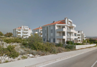
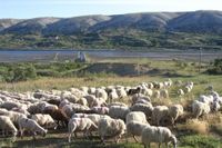
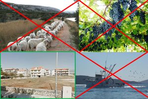
The surface of Pag island has always been predominantly covered by pastures mostly for sheep grazing, which it is famous for, also there are some agricultural areas closer to larger settlements. Due to the shift of the economy towards tourism these pastures and fields get more and more neglected and abandoned. There are dozens of smaller villages and two larger towns, which are going through a rapid urban expansion at the cost of their surrounding rural landscape. Lastly, a windfarm area exists on the highest peak off the island.
-
 Example of urban extension in Novalja
 -
 Example of Pag pastures
 -
 Novalja agricultural field
 -
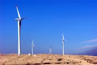 Windfarm on the island


Green/blue infrastructure
- What are the major potential elements of a green/blue infrastructure network? Are these likely to change/disappear? Why is that?
- You find my background material on green infrastructure in our reading list
- add 1-2 graphical representations to the image gallery, you can add more if you like
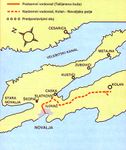
The predominant feature of the green infrastructure on the island are its pastures, which are being overgrown by invasive species due to abandonment and neglect. Also, there are numerous forest patches of the Aleppo pine scattered across and the two largest ones are situated near to Novalja and the Zrće beach. Furthermore, there are four wetland areas on the island and the most important one is the ˝Kolan mud˝, proclaimed as an ornithological reserve and is under protection as part of the Natura 2000 bird and habitat protection areas, it is 240ha in size and shown by the thickest blue line on the map.
-
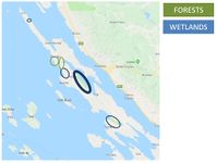 Wetlands and largest forest patches
 -
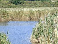 Kolan mud
 -
 Aleppo pine forest


Actors and stakeholders
- Who is driving changes in this landscape? Who is affected by those changes?
- Draw a stakeholder and/or power map: Who is affected highly but with low power? Who has high power but is not affected?
The largest change has happened due to the efforts of the foreign investors with the end goal of promoting rapid tourism growth for financial gain. They have either purchased the land from local owners or got it under concession with the consent of the government and local authorities, to build various types of touristic infrastructure. Although the local population is the most affected party In the region, they have the least power in the decision-making process, while the tourists visiting are barely affected and hold almost no power.
-
 Power map

Sacred spaces and heritage
- Which places/elements hold cultural value and to whom?
- You may add a map and some images, please also explain in your caption why these elements are valuable
The three most important historical items of the Pag island would include a Roman underground water system that was manually drilled through the underground rocks and is stretching from Novalja to Kolan mud for 1042 meters. Secondly, over a thousand years old olive gardens located next to the village of Lun, with the oldest olive tree being estimated to have around 1500 years of age. Lastly, a handmade traditional knitted lace, with a pattern unique to the island, and which was a part of the islands traditional attire. The lace is in the process of being declared as a UNESCO intangible heritage.
-
 Location of the Roman underground water system
 -
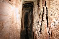 Inside of the Roman underground water system
 -
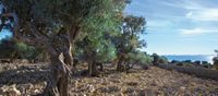 Lun olive gardens
 -
 Traditional Pag lace
 -
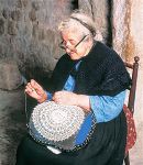 Old woman hand knitting the Pag lace
 -
 Traditional female attire of the Pag island


Visual appearance and landscape narrative
- Which elements are essential for the landscape character?
- Has the landscape been painted or otherwise depicted, when and whom? Which elements are essential?
- Which narratives exist? Who has written about this landscape or depicted it in some way?
- You can add text and images
The painting made over 40 years ago by a local resident named Borović shows the Zrće beach as calm and tranquil place know only to the local residents, while the image from nowadays shows Zrće as something completely different, an oasis for the modern party tourism. The comparison can be read as a story of absolute change in the landscape and its usage from not so long ago to today.
-
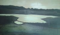 Painting of Zrće beach by Borović, 1976
 -
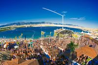 Zrće beach nowadays


A.2 Summary of you landscape system analysis and your development Targets
- You can summarize your findings with an DPSI(R) Model or a Spider Diagram
- Link back to the Sustainable Development Goals: Which goals are at risk?
- What is your hypothesis for this landscape?
- Visualise your hypothesis with one graphic/pict
- Are there any existing initiatives taking action in this landscape? Do you have a critical perspective on that?
- Add text and visuals
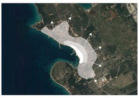
The provided map shows the are of the old town in Novalja with the full white colour, followed by an area of the initial expansion of mixed housing with some apartments as a response to the steady development a slight increase in the more family-oriented tourism at the time. The biggest area shows the recent rapid expansion of solely apartment complexes with complete disregard to the surrounding landscape and the traditional coastal building style.
If the situation continues to develop at the current rate the settlements are going to expand in such an unplanned way further, swallowing the rural landscape. The economy is going to completely shift towards tourism causing the disappearance of other economic branches and population number on the island will continue to diminish further due to the decrease of quality of life and job opportunities with the mentioned economic change.
The most endangered Sustainable Development Goals with the current development of the situation would be the goal number 8 ˝Decent work and economic growth˝, as with the development of tourism the job opportunities in other branches is declining, and the goal number 11 ˝Sustainable cities and communities˝ because this type of uncontrolled development is in no way sustainable in the long run.
-
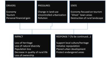 DPSIR analysis of the current situation with some possible responses to the issues

-
 Current rapid expansion of Novalja

-
 Development of touristic facilities and apartment complexes, and the abandonment of other touristic branches typical for the Pag island

A.3 Theory reflection
- Reflect on at least three international policy documents in relation to their local landscape case
- choose one international, one European and one national document
- You can choose references from our reading list
- Scope: 250 words
European Commission Maritime Spatial Planning
- Maritime Spatial Planning (MSP) is a ˝common framework for maritime spatial planning in Europe˝. It is an international initiative created in order to manage human influence and actions over the marine areas and make sure they all are performed in a cooperative and sustainable manner.
- The main positive influences that this policies hope to make is to reduce conflicts and to increase communication in-between various actors, to bring new investments into the focus areas, to increase international cooperation within various involved countries with the goal of improving the overall infrastructure of the maritime areas, and finally, to ensure better protection of the marine landscape, for both its and our own benefit.
- The directive was established in 2014, and is currently in the process the development of maritime spatial plans.
ADRIPLAN - ADRiatic Ionian maritime spatial PLANning
- ADRIPLAN is a EU-funded cross-border project as part of the Maritime Spatial Planning project. It is one of the MSP projects that are aimed at encouraging and helping the international cooperation and the application of the MSP legislative in various focus marine macro regions. ADRIPLAN is specifically aimed at the Northern Adriatic Sea and the Southern Adriatic / Northern Ionian Sea
- ADRIPLAN is of special importance to the Pag island case study due to the fact that one of the two focus regions of the project is located on the North Adriatic sea region, including the Pag island, and therefore it will hopefully prove to to highly beneficial to the examined region.
A.4 References
- give a full list of the references you have used for this section
- Google Maps
- http://web.hamradio.hr/9aff/9AFF-073_Kolansko_blato/KolanskoBlato.htm
- https://www.island-pag.net/anticki_vodovod.htm
- https://ec.europa.eu/maritimeaffairs/policy/maritime_spatial_planning_en
- http://adriplan.eu/index.php
Phase B: Landscape Evaluation and Assessment
B.1 Assessment Strategy
- Based on the hypothesis derived from your previous landscape systems analysis you are now asked to define the goals for assessing the landscape. Your assessment is the basis for evaluating the landscape status.
- Which elements and phenomena need to be mapped, why and how?
- This a text contribution, max 250 words
In the system analysis stage of the project a large number of different problems have been recognized that undoubtedly have a negative impact on the examined landscape, and these problems were synthesized in the DPSIR analysis. In the following phase of the landscape evaluation and assessment various steps will be undertaken to define those problems in more detail, to examine the value of the landscape that has been affected by them and to potentially give some pointers which could help with the development of solutions or measures for improvement in the situation.
The assessment and the evaluation of the landscape will be based on the ecosystem services approach. The process will consist out of three main categories, or steps, which by itself do not continue necessarily in a linear manner but can, and will, be revised during the process.
The first step will be to examine the observed region, determine the elements present in the landscape and the land use present. Following that, ecosystem services provided by the determined land use units will be evaluated according to their four main categories, taking into evaluation criteria the importance of the provided ecosystem services to this specific region, not their general benefit, as it may vary from one place to another. Then the land use units will be divided into five categories and mapped according to their average importance in providing ecosystem services. Finally, a rough spatial indication of potential dangers to the most valuable areas will be given along with their textual description.
B.2 Mapping
- As defined by your assessment strategy you conduct the mapping and present your findings here
- As a minimum, at least three different themes need to be mapped, you may choose more if needed
-
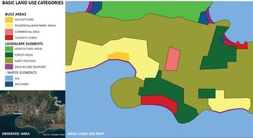 Basic land use map. The pastures in the karst landscape are of special importance to the region and take the majority of the landscape. In the urban areas the predominant surface is taken by the newly built touristic apartment complexes, somewhat intertwined with residential apartments and houses towards the central old town area.
 -
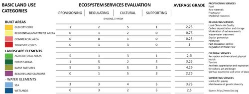 Ecosystem services evaluation. The grades are being given on the principle of how important the contribution of the land use unit in a specific category is to the region and on the overall contribution. Furthermore, evaluation is based on the importance of areas in providing various ecosystem services to this specifically examined region, and not in general, as some provided service might be significantly more important here, then in a different region.
 -
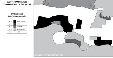 Categorization of land use units based on their importance to the region according to the average value of their ecosystem services contribution, derived from the previous evaluation. From the evaluation it is visible that the pastures are of the highest importance to the region, providing the largest variety of ecosystem services. Following them are the sea and the forests, also with very high importance, and the old town core. beaches and wetlands with medium importance. Completely opposite to that are the newly built touristic apartment complexes and the commercial district which provide almost to none ecosystem services.


B.3 Problem definition and priority setting
- Give a summary of the major findings of your mapping process, what are the problems/potentials identified?
- Draw a problems/potentials map
- Set priorities for the most relevant issues
-
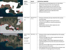 A spatial indication of potential dangers to the most valuable areas for the region, as well as their textual description. The potential dangers list has ben derived from the DPSIR analysis presented in the first part of this case study and the ecosystem services assessment from the second part.
 -
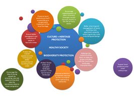 Proposed measurements and solutions that were produced as responses to the potential dangers recognized from the assessment and previously stated. The diagram is conceptualized in such a way that the central largest circle contains the basic goals that should be aimed at in the future and the surrounding circles contain a list of means to achieve this goals. These would ideally be implemented in the future design approach for the region, to ensure a healthy and thriving landscape and the local community.


B.4 Theory reflection
- Please reflect the assessment and evaluation methods used based on at least three readings
- Did you encounter limitations'
- 200 words test contribution
- The ecosystem services evaluation and assessment of the studied area has been conducted based on the data obtained from different sources, from the article by Burkhard et al. (2014) and The Food and Agriculture Organization of the United Nations (FAO) web-page. Precisely it was done according to their categorization and the description of the possible services provided in each of the four categories to get an insight into the most, and the least, valuable areas, as well as the most vulnerable ones, from the aspect of ecosystem services.
- Some limitations encountered during the assessment process would include the following. The fact that only desk research was conducted due to the inability to visit the site in person, as it is located in another country. Furthermore, the relatively short time-frame in which the project had to be done and the large scope of the studied area carrying a large number of problems to address proved to be challenging to analyse for one person working alone.
B.5 References
- give a full list of the references you have used for this section
- http://www.fao.org/ecosystem-services-biodiversity/background/en/
- Benjamin Burkhard, Marion Kandziora, Ying Hou, Felix Müller (2014), Ecosystem Service Potentials, Flows and Demands – Concepts for Spatial Localisation, Indication and Quantification
- Google Maps
Phase C – Strategy and Master Plan
The final phases of the Coland seminar, Phases C (Strategy and Master Plan) and D (Process Reflection), have been done in the collaboration with the group ´´Mohamadreza, Negar, Amirhossein, Haniyeh´´ on the Coastal Boulevard of Anzali Harbor project at the Southern Coast of the Caspian Sea, Iran.
Tho following web-link leads to the page containing the project: