COLAND Case Study 2020 - De Haan - Blankenberge
>>>back to working groups overview
Rationale
Blankenberge and De Haan are two Belgian municipalities located in the province of West Flanders. The fundamental point they share is the main development on the COAST LINE. In both cases it is one of the most crucial moments in their history. tourism.Already in the 16th century, the inhabitants of Bruges used to go to these cities for its main attraction: the beach.
The construction along the coast caused a change in the morphological structure of the cities. It was closed with high WALLS of apartment BUILDINGS are situated around the marina,
focused on the water
The presence of the north sea is important not only for tourism but also for fishing communities, which have always been part of the history of the two municipalities.
The internal part is completely destined to plots of AREA for AGRICULTURE.
This is another fundamental point of their economic growth.
However, this clear separation between coast and hinterland can cause a very strong impact and put pressure on the natural environment and cultural heritage. Thus meeting the needs of tourists, but not of the local inhabitants.
Location and scope
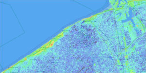
You can edit this map with the map editor
A Landscape System Analysis
A.1 Landscape layers and their system context
Geomorphology, landscape units and coastal typology
Over time, the Belgian coast has developed into a hard-engineered straight defence line from the sea inwards of flat beaches, dykes and a storm wall that is reaching its capacity limits. This coastline of the North Sea is under threat of violent marine submersion.
What was once a tidal landscape of continuously moving dunes, intruding and retracting water landscapes and meandering creeks turned into a linear system of sea and a stretch of sand, held by the urbanized dyke. Nowadays, even the polders, another result of the domestication of the sea, are invaded by the holiday driven urbanization.
Land use
In this slide an implementation plan of De Haan and Blankemberge is showed. Studying in depth the territory, residential areas are in red, while the residential expansion area is showed in a red mesh, and so on... Most predominant land uses in the case study area are ecological rural area units with comparable large residential and natural areas. Urban expansion is mainly located on the coast; this creates an extremely dense inhabited area. Urbanization is not foreseen toward the hinterland and the risk of an aggressive costal urban densification is reality.
Green/blue infrastructure
The most important and characterizing of this place is the numerous presence of small water canals that delimit the various plots of land in the large anthropized area beyond the urbanized wall, such as we’ve described in the previous slide . They are widespread throughout the area and are delimited by the kanaal gent-brugge.-Oostende and together with the meetkerke lake and the Vlissegem lake they make up the blue infrastructure of the place. While the small natural areas between the coast and the city like Duimbossen and De Kijkuit together with some small areas of uncultivated green make up the green infrastructure of the place. So you can see how the natural areas are located and develop, like a filter, sometimes, between the building and the coast, characterized by the dunes. But the most important element to underline is that the whole coast is crossed by the train line as a cut between the built and the natural.
Actors and stakeholders
Strong players in the Blankenberge and De Haan area: Mayor, City Council, Environment Department, Development Authority, State, Ministry of Environment, International Organizations. Weak actors: local businesses, local residents, tourists, and fishing communities.
In this context, international authorities have greater authority and greater responsibilities.
Local authorities have less power than international ones. Local inhabitants have less power despite having the greatest interest and effect. Despite occupying a fundamental role in the economy of blankenberge and de haan, tourists are weak actors as they are not responsible for the decisions of cities, which evolve mainly to meet their needs.About fishery sector is rather small compared to that of neighboring countries in the North Sea and has been gradually losing importance since the Second World War. It is also gradually losing importance relative to the booming tourism industry in the Belgian coastal zone. However fisheries can be an added value to the tourism experience at the coast by developing fisheries-related tourism activities.
Sacred spaces and heritage
from the historical point of view, the two cities presented a vast cultural heritage. Equipped with churches and places of interest, which are not only part of their history but are also key attractions for tourists. Church of Sint Blasius:The neoclassical Saint Blasius Church is located in a protected village. It is surrounded by a cemetery where the toads are bordered with pollarded linden trees. At the cemetery, seven British soldiers are buried. It forms an atmospheric ensemble enclosed by a whitewashed cemetery wall and wrought iron gates.
The village and the oratory of St. Blasius as the patron saint are already mentioned in 988. Archaeological research confirmed that the unsightly untouched polder village Vlissegem is one of the oldest settlements on the coast.
In the 13th - 14th century the primitive wooden church was replaced by a Gothic hall-church. This church was severely damaged during the Geuze Time (1566 - 1585) and was only partially restored due to a lack of money. By the end of 1788 the church was in such a poor building condition that the construction of a new parish church was decided. Only in 1834 the work was completed. Since then, the village owns this three-aisled church with west tower.
The sober neoclassical interior is plastered, painted white and arched by a barrel vault. A few valuable 17th- and 18th-century paintings and sculptures are preserved in the church. Most of the furniture dates back to the 18th century.
In the tourist information offices there is a brochure available called "The Holy Blasius Church of Vlissegem, a charming country church". Church of Sint Monica: Following the expansion of the Concessie estate, a new church became necessary. This prestigeous estate was designed in 1888 by the London architect William Kidner at the request of king Leopold II. It was modelled after the then-prevailing idea of English garden estates.
In 1897 the Willibrord chapel was erected on a site between Dante lane and Montaigne lane. Two years later the need for a proper church was felt and in 1902 this church was finished. Augustine monks from Ghent added a monastery at Grote street 10.
Because of further population and tourism growth this church also became too small. In 1920 architect Laenen from Schaarbeek designed a neo-Byzantine extension. The result is a church with a floor plan in the shape of a Cross of Lorraine, dedicated to Saint Monica. The patron saint is depicted in the gable above the main entrance, with the inscription "SANCTA MONICA ORA PRO NOBIS" and "ORD.S. AUGUSTINI HAAN AAN ZEE".
Through here you enter the interior of the church with a nave and 2 aisles in neogothic style, with accents of Byzantine art. The furniture remains sober and includes confessionals, offertory boxes, communion rails and Stations of the Cross. In the chancel you can observe stainglass windows depicting saints. Also, have a closer look at the Stations of the C'ross in bas-relief. The organ (1968) was built by Jos Locke and sons.
The free-standing church with a modest octagonal tower defines the view in Monica street. This short street between Wenduine road and Grote street changes into a footpath. The street was planned and laid out around the Saint Monica church together with the other surrounding streets. Some street layouts are a reminder of the former lane leading to the church and the church square. The entire Concessie estate is a protected village view. Eternity Poseidon:This statue by Xu Zhen is based on the 'Artemisian Bronze', a statue dating back from 400 BC and found in a sunken ship at the bottom of the sea in Artemisia, off the Greek coast. Until today it is unclear whether the statue represents Poseidon, the God of the Sea, or Zeus, the God of the Sky. Xu Zhen has copied the ancient sculpture and has put several components of Beijing Duck, a Chinese specialty dish, on the arms of the statue. The Beijing Duck dish has become famous in the 14th century, when it developed into a favourite of the Chinese emperors and has since been a Chinese national symbol representing Chinese culture during diplomatic banquets. In his sculpture, Xu Zhen mixes together two elements that are either at the root of the Western or Eastern culture. He acknowledges that in real life, there is a reluctance towards cultural exchange between China and Europe, caused by cultural prejudice and the fact that each side has its own fixed historical interpretations. Xu Zhen contemplates on the development of culture and civilisation that is based on mythology, and he states that historical interpretations are not as fixed as we often believe. The fact that we still don't know whether this sculpture is in fact Zeus or Poseidon is just one example that attests to the fact that a change in how we understand our own culture is always possible. This work is part of a series of sculptures, mixing Eastern and Western historical artifacts, called The Eternity Series.
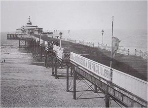
St.Antonious Church:This gothic church from the mid-14th century is a typical hall church with three naves of the same height and width. When tourism boomed in the mid-19th century, along with a strong rise in the local population, the church became too small to accommodate all the faithful during the summer seasons. A larger church was needed so a new one, the St. Rochus church, was built in 1889. BLANKENBERGE PHARE:The Blankenberge lighthouse is the main lighthouse of Blankenberge in Belgium, which also has two small harbor access lights. It is reed called the lighthouse on the Jet du Comte Jean. BLANKENBERGE PIER:The history of Pier de Blankenberge dates back to 1894. It is the oldest pier on the Atlantic coast of Europe and it is a jewel of Art Deco. The current construction, 350 meters long, was built in 1933. It replaces an older pier, dating from the Belle Époque and destroyed during the First World War. The current pier was damaged during a storm in November 2007. It dominates the entire coast, but was no longer in a very good condition.
Visual appearance and landscape narrative
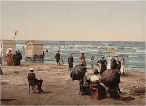
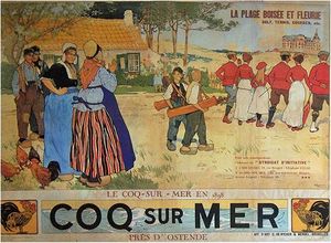
Blankenberge e de haan hanno ispirato negli anni diversi artisti,sono numeri i dipinti e le illustrazioni che la rappresentano nel suo splendore. Una delle prime immagini risale al 1890 e mostra la spiaggia di blankenberge molto affollata,probabilmente da turisti o locali che govedano della bella giornata,purtroppo l'autore è sconosciuto.La seconda immagine risale al 1894e mostra il il pier della città.Polo attrattivo importante per la città. Coq sur mer,it’s an old poster made by Henri Cassier. The last one represents the Blankenberge’s phare in 1890. Also in this case the author is unknown.
A.2 Summary of your landscape system analysis and your development targets
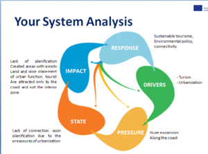
The driving forces of blankenberge and De haan are its coast and everything that has been created to enjoy it, and the tourism that derives from it. This creates an excellent basis for economic growth. These driving forces obviously create pressure on the area and therefore the worst effects are mass tourism, the urban sprawl that has occurred over the years with its consequent pollution. This affects some of the objectives of sustainable development, such as: 11. Sustainable cities and communities, 13. Climate action, 14. Underwater life, 3. Good health and well-being, Accessible and clean energy, Life on earth. There are therefore two types of impact on the landscape: a negative and a positive one. The negative impact caused the disturbance of the landscape, the pollution of the air, water and soil, the economic exploitation and the intervention of a chaotic urbanization to meet the needs of tourists have created damage to the natural morphology of the coast .. On the other hand, there are positive effects such as: the economic growth that occurs due to tourism and the global interest in the Belgian coast.
A.3 Theory reflection
At the end we present our hypothesis for the development of this area that can be divided in three points. 1) Traslate the train line far from the coast between the bult and the anthropized are; 2) De-Urbanize some settlements toward the hinterland beyong the new train line; 3) Re-naturalize the new areas and try to mitigate the impact of the city with policy of green conversion of the ground.
A.4 References
https://commons.wikimedia.org/wiki/File:De_Rycker.Coq_sur_Mer.JPG https://commons.wikimedia.org/wiki/File:Blankenberge_pier_1906.jpg https://it.wikipedia.org/wiki/File:The_lighthouse_and_villas,_Blankenberghe,_Belgium-LCCN2001697893.jpg https://www.blankenberge.be/
Phase B: Landscape Evaluation and Assessment
B.1 Assessment Strategy
The goals of our assessment can be divided in three points: Traslate the train line far from the coast between the built and the anthropized area; De-Urbanize some settlements toward the hinterland beyong the new train line; Re-naturalize the new areas and try to mitigate the impact of the city with policy of green conversion of the ground. This goals are rilevant for: Re-distribution of tourism through the focus of points of interest connected by train. Free the coast from tourist overcrowding. Planimetric reorganization of the buildings following the master plan. For this, the themes that we have tried to take up are
B.2 Mapping
Mapping of potential public spaces and religious buildings in blankenberge and de haan: the two residential areas are rich in religious buildings, which however are neglected due to the urban conformation of the cities. Our analysis aims to restore the importance of these sites and insert them into a green infrastructure system. Among the reconsidered sites is the church of Heilige Kruisvereiffing and the church of Santa Monica. They are kept in excellent condition, however they are frequented only by citizens and not by tourists as they are disconnected from the connection system. At the same time, there are also some squares where people can find monuments and statues, squares that have a certain meaning for people and that are located in the immediate vicinity of the heritage sites. Two of these squares are also located along the harbor area and reveal a beautiful panorama and scenery. We have found that many of these places are either abandoned, poorly maintained, unaccustomed to their full potential, such as where the blankenberge lighthouse is located. The latter lacks attractiveness. Some heritage sites, such as the church of st monica, which also has a small square in front, could be integrated in a system of parks or other types of green public spaces, or commemorative public spaces. The intent is to create a network in which these places can acquire the importance they deserve.
We’ve deepened our previous assessment strategy focusing on the coast and the area across that where we can see the three urban centers, from right to left, the first of them is Blanchenberge and the last two are The Haan. Now, the urban areas across coast are connected by a railway line parallel to a fast road, dividing the coast from the Hinterland together with small camping zone not present in every maps we’ve analyzed. In our opinion It’s possible localized some areas for expansion near the area just identify for the same action in the plan of the Municipalities to try to translate the camping zone. This proposal is important to stop the expansion of the cities across the coast and to obtain new areas to reconvert in natural zone. In this case, we propose a new natural park that, together with the other just present, make up a green belt with dunes and coast. In the same time, we thought at a new railway line to connect the cities, in the hinterland, so we can convert some stretches of actual road on the cost in pedestrian and cycling path.
In this slide we represented a preliminary idea of our urbanistic plan. The main issues, that we want to underline, are the interruption of the shore through the residential and touristic buildings (in red), and rural areas occupied by the camping (in yellow). Our strategy is to move the touristic activities in those “landing areas”, identified by us, (in orange mesh), nearby the residential area. The objective is to recover rural areas and to return them to the natural area. A second objective is to change the “destination of use” of all buildings along the shore in order to move the tourist attraction away and to avoid the construction of new buildings.
B.3 Problem definition and priority setting
The study area has some distinct elements that can significantly improve its development. We have broken down into potential and problems.
Among the problems we highlighted the reduction of fast connections on the coast due to a "potential": that is, the mitigation of the infrastructural barrier. the project hypothesis, in fact, plans to lighten this further barrier between the coast and the hinterland. Conceiving a change of mobility.
Entering the peripheral area in the defined system. This causes the reduction of agricultural areas,too much present in the study area.
The last point is the Reconversion of the building, This one entails an increase in urban density in the hinterland.
This would make the hinterland, now mainly made up of areas destined for cultivation or left uncultivated, to areas of new urbanization.
B.4 Theory reflection
Evaluating the area we choose some different methods: we have been studying historical and morphological aspects and observing the area through google earth. Our group chose some methods through these ones we have been to underline the most important aspects od the areas. The Landscape & Visual Impact Assessment (LVIA) method: this method helps us to understand the effects of new landscape ideas. By creating a continuous line and reopening many public areas of the terrestrial district (now still closed) the negative effects of the landscape can be reduced or avoided. Another method is the Blue Health Environmental assessment tool (BEAT), it helped us understand the impact that exposure to the sea has on the people who live there and on tourists. Furthermore, another method used was Ecosystem Services (ES). The last one gives us the possibility to study the naturalistic value of the area. This type of evaluation defines different aspects of the site, through the definition of heterogeneous factors.
B.5 References
https://www.blankenberge.be/meldingen.html https://www.dehaan.be/leven
Phase C – Strategy and Master Plan
C.1 Goal Setting
We have identify three goals: - At the first, we underline the necessity of a planning about the urban grow toward hinterland and not across the coast line, such as it seems. This goal is important to step the phenomenon we call “Urban Wall” that can divides the agriculture hinterland and the coast where are located the most important activities of the places ( fishing and tourism); - At the second goals we hope into an increase of the green belt across coast line. This point is a consequence of the first goal. The adoption of strategy planning in addiction to strategy of reconversion of peaces of settlments give us the possibility of introduce a new and free area to convert in a new natural area between Blankenberge and Harendijke, such as Duinbossen park between Harendijke and Wenduine. This goal is also important to reduce the impact of human actions on the coast to increase biodiversity, autdoor activities as wall as a natural thread between parks and sea; - At the end, our third goal, is a consequence of our first point for assessment strategy, the translation of railway line. This proposal can increase the first goal, encouraging the urban grow toward hinterland, and can be a future growt point for this two cities. The translation of actual railway line give us the possibility to convert it into pedestrian and cycling paths integrating them with an implementation of sustainable mobility towar.
C.2 Spatial Strategy and Transect
Our goals then take shape in space in this slide. Here it is represented the new zoning plan with the three residential areas in red, implemented with the new camping areas in orange and the areas returned to agriculture that filter the natural area. From the master plan below, the new cycling and pedestrian paths that follow along the coast and cut through the natural area to reach the residential area are clearly visible. However above all you can see the new route of the railway line that stops at the main junction points. In fact, the new stops and rest areas that facilitate bike sharing and reach the coast in an ecological way are fundamental.
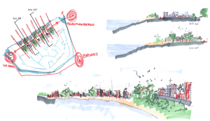
We propose a transect to analyse the relationship between the settlements of De Hann and Blankenberghe. We can see the alternation of urban landscape and natural areas. From Wenduin to Blankenberghe, passing through Duinbossen park, Harendijke and the new park of our proposal. The most important aspect to underline is the gradual rarefaction of the settlements from their core to outskirts try to integrate them with natural aspect to avoid the phenomenon of junkspaces. The points we remark are the places where we image to include our specific project such as train station in the south of settlement and the conversion of railway line in pedestrian and cycling path.
C.3 From Theory of Change to Implementation
Our goals then take shape in space in this slide. Here it is represented the new zoning plan with the three residential areas in red, implemented with the new camping areas in orange and the areas returned to agriculture that filter the natural area. From the master plan below, the new cycling and pedestrian paths that follow along the coast and cut through the natural area to reach the residential area are clearly visible. However above all you can see the new route of the railway line that stops at the main junction points. In fact, the new stops and rest areas that facilitate bike sharing and reach the coast in an ecological way are fundamental.
The phases for the realization of the project are:
- Overall analysis (preliminary) of the project area, potential and issues. - Find funding: demonstrate the feasibility and success of the idea in order to find funds. - Design and lend every detail - Environmental impact assessment: Assessment if the intervention is environmentally friendly with the context. - Development of the project with the integration of the latest ideas - Completion and realization.
C.4 References
- give a full list of the references you have used for this section
D. Process Reflection
On the basis of what has been said so far, an accurate analysis of the benefits and problems that we encountered for the choice of interventions was made. So we showed pros and cons considering multiple factors that influenced our design choice

