COLAND Case Study 2020 - Middelkerke, Team Ion Mincu
>>>back to working groups overview
| Area | Middelkerke | |
| Place | Middelkerke, West-Flanders | |
| Country | Belgium | |
| Topics | Ecosystem changes, Climate Change, public awareness, coastal infrastructure | |
| Author(s) | Alexandra Lungu, Ioana Popa, Eliza Runceanu | |

| ||
Rationale
- Why do you think this case is relevant? What is your hypothesis considering the landscape challenges?
This case is relevant because it is a seasonal tourist attraction and it has three strongly distinctive landscape patterns- semi-natural wide coastline, and artificial urban and agricultural patterns, which are affected because of people. Artificiality and existence of man brings out challenges in biodiversity, soils, water, and marine environment. The coast is most sensitive to floods, erosion, and eutrophication.
Location and scope
You can edit this map with the map editor
A Landscape System Analysis
A.1 Landscape layers and their system context
Geomorphology, landscape units and coastal typology
- The terrain forming the coat of Belgium dates back from the Holocene epoch (1.7 thousand years ago) from the Quaternary era. Due to the old age of the geological foundation and the proximity to the North Sea, most of the terrain is now underwater.
This problem was handled by the Belgium state by creating new arificial areas.


Land use
- settlements, infrastructure, agriculture, resource extraction, natural areas, energy production...
- description of evolution, status quo and driving forces, is the land use likely to change? Why is that? (approx 200 signs)
- add 1-2 graphical representations to the image gallery, you can add more if you like

Land Use Map

Green/blue infrastructure
- What are the major potential elements of a green/blue infrastructure network? Are these likely to change/disappear? Why is that?
- Green area
- Normandpark
- agricultural field
- Natural
- Blue area
- Vijver Normandpark
- North sea
- pond
One of the most dominant green/blue infrastructures at Middlekerke can be found along the coastline. The Middlekerke s beach line is the longest in Belgium. It contains sand beaches. Residents and tourists can experience nature in this way. There are a Hiking trail from Middelkerke-Westende and Statues of cartoon characters and Cinema on the beach. It may affect the infrastructures of this green and blue and it might damage the nature. Tides and storms can affect also. Normandpark is A green infrastructure in the center of Middelkerke. It is located near the beach. The pond of Normandpark was redone in a sustainable way. This area is really comfortable for enjoying the nature in the center of Middlekerke.In addition, there are lots of agricultural fields that can be considered as green infrastructure.Most of the agricultural field in Belgium is divided between barley, corn, wheat, potatoes, and vegetables and fruits and there are some areas for breeding animals.
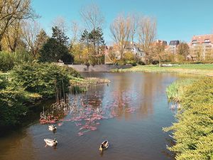
Normandpark

Green/blue infrastructures

Agricultural weekend


Actors and stakeholders
- The main actors are the Middelkerke Municipality and the West Flanders Authorities, but also the bussiness owners, the investors, the community and tourist. Each of these aactors and stakeholders have a higher or lower impact on the changes that affect Middelkerke and a higher or lower interest in what happens to the city.
- Draw a stakeholder and/or power map: Who is affected highly but with low power? Who has high power but is not affected?

Middelkerke Powermap

Sacred spaces and heritage
- Which places/elements hold cultural value and to whom?
Built environment
Middelkerke is rich by its architectural heritage. Beautiful street views have characterized the town from the 19th century. Although the town has modernized you can see the hints of the city's historic architectural value through the Townhall, Traction station, Saint Theresa Chapel and through hotels, villas and even garage. The second most important value of the place is the train connection between Knokke and De Panne. That's the reason why seaside tourism in the area has been popular since World War I. These values are important to the citizens and tourists by its beauty and formed network.
![Middelkerke Town Hall in Spermaliestraat 1. Protected building since June of 2002 in the Middelkerke Submunicipality. The eclectic Town Hall was built in 1924-1925 and is designed by architect G. Van Damme. [1]](/images/thumb/c/c9/Middelkerke_town_hall.png/195px-Middelkerke_town_hall.png)
Middelkerke Town Hall in Spermaliestraat 1. Protected building since June of 2002 in the Middelkerke Submunicipality. The eclectic Town Hall was built in 1924-1925 and is designed by architect G. Van Damme. [1]
![The Coast Tram, the longest tram line in the world, is a public transport service between Knokke and De Panne [2]. In Middelkerke there are two architectural heritage buildings in Leopldlaan street honoring the original tramline- the Tram booth [3] and Traction station. The Traction station (on the picture) is built in the early 1920s and is designed by architect Georges Vivenoy. On the facade, there can be seen an art deco impact. Traction station has been protected as a monument since October of 1995.[4]](/images/thumb/2/25/Traction_station.png/200px-Traction_station.png)
The Coast Tram, the longest tram line in the world, is a public transport service between Knokke and De Panne [2]. In Middelkerke there are two architectural heritage buildings in Leopldlaan street honoring the original tramline- the Tram booth [3] and Traction station. The Traction station (on the picture) is built in the early 1920s and is designed by architect Georges Vivenoy. On the facade, there can be seen an art deco impact. Traction station has been protected as a monument since October of 1995.[4]
![Art Nouveau style chapel of Saint Theresa is a protected building since June of 2002. The modernist north-south oriented chapel was founded in 1932-1933 and is designed by architect AV Flaubert. In the interior, there are numerous neoclassical elements, frescos and stained glass windows making the chapel an important sight to see. [5][6]](/images/thumb/c/c5/Saint_Theresa_Chapel.png/200px-Saint_Theresa_Chapel.png)
Art Nouveau style chapel of Saint Theresa is a protected building since June of 2002. The modernist north-south oriented chapel was founded in 1932-1933 and is designed by architect AV Flaubert. In the interior, there are numerous neoclassical elements, frescos and stained glass windows making the chapel an important sight to see. [5][6]
![Middelkerke is rich by its architectural heritage. There are numerous protected buildings in the style of art deco and eclectic, built in the 1920s. On the picture is an example of eclectic Hotel Continental on the Joseph Casselaan 3, Zeedijk 59. It is situated in the promenade and has a view to the sea from Zeedijk street [7]. Few of them are the style of neo-gothic and neo-Rococo, which are built around 1889-1899. [8]](/images/thumb/3/37/Architecture.png/84px-Architecture.png)
Middelkerke is rich by its architectural heritage. There are numerous protected buildings in the style of art deco and eclectic, built in the 1920s. On the picture is an example of eclectic Hotel Continental on the Joseph Casselaan 3, Zeedijk 59. It is situated in the promenade and has a view to the sea from Zeedijk street [7]. Few of them are the style of neo-gothic and neo-Rococo, which are built around 1889-1899. [8]
![Middelkerke Town Hall in Spermaliestraat 1. Protected building since June of 2002 in the Middelkerke Submunicipality. The eclectic Town Hall was built in 1924-1925 and is designed by architect G. Van Damme. [1]](/index.php?title=File:Middelkerke_town_hall.png)
![The Coast Tram, the longest tram line in the world, is a public transport service between Knokke and De Panne [2]. In Middelkerke there are two architectural heritage buildings in Leopldlaan street honoring the original tramline- the Tram booth [3] and Traction station. The Traction station (on the picture) is built in the early 1920s and is designed by architect Georges Vivenoy. On the facade, there can be seen an art deco impact. Traction station has been protected as a monument since October of 1995.[4]](/index.php?title=File:Traction_station.png)
![Art Nouveau style chapel of Saint Theresa is a protected building since June of 2002. The modernist north-south oriented chapel was founded in 1932-1933 and is designed by architect AV Flaubert. In the interior, there are numerous neoclassical elements, frescos and stained glass windows making the chapel an important sight to see. [5][6]](/index.php?title=File:Saint_Theresa_Chapel.png)
![Middelkerke is rich by its architectural heritage. There are numerous protected buildings in the style of art deco and eclectic, built in the 1920s. On the picture is an example of eclectic Hotel Continental on the Joseph Casselaan 3, Zeedijk 59. It is situated in the promenade and has a view to the sea from Zeedijk street [7]. Few of them are the style of neo-gothic and neo-Rococo, which are built around 1889-1899. [8]](/index.php?title=File:Architecture.png)
Natural environment
In Middelkerke there are three most important nature reserves- Warandeduinen, Puidebroeken, and Raversyde nature park. If Puidebroeken is important for birds, frogs, insects, and plants then Warandeduinen and Raversyde hold extra value for people's health and to the environment.

Warandeduinen nature park on the East side of Middelkerke. Puidebroeken on the South-East of Middelkerke. Raversyde nature park on the North-East of Middelkerke
![The Warandeduinen nature park is a certified nature reserve since 2003. The area size is 33 hectares big. [9]. This is a calcareous dune belt with a large and varied natural richness between Westende-Bad and Middelkerke. The area is rich by the growth of orchids [10]. Watch more photos in link: [11].](/images/thumb/b/b8/De_warandeduinen.jpg/200px-De_warandeduinen.jpg)
The Warandeduinen nature park is a certified nature reserve since 2003. The area size is 33 hectares big. [9]. This is a calcareous dune belt with a large and varied natural richness between Westende-Bad and Middelkerke. The area is rich by the growth of orchids [10]. Watch more photos in link: [11].
![The Puidebroeken (in English: Puffy Trousers) is a 14.5 hectares big nature reserve near Middelkerke. It is a protected area since 2003. [12]. The area contains mainly artificial grounds from World War I when it was used to excavate clay for the production of brick. For now it a wet meadow that has a bad water runoff. There are living numerous meadow birds, frogs, insects, and plants. The area is not freely accessible. [13]](/images/thumb/2/2a/Puffy_trousers.jpg/200px-Puffy_trousers.jpg)
The Puidebroeken (in English: Puffy Trousers) is a 14.5 hectares big nature reserve near Middelkerke. It is a protected area since 2003. [12]. The area contains mainly artificial grounds from World War I when it was used to excavate clay for the production of brick. For now it a wet meadow that has a bad water runoff. There are living numerous meadow birds, frogs, insects, and plants. The area is not freely accessible. [13]
![Raversyde Nature Park is a large landscape of water, reed fields, grasslands, meadows, plantations, and forests. It is situated in Ostend but is close to our case study Middelkerke. [14]](/images/thumb/f/fb/Raversyde_nature_park.jpg/200px-Raversyde_nature_park.jpg)
Raversyde Nature Park is a large landscape of water, reed fields, grasslands, meadows, plantations, and forests. It is situated in Ostend but is close to our case study Middelkerke. [14]

![The Warandeduinen nature park is a certified nature reserve since 2003. The area size is 33 hectares big. [9]. This is a calcareous dune belt with a large and varied natural richness between Westende-Bad and Middelkerke. The area is rich by the growth of orchids [10]. Watch more photos in link: [11].](/index.php?title=File:De_warandeduinen.jpg)
![The Puidebroeken (in English: Puffy Trousers) is a 14.5 hectares big nature reserve near Middelkerke. It is a protected area since 2003. [12]. The area contains mainly artificial grounds from World War I when it was used to excavate clay for the production of brick. For now it a wet meadow that has a bad water runoff. There are living numerous meadow birds, frogs, insects, and plants. The area is not freely accessible. [13]](/index.php?title=File:Puffy_trousers.jpg)
![Raversyde Nature Park is a large landscape of water, reed fields, grasslands, meadows, plantations, and forests. It is situated in Ostend but is close to our case study Middelkerke. [14]](/index.php?title=File:Raversyde_nature_park.jpg)
Artefacts
In between the coast of Middelkerke to Westende-Bad there are 15 bronze statues of cartoon characters and also five Beaufort monuments such as two horns (I Can Hear It) and excavator (Caterpillar 5bis), etc. These sculptures add symbolic meaning to Middelkerke's coast and town, and invites visitors to see them.
![Comic art in Middelkerke [15]](/index.php?title=File:Statues_of_cartoon_characters.jpg)
![I can hear it by Ivars Drulle. Beaufort gems in Middelkerke.[16]](/index.php?title=File:I_can_hear_it.jpg)
Visual appearance and landscape narrative
- Which elements are essential for the landscape character?
In Middelkerke, the coast and the sea play a central role. It contains sand beaches of about nine kilometers long which are connected by a boulevard and have characteristic features with its urban area and agricultural land behind. [17] [18]
- Has the landscape been painted or otherwise depicted, when and whom? Which elements are essential?
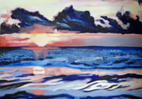
Many painters illustrated the interesting coastal landscape the colorful sea, and the nice urban view. Pierre Stefani (France, born 1938) depicted where people are enjoying in the summertime and where beach shows low sea tide. Claude Hardenne (France- 1946) depicted the colorful sea at the age of 16. [19][20]
- Which narratives exist? Who has written about this landscape or depicted it in some way?
The story of Middelkerke: Middelkerke seaside town equipped with Hotels, apartments, villas, cafes, restaurants, and beaches, as well as situated in dunes and polders. The polders perfectly suit for walks or bike and skeeters tour through an overwhelming landscape. Beach facilities and public facilities like tram are also located within the coastal area. [21] The first reference of Middelkerke is found in 1218. Before 1867 it mainly was farming settlements. One of the first world images of this area can be found on the map of the first world war by the war office and also a picture that shows the first world war in 1914 to 1918 that is taken by Chronicle. [22]
Whether to see the street view about 100 years ago and now you can see how drastically the image of the city has changed. Diverse architecture has been changed to a modern gray cubic wall, where nothing distinct.
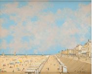
Pierre Stefani (French, born 1938)Middelkerke, the embankment and the beach at low tid

Claude Hardenne - "You wanted to see Honfleur"
Agnieszka Rozek - "Let's go to bed Middelkerke"
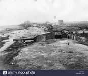
Chronicle / Alamy Stock Photo - Coastal defence battery Middelkerke, Belgium. A gun of the Cecilie coastal defence battery near Middelkerke in West Flanders, Belgium, during the First World War. - Year: 1914-1918

War Office - First World War map

Middelkerke street view, La Digue, Belgium, Flanders 1921.

Middelkerke promenade view, Les feux d' artifice, nowadays.


A.2 Summary of your landscape system analysis and your development targets

DPSI(R) Model of Middelkerke

- Link back to the Sustainable Development Goals: Which goals are at risk?
Goal 3: Good Health and Well-Being; Good health and well-being are always important for inhabitants. Because of the population growth and tourism, it is necessary to keep under control the social wealth and economy, to deal with an aging society and keep it in balance with modern worldviews. Also, more free tourism could bring problems to deal with, like diseases, cultural and safety issues, etc.
Goal 11: Sustainable Cities and Communities (Bike, walk or use public transportation); Although in Middelkerke there is a good pedestrian, bike and public transportation network near the coast it is important to keep them maintained and deal with infrastructure consciously taking in consideration that in Middelkerke the season lasts only 2-3 months.
Goal 12: Responsible Consumption and Production (recycled paper, plastic, glass, and aluminum); Due to the season lasts only 2-3 months in a year it is good to have sustainable waste development in the season and off the season. Production of single-use waste and overproduction are the things to work with.
Goal 13: Climate action; Cause the Climate Change and Global Warming is a well-known issue in all over the world, it affects also Belgium. It has to been taken into consideration that the coastal area and the town probably will be affected by floods, strong storms and winds and other changes in climate. The seasons could also be changing every year, longer autumn and spring and shorter summer and winter, etc.
Goal 14: Life Below Water; Because of agricultural chemicals, the state of water bodies is affected. Strong rains could cause eutrophication in ditches and rivers and that causes water quality to fall in connected waterbodies.
Goal 15: Life on Land; Because of the dense urban and agricultural area, the diversity of ecology is at risk. It is important to support existing biodiversity and create opportunities with greeneries to increase it.
- What is your hypothesis for this landscape?
Middelkerke is a dynamic town because of tourism. Tourism growth will affect the ecosystem because more tourism means more facilities and capacity for tourism attractions. To ensure the capacity the town needs more energy for production. More production increases the artificiality in the coast and agricultural land, and creating new and modern will lose the importance of history.
- Visualise your hypothesis with one graphic/pict

explain your hypthesis briefly in the caption

- Are there any existing initiatives taking action in this landscape? Do you have a critical perspective on that?
In the Middelkerke case is that they are not interested in keeping the nature and heritage of attraction for people. Instead, they want to keep their economy with seasonal events like Comic festival, market, and occasional music festivals. It causes seasonal overproduction and pollution which will change the environment and culture.
A.3 Theory reflection
One of the Sustainable Development Goals is Goal number 13: Climate Action, which raises awareness about the CO2 levels rising and other greenhousegases in the atmosphere and calls this a climate emergency. The Middlekerke area, being a coastal area, is one of the most affected parts because climate change causes sea levls to rise, a hotter climate, increased precipitation, a shift in seasons and extreme meteorological events. The main activity here in Middlekerke is seasonal tourism and agriculture. Both of those have a big impact for the climate change and also for the liveability of the city, therefore thorough planning must be done in order to prevent more problems to appear in the long run.
A.4 References
Sacred spaces and heritage
Agency for Heritage Heritage 2020: Town hall of Middelkerke [online] https://id.erfgoed.net/erfgoedobjects/55041 (19-02-2020)
T.T.O.-Noordzee vzw [online] http://promottonoordzee.wixsite.com/mysite/copy-of-homepage-frans (19-02-2020)
Agency for Heritage Heritage 2020: Tramway [online] https://id.erfgoed.net/erfgoedobjects/55012 (19-02-2020)
Agency for Heritage Heritage 2020: Traction Station [online] https://id.erfgoed.net/erfgoedobjects/55010 (19-02-2020)
Agency for Cultural Heritage 2020: Sint-Theresiakapel [online] https://id.erfgoed.net/erfgoedobjects/54979 (19-02-2020)
Openchurches: Sint-Theresia [online] https://openchurches.eu/en/churches/sint-theresia-middelkerke (19-02-2020)
Agency for Heritage Heritage 2020: Hotel Continental [online] https://id.erfgoed.net/erfgoedobwerpen/55054 (02-02-2020)
Agency for Heritage Heritage 2020: Heritage objects in Middlekerke [online] https://inventaris.onroerenderfgoed.be/erfgoedobjecten?deelgemeente=35011A&pagina=1&gemeente=220 (02-02-2020)
Middelkerke, family seaside resort [online] https://middelkerke.org/en/middelkerke.php (19-02-2020)
Artistic spots in Middelkerke [online] https://www.belgiancoast.co.uk/en/artistic-spots-middelkerke-westende (19-02-2020)
First World War map of Ostende [online] http://www.bl.uk/onlinegallery/onlineex/maps/europe/ww1/4801909.html (19-02-2020)
Middelkerke, la digue et la plage à marée basse [online] http://www.artnet.com/artists/pierre-stefani/middelkerke-la-digue-et-la-plage-%C3%A0-mar%C3%A9e-basse-5rjMrWUXAqr14-w8PXyu4A2 (19-02-2020)
Claude Hardenne - "T'as voulu voir Honfleur" [online] https://artenligne-littlevangogh.com/Middelkerke?fbclid=IwAR3i32N_9fOL4wKv5J-1vABIJ9njRfnkSZR3XImP4tlWq-CgYqOKcMdk_1M (19-02-2020)
Phase B: Landscape Evaluation and Assessment
B.1 Assessment Strategy
Our strategy is to evaluate the data, work and map the area, develop strategies and achieve our main goals. Those goals are the Sustainable Development Goals: - Good health and well being (Goal 3) - Sustainable cities and commnuities (Goal 11) - Climate Action (Goal 13) - Life below water (Goal 14) - Life on land (Goal 15) Through following these goals in our planning strategy we want to create a sustainable and coherent and enjoyable environment, to preserve the dverse heritage landscapes, to create flexibility to climate change and biodiversity and to offer some social and economical support to the communities. This strategy is going to focus on buildings and activities, connectivity and mobility and sustainable tourism.
B.2 Mapping
Tourism
The number of the tourists as well as the activities available are influenced by the weather and therefore by the changing of seasons. The most significant numbers of tourists, over 200 000, happen in summer, followed by spring with a number of approximately 150 000 tourists, when most outdoor activities become available. The number of the festivals is also one of the factors that lead to a higher number of tourist in summer. Taking for example the events planned for Middlekerke in 2019 we have 8 festivals in spring, 21 in summer , 3 in Autumn and 4 in Winter. Outdoor activities in Middlekerke include cycling and hiking, water sports and swimming, festivals, horse ridding and golf. The distribution of tourist accommodation along with Restaurants and Bars is uneven. Towards the coast there is a cluster of activities, whilst further into the city there are little to none. Although the activity zones are compact the diversity is not lacking. There are restaurants for any budgets, aimed mostly towards the middle class. Regarding the accommodation, there are a few options to chose from, but most of them belonging to the hostel and bed and breakfast category.

Number of tourist on the belgian coast

Tourism

Tourism classification


Connectivity
The connectivity in Middelkerke with the surrounding localities, but also the connection inside it, it generally shows medium and very good connections for public transportation such as cycling, cars, pedestrian. Public Passenger Transport has a very good connection along the coast (at sub-municipality level), also provides a direct connection with the localities that are located along the coast, connection with Westende , Nieuwpoort in the West and Oostend, Raversijde in the East. This area is provided by public transport, such as the tram line (located on the shore cliff of the coast, that is connected with the National Road N34) and bus lines 68, 69 (the route is made on the National Road N318). Although it is a well-developed from the arrangement of routes for pedestrians and cycling view, but also have been found through analysis a disruption in the area along the coast ( such as: the cyclist paths is not a unitary - linear, with interruptions in urban structure). Through the main streets are interrupted the cycling and pedestrian leads too. They have the potential of development, through the maintenance of quality streets, the creation of new pedestrian paths, continuity and maintenance of trails that exist. As regards the connection with the localities in the South Area Liffenge, Rattevale etc., the connectivity is done only by means of cars, is not served by a public transport, and alternative transport as cycling and pedestrian walk is used, but no official tracks or routes are organized for this. In Middelkerke Hinterland visiting for tourism purposes and not only to localities from South, public transportation currently is not provided.

Transport connections
Buildings and activities
The activities in the area area heavily dependent on tourism and agriculture with most commercial activities happening at the sea shore. There are only 3 schools in the area and no hospital. The closest hospital is located at 3 km outside od the city, in the north east. There is another one located in the nord-West of the city at approximately 5 km from the city. Despite the long distance between these endowments, the public transportation offers an easy solution for them to become reachable.

Buildings and activities.jpeg

Hospital location


B.3 Problem definition and priority setting
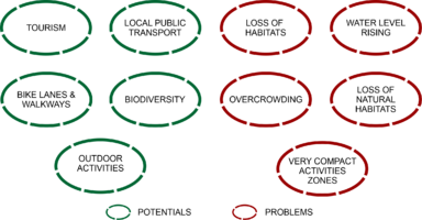
We identified a set of problems and opportunities for the Middlekerke study area. The potentials (opportunities) include tourism, local public transport, bike lanes and walkways, biodiversity and the outdoor activities available in the area. The risks (problems) include loss of habitats, water level rising, overcrowding and the fact that activity zones are compact rather than spread over a larger area. To these we can add also the risks of pollution caused by traffic and overcrowding.
Assesment Synthesis

Priorities and Targets


B.4 Theory reflection
The lack of physical access to the area was a limitation that we encountered and also the outdated materials and basemaps that may or may not be still the reality of the Middlekerke area. Another limitation was the language because most of the articles were in Dutch. But despite that, we gained major insight to the Coastal area Middlekerke. The area is mainly a seasonal tourist attraction and the infrastructure is well done and can be easily be built upon to create a more coherent system. The diveristy of the area and the tourism could be blooming with a strategical, unified planning.
B.5 References
https://www.un.org/sustainabledevelopment/sustainable-development-goals/
https://unhabitat.org/international-guidelines-on-urban-and-territorial-planning
http://habitat3.org/wp-content/uploads/NUA-English.pdf
https://climat.be/files/4214/9880/5755/NAP_EN.pdf
http://www.planeetzee.be/sites/planeetzee.be/files/public/Zeebad/20160904_presentatie%20EVQ%20VLIZ%20excursie%20Thornton%20%28deel%201%29.pdf
https://www.middelkerke.be/en/tourism
https://www.researchgate.net/publication/226620852_Coastal_flood_risks_and_seasonal_tourism_Analysing_the_effects_of_tourism_dynamics_on_casualty_calculations
Phase C – Strategy and Master Plan
C.1 Goal Setting
After evaluating information, mapping and developing strategies, we set some primary objectives such as infrastructure, continuity of tourism in the area, attracting potential inhabitants, work opportunities. These objectives will lead to the final goal of sustainable economic development and tourism. All this will make the area more profitable and new opportunities for activity through the collaboration of cultural and natural values (landscape) with infrastructure, mobility and activities. Finally, the goal incorporates important goals relevant to the area at european level.

Middlekerke goals
C.2 Spatial Strategy and Transect
- translate your strategic goals into a vision
Spatial translation of our Middlekerke vision
Our vision aims toward a Sustainable Economic and Tourist development. Because Middlekerke is heavily relying on tourism, we aimed our interventions to improve it even further without causing any damage to the local community.
Thus, our interventions include
- a series of new commercial activity areas to better serve the tourists and the local community as well
- a new hospital in order to improve the life conditions in the area, especially since there is no existing hospital in the area
- new bike lanes to further promote the sustainable approach of using eco, non motorized means of transport

Middlekerke spatial vision

Transect
Our general vision is based largely on the green infrastructure and the connectivity of the area from the inside to the outside and vice versa, and the introduction of activities inside the analyzed site.
Because Middelkerke is an area that is mostly based on tourism related activities, indoor traffic is made on the two main streets arranged on a linear shaft along the coast, (they are most commonly used by cars, having impermeable at the level of alternative access such as smooth movement and safe for pedestrians, cyclists etc. A first intervention would be the creation of pedestrian and cyclist passages and routes on the main streets, this will increase the attraction of alternative transport, and the reduction of road traffic at certain times of the day, also will encourage the preservation of the natural image of the site.
Another important point is the introduction of new activities or lack in the area also the creation of green areas that will present as green alveoli in the existing and newly created urban tissue. These infrastructure interventions, mobility will also lead to a new model of tourism, urban-rural. by creating pedestrian and cyclist routes that will unite the neighboring towns of Middelkerke.

Middlekerke transect
Accupuncture
Intervention 1 New hospital
The lack of a local hospital proves to be problematic, despite the good public transportation, so we chose to create a new hospital in the area. The location we chose for this hospital is near the city center, along one of the main roads, in order to reduce the distance between these endowments and make it easier to reach for all people no matter their location. Because Middlekerke is a coast area. there will always be cases of drowning and other accidents at sea, therefor we chose a place near the sea. Another placement criteria was to be located in an empty lot so that there is no need for demolishing.
The design is based on an ecological approach and integration with the local buildings, so that the criteria we chose was :
- to accommodate the buildings in the area
- to use local building materials
- to use renewable energy
- to use green terraces
Existent situation

After intervention

Placement criteria

Existent situation

After intervention

Design criteria


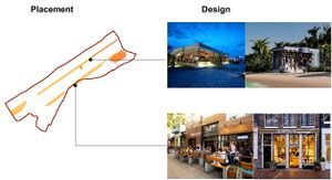
Intervention 2 New commercial activities
Middlekerke is reliant on tourism, thus, most commercial and economic activities happen at sea shore, whilst in the rest of the city there are little to no other activities. We wanted to change this and create more diversity throughout the area, so we chose to implement new activities along the main roads.
the new activities can be
- commercial, such a s small shops either for food, gifts or other non-food uses
- new restaurants and coffee shops
- tourist accommodations
- new ofice space
The design is based on the following criteria:
- to accommodate the hight of local buildings
- to use local local building material
- to use renewable energy
- accommodate to the local specific
New commercial activity areas

Types of commercial activities

Commercial activities design criteria


Intervention 3 Better mobility
On connectivity level of Middelkerke with the surrounding localities, but also the connection inside it, it will show a very good connections for public transportation such as cycling, cars, pedestrian, public transportation. At the level of connectivity, we have relied on interventions at the level of cyclist and pedestrian traffic. That will increase a comfort and security to the locals and future tourists, but also to the population that transits Middelkerke. this intervention will not only create improvements at the level of circulation and connectivity, but will create opportunities for the development of tourist activities, also will create an image of friendly environment, pleasant to visitors on the coast, as well as routes to the beach, parks inside the site and transit circulation. We have opted for a more natural framework, a mineral and natural balanced one, also it will functional as a barrier on the coast that will prevent minimum water level increase and will present a good as an urban design that it be acceptable for visitors.

Mobility
C.3 From Theory of Change to Implementation
For the partnership and governance part we laid out the governance model which is the Belgian federal government, the regulations which are provided at a regional level by the Flemish authorities and at a local level by the Middlekerke authorities, the actors comprised of west flanders authorities and those involved in the completion and development of the urban plan and those who influence, the stakeholders represented by companies, small firms, the community of middlekerke, the sponsors and tourists.
The most important sectors are the public, private and community sector and its important to explain the role each of these sectors play in our strategy. So we have the private sector which will handle delivery, marketing and funding, the public sector who has the role of handling the technology, the regulations and coordination of the strategy and the community who has the role of validating, promoting and supporting the strategy. Also we made a 20 years plan for our strategy which starts with analysis, discussion, public debates, Until the second check point there will be gathering of resources and support form volunteers and private firms. The second and third checkpoint in our strategy regards finding sponsors, agreements between public and private sectors, getting funds from European authorities, planning and goal setting. The fourth check point is implementation and adjusting the plan according to the difficulties along the way and finishing up by the last check point in 2040.

Partnerships and Governance (1)

20 years plan of action


C.4 References
http://www.compendiumcoastandsea.be/en/publications
https://www.researchgate.net/publication/230629826_Ecological_restoration_in_Flanders
https://matheo.uliege.be/bitstream/2268.2/5080/4/TFE%20viguier%20jocelyn%20final%20.pdf
https://repository.corp.at/44/
https://www.ncbi.nlm.nih.gov/books/NBK436694/
https://www.bbc.com/news/science-environment-29207644
D. Process Reflection
The lack of physical acces was a big issue because the best way to asses a situation regarding urban planning is to visit the place, but the articles and maps we found, along with very good communication between team members made all this possible. The most important factor in every team is communication and brainstorming ideas. Being able to understand and listen to one another really helped us develop the best strategy for the Middlekerke area. Also teamwork has had a positive impact on all of us because we were able to share different methods of working with one another and develop even our own skils.