Limanu-Shabla
>>>back to working groups overview
| Area | Workgroup 5: Limanu - Shabla | |
| Place | Limanu, Shabla | |
| Country | Romania | |
| Topics | Coastline study from Limanu to Shabla | |
| Author(s) | Andreea, Ionelia, Diana, Bianca, Ana Gabriela, Loredana | |

| ||
Rationale
- Why do you think this case is relevant? What is your hypothesis considering the landscape challenges?
- Format: 3-4 sentences
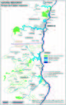
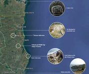
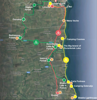
Location and scope
You can edit this map with the map editor
A Landscape System Analysis
A.1 Landscape layers and their system context
Geomorphology, landscape units and coastal typology
The southern sector of the Romanian coast, consisting mainly of cliffs formed of thick loess arranged above a discontinuous Quaternary red clay and Sarmatian limestone. There are discontinuous outcrops in the limestone base of the cliff and extending in the submerged area, forming a continuous submarine layer.
The superficial sediments on the continental shelf are distributed according to actual hydrodynamic regime while retaining sediments and numerous relict bodies. Sands are found mainly near the shore and at a depth of 30-35 m. The superficial sediments at greater depths consist predominantly of clays and silt, with relict sedimentary sand bodies. Bulgarian shelf includes in its northern part a system of underwater sea terraces and smaller underwater sandy banks with depressions between banks. The underwater coastal slope is covered mostly by rocky banks overlaid by a dynamic sandy layer. In the coastal zone down to 1.5 m depth mostly sandy deposits prevail. The nearshore underwater slope is presented mainly from limestones, sands and sandstones.
The habitats are characterized by sandbanks composed of sandy sediments in the form of deposits made up of boulders and cobbles, larger grain sizes and/or smaller grain sizes having tall shapes, oblong, rounded or irregular, permanently submerged and predominantly surrounded by deeper water. The biotopes are associated with sandbanks.
Substrate located on a solid base (hard) or sedimentary (soft), which arise from the seabed in the infralittoral and mediolitoral zone. Reefs are often associated with other habitats - permanently submerged sandbanks in shallow sections, marine caves and estuary habitats, sea arm components, and large shallow bays. In the Romanian sector of the Black Sea are present several categories of reefs. In Mangalia - Cape Aurora zone between 0 and 15 m deep, are located shallow sulfurous hydrothermal vents; in the 2 Mai - Vama Veche zone, in mediolitoral, there are rocky shores, with artificial habitats of rocks and boulders; Algal communities, brown, green and red, bivalve and shellfish populate there habitats.
-
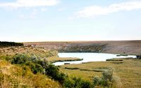
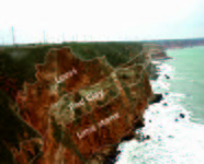 Geological layers of Limanu coast
 -
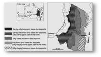 Lithologic scheme of Western Black Sea coast


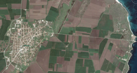
Land use
The costal concentration of tourism activities is in Limanu, where tourism investments have taken priority, resulting in a total number of 338 accommodation units. Shabla municipality is one of the least built villages and resorts (Durankulak, Krapets, Shabla and Ezerets) of the Bulgarian Black Sea coastal area and the urban tissue has not changed in the last decade, unlike the one on the Romanian seaside. The land-use includes the prevailing role of agriculture and forestry and relatively small urban use for housing, tourism, fishing and transport.
Compared to Limanu that is dependent on tourism for livelihoods, Shabla territorial unit is mainly oriented towards agricultural production. The development of Shabla economy is directed towards environmentally clean agricultural production and secondly on coastal tourism and recreation.
Other activities: beach camping, fishing activities that have suffered significant changes after 1980 in the structure of the fishing fleet and in operations because of the crisis of the resources and the new conditions of fishing in the former socialist countries, the marine aquaculture is developed only in the mollusk sector in the Bulgarian marine area, the military activities held by Romanian Navy inside and in the vicinity of the Mangalia port that affect the Mangalia marine area trough exercises for underwater operations and Shabla marine trough these military operations.
-
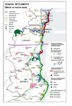 Coastal settlements effects
 -
 Vama Veche - Evolution
 -
 Shabla 2004
 -
 Shabla 2016
 -
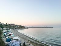 Camping in 2 Mai, July 2017


Green/blue infrastructure
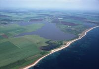
A distinctive feature of this cross-border area is the existence of natural lakes and lagoons and meadow (Mangalia Lake, Shabla-Tuzla Costal Lake, Shabla and Ezerets Costal Lakes). Shabla Tuzla Coastal Lake is located approximately 6 km east of the town of Shabla. This lake is completely separated from the sea by a sand strip. It is a salt lake – lagoon, formed mainly by infiltration of saline waters beneath the sand dunes which separate it from the sea. At some 3 km from Shabla there is also the Shabla Lake, declared a protected area in 1979. Under this name are two natural coastal lakes in Shabla and Ezerets connected by an artificial canal. They are both separated from the sea by a strip of sand, 30-50 m wide. Together with Durankulak Lake the area is among the most significant wetlands in Bulgaria.
According to the data provided by Corine Land Cover during 2006, version 2013, the broad-leaved forest occupies a restrained surface on the cross-border Limanu - Shabla area. Forests often suffer negative impacts of tourism in the form of deforestation caused by fuel wood collection and land clearing. Coastal wetlands are frequently affected by the deforestation and intensified or unsustainable use of land, drained and filled due to lack of more suitable sites for construction of tourism facilities and infrastructure. These activities can cause severe disturbance and erosion of the local ecosystem, even destruction in the long term. Aside from direct effects, such as marine and coastal pollution and the introduction of invasive species are likely to result in more fragile marine ecosystems, making them more vulnerable to other environmental impacts resulting from, for example, the coastal deforestation. Further effects of deforestation include soil erosion and coastal flooding.
-
 Forests & water bodies in the Limanu - Shabla area
 -
 Green and blue infrastructure
 -
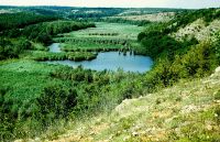
 Limanu Lake
 -
 Hagieni forest
 -
 Durankulak Lake & Forest
 -
 Shabla Lake & Forest


Actors and stakeholders
The main economic activity in Limanu area is tourism which had experienced a strong development in the last years. Thus, the area is an important market for real estate investments. Real estate developers represent an actor with a high level of impact, but who is not very affected.
In this graph are represented the types of structures of tourist reception in Limanu, Romania and the number of tourists corresponding to each type. In 2016, almost 15.000 tourists accommodated in hostels, hotels, tourists stops, school camps.
Although the local economy is encouraged, welfare of the local population is threatened (crowd, garbage, noise). Community members have a reduced impact power, but are highly affected by these changes.
The main economic functions of Shabla coastal area are agriculture & forestry and industry, followed in less importance the tourism, fisheries and nature conservation.
Agricultural fund consists in 25,000 ha of arable lands, 2,400 ha are meadows and pastures. Forest area means over 1,700 ha, mainly artificially planted for the protection of the agricultural land (about 80ha of the forests are protected forest areas). There are livestock farms, fertilizer systems, irrigation, and no livestock farms located near the coast, irrigation systems are significantly reduced. Тhere are systems for surface and underground irrigation penstocks for pumped and gravity irrigation.
Oil and Gas Exploration and Production is a sector which focuses on the area near the village Tyulenovo( 500 barrels per day (79 m3/d) in 2015).
The existing conflicts in the coastal zone are between oil and gas exploration and tourism or environmental activists. Oil and gas production and exploration may have an impact on the quality of marine water.
Fisheries are developed for the supply of the local population and tourists only. Some conflicts exist between the interests of local fishermen and the restrictions imposed on the fishing in protected areas.
In both areas, environmental activists who want protecting and maintaining the biodiversity and other natural values of the area in the long term have a reduced impact power.
-
add a caption
Sacred spaces and heritage
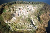
In the Limanu – Shabla area, the Bulgarian coast’s history can be traced back to 7000 years ago: near Durankulak we can find the largest prehistoric necropolis studied in the world, from the 6th and the 5th millennium BC; there are multiple burial mounds grouped in mound necropolis complexes from the Bronze Age; from the Hellenistic Age we have the ancient fortress near Shabla, the sanctuary of the goddess Cybele on the Big Island of Durankulak Lake and Thracian settlements near the village of Vaklino; from Antiquity and Middle Ages – the villages of Vaklino and Ezeretz near Durankulak, Shabla, the Caria Fortress on the site of Karon Limen near Shabla.
The settlement discovered on the Big Island near the Druankulak Lake is believed to be the first sedentary agricultural culture in Europe, which created Europe’s first stone architecture. The most recent discovered stone building has an area of more than 200 square meters and two floors which means 400 square meters of combined built-up area. On the archeological site there have also been found remains from a Thracian settlement, dating back to 1300-1200 BC, around the time of the Trojan War, a 4th century BC rock shrine of Thracian Mother Goddess Cybele and a 9th-10th century AD fortress from the First Bulgarian Empire and an Ancient necropolis.
Near Limanu we can it is located the Limanu Cave, which represents a very important field for research and discoveries for the speleologists and historians. The cave has so many ramifications and winding galleries, that resembles to labyrinth difficult to penetrate, which is also the reason why the cave is still mysterious and has a lot of secrets that haven’t yet been discovered. So far there have been discovered altars, sculptures and rupestrian paintings, rooms shaped by the hand of man, Geto-Dacian ceramic vessels.
Southern from the village of Shabla there is the Archeological Reservation Yaĭlata, where it has been revealed a ‘cave town’, consisting of 101 dwellings dating from the 5th century BC, which are said to have been used for monastic purposes. Besides that, marks of the Byzantine age have been found, as well as the remains of a fortress.
Besides the historic heritage going back to the ancient times, in the cost east to Shabla have been found numerous shipwrecks (trade and military) in the maritime space, as well as near the coast east to Limanu.
-
 historic heritage map
 -
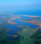
 Durakulak Lake - Big Island


Visual appearance and landscape narrative
Built by the Germans during the First World War, the Romanian coastline is studded with dozens pf dugouts, that were, after the war, strategically used in defending the coast from Cetatea Alba to Balchik, after Romania proclaimed its Independence and the harbors started to develop. After World War II, the entire defense system of the coastline was destroyed and now, the dugouts are only ruined witnesses of a long gone history. One of the dugouts is located in 2 Mai, in the Limanu commune, and the story says that here an entire squad would have died after a harsh fight and locals say that their spirits still haunt the place.
On the Bulgarian shore there is the Lighthouse at Cape Shabla, the oldest and the highest lighthouse in the country, older than 150 years and with a height of 32 m height. Painted in white and red, it protects the ships from colliding with a reef and prevents them from getting stuck in the shallows between Cape Shabla and Tyulenovo, flashing with white light three times every 25 seconds, that can be seen from 17 miles away. Locals regard the lighthouse as a smaller version of the Alexandria Lighthouse. There is also a story that more than 10 years ago, in the 1.20 meters thick walls of the building, a message has been hidden. It was to be opened by the future generations in 2056 and it contains data on the distance between the shore and the lighthouse. When it was measured, the distance was 13 meters, but according to the statistics in 1948, it was 29 meters. The guards of the lighthouse want this distance to be compared and measured in the years to come.
The coastline both in Romania and Bulgaria has always represented a subject for the landscape painting. Ion Pacea, Romanian modernist painter has been impressed by the seaside and had produced dozens of paintings inspired by the Romanian seaside, especially by the village of 2 Mai and the village of Vama Veche, in the Limanu commune. At the same time, the lighthouse in Shabla is not only important for guiding the ships, but structures the landscape and becomes subject for the artists.
-
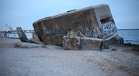 2 Mai Beach casemate
 -
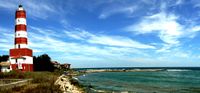 Shabla Lighthouse
 -
 Sunset at 2 Mai-Ion Pacea
 -
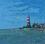 Lighthouse Shabla-Svilen Georgiev


A.2 Summary of you landscape system analysis and your development Targets
- You can summarize your findings with an DPSI(R) Model or a Spider Diagram
- Link back to the Sustainable Development Goals: Which goals are at risk?
- What is your hypothesis for this landscape?
- Visualise your hypothesis with one graphic/pict
- Are there any existing initiatives taking action in this landscape? Do you have a critical perspective on that?
- Add text and visuals
-
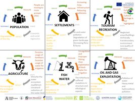 The main Drivers which influence the landscape of Limanu-Shabla are: Population, Settlements, Tourism and Recreation, Fish and Water, Oil and Gas exploitation

-
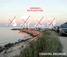 Erosion issue
 -
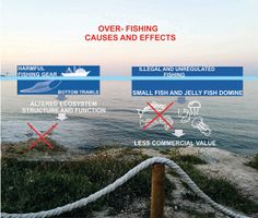 Fishing issue


A.3 Theory reflection
The main anthropogenic pressures identified on the coastal zone come from the development of the socio-economic activities: fishing, tourism, agriculture, food industry, shipping industry, construction and military activities.
Intensive fishing is a major source of ecological pressure in the area. Bottom trawling, although it is forbidden is the main fishing gear used in turbot fisheries in the coastal waters. As a result, catches of sprat in the 80's were 15-20 times higher than in the 60's.
Coastal erosion is one of the most important problems, because Shabla coast is the most actively exposed part of the Bulgarian Black Sea coast . Because of its geological character it is vulnerable and suffers constant significant losses of fertile land and natural beauty. The erosion process consists of abrasion, demolition and landsliding of the cliffs and dilution of the material and washing it into the sea. Erosion is threatening excellent beaches, the village at the coast, the coastal lands and parcels used for recreational purposes, for agriculture, for infrastructure services, the landscape values. The problem proceeds on the unprotected part of the bay, where the erosion process is very active and losses of the fertile land posse a significant threat for the local community.
The negative impacts of the erosion have significant influence on:
- Fishing - all this craft here is under constant threat of material loss and technical problems which are stopping and hindering the work of the local fishermen.
- Tourism - sites are used for tourists lodgings all the year.
- Commerce and services connected with fisheries - restaurants, hotels, camping sites, all the tourism infrastructure.
- Agriculture - loss of fertile land and the crops.
A.4 References
- http://www.marsplan.ro/images/documente/results/msp-mangalia-shabla/MSP%20Mangalia%20Shabla.pdf
- http://ziarullumina.ro/manastirea-limanu-ca-o-hozeva-dobrogeana-86323.html
- https://www.umblat.ro/evenimente-in/constanta/workshop/evaluarea-serviciilor-ecosistemice-ale-sitului-natura-2000-padurea-hagieni-cotul-vaii-73534#/
- http://neophron.com/gallery/scenery/
- http://about-eastern-europe.com/the-archeological-reservation-yailata-rezervatia-arheologica-yailata/
- http://www.imperialtransilvania.com/2018/02/12/read-more/argomenti/places-of-interest-1/articolo/limanu-cave-a-historical-labyrinth-monument-of-nature-covered-by-an-aura-of-mystery-on-the-man.html
- https://www.directbooking.ro/obiectiv-pestera-limanu-622.aspx
- https://www.saatchiart.com/art/Painting-lighthouse-Shabla-2015/809672/2617991/view
- https://www.romaniajournal.ro/the-underground-labyrinth-in-dobrogea-the-very-place-romanians-got-away-from-the-communists/
- http://www.thelivingmoon.com/46ats_members/Lisa2012/03files/Limanu_Cave.html
- https://www.natgeo.ro/natura/habitat-conservare/9855-petera-limanu-labirint-prin-istorie
- https://g1b2i3.wordpress.com/alexandru-ciucurencu-pictor-roman/ion-pacea-7-septembrie-1924-13-august-1999-pictor-roman/
- https://www.bg-guide.org/en/show-places/view/durankulak-lake
- http://archaeologyinbulgaria.com
- https://www.mirela.bg
- https://www.ziuaconstanta.ro/stiri/social/enigmele-marii-negre-epavele-din-apele-romanesti-456867.html
- https://steemit.com/travel/@victoria.tomova/durankulak-bulgaria
- http://www.wikiwand.com/ro/Litoralul_rom%C3%A2nesc
Phase B: Landscape Evaluation and Assessment
B.1 Assessment Strategy
- After applying the DPSIR method, it is understandable that agriculture, tourism and land use changes are the main drivers in the studied area.
- Agriculture because 90 % of the studied area is represented by cultures. Tourism for the high income for summer period. Land use changes due to the constructed area expansion.
- In order to have a clearer view of the main drivers the following methods will be applied: quantify the ecosystem services, analyse the risks and potentials of tourism
land use mapping and challenges.
B.2 Mapping
-
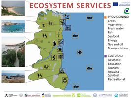 The results after quantifying the ecosystem services are comprehensible. Mainly in Limanu - Shabla area provisioning and cultural services are the most common ones. Provisioning services like crops, vegetables, fresh water, fish, seafood, energy, gas and oil, transportation are showing how valuable is the this area for people who are living in this area. Cultural ecosystem services: aesthetic, education, tourism, relaxing, spiritual, recreational. Both provisioning and cultural ecosystem services are bringing a high economic income but not only.
 -
 Being a string of resorts and a tourist attraction, the Southern Romanian coast could represent a pole for tourism development up to the highest standards. In the commune Limanu the largest amount of waste comes from tourism activities. Shabla municipality has considerable tourist resources and great potential for development that are still not used to its capacity to create income, even though one of the dominant activity in Shabla municipality is tourism. However, the main issues are the poor developed road network, because in some places there is no road access to the beaches and the sea. In Vama Veche and along the whole Bulgarian Black Sea coast, the major threat for the habitat is the eutrophication that makes the seawater opaque. Also, in the same places, the building of embankments and tourism activities (yacht ports) in the coastal area causes deterioration of the habitat. In the zone of Durankulak Lake, because of the construction of tourism facilities, some specific areas are draining, and the hydrological regime of the saline lakes has changed. The several camping sites need an infrastructure renewal and an increase of tourist places.
 -
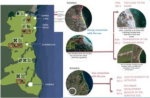 Romania and Bulgaria behave completely differently, each generating different risks starting from the location. Unfortunately, in Romania, even though it was proposed a general urban planing where clear areas of use were identified, the building demand grew and led to the construction in an abusive manner that generates two risks. First of all, building too close to the shore, ignoring the preservation of a decent clear protection limit of 100 m. What was once wanted as a linear park, was transformed into an area with permanent construction less than 40 m way from the shore. So where all of this will lead if we don’t take action? To an uncontrolled organisation that affect the natural environment. Second risk is the construction developed on the national road, which is oriented to the sea and so it destroys the perception of the landscape. Bulgaria, on the other hand, is situated at a greater distance from the sea, and even though the soil is more sensitive, the cities themselves have not expanded at all during a decade, not even in the area of the current settlements. This situation is a risk because new functions that attract tourists and people do not have a clear destination.


B.3 Problem definition and priority setting
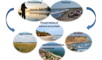
The activities that influences the Limanu-Shabla area the most are defined by tourism activities, overfishing and uncontrolled urban expansion. The most important assets in the area of Mangalia-Shabla are the Black Sea resources and the coastal resources (balneal, water, soils, minerals, etc). Fresh water is one of the most critical natural resources in the area. The tourism industry generally overuses water resources for accommodation, swimming pools, golf courses and personal use of water by tourists. This can result in water shortages and degradation of water supplies, as well as generating a greater volume of waste water. The Shabla municipality has no surface water streams. The water supply of the settlements is carried out by underground water sources built near Durankulak, Vaklino, Krapec and Shabla.
Forests often suffer negative impacts of tourism in the form of deforestation caused by fuel wood collection and land clearing. Coastal wetlands are frequently affected by the deforestation and intensified or unsustainable use of land, drained and filled due to lack of more suitable sites for construction of tourism facilities and infrastructure. The favourable geographical position of Limanu - Shabla and the proximity of the Black Sea makes the land in the area attractive for investors and real estate developmers. These activities can cause severe disturbance and erosion of the local ecosystem, even destruction in the long term.
Based on our assessments findings, we considered very important to find out a solide strategy to stop the degradation of the area and increase the development of it.
-
 Problems/risks of Limanu - Shabla area

B.4 Theory reflection
- Please reflect the assessment and evaluation methods used based on at least three readings
- Did you encounter limitations'
- 200 words test contribution
B.5 References
MSP-Mangalia-Shabla.pdf https://www.rentbyowner.com/property/lifeharbour-limanu/BC-1909912 https://www.mangalianews.ro/2014/07/sudul-litoralului-romanesc-astazi-2-mai-vama-veche-galerie-foto/ http://www.hotelroomsearch.net/city/durankulak-bulgaria http://www.mihaijurca.ro/locuri-superbe-pe-tarmul-bulgaresc-al-marii-negre-1-krapets-20-km-de-vama-veche https://www.unanhaihui.ro/plaja-ezerets-rezervatia-arheologica-yailata-bulgaria/ http://beaches.bg/en/destination/shabla-municipality/shabla-beach-near-camping-dobrudja/ http://www.aparthotelprostor.com/en/landmarks/shabla-cape-shabla-shabla-lake-ezerishko-lake-shabla-salt-lake-tuzla http://www.planwerkcluj.org/project.php?id=43 https://earth.google.com/
Phase C – Strategy and Master Plan
C.1 Goal Setting
In our study area, we consider the most relevant goals based on Development Goals.
1. Increase the quality of life: better water management, protect the aquatic ecosystem, strategic fishing, strategic usage of water for irigation, prevent the erosion of the coastal land.
2. Preservation of the natural ecosystem: connect the natural system, controlled development of tourism,create touristic facilities, develop the existing infrastructure, highlight the cultural heritage.
3. Strategic urban planning: connect the social groups in the area, attract a new flux of people, create new job opportunities, improve the local economy, break the physical disruption between the two countries.
C.2 Spatial Strategy and Transect
The main goal was that through our proposals, the two states to able to break the physical barriers between them.This will happen by connecting the natural landmarks through three routes, each route with a different character: the transit road on the Eurpean road E 87 to which are added bike lines, the touristic cultural route and the green corridor bicycle route.
The most interventions are near the sea. In 2 Mai we proposed a revitalization of the existing camping area by adding a bridge very close to the shoreline where the water level is still low and so the space can be used by users of all age in a safe environment. In Vama Veche the promenade is designed and it is an element of the protection zone. In Shabla the acces to the main touristic zone, the lighthouse, is marked and allows access to all types of users .
Of the transit route to a maximum of 5 minutes, two farms are created to host activities from which visitor can get to know Romanian and Bulgarian traditions, one located in 2 Mai and one in Vaklino.
In the north-west part there is a larger number of forests, positioned at small distances to each other and there are created small oasis of relaxation providing houses in trees, hammock areas, bicycle trails.
We create continuity by creating direct links between these spaces and through that we help the economy because by doing so, the solution contribute to the creation of more interconnected areas that make the tourism more accessible and in the end bringing more people and using multiple areas in the same time.
-
 The transect of Limanu-Shabla area
 -
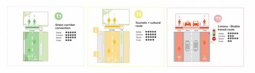 The descriptions of our routes
 -
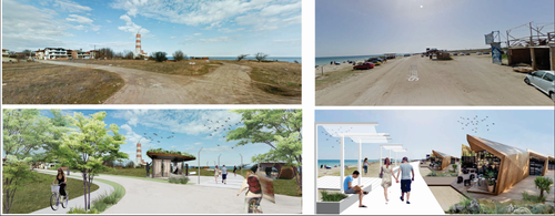 Our interventions in Shabla area - Before and After -
 -
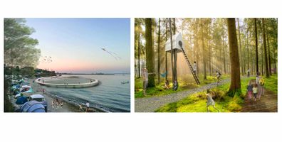 Circle bridge on the seaside in Shabla and Forest oasis


C.3 From Theory of Change to Implementation
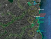
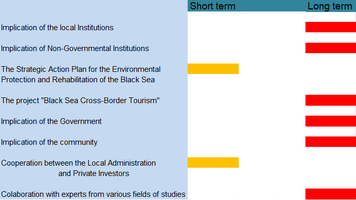
Resulting from our study, in order to a general successful development of the Limanu – Shabla area, it is necessary the implication of many actors. The most relevant actors implicated are the local institutions, the community, The ministry of regional development of Romania, The ministry of regional development of Bulgaria, The Balkan Environment Association, National Institute for Marine Research and Development "Grigore Antipa" and also the non-governmental organisations. All these actors are using the most relevant planning for helping the area to achive a sustainable development on a short , mid or long term. They had a general objective creating conditions for contacting citizens, communities and others economic actors in the border area of the two countries, in order to create a base for the economic and social development of the whole area, with benefits for both Romania, as well as for Bulgaria.
Also, the area is located on the romanian and the bulgarian coastal zone and all the activities must be related to emphasize on the common interest in stability, security and well-being mutual. From making this happened it was created the Cross - border Cooperation. It has created in order to solving common problems. It turned out to be the most advantageous approach and cross-border cooperation aims to avoid duplication efforts by the institutions of each region.
The Ministry of Regional Development of Romania and The Ministry of Regional Development of Bulgaria want to improve the regional cross - border business infrastructure and the level of accessibility to an integrated package of tourist services between Romania and Bulgaria, by establishing a Cross-border Tourism Development Center Romania – Bulgaria.
-
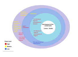 Partnerships and Government
 -
 Process model of Limanu-Shabla area


C.4 References
Marine spatial plan for the cross-border area Mangalia - Shabla
http://www.mangalia.ro/cdttrb/fckimg/file/studiu_comparativ.pdf
D. Process Reflection
Each team member is involved in different university and lives in different city or country-difficult to meet and discuss.
Taking into account the busy schedule and the activities we engage in everyday life, we are delighted that we have fully covered the requirements of this workshop. I was stimulated to find at every stage of this program the best ideas, effective and beneficial interventions for coastal areas.
There are different priorities and knowledge for each person, but we still managed coming with the solutions taking into account the wishes by each team member.
We learned from each other to have patience, to take into account the wishes of each member and to recognize what tasks everyone is able to accomplish in order to do a good job.