Miseno Lake-Capo Miseno-Baia Coast
>>>back to working groups overview
| Area | Miseno Lake-Capo Miseno-Baia Coast | |
| Place | Bacoli | |
| Country | Italy | |
| Topics | Landscape, archaeological heritage and tourism | |
| Author(s) | Chiara Pisani, Sabrina Salzano, Viviana Visone, Sergio Galano | |

| ||
Rationale
Miseno, together with all the Campi Flegrei area, is one of the most singular and authentic sites in the world for:
- Geomorphology: it is a big, still active, volcanic area (also called “super-volcano”)
- Orography: presence of hills, rocky areas (Falsie) and flat areas (bays)
- Landscape, environmental and naturalistic heritage:
                                                               Capo Miseno
                                                               Lago Miseno
                                                               Baia Park (oasi WWF)
- Archaeological heritage:
                               Archaeological Park of Baia

                               Roman theatre
                               Roman military harbour
                               Piscina Mirabilis
- Architectural heritage:
Aragonese Castle of Baia
The strength of the area is strictly linked to this factors, which have to be promoted and valorized in order to defend its identity.
-
 add a caption
 -
add a caption
-
add a caption

Location and scope
You can edit this map with the map editor
A Landscape System Analysis
A.1 Landscape layers and their system context
Geomorphology, landscape units and coastal typology
Miseno is a volcanic origin region with six volcano in state of quiescence: the most ancient (35.000-10.500 years ago) are: Capo Miseno, Porto di Miseno and the one which goes from Punta del Poggio to Centocamerelle; the new ones (10.500-8000 years ago) are: two craters called Fondi of Baia and the Baia harbor.
There are no precise information about the volcanic birth date of the site: according to some experts, it dates back to 100.000, to some others it dates back to 2 million years ago. For sure, 35.000 years ago a big eruption caused the emission of pyroclastic materials, giving birth to Campanian Ignimbrite (Grey Neapolitan Tuff) which constituted the structure of the caldera. Following to the eruption a subsidence of the Archifelgreo took place, generating volcanic lakes in some cases. Since then, there have been several others, giving birth to new monogenic craters.
From a morphological point of view, there is an alternation of high and low topographic, due to the presence of monogenic volcanic centres, partly collapsed and/or buried under the deposits of the subsequent eruption. The sea and the Braidism phenomenon (slow vertical earth movement, ascendant or descendent, due to magma’s pressure) have changed in time the morphology inducing a series of slow and inexorable transformations. The territory is mostly hilly, except for the western and southern cost and the area around Miseno Lake, which are flat.

Land use
Miseno and Baia are areas that have been colonized by ancient romans: in Miseno they built a military harbor, stores, tanks of the Piscina Mirabilis and Cento Camerelle, and a military school while Baia was exploited for the presence of thermal waters.
During the mediaeval age this area was used just for the thermal system of Baia and Pozzuoli.
From 1600 to 1900 Jewish families, expelled from Naples, stationed along roman streets.
The settlements system rapidly expanded after the Second World War, especially from 80’s on: the regeneration process involved the construction of new buildings, new streets and new public equipment. However, at the same time, the abusiveness phenomenon started taking place, not just related to residential buildings but also for commercial purposes (restaurants, hotels, bathing facilities). The wellbeing issue is not only proportional to the increase in the demand of new services, but also to the satisfaction of the existing needs (overcrowded or sick districts).
The productive activities are linked to agriculture, fishing, shipbuilding activities in Baia, small crafts. The economy is strictly linked to seasonal activities: bathing, restoration and recreational boating.
The system of public facilities responds in an adequate manner to the demand for schools and equipment of public interest but there is a big lack in green areas, parking lots and areas devoted to recreational activities (sports). Mobility is one of the crucial issues to solve: the territory faces a strong summer congestion due to the assault by the commuters; moreover, there is the necessity to provide a rapid exit route in case of natural calamities (bradisimo or volcanic eruptions).

Green/blue infrastructure
There is no existing green infrastructure but its major potential elements are linked to the connection, throughout an equipped route, of sites with naturalistic and environmental relevance (capo Miseno, Miseno Lake, Baia Park) in order to improve:
- tourism
- defense of biodiversity
- give new necessary services, linked to the living'
- reduce the hydrogeological risk with draining floor, mitigating the climate
- increase biodiversity and auto-regenerative skills
The creation of a blu infrastructure, instead, exploits rainwater collection throughout tanks and the following depuration. In this way we can get a natural resource for all the not potable uses at low price and no impoverishmentof the ecosystem.

Actors and stakeholders
The area is under the supervision of Bacoli’s municipality which developed a municipal urbanistic plan (PUC) where it analyses all the territorial functionalities, organizes the safeguarding of the natural landscape and the historical heritage valorization. Even other actors dealing with Bacoli territory have strong relevance, such as: Napoli Province, whose role is to promote a better enjoyment of the urban context through the naturalistic system. Campania Region that is working on a plan for seashore protection. The Cultural Heritage and Environmental assets authority, which draw up a Territorial Landscape Plan (PTP) for the Campi Flegrei area since Bacoli is a territory rich in history. An important role is also played by citizens who can contribute to social improvements through actively participating in the economic and social life. Considering the territorial attractiveness, even tourists are very important because they could positively affect the urban changes.

Sacred spaces and heritage
The territory of Bacoli was founded, as a holiday resort, by the ancient Romans who called it Bauli. It is an environmental landscape of exceptional historical value, and today the remains of the Cento Camerelle cisterns, the Dragonara Cave and the Piscina Mirabilis cistern, which constitute the terminal reservoir of one of the main Roman aqueducts, are preserved. Their waters come from the springs of Serino, 100 km away, up to Naples. Today the ancient cistern is open to visitors and in 2016 the site registered 11,100 visitors. Another historical relevant heritage, is the Archaeological Park of Baia, arranged on terraces called Terme di Baia. The complex originally had floors of great value. Due to bradyseism phenomenon, Baia was submerged by the sea until the 7th century AD. Among the significant remains, there are temple of Diana, of Mercury and Venu remains. With the phenomenon of bradyseism many monuments have been destroyed and still today are partly submerged, such as: The Sacellum of the Augustals, monument of the Roman era, built in the first century AD, used for the rites of worship of the emperors; The temple of Venus built in the Hadrianic period, the building is part of the spa complex. Of great value is the monument devoted to the sepulchre of Agrippa, the structure is made up of three hemicycles that have been transformed over the centuries. The emicles are connected by internal ramps. Today this monument can be visited and it is possible to appreciate closely the beauty of the good. Finally, it is possible to visit the Ninfeo of Punta Epitaffio, of the Claudian age, located there. The particularity of the territorial morphology and the phenomenon of bradyseism make the area very interesting for tourists. Baia also has the presence of an Aragonese Castle. The castle is on display of considerable strategic importance, stands on a promontory, at 51 m, naturally difficult to extreme due to caldera of volcanoes. The Castle with its strategic position becomes a domain of the Gulf of Pozzuoli up to Procida, Ischia and Cuma. The castle, built by the will of King Alfonso II of Aragon, was chosen as the site of the Archaeological Museum of the Phlegraean Fields. Along the coast, there are religious monuments such as the Church of San Sossio, the Church of S. Maria del Riposo, the Church of S.Anna Gesù and Maria and the Church of San Gioacchino. In the Flegrei camps, the tourism sector has strong potential. The analysis carried out, declare that visitor flows are in sharp growth.
-
 Piscina Mirabilis
 -
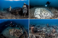 The submerged Archaeological Park of Baia
 -
 Castle of Baia, which is today the site of the Archaeological Museum of the Phlegraean Fields


Visual appearance and landscape narrative
- Which elements are essential for the landscape character?
The coast area is characterized by the color of yellow tufaceous rock, with high cliffs and volcanic craters facing the sea. This morphology favored the human -Roman and Greek - settlements by the sea, as evinced by the several archaeological remains.The sea-related activities are still a key part of the area's economy and folklore. The landscape is also characterized by local agriculture, vineyards and olive trees.
- Has the landscape been painted or otherwise depicted, when and whom? Which elements are essential?
The Phlegraean area was a key subject for local and foreign painters since the 19th century; the School of Posillipo members have often depicted the coast land, fascinated by the amenities of the place. A painting by Giacinto Gigante, "Sunset in Bacoli", was even sold by Christie's auction house.
- Which narratives exist? Who has written about this landscape or depicted it in some way?
The fascination of this "locus amaenus" digs its roots in ancient times. Capo Miseno itself is named after Misenus, Aenea's comrade in the "Eneid" by Virgilius. Plyny the Elder as well referred to the area in his "Naturalis Historiae", describing the coast between Pozzuoli and Cuma. Also Livius and others writers described the area for its thermal and residential activities.
-
 The volcanic nature of the landscape is still visible, like the remains of Capo Miseno's volcano, dated between 35.000 and 10.000 years ago.
 -
 Cape Miseno was a key spot for the Roman military activity in the Gulf of Naples. Its lighthouse is still an important reference point for local navigation. The picture shows how the surrounding vineyards have been replaced by villas.
 -
 Miseno and Baia Coast are well known residential areas since the Roman Empire, and inspired foreign painters as well. Painting by Anton Sminck Pitloo


A.2 Summary of you landscape system analysis and your development Targets
Some of 17 goals being at risk are:
- Make cities sustainable, safe, resilient
- Ensure sustainable consumption and production patterns
- Take urgent action against climate change and its impacts
In this territory, emissions produced by urban transport, electricity made, moorings during seasonal activities and primary and tertiary sector cause an increase in atmospheric pollution,
- Preserve and sustainably use oceans, seas and marine resources
Miseno Lake has been for a long time polluted by exhausts and his side’s vegetation is almost absent, exept for some episodes of Mediterranean scrub and little agricultural crops. Moreover, the abusive buildings have damaged the Borbonic wharf allowing brackish water to destroy many shrub species.
- Sustainably manage forests, combat desertification, halt and reverse land degradation, halt biodiversity loss
- Revitalize the global partnership for sustainable development
- Ensure healthy lives and promote well-being for everyone at all ages
- Build resilient infrastructure, promote sustainable industrialization and foster innovation


A.3 Theory reflection
Especially during last decades, International, European and National documents have tried to define landscape, its values and emergencies and how to protect it.
- The New urban agenda, adopted in Quito during the conference “Habitat III” looks at different goals. One of these is the environmental sustainability, reachable through a correct resource management, with an accurate territorial and urban planning, with other services and an infrastructural improvement. This is the only possible way to reduce pollution and risk of natural disasters.
- The European landscape convention (Firenze 2000) deal with landscape quality, management, and protection and enhancing a cooperation about this topic at a European level. Everyone, from citizens to landscape specialists, will have the duty to protect and to develop it. Furthermore is important a local and regional collaboration to build common programs. One of the innovation of this document is training specialists, elected representatives and technical staff of local, regional and national authorities, and the establishment of school and university courses dealing with values attached to landscape and its protection, management and planning.
- About national regulations, the “Code of cultural heritage and landscape” (2004) underlines the difference between cultural goods with a particular artistic, historic and archaeologic features, and Italian landscape, expression of millenary layering. It is important to diffuse knowledge of heritage and assure its public fruition. Collective memory is preserved by protecting and appreciating landscape.
Baia coast is characterized by a high land consumption that led to ecological fragmentation, deterioration, pollution, hydrogeological risk, neglect of agricultural areas and terraces, poor urban quality and infrastructures. So, In line with the objectives of these documents and as the plan already provides, it is necessary to protect agricultural, natural, artistic and archaeological areas, to promote tourism and public transport, make a remediation and building refurbishment.
A.4 References
- Preliminary explanatory report of the Bacoli Municipality
- https://www.coe.int/en/web/landscape/the-european-landscape-convention
- http://www.sinanet.isprambiente.it/gelso/files/decreto-legislativo-gennaio-2004.pdf
Phase B: Landscape Evaluation and Assessment
B.1 Assessment Strategy
Basing on the Landscape System Analysis of Miseno arises that the underdevelopment of the site is linked to many aspects:
- The lack of recognition by local people of the potentiality of the site
- The industrial characterization of the site (from 1950 to 1970) that brought to consider the natural and archaeological pre-existing heritage as a limit rather than a strength.
Only few years ago the cultural heritage has been seen as a real development opportunity but still now:
- The system of cultural heritage is fragmented, low promoted and devaluated
- All the cultural sites are not linked
- Touristic offer is (quantitatively and qualitatively) low developed for both hotel accommodations and related services
- There is an inefficient infrastructure system which is the cause of traffic, congestion and so pollution (environmental and acoustic) especially during summer season
The goals of the assessment analysis are be aware of the resources and the potentiality of the site:
- Green local resources: parks and local agriculture
- Blue local resources: the lake and the sea
- Archeological and architectonical heritage
- Actual and provisional threads
- Streets, circulation and links inside the area
The aim is to define a strategy of possible and sustainable development in order to transform the existing in a resource from an economic and social point of view.
B.2 Mapping
-
 The map shows presence of natural issues such as low and punctual hydraulic risk , high landslide risk and progressive costal erosion. The area is affected by water pollution caused by absuvide discharges in the lake and by port sewer.
 -
 This map shows the spread of urban fabric in agricultural areas since 1972. This happened despite the current PRG established mainly an agricultural use of these green areas. This spontaneous and illegal expansion has significantly influenced the landscape perception, the agriculture and the safety of the place too. The ecosystem services offered by these areas are cultural values (aesthetic, recreative) and supply services (food, fuel, biodiversity). Now all these factors are at risk, so it is necessary to act in order to preserve the identity of the place, protect the biodiversity and the heritage.
 -
 This map stands out a lack of the infrastructure system as there is no efficient connection between strategic sites inside the area (archeological and architectural heritage and green areas). This deficiency is the cause of traffic (especially during summer season) and so pollution


B.3 Problem definition and priority setting
-
 This graphic summarizes what are the potentials and the problems of our coast. The elements characterising Miseno and Baia’s Coast are the cultural heritage, the agriculture, the biodiversity, the geomorphology, the beaches, the landscape and the tourism. All these elements are at risk. Indeed, nowadays this territory is characterised by a high air and water’s pollution, extended phenomena of illegality and neglect, inefficient urban links, besides natural phenomena as the bradyseism, the coastal erosion, landslides risk and sea level rise.
 -
 Starting from this landscape assessment, we have tried to briefly illustrate what the necessary action are to stop all these processes. First, it is necessary an urban revitalization followed by an organization of the incoming doors (harbours, stations, parking area) and of the urban links in order to connect all the strategic points and those with particular archaeological or cultural features. There is need to improve the touristic offer both quantitatively and qualitatively and boost the agricultural.


B.4 Theory reflection
The evaluation methods considered to study such a complex topic are:
- Costal Character Assessment CCA: useful to assess the character of the coast from a visual and morphological point of view. This coastal character methodology does not prescribe the mapping of precise landward and seaward boundaries, instead relying on the judgments of professionals carrying out the assessment to identify and describe the key components of the sea and immediate hinterland which contribute to coastal character
- Ecosystem evaluation: useful to investigates the multiple benefits provided by the ecosystem to the human being. The analysis of the 4 categories identified by this method which are:
- Life support (primary production, land use)
- Supplying (food production, drinking water , materials or fuels)
- Regulation (climate and sea regulation, water depuration, control of infestation),
- Cultural values (esthetical , spiritual, educational e recreational)
let you reach a good knowledge of the main factors which contribute to identify and qualify the site in terms of resources and potentialities.
B.5 References
- http://www.greenstyle.it/storie/deforestazione
- http://www.adbcampaniacentrale2.it/
- "http://www.comune.bacoli.na.it/"
- https://www.millenniumassessment.org/en/Synthesis.html
Phase C – Strategy and Master Plan
C.1 Goal Setting
The aim of the project is to:
- Create a green line which links strategic spots (which represents the archeological and cultural heritage) throughout a green line and to distribute along it public facilities
- Incentivize biodiversity by reducing pollution and congestion throughout a ZTL (Limitated Traffic Zone)
- Protect the natural identity of the site by tearing down abusive structures
- Spread the catchment area during all the years, avoiding seasonal tourism
- Create new public spaces: squares with playground, green areas and open gym
- Requalification of Capo Miseno and Miliscola e Baia bays
The risks linked to the actuation of the project are:
- Instability of public and administrative consensus
- Weakness and slowness of bureaucracy
- Find a mediation between contrasting interests
- Find sufficient funding
C.2 Spatial Strategy and Transect
The characterizing aspects of Miseno are its geographical position (as it’s near the sea) and orography: we pass from high to low topographic, represented respectively by rocky volcanic mountains and flat lands and bays. The project areas individuated are:
- Capo Miseno: requalification
- Miliscola Bay: team down abusive bathing facilities and reduce overcrowding
- Lago Miseno: water depuration from pollution due to abusive discharges and requalification of the around area
- Rocky mountains: team down the abusive buildings which alter the perceptions of the site
- Fondi of Baia: incentivize the cultural and archeological heritage


C.3 From Theory of Change to Implementation
ACTORS
Urban planning is a complex process in which many actors are involved, each bringing particular interest. Maximize at the same time economic, social and ecological interests in not possible so it’s necessary to find a satisfying solution, an agreement between parties. The actors involved are:
- Municipality
- Park institution
- Basin authority
- Designers
- Associations
- Labor unions
- Citizen
- Private actors
HOW TO ACT
Nowadays urban planning is a co-participative process in which the involvement of citizen is fundamental as they are the one who know the living issues. The iter is the following one:
- The public institution entrusts the urban planner
- The urban planner gives a vision on the base of his lecture of the area and individuation of critical issues
- Collective discussion with citizen and the main actors involved in order to find an aan agreement to promote sustainable development
- The urban planner review the project basing on the issues emerged from the discussion in order to lead to COMMON WEALTH
GOVERNANCE MODEL AND FINANCIAL RESAURCES
In sight of the absence of sufficient public funding, the project can be financed:
- mainly by public institutions (Municipality , Province, Region)
- mainly by citizen who curios about the project and by the potentialities of its benefits, chose to give their financial contribute. This phenomena straighten the sense of community
- mainly by an agreement between public and private actors in which public gives permission to the private to build in his propriety previously unbuildable but he has the burden to finance and realize in this area mostly public facilities


C.4 References
- give a full list of the references you have used for this section
D. Process Reflection
- Reflect in your intercultural and interdisciplinary team on the outcomes of your study
- Which limitations were you facing?
- What have you learnt from each other?
- What would you do differently next time?
- You can also use diagrams/visuals
- 250 words text