Monte di Procida Coast
>>>back to working groups overview
| Area | Monte di Procida Coast | |
| Place | Monte di Procida, Naples | |
| Country | Italy | |
| Topics | Inclusive coastal landscapes: activating green and blue infrastructure for sustainable
development of the urban-land interface | |
| Author(s) | Ivan Pistone, Luca Scaffidi, Silvia Striano | |

| ||
Rationale
The area of Monte di Procida is as fascinating as it is complex because of the delicate interpenetration between its natural and anthropic aspects. Its coast is strongly characterised by a tufa ridge that has an incredible value as an essential landscape element and a symbol of the geological evolution of the site, even if it has been defaced from property speculation and illegal buildings.
However, this place is a central point in the local connection system thanks to its port activity. An environmental improvement accompanied by a project for new sustainable infrastructures could be the solution to protect this valuable area, incentivizing its development.
Location and scope
You can edit this map with the map editor
A Landscape System Analysis
A.1 Landscape layers and their system context
Geomorphology, landscape units and coastal typology
The site of Monte di Procida was generated 35000 to 10500 years ago from the collapse of the Phlegraean Fields' caldera, a semicircular depression in which a complex volcanic system rose.
During the centuries, the area of study has been constantly molded from deposits from volcanic eruptions and phenomena of erosion. In fact the coastal morphology is characterised from different layers of rock sedimentation, from the lowest and most ancient part, composed of ashes and lapilli, to the highest and most recent one, that consist of pumice and tufa from the Museum Breccia, made of large blocks of stone. Anyway, the coastline, that hosts wide sand beach of Acquamorta, is under constant threat from landslides: the Torrefumo natural oasis has the task of preserving the ridge from erosion.
Another important element of the coastal landscape system is the San Martino islet, mainly composed of pozzolana, that broke off the land in 1488 because of a seaquake.
-
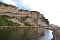 The coastal ridge of Monte di Procida with the Museum Breccia
 -
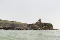 View of the San Martino islet from the sea


Land use
Dating back to the ancients, Monte di Procida is mainly dedicated to agriculture, as the rest of the Phlegraean Fields: it should be noted the importance of one of the most ancient vine in Campania that is connected to the production of the Falanghina wine, exported even to the United States.
Besides the cultivated fields, the area is quite urbanised, especially with residential buildings, even if the illegal development of the city is a serious problem that compromises its landscape value. Neverthless, tourism is still a cornerstone of the local economy.
The coast is an essential social gathering place for the citizens thanks to a coffee bar and a restaurant: it should be noted that traditional festivals are held in the harbour's area. Moreover, the coastal site attracts tourists interested in the Acquamorta beach, where they are allowed to swim, and in nature walk in the Torrefumo natural oasis, but also in visits to cultural sites: in fact the area is part of the Phlegraean Fields' Archeological Park.
Also the food business is quite developed thanks to the particular local culinary tradition, based on re-elaborated versions of American plates: the most famous is the cistecca, that is an Italian version of the cheese steak.
The road link with the neighbouring municipalities mainly comes down to the only trunk road named Via Panoramica. The Torregaveta railway station, located in the next Bacoli, allows to connect Monte di Procida with Naples, even if the main transport system is the ferry terminal that links the city with the Procida island; the dock also permits to berth a quite large number of private ships.
In the past, tufa was being mined from the coastal ridge while pozzolana was being quarried from the San Martino islet: anyway this activity gradually weakened the rock of the area, provoking a progressive landslides's risk that persisted until today. Another activity that continued until the last century was the tuna fishing, practised on the San Martino islet: even if it was quite fruitful, it stopped when the islet's isthmus was closed to the public.
Probably, in the near future, the typical activities of the area will remain more or less the same: a change of the land use would be justified by the large increase of the number of tourists. This possibility would lead to a plausible development of the transport network and in the growth of the hotel facilities and structures linked to typical local products.
-
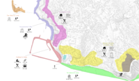 Map of the coastal area's land use
 -
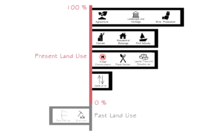 Diagram of Monte di Procida's present and past land uses
 -
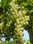 A cluster of grapes from the Falanghina vines
 -
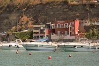 The harbour's coffee bar and restaurant
 -
 The dock of Monte di Procida used to berth ships


Green/blue infrastructure
According to the current urban plans of the area, Monte di Procida has already been involved in the project of green and blue infrastructure. In particular, the Torrefumo site has become an ecological corridor in order to preserve the high natural character of the area, improving habitats for wildlife and protecting particular ecosystems like the cane field at the bottom of the ridge; moreover, thanks to the creation of artificial reefs, it prevents the high tide from flooding the coast.
On the other side of the coast, the Acquamorta area, together with the San Martino islet, is considered a Site of Community Importance (SCI), because of its valuable role in protecting autochthonous biodiversity: in fact, according with the Network Natura 2000, its main target is to keep the best conservation status of habitats and species of Community interest.
It seems advisable the extension of the abovementioned green infrastructures in order to intertwine the ecological spaces with the harbour area: this could enhance the multifunctional potential of the site, channeling all the port's uses in a single system and improving the suggestive Monte di Procida's landscape.
It is unlikely that this ecological systems are going to disappear in the near future, even if they could probably evolve in order to increase the advantages that this way of planning generates for both urban and natural sides of area of research, creating a greener and more attractive city and giving landscape the appropriate permeability.
-
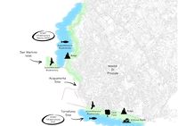 Green infrastructures in Monte di Procida
 -
 Existing systems in the coastal area: the harbour's zone lies between two green infrastructures


Actors and stakeholders
The area of study is managed by the Municipality of Monte di Procida that is currently drafting a new town planning project (P.U.C.) in order to analyse in operational terms the safety and the functional organisation of the territory as well as the preservation of its landscape, architectural and archeological features.
Other actors in this place are the Province of Naples, that promotes a connection between the human settlement and the natural system at a provincial level, the Campania Region, that is working on a plan for coast defence.
Also it should be noted the importance of the Superintendence for the Environmental and Architectural Heritage of Naples, that has drawn up the Piano Paesistico Territoriale dei Campi Flegrei (P.T.P.), giving instructions for the full protection and landscape restore of Monte di Procida's ridge, and the Basin Authority is drafting a plan against the coastal erosion (Piani Stralcio per l'Erosione Costiera) in order to identify the high-risk areas and introduce guidelines for intervention.
Even the small businesses (especially bars, restaurants and tourist accomodations) and the simple citizens of the place are essential stakeholders because they actively partecipate in the social and economic life of the city. In this sense, a contribution is given by foreign investors, in particular from the United States, because of the high number of immigrants from Monte di Procida.
The tourists could be considered as actors in this system too: they have not a particular power of decison in the development of Monte di Procida, even if thay are not pretty much affected by the urban changes.
Finally, the operators of the port activity can be considered traditional stakeholders of the coastal zone, because of the deep connection between the city and this transport system providing for the most part of the movements of both tourists and citizens.
-
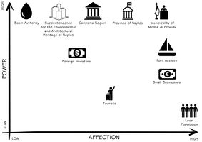 Power map showing the stakeholders of the area

Sacred spaces and heritage
Monte di Procida was probably founded in the VI century before Christ and its ancient origins are linked to the histoty of Cuma and Miseno: in fact, the study area has been part of both the abovementioned cities, before it was colonised by the settlers from Procida during the XVII century. Their first church, the so-called Chiesa della Madonna Assunta, goes back to this period and it is still an important local place of worship.
Another essential sacred space is the cemetery, that hosts also the remains of the immigrants in the United States. It is surrounded by the trees and its relationship to nature makes it similar to a spiritual place, non unlike the English graveyards; moreover, it is a highly panoramic spot.
The archeological side of the city is just as interesting. Monte di Procida is crossed by various historic and scenic path connected to ancient trade routes, in fact there is a compex of hypogeum catacombs along the road that links Miseno and Cuma, in particular in the area of Cappella: the tombs, artistically remarkable, were built for the sailors of the Miseno fleet.
-
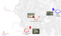 Map of the sacred spaces and cultural heritage in Monte di Procida
 -
 Chiesa della Madonna Assunta
 -
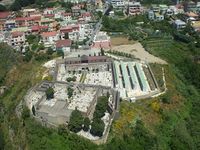 Aerial view of the cemetery of Monte di Procida
 -
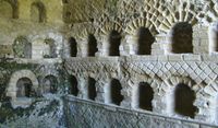 The Roman necropolis of Cappella


Visual appearance and landscape narrative
Monte di Procida is an ancient location in the Phlegrean area that can be related to the Indoeuropeans’ invasions era. Thanks to its favorable position, it has always been an important commercial pole. Its major harbour was Acquamorta that also allowed movements of the Cumaean and Syracuse fleets. The name Monte di Procida derives from the defeat of Miseno by Barbarians’ invasions: after this loss the administration joined the Procida’s one, that's why it is called Monte di Procida.
Acquamorta’s beach is one of the most attractive place in Monte di Procida, its name is closely related to an ancient legend.The story says that a young and beautiful girl, named Acqua, used to escape from his father’s psychological pressures by coming to the beach to find some peace and swim. One day, further from the coast, she was actually going to drown, but a young fisherman from Procida saved her. From that day the young fisherman docked with his boat right there, near the beach, just to see that young and beautiful girl named Acqua. Someday, the fisherman, did not come anymore to the beach, rumors say that he died in a storm. Heartbroken, the young and beautiful Acqua could not live anymore without her eternal love, so she decided to throw herself into the sea and die, hoping to meet again her lover. No body was found, so from that day the beach was named “Acqua morta”, in memory of that girl who killed herself for love.
Monte di Procida throughout the years has been a destination expecially for couples, for its magnificent view. We don’t have a large historical testimony, but there are some paintings that portray the area. For example there is a painting by August Wihlem Julius Ahlhorn, located to the National Gallery of Berlin, dating 1832: from this one we can admire Pozzuoli, Bacoli and finally Monte di Procida.
Another painting was made by Pietro Fabris – a painter that worked in Naples from 1754 to 1808 – who shows us in his work the Pozzuoli’s gulf, with Nisida’s island, Bacoli, Capo Miseno and on the back Monte di Procida.
-
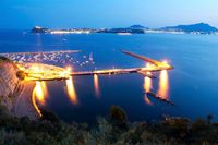 View of Acquamorta's Bay: it is one of the most distinctive place of Monte di Procida
 -
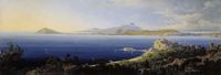 August Wihlem Julius Ahlhorn, Pozzuoli Bay with Bacoli and Monte di Procida, 1832: it is evident the spatial connection between the two places
 -
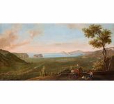 Pietro Fabris, Veduta del Golfo di Pozzuoli: Monte di Procida is visible in the background


A.2 Summary of you landscape system analysis and your development Targets
With reference to the Sustainable Development Goals, laid down in 2015, some important social and environmental targets are actually at risk in the area of Monte di Procida.
- Goal 9: Build resilient infrastructure, promote sustainable industrialization and foster innovation - Investments on the transport infrastructure network would be an important element for the deveopment of the site: in fact, nowadays the road and rail links are underdeveloped, while the port activity would be increased with appropriate infrastructure projects.
- Goal 10: Reduce inequality within and among countries - Monte di Procida could esponentially increase its wealth thanks to many factors, as the further growth of the tourist industry: until then, there will be a moneyed social class at the expence of the rest of the population that will not benefit from the potential of the city.
- Goal 11: Make cities inclusive, safe, resilient and sustainable - Strengthening the urban system would bring substantial benefits to the population, not only in economical terms but also at a landscape level: this course of action could halt the abusive construction practices that damage both the visual perception of the coastal ridge and its environmental integrity endangering the whole area.
- Goal 14: Conserve and sustainably use the oceans, seas and marine resources - The Phlegraean area's seas have always been an important ecosystem for various species; the polluted waters caused by a heavy naval activity could alter the delicate balance of the Monte di Procida's sea and coast.
- Goal 15: Sustainably manage forests, combat desertification, halt and reverse land degradation, halt biodiversity loss - The anthropic development has put at risk also the land's biodiversity, degrading the vegetation that follows the coastline and the characteristic tufa ridge.
In accordance with the above reasoning, the coastal area is suscettible to be transformed, in the future, due to environmental and hydrogeological changes: in fact the high tide and the risk of landslides could redesign the coastline in a negative way, reducing the actual space to put into different land uses. The illegal construction is another plausible cause for the coast's future change: the further proliferation of the land speculation could affect the visual landscape coherence, risking also the integrity of the ridge and damaging the local ecosystem. Nevertheless, the Acquamorta and Torrefumo's green infrastructures give a substantial positive contribution to the system, mitigating the disaster's risk and cushioning the anthropic impact on the landscape.
Nowadays, there are some initiatives that are designed to preserve the coast and its ecosystem, like the plans drafted up by the Campania Region and the Basin Authority,as indicated above: in this projects, the landscape enhancement is combined with a methodologic and operational approach against the natural risks, as the abovementioned landslides.
Even if this initiatives have a great importance for the area, they have been probably adopted too late to be immediately effective, in fact, during the last years, there have been already some landslides in the coastal site. For this reason, the local administration will have to make a huge effort in order to apply the introduced legislation.
-
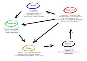 Monte di Procida's economic structure depends on the port activity, significantly related to the tourist industry, and on agricultural products, especially wine. Anyway the environmental pollution and the critical situation of the coastal ridge, together with the proliferation illegal construction and a progressive sea level rise, have led the area to a state of dirty waters and beach near the harbour and Acquamorta and in limited but dangerous landslides along the coast. As a result, investors and tourist are gradually losing their interest in the city, while the local ecosystem is at risk. In order to counter these impacts, various plans for safeguarding the environment have been approved; moreover, artifical reefs and systems to clean waters have been designed

-
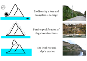 The driving force are leading the area to three main environmental consequeces. A biodiversity's loss will follow the ecosystem's damage caused by climate change and pollution: this will result in a rise in sea levels; moreover, the coast will face the effects of the erosion with a consequent increase of the landslides' risk. Lastly the arbitrary and illegal buildings will contribute decisively to alter the landscape perception and structure

A.3 Theory reflection
The coastal emergency is deeply connected with landscape preservation of Monte di Procida: these topics have been examined in depth through the years by different documents.
The international New Urban Agenda focuses on the bad planning that defines present cities, like Monte di Procida, the consequence of which is a low-quality land management. The coast of the area of research is under threat from illegal constructions that preclude a functional usability of the site, from sea pollution that limits the tourist and enviromental development and from the high risk of landslides. The New Urban Agenda advocates the correlation between good urbanization and sustainable development, showing the importance of a real collaboration between the different layers of political government but also, at a local level, a cleverer resources' management in order to preserve the landscape values and the cultural heritage with efficient infrastructures, making Monte di Procida a more attractive and liveable city.
At a European level, the Maritime Spatial Planning European Strategy for more Growth and Jobs in Coastal and Maritime Tourism higlights how the waters need to be managed in the most efficient way in order to conduct the human activities safely and sustainably for the sea: for this reason, the European Parliament has signed in 2014 a legislation for maritime spatial planning. In the study area, according to these rules, the conflicts between different sectors, like the local small businesses and the tourist infrastructures, should be reduced, increasing the cooperation between them and encouraging investment in order to enhance sustainable economic growth: this would lead to an early identification of impact and opportunities for multiple use of space, protecting the environment.
In Italy, the Code of Cultural Heritage and Landscape (2004) describes landscape as an area that represents a place through the interrelationship between human and natural factors. This description perfectly matches the study area that may be enhanced through the promotion of the cultural development, in accordance with the protection values. In this way, the coast could be coherently included in projects aimed at restoring the ridge while promoting the realisation of green infrastructures that could strenghten the landscape values, channeling the multifunctional nature of the site. Moreover, every administrative body should give its contirbution within the limits of its powers: in this sense, institutions like the Campania Region and the Basin Authority are already working on drafting plans to safeguard the environment and its landscape features.
A.4 References
- Una passeggiata lungo la costa di Monte di Procida e non solo...
- Comune di Monte di Procida
- PUC, RUEC e Rapporto Ambientale per la Valutazione Ambientale Strategica
- Building a Green Infrastructure for Europe
- Towards a Green Infrastructure for Europe. Developing new concepts for integrations of Natura 2000 network into a broader countryside
- Difesa delle Coste
- La storia di Monte di Procida
- Parco archeologico dei Campi Flegrei - Necropoli di Cappella
- Monte di Procida e la leggenda di Acquamorta
- Dipinti antichi
- Un dipinto con vista da Pozzuoli con Bacoli e Monte di Procida del 1832 esposto al National Gallery Berlin
- Sustainable Development Goals
- New Urban Agenda
- Maritime Spatial Planning European Strategy for more Growth and Jobs in Coastal and Maritime Tourism
- Codice dei beni culturali e del paesaggio, ai sensi dell'articolo 10 Legge 6 luglio 2002, n. 137
Phase B: Landscape Evaluation and Assessment
B.1 Assessment Strategy
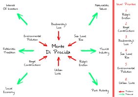
Basing on the Landscape System Analysis of Monte di Procida, the loss of biodiveristy and the ecosystem damage, the illegal constructions, the sea level rise and the ridge’s erosion are the most substantial problems that need to be solved in this area.
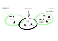
Referring to those problems the goals that may fit Monte di Procida's assessment are easily synthesizable in
1. Quantify the impact of the anthropic elements on the natural system with a multilayer approach, in accordance with the previous analysis of the site
2. Evaluate the level of risk that threatens the potentials of the site, studying which problems are responsible for its present condition
3. Systemize the first two points in order to create a database useful to design a sustainable project strategy for the Monte di Procida's coastal area
Those points are strictly related to each other and that’s why all the focal points are also connected to almost all of the three goals.
First of all it is possibile to talk about the natural aspects of the area, beacause, as said before, there’s an emergency referred to the loss of biodiversity, the quality of human living and the strong local culture. On the other hand, it is important to talk about the increase of portual activity, paying attention to the first point and being respectful towards natural areas. Because of this last point, there must be a lens on the risks that may be connected to both the systems up there specified. Last but not least, the ultimate point are the Ecosystem Services referred to the area, because these gives a better lecture of the site, letting people handle and plan to the best.
B.2 Mapping
The study case presents a certain complexity in its structure. It is therefore essential to organize all these aspects in order to catch their importance and connections.
-
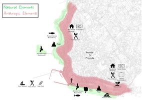 Natural and Anthropic Elements. The site is characterised by various elements, both anthropic and natural: these different systems define two bands that develp close to the coast, keeping a mutual connection between them even without phisically intertwining
 -
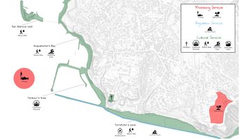 Ecosystem Services. The study highlights the structure of some particular aspects. The provisioning services comes down to a single important sector, that is linked to food, especially agriculure and, in lesser quantities, fishing; the same applies to the regulating services that mainly refer to the flood regulation performed by the existing artificial reefs. The cultural services touch more domains: the aesthetic sector focuses on landscape and naturalistic value, situated in the Torrefumo and Acquamorta's areas; the spiritual aspect refers to the cemetery on the ridge; in th end, the recreational sector is connected to nature walks, swimming areas and folkloristic traditions
 -
 Risks and values. The area has various factors that enhance its value, like the natural and touristic relevance. Anyway there are several risks that put these potentials in danger, especially connected to the illegal constructions but also to natural disasters, like landslides of the ridge and the gradual sea level rise: this kind of problems can seriously damage not only the economic side of the area but also its wealth of biodiversity


B.3 Problem definition and priority setting
The most dangerous threat of the area could be considered the ridge's erosion because it is not only linked to the landscape perception, but it also concerns the question of safeguarding the life of the citizens. From this perspective, the illegal constructions aggravate the abovementioned issue. Moreover, the biodiverstiy's loss can be related to these problems, even if the natural ecosystem is harmed also by the sea level rise and by the growing pollution of the environment.
Anyway, the coast has various important potentials that colud make this zone one of the spearheads of the recovery of the whole Phlegraean area, like the interest of tourists and investors justified by the Monte di Procida's naturalistic values and by the rising local economy. Of course, the port activity is still a fundamental element of the entire urban system, even if the city doesn't have many other significant connections with the territory.
It can be seen, therefore, that both anthropic and natural aspects play an important role in the Monte di Procida's scene, giving various suggestions for a feasible project of the coastal area.
-
 Result of the assessment and priority setting of the problems
 -
 Main goals for the planning design process


B.4 Theory reflection
The assessment of the area was brought forward in order to give the broadest possible perspective on the site's complexity, in accordance with some important readings about evaluation methods.
The Ecosystem Services (ES) method makes possible to study the naturalistic value of the area for its population, giving various resons for sustainable management of ecosystems. This kind of assessment defines different aspects of the site, mapping heterogeneous factors of the Monte di Procida's system, both risks for ecosystem health and potentials to provide a service, avoiding harmful impacts on the landscape: anyway, it was difficult to identify the local functional elements because they haven't clearly defined boundaries.
Considering the coastal area of Monte di Procida as a blue infrastructure, the BlueHealth Environmental Assessment Tool (BEAT) could quantify the impacts on popoulation and on landscape health. Although this tool wasn't effectively used, following its principles, the site was evaluated integrating different domains, exploring its social, ecological and anthropic sides. The information gathered were consolidated in an objective assessment, even if the collection of the abovementioned information was hampered by the citizens and local authorities' reticence.
The evaluation of the study case pursued also the ideals of the Habitat Appraisals (HA) because of the strong link between Monte di Procida and the Natura 2000 project. This approach helped to search a way to minimize the environmental impact, studying at the same time different solutions that could be combined with the ongoing design process of the area, drawing on the strenghts of the SCI sites on the coast in order to preserve the important indigenous biodiversity and to defend the ridge's integrity. In this case, the limitations concern the intentions of the existing plans that are not always clear, because these projects are still in a drafting stage.
B.5 References
- Mapping Ecosystem Services
- BlueHealth environmental assessment tool (BEAT)
- Assessment of plans and projects significantly affecting Natura 2000 sites
Phase C – Strategy and Master Plan
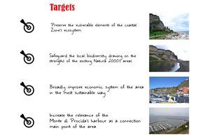
C.1 Goal Setting
The coastal area of Monte di Procida’s evaluation findings have led to four objectives that aim to a sustainable local regeneration. The planning hypothesis tries to actively interface with the abovementioned Sustainable Development Goals in order to act in a targeted and effective way where it matters most. According to the studies carried out, four strategic planning objectives have been designed.
- Designing a sustainable marine station, that could become a local landmark, included in a new public square for redistributing the social and commercial functions of the area, increasing, increasing the influx of people and, consequently, the economic possibilities. This objective is linked to the Goal 9: Build resilient infrastructure, promote sustainable industrialization and foster innovation
- Creating an effective retaining wall in order to prevent landslides where the risk is higher, especially between the two Natura 2000's zones of Acquamorta and Torrefumo: in fact, in the port area, there is the highest number of human activities; moreover, there is a reduced quantity of vegetation, that could avoid the ridge's collapse, and there is the majority of the illegal constructions that instead undermine its integrity. This objective is linked to the Goal 15: Sustainably manage forests, combat desertification, halt and reverse land degradation, halt biodiversity loss
- Enhancing the urban system by means of economics and legislation, encouraging the growth of local economy and tourist industry close to the coastal study area, going deeper into the rules to put a stop to further illegal constructions at the same time: this could be a solution for raising the local wealth in a more on a wide-spread basis in all social classes and for preserving the visual perception and the integrity of the coastal ridge. This objective is linked to the Goal 10: Reduce inequality within and among countries and to the Goal 11: Make cities inclusive, safe, resilient and sustainable
- Improving the existing Natura 2000's zones, creating new elements to preserve the local biodiversity (like more artifical reefs against the dangerous sea level rise or wire mesh against landslides), but also to keep the marine ecosystem intact (like sustainable water treatment plants against the pollution); moreover, the abovementioned areas could be integrated with sustainable small interventions like removable catwalks and benches to allow the visitors to reach and get across these spaces in an easier way, allowing them to swim where it is possible. This objective is linked to the Goal 14: Conserve and sustainably use the oceans, seas and marine resources and to the Goal 15: Sustainably manage forests, combat desertification, halt and reverse land degradation, halt biodiversity loss
C.2 Spatial Strategy and Transect
The coastal area of Monte di Procida could be seen as a deeply scenic and potentially multifunctional entry to the city: it welcomes the citizens and the tourists in its harbour, since Roman times, enveloping their sight with its characteristic ridge, like a kind of Phlegraean Pillars of Hercules; it is the focal point for the community that is reflected in this place linked to ancient traditions; it is connected with the most important local economic sectors, especially the tourist industry, largely bound to the naturalistic side of the coast, and the maritime transport, essential and hystorical connection point for the entire Phlegraean Fields. Based on these considerations, it is important to build, figuratively and materially, a New door for Monte di Procida in order to embody all these traditional and rooted forces in a sustainable, modern functional reimaging. In this way, the abovementioned objectives can be justified for preventing further damages to the landscape perception of the area, related to the economic power of the tourism and of the investors, encouraging an economic recovery that would put an important urban centre in its rightful place.
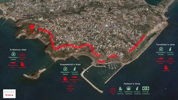
The definition of the project relates to the use of the transect's technique, based on the physical form of the built and natural environment of the area, in order to identify local potentials and connecting them in the most sustainable and effective way with a common urban language: in such a manner, the preliminary analysis converges in a dynamic and linear result, highlighting the relationship between the anthropic buildings and functions of the harbour's area and the existing green infrastructures and tufa ridge. The assumed transect follows the shoreline, moving from its edge to the harbour and then to the opposite edge of the coast: in fact, the transect starts from the Acquamorta and San Martino's SCI zones to the Torrefumo's Natura 2000 area, passing through the port sector. The planning hypothesis has identified two kinds of intervention, linked to the anthropic area and to the naturalistic sites. There is not break in continuity between these kind of zone; moreover, they represent two different types of open space and they offer distinct perceptions of the same landscape.
The first acupuncture focuses on the anthropic area of the harbour. This zone is very important for the citizens because of its cultural and folkloristic features, besides its relevance in the maritime transports. Anyway there aren't appropriate spaces for these functions. The intervention fits in the existing project for the harbour's enlargement: it provides for a new and appropriate marine station, assumed as a potential landmark symbol, integrated in a well organized public space where the local community could gather properly and carry out the traditional markets and new commercial activities linked to the local economy. Moreover, the plan improves the overall accessibility to the coastal site thanks to an expansion of the access ramp and the creation of a system of stairs; the access to cars would be limited to a parking lot, located higher than the sea level. In this area the risk of landslides is particularly high because of the illegal construction on the ridge that has reduced the vegetation preventing its collapse: a retaining wall, designed with the support of experts, would reduce this threat, preserving both human life and landscape value.
The other kind of acupuncture concerns the natural sites of Acquamorta, San Martino and Torrefumo, already included in European and national legislations. The interventions mainly concern the preservation of landscape and biodiverty's value and the general availability of the abovementioned areas. Regarding the first objective, it could be useful to protect and retain existing vegetation to the extent possible as well as study efficient drainage paths, in order to prevent landslides in case of heavy rainfall; moreover, the creation of more artificial reefs would protect the sites from flooding because of the sea level rise. Anyway, these operations should be combined with a costant site control. Concerning the second goal, the planning hypothesis provides for removable low-weight structures and catwalks in order to allow the tourists and the citizens to visit these sites in the best possible ways, creating a simple yet effective connection between the different coastal area's sectors at the lowest cost to the natural values.
-
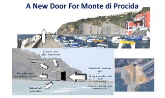 The vision related to the project could be exemplified with the slogan "A new door for Monte di Procida" because the coastal area could be really considered the head of the city
 -
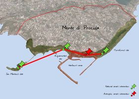 The assumed transect follows a path from the Aquamorta bay, edge of the coast, to the central port sector and then to the other edge of the coastal area, the Torrefumo zone
 -
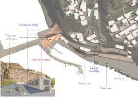 Acupuncture on the anthropic area
 -
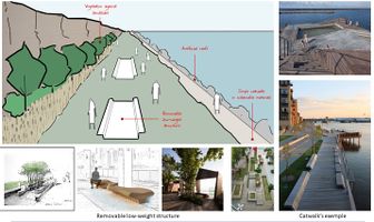 Acupuncture on the natural sites


C.3 From Theory of Change to Implementation
An appropriate regeneration of the site requires a synergistic partecipation between different local social and political strata, in order to take advantage of the potential of each of them, involving both public and private figures.
The planning of the harbour's area would need a cooperation between the City Administration and the private investors. The local government would provide for the physical provision, relying on the support of specialists for the functional reorganization of the place and for the right dimensioning of the retaining wall. On the other hand, the private sector would deal with the management of the various spaces: local businesses would handle the planned commercial areas and the shipping companies would ensure the maritime routes' reliability.
Since the natural sites of Acquamorta, San Martino and Torrefumo are included in the Natura 2000 network, they are governed by particular European and national regulatories: therefore, it is evident that its management should be referred to the local authorities, transposing the overriding guidelines and calling upon experts for an effective protection and a genuine exploitation of the sites. Nevertheless, non-governmental bodies could facilitate the administration of these areas, relaying them to a larger audience and handling the increase in visitor numbers at the same time.
The planning process should be divided into phases, the first of which sould be an overall analysis of the main features of the coastal area in order to define the priority interventions. After that, funds should be collected and then the real designing stage should start. During the deployment phase, first of all the interventions for securing the ridge (like the retaining wall) should be carried out; then, the marine station and the harbour's site should be completed, reorganizing the more deserving area; in the end, there should be accomplished the exploitation's operations on the natural sites. The whole process should last approximately 30 years, according to its mainly public nature, even if its elements have the virtue of being achieved at different times in case of technical or economic issues.
The monetary resources should be primarily raised by the public authorities; anyway, private investors could contribute in funding with a view to the managerial and commercial benefits that could gain from the implementation of the project. Moreover, the whole coastal area could rely on its valuable intangible heritage, composed of its natural and cultural value and its central importance in maritime transport: these elements could justify a kind of self-financing for the plan.
-
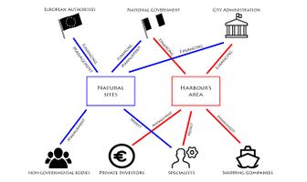 Governance and partnership model for the coastal area's intervention, based on a mutual support of the public and private sector active at Monte di Procida
 -
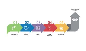 Process timeline that highlights the assumed planning stages, estimating 30 years for its complete achievement


C.4 References
- The Transect - Center for Applied Transect Studies (CATS)
- The Transect as a Method for Mapping and Narrating Water Landscapes: Humboldt’s Open Works and Transareal Travelling
- Site Planning and Design Handbook
- Rapporto 2014 sui tempi di attuazione e di spesa delle opere pubbliche
D. Process Reflection
- Reflect in your intercultural and interdisciplinary team on the outcomes of your study
- Which limitations were you facing?
- What have you learnt from each other?
- What would you do differently next time?
- You can also use diagrams/visuals
- 250 words text