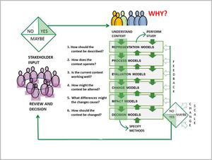
The integrated planning and design framework
Geodesign is design with geography
| Planning and design need to be integrated in a well structured framework |
In his ‘Framework for theory applicable for the education of landscape architects’ (Steinitz 1990: pp.136), Carl Steinitz has described a six-level framework of core questions guiding the planning and design process. Though this framework is regarding landscape architecture, it is also applicable to the related planning disciplines involved in the CO-LAND project. Even if the model is presented linearly, Steinitz points out that in practice, there would be a continuous reflection process with implications from one phase to another, even in a non-linear way. The framework is very useful for communicating, designing and guiding interdisciplinary and transdisciplinary settings, such as the CO-LAND learning process. Iteration, feedback and collaboration are embedded in this overall scheme.
The following illustration shows how the different questions and planning phases are interrelated and further depicts the role of stakeholders and community in this context.
Further Reading
- Steinitz, C. (1990), A Framework for Theory Applicable to the Education of Landscape Architects (and Other Environmental Design Professionals), Landscape Journal, vol. 9, no. 2, CELA/University of Minnesota, pp. 136-143.
- Steinitz Framework for Geodesign, Geodesign Wiki
- Al-Shams, A. R., et al, ”Waterfront Development within the Urban Design and Public Space Framework in Malaysia”, in Asian Social Science; Vol. 9, No. 10; 2013
